
-
 20937 Hits
-
 83.69% Score
-
 17 Votes
|
|
Route |
|---|---|
|
|
54.52718°N / 3.01525°W |
|
|
Mountaineering |
|
|
Winter |
|
|
Less than two hours |
|
|
UK Grade I/II |
|
|
OVERVIEW
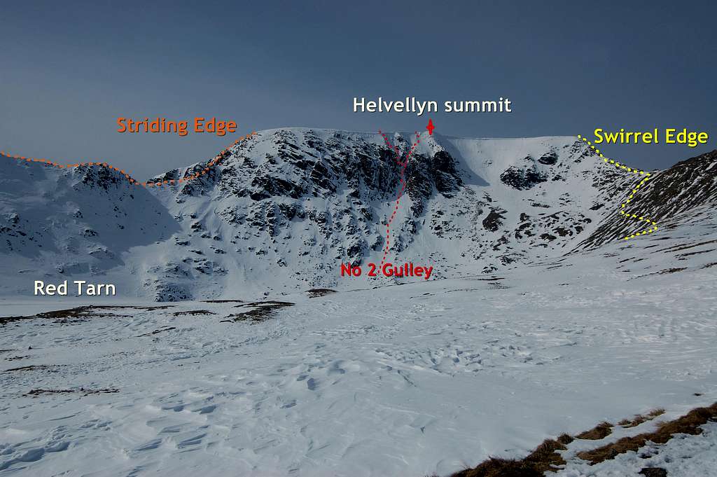
Number 2 gulley is a grade I/II winter climbing route on the East Face of Helvellyn - the 3rd highest summit in England at 950m/3114ft. Vertical height is 232m/761ft from lowest possible start on the shores of Red Tarn, to the finish of the route, just metres to the south of highest point of Helvellyn. Only the top approximately 150m of the climb is on gradients steep enough to be called climbing. The are 2 alternate finishes for the final 50m or so of the route - where the gulley splits into an easier R fork (and continuation of main gulley) and the slightly harder L fork (a narrower side branch of the main gulley). The R fork is allegedly Grade 1 and L fork Grade II.
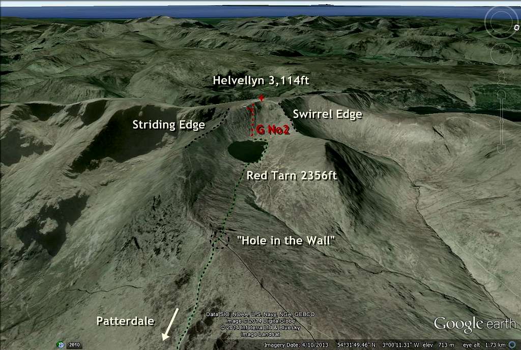
The East Face of Helvellyn forms the back wall of Red Cove, the 'arms' of which are formed by Striding Edge to the south and Swirral Edge to the north - and either of which can be used as a route for descent from routes on East Face - although most would use Swirral Edge, in this circumstance.
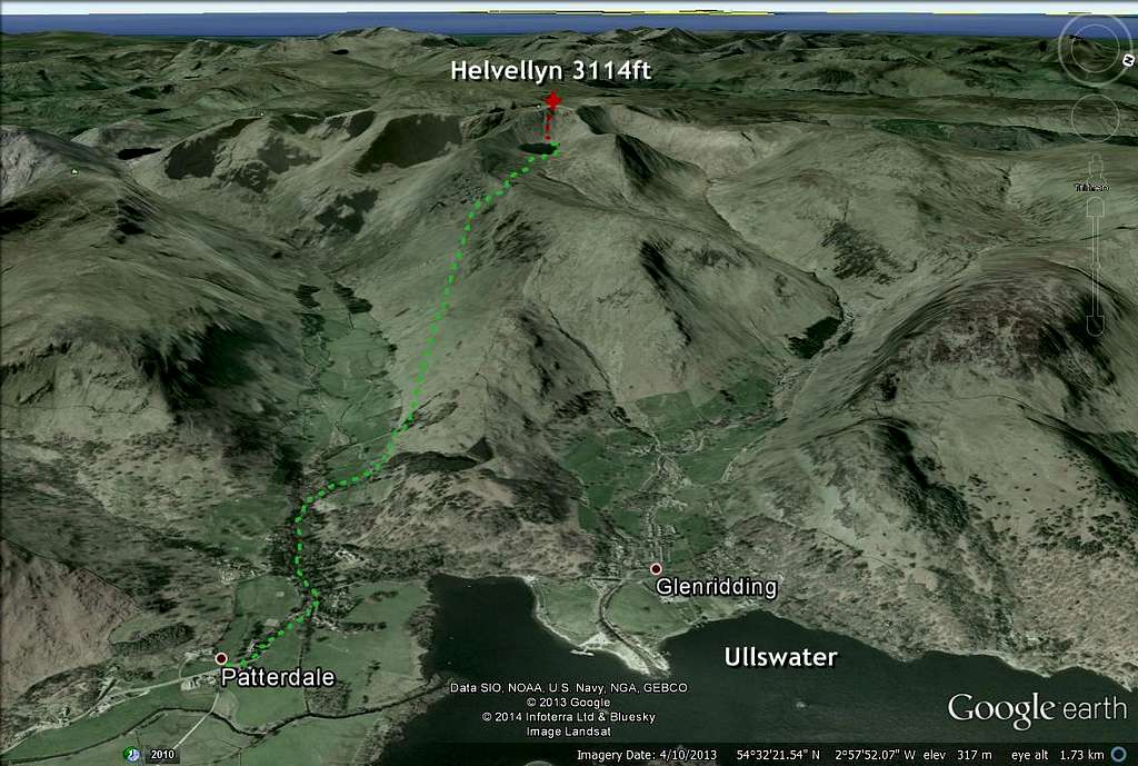
Helvellyn is situated in NE corner of the English Lake District - and is accessed via a pleasant path, leading up from the normal starting point at the village of Patterdale. This approach initially follows valley of Grisedale, before angling away towards Red Tarn and Helvellyn. It takes 2-3 hours depending on level of fitness and conditions. A longer approach can be made from the larger centre of Glenridding, a few km to the north.
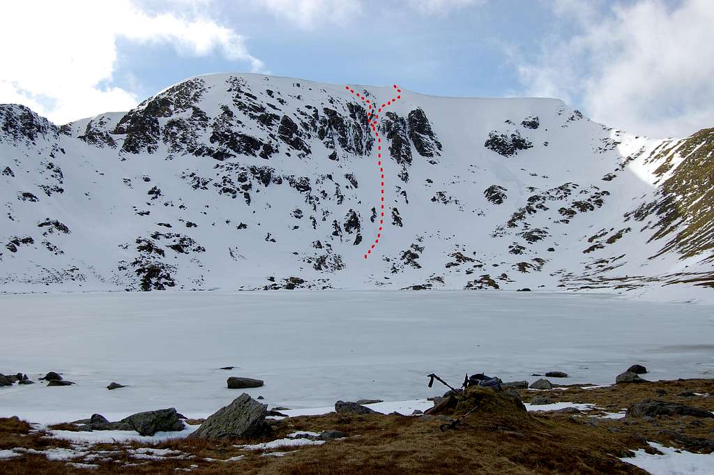 View of Helvellyn East Face & No 2 Gulley March 2014 | 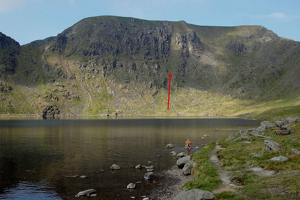 View of Helvellyn East Face & No 2 Gulley June 2013 (note Jake, the dog) |
GETTING THERE
From North
Leave M6 motorway at Junction 40, follow A66 a short way and then take a left turn onto A592 - and passing through Pooley Bridge, Glenridding and then Patterdale. From M6 J40 to Patterdale is 13 miles, about 23 minutes on slow roads.
From South
Leave M6 motorway at Junction 36, following a longer approach via A590/A591 to Kendal then Windermere - and thence to the north on A592 and Patterdale - followed by Glenridding. From M6 J36 to Patterdale is 30 miles, about 40 minutes on fairly slow roads.
Approach from Patterdale
Park close to Patterdale Hotel, in pay & display car-park at GR 396159 - on opposite side of main road to the hotel. For the day only pay at meter, but for overnight parking pay at the hotel reception.
Leave car-park and head along main road WNW for 0.5km. Just before a bridge take a left turn up a narrow lane heading SW into Grisedale.
After approximately 200m lane takes a right angled turn to the right - follow lane a further 800m to where it ends at a farm gate. To the right is a smaller gate and sign for the route to Helvellyn and Red Tarn. Walk through open pastures for a short distance, over a foot-bridge over Grisedale Beck - and up to a stone wall and a small wood.
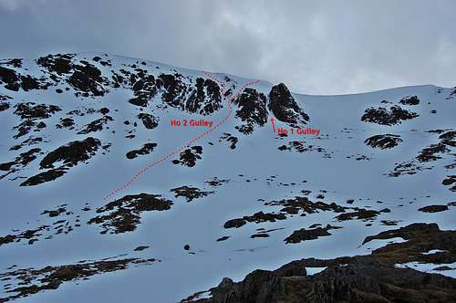
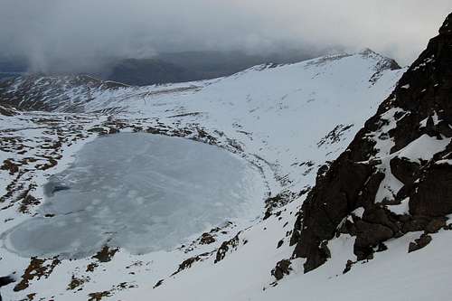
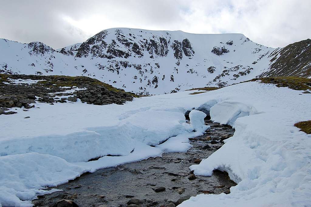
Passing through a gate in the wall the main path up to Red Tarn is reached and turns leftwards. The route now follows a rising traverse west along the northern side of Grisedale valley - and gains about 450m height over a distance of about 2km. The path now leaves Grisedale at "The hole in the Wall" at GR 359155, at an altitude of 700m. From there path heads further to the west, about a kilometre horizontally to the shores of Red Tarn, at 718m. This stage of the walk-in is rewarded by increasingly spectacular views of Helvellyn East Face, with No 2 Gulley rising pretty much up the centre, with No 1 gulley also prominent just a little to the right.
It takes 2-3 hours to reach Red Tarn from Patterdale - nearly 600m height gain over 4.5km distance.
Google Earth view of approach to Red Tarn & Helvellyn East Face - 1
Google Earth view of approach to Red Tarn & Helvellyn East Face - 2
CAMPING
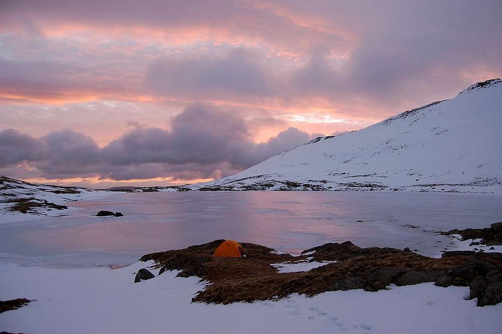
It is easy to access routes on East Face of Helvellyn and return in a day. However, if planning to ascend more than one of the climbs - or if wanting to make a very early start to catch optimum conditions - then I would recommend the shores of Red Tarn as a rather lovely place to camp. Outlook is to the east - so ideal to catch the sunrise - as I found in March 2014:
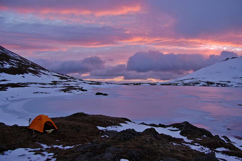
Camp site by Red Tarn - at dawn on 6th March 2014
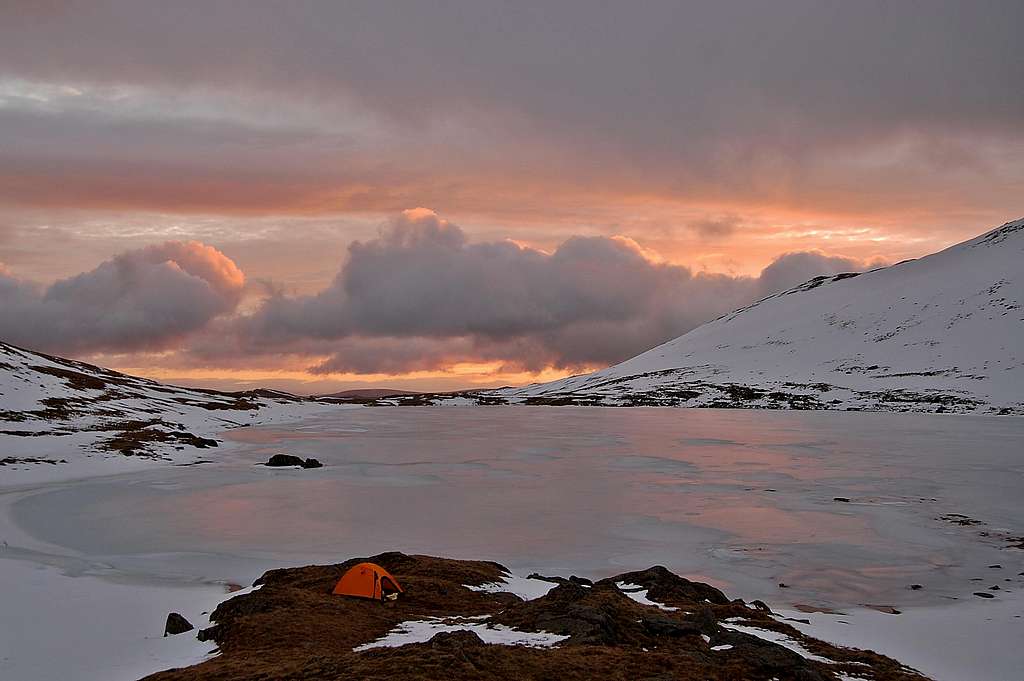
Camp site by Red Tarn - at dawn on 6th March 2014
OBJECTIVE DANGER
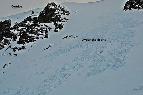
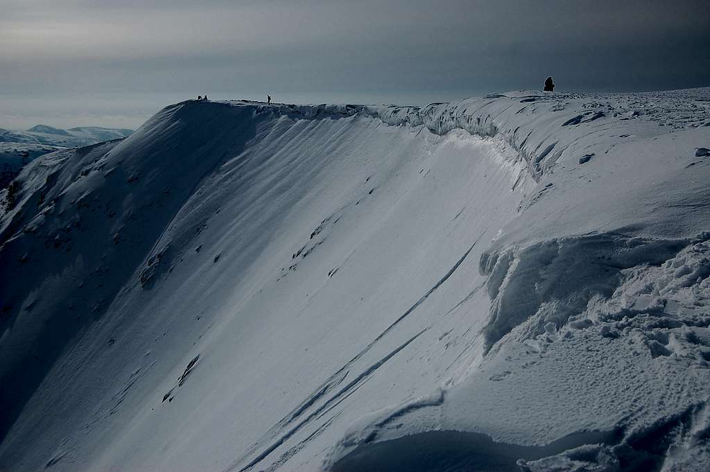
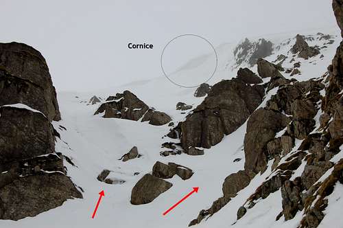
Avalanche debris and cornice threat Helvellyn East face 5th March 2014
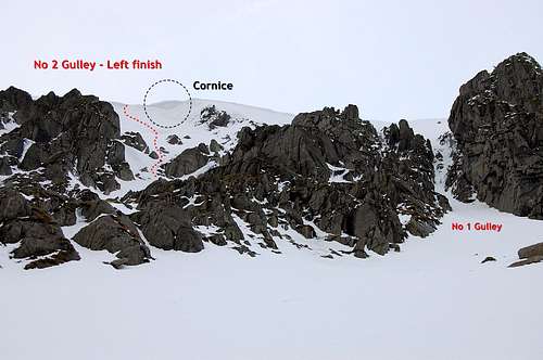
The cornice threatening exit of No 2 Gulley LH Fork
This is a winter climbing route. Although by SP standards the altitudes involved are exceedingly modest, the English winter weather can be savage, even on lowly Lake District hills barely topping 1000m. English winter weather can also be highly variable from year to year - and within a season. In some years there may be virtually no snow at all - and none of the winter climbing routes come into condition. In other winters there can be heavy falls of snow and brilliant conditions - but sometimes also interspersed with periods of thaw, including heavy rain at all levels - wrecking good conditions in a couple of days - and/or increasing objective danger from avalanches and cornice collapse.
In 'good' seasons the entire East Face of Helvellyn is subject to cornicing to a greater or lesser extent, all the way along the top. Indeed, breaking through the cornice may be the 'crux' of some of the Red Cove routes in some conditions. Having said that, when climbing conditions are good, plenty of visitors will ensure that cornices are breached at all the optimum places early on. However, site of the breaches may vary - and this may result in significant variations in route end-points. For example, in March 2014, when I climbed No 2 gulley, the nearest breach was directly above No 1 gulley - so to finish ascent of No 2 involved a traverse across to join the top 20m of No 1.
With cornicing, of course, goes risk of cornice collapse: thus this route and others nearby, may prove unwise propositions during a thaw - and extra caution may be needed in the Spring. In March 2014, the greatest cornice build-up I observed was directly above the left fork variation of No 2 gulley. Completion of this part of the climb would have entailed a prolonged traverse underneath, to reach the nearest easy breech. Having read of cracks being observed in the snow, well back from the edge of the face - and with the 'nearly-thaw' conditions I encountered, it seemed sensible to give this part of the route a miss - and keep to the standard R fork finish.
Avalanches may occur on the East Face of Helvellyn. Around the various buttresses there are a lot of open slopes, just perfect for spawning slab avalanches. On my visit in March 2014 I saw evidence of a recent small slide between the entrances of No 2 and No 1 gullies - and a much bigger slide coming off the larger expanse of slope on the way towards Swirral Edge. I dug an avalanche pit and whilst I found various layers, they were clearly well bonded and I felt in no danger during my visit. The two slides I saw must have occurred a couple of days earlier following the last snow fall - and high winds. Subsequent freeze-thaw appeared to have stabilised things again.
Although I didn't see or hear any stone-fall, there is plenty of potential for loose material dropping off the surrounding buttresses. It would seem prudent to wear a helmet (though I have to confess I forgot to take mine in March 2014!).
For up to date information I strongly recommend visiting the Lake District "Weatherline" website. During the winter season a "Fell-top Assessor" climbs to the top of Helvellyn every day - and submits a daily photo and detailed report on weather and conditions, through the website. This is an absolute gem of a resource - and I wouldn't think of setting foot on Helvellyn in the winter without looking at the latest update.
Mountain Rescue
Call 999 or 112 and ask for Police; Mountain Rescue. The European emergency number 112 is the best to use since this has the additional features of being able to 'break into' the best network when reception is borderline - and can help rescue services triangulate position.
Modest cornice formation at top of East face Helvellyn April 2013
THE ROUTE
Helvellyn East Face & gullies from Lake shore just below
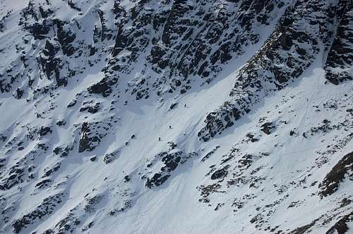
Party of 3 climbers entering bottom of No 2 Gulley April 2013
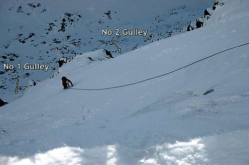
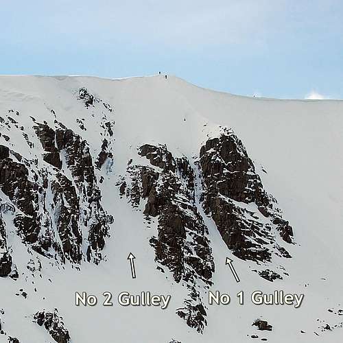
It is an easy matter to identify No 2 Gulley. It is the widest of the two prominent parallel gulley's - which terminate just to the left of the little prominence in the middle of the crest of Helvellyn East Face. The right hand and shorter, steeper gully is No 1 (Grade II/III).
Above the western shores of Red Tarn easy angled slopes rise up towards the foot of the buttresses and gullies. In summer these slopes are a mix of grass and boulders. In a good winter, there may be smooth snow cover - just occasionally pierced by some of the larger rocks and hummocks. As the bottom of the gully is approached the gradient gradually increases, such that by the time the gulley is actually entered, about 100m above the lake, the angle is at around 45°. This gradient remains fairly consistent for the next approximately 80m of ascent - up to where the gulley forks.
About another 50m of vertical remains above the fork - in either direction. In addition there may be substantial traversing to do in either direction depending on where the summit cornices are breeched.
Just below gully entrance looking south to Striding Edge
Just above gully entrance looking down on Red tarn
Left Fork
This variation is Grade II and involves a short steep scramble up between rocky bluffs, to a wider slope directly below the summit cornice. The exact finish depends on the state of the cornice - and where the nearest breech is. When I was there in March 2014 this part of the route was threatened by the largest section of cornice build-up on the face. Thus the route would have entailed traversing quite a long way, directly underneath this hazard, in order to reach nearest exit. With borderline freezing conditions, I decided to keep well clear - and followed the (normal) right fork.
At the junction, where gulley divides to L & R fork
Right Fork
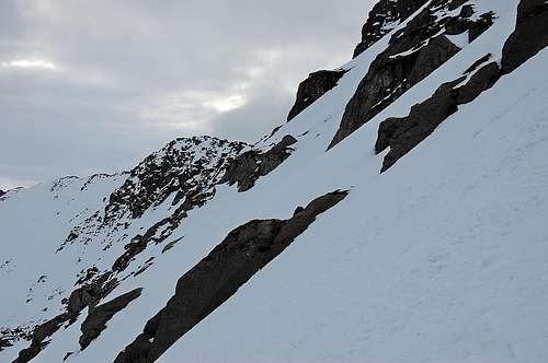
The Right Fork is Grade I and involves angling upwards, still within the rocky walls of the main gulley, to the steepest section - apart from the final few metres of the exit. I'd estimate the angle reached 50-55° for about 15m, before gradually relenting to 45-50° - which made me feel it was a little hard in the grade of I - and I'd have given it Grade I/II.
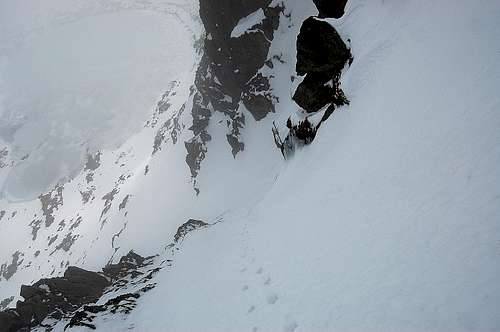
Looking back just after steep section of RH fork
In March 2014, the nearest breech in the very modest cornice at this point, was at the top of the prominent spur rising directly above No 1 Gulley. Thus exiting No 2 Gulley on this occasion, entailed making a fairly long rising traverse to the right to reach it. Having reached the spur it was then a matter of front-pointing straight up the final 15-20m to the breech in the cornice and the top. Just at the very top the angle steepened to 50-55° for the final few metres.
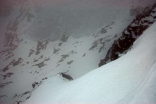
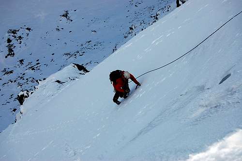
In March 2014 I soloed No 2 Gulley, as indeed many do. Sadly I completed the top part in encroaching mist - so what should have been sensational views straight back down to the lake were somewhat limited - albeit, it was 'atmospheric'.
However, it just so happened that I had taken a couple of photos of a roped party completing this route in the exceptional conditions in April 2013. Unknowingly I had taken the photos right where I would be exiting the route myself 11 months later. Just below is a view showing one of the climbers tackling final ascent - with back drop of both No 2 and No 1 Gully exits behind. As it happened, I believe this climber and his leader came out of No 1 Gulley - tracks just visible in back ground suggest that it was possible to climb almost straight up above No 2 Gulley - without having to traverse across, on this occasion.
Own view looking back on exiting top of route March 2014
Same view at exit of route taken April 2013.
THE SUMMIT
Somewhat limited view after soloing No 2 Gulley in March 2014
A better view of exit from route taken in April 2013
View of a roped pair exiting one of the gullies from below
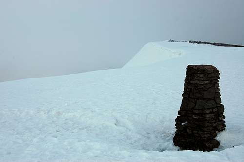
Helvellyn summit cairn March 2014
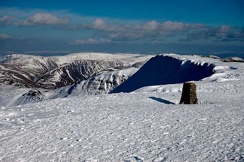
Helvellyn summit cairn April 2013
DESCENT
There are two main options for a swift descent back to Patterdale:
Striding Edge
This is an easy but exciting scramble in summer and in winter is rated as a Grade 1 climb. Click Striding Edge to link to SP page with more detailed account of this famous ridge. Under winter conditions use of ice-axe and crampons - and for some, a rope - is advisable.
Swirral Edge
This is also a scramble in summer conditions, but much shorter than Striding Edge. It is also a Grade 1 climb in the winter - since the initial descent is steep and exposed - and numerous accidents have occurred here. In April 2013 it was possible without crampons, but with aid of an ice-axe - but not so March 2014, when it was especially treacherous.
The tracks from both Striding and Swirral Edge meet at the "The hole in the Wall" at GR 359155, at an altitude of 700m. From here it is simply a matter of reversing the approach, down the long descending traverse on northern side of Grisedale, crossing Grisedale Beck - and then following lane and road back to Patterdale.
East face of Helvellyn showing Striding and Swirral Edge - as descent routes.
Easier routes
- Heading south via Nethermost and Dollywagon Pike and Grisedale, to Patterdale
- Heading north via Whiteside Bank and Glenridding Common, to Glenridding.
WHEN TO GO
As above English winters are extraordinarily variable! If possible they are even more variable than Scottish ones. (Again) As above, some years the winter climbs never come into condition at all. In an exceptional year (E.G. 2010) there were climbing conditions as early as mid to late November. In 2013, after very late start, climbing conditions stretched into mid April. At the end of 2013, the new season showed great promise with early snow-fall and winter climbing before the end of November - but this was then completely devastated by soaring temperatures to double figures centigrade even on the tops - plus heavy rain - plus high winds. By early December all that beautiful early snow was gone! (As I found on 5th/6th March, it did come back... )
The best months are January and February. These two months would offer the highest probability of reasonable conditions - but without being at all guaranteed.
REDTAPE
Common sense rules apply...
TAKE ONLY PICTURES... LEAVE ONLY FOOT-PRINTS
There is no red-tape as such. But it is expected that hill-goers will show respect to land-owners by leaving any gates as found, being careful round live-stock especially lambing season (February to May) - and packing out any waste.
EQUIPMENT
Taking into consideration the above warnings about fickle English winter weather, it is as well to follow weather updates and dress appropriately. But whatever the forecast it is as well to pack waterproofs and extra warm layers...
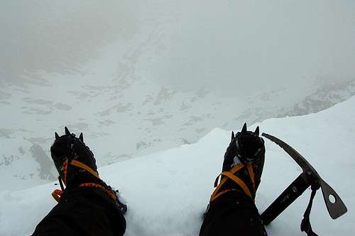
Ice Axe - minimum one, but ideally a 2nd ice tool/ice hammer an advantage.
Crampons - I got away with walking (C1) crampons and a pair of B1 boots in March 2014, but in icy conditions B2/3 boots and appropriate crampons would be advisable.
Rope (although experienced climbers will probably solo this route in good conditions).
Slings/rock hardware (if rope is used).
Helmet
OS Map: Explorer 1:25,000 Sheet OL5 "The English Lakes, North East area - Penrith, Patterdale & Caldbeck"
Compass/GPS
Mobile Phone... But - no reception until summit of Helvellyn - and then it is somewhat intermittent. (But, as above, may 'work' best for emergency call using 112)
EXTERNAL LINKS
Lake District/Helvellyn Weatherline
UK Mountain Weather Information Service (MWIS)
East face 5th March 2014
Hope you have as much fun as I did!