***Page best when viewed on a widescreen monitor. My apologies to those folks who do not have one...I hope your experience is not tainted***
WHEN VOTING, PLEASE KEEP IN MIND THAT THIS IS A WORK IN PROGRESS. I PLAN TO CONTINUE TWEAKING IT AND ADDING MORE INFORMATIONAL PICTURES, AS WELL AS LINKS AS I LEARN MORE ON THE TOPIC. JUST KEEP THAT IN MIND, AND HAVE MERCY :D
"That Peninsula that Catches Your Eye"
When one looks at any well-made map of America, the eye is unavoidably drawn to that giant peninsula jutting out defiantly into Lake Superior. That peninsula that catches your eye has a name, and that name is the Keweenaw Peninsula. Located in the Upper Midwest, the
Keweenaw (and
Upper Michigan as a whole) does not get very much attention from the mountaineering world, and rightfully so since the highpoint of the state (located very near the Keweenaw!), Mt. Arvon, is a mere 1979 feet above sea level. However, what the Keweenaw lacks in height it more than makes up for in scenery and remoteness. With a total area of roughly 1,000 square miles and a population hovering around 2,500 people (most of whom live in Copper Harbor) the Keweenaw is a playground for the intrepid adventurer who desires to visit a variety of wonderful places and do so while hardly glimpsing another person. There are a myriad of places to visit in the Keweenaw, including mountains (
Mt. Baldy,
Brockway Mountain,
Bare Bluff and
The Cliff Range, among others),
waterfalls (Montreal Falls, Hungarian Falls and Douglas Houghton Falls, among others), remote beaches, virgin forests, trophy fishing lakes and countless historic sites (most of which are abandoned mines or mining towns).
![Brockway Mountain]() A view of Mt. Baldy in the Autumn. Baldy is a prominent hill that has its roots in the basic geology of the region.
A view of Mt. Baldy in the Autumn. Baldy is a prominent hill that has its roots in the basic geology of the region.
The Keweenaw is home to the largest native copper ore deposits in the world and, as a consequence, saw an incredible boom in the mid-1800’s when people came looking to make a few bucks out of that beautiful brown metal we all know as wiring. The Copper Industry drove the economy of the region for over 100 years, and at times its profitability was so great and the hustle and bustle became so big in the area that the city of Calumet was considered as the capital of Michigan. This history of extensive mining and a plethora of old mining communities (Quincy, Calumet, Central, Cliff, Phoenix, Delaware and Mohawk make up only a small fraction) makes the history of this small area uniquely similar to the Great Western States, and as such it deserves a good looking at just like any other mountainous region shaped by massive geological forces.
The Keweenaw Peninsula is home to some of the most interesting geology in the country, and along with other areas of the Upper Peninsula of Michigan contains some very scenic and unique landforms that deserve special attention. Hence my attempt to tell the tale that is the history of the Keweenaw Peninsula, dating back over a billion years to the time when the Great Lakes did not exist and before even dinosaurs roamed the earth.
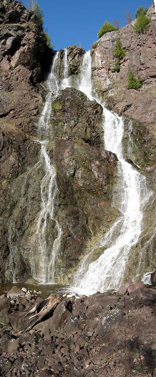
![Hungarian Falls]() Hungarian Falls, as well as Houghton Falls (right) both occur near the Keweenaw Fault as their streams cross from west to east through rifts caused by volcanic activity.
Hungarian Falls, as well as Houghton Falls (right) both occur near the Keweenaw Fault as their streams cross from west to east through rifts caused by volcanic activity.Rewind: 1 Billion+ Years Ago
The rather complex geology of the region has its beginning over a billion years ago in the Precambrian Era. The most noticeable and influential feature in the Keweenaw is the aptly named Keweenaw Fault and the rugged hills that parallel it on its west side. This fault roughly parallels the ancient Mid-Continental Rift that once threatened to tear North America apart. The Mid-Continental Rift formed as a separation of the continental crust spanning from Kansas up through Minnesota and down the present center of Lake Superior, then turning south and ending rather abruptly north of Detroit, MI. Similar to the modern Rift Valley in eastern Africa, this rift never got big enough to splinter the continent into pieces, but touched off a series of events that formed the most geologically noticeable features of the region today.
![Mid-Continental Rift]() A USGS diagram detailing the Mid-Continental Rift in the Lake Superior vicinity.
A USGS diagram detailing the Mid-Continental Rift in the Lake Superior vicinity.
These large basaltic outcroppings present in the Keweenaw (and the Porcupine Mountains and Isle Royale for that matter) more or less form the “spine” of the peninsula. The hills formed by them are noticeable throughout the peninsula, particularly in the northern end, including
Brockway Mountain,
Mount Baldy, Mount Horace Greeley, Mount Houghton, Mount Bohemia,
Bare Bluff and the
Cliff Range. The basalts got there as a series of lava flows that emanated from the great rift that formed in the continent. These lava flows are today called the Portage Lake Lava Series. In between lava flow events, of which there were roughly 20, there were periods of erosion and deposition of sandstones and conglomerates, as well as some shales. These resulted in the modern day formations of the Freda as well as Jacobsville Sandstones, the Copper Harbor Conglomerate and the Nonesuch Shale. All of these formations are visible today throughout the region as well as in other areas of the Western Upper Peninsula.
![The Rock Forming Process]() A USGS diagram explaining better than I can how the layers of sedimentary and igneous rock got to be there today.
A USGS diagram explaining better than I can how the layers of sedimentary and igneous rock got to be there today.
Eventually, after millions of years had passed, the lava flows ceased and the great basin began to collapse under its own weight. This, along with the action of plate tectonics within the continent, caused a gigantic syncline to form in the basin. This syncline is located directly under present day Lake Superior, and the filling in of the syncline with sediment and runoff is what formed the greatest freshwater body on Earth. (Thus, contrary to popular belief, Lake Superior was not carved out by glaciers, but rather it is the result of the filling of a humongous basic created by volcanic action eons ago.) The edges of the basin cracked off and raised up, leading to the present day Keweenaw fault, along which is a long chain of high rocky hills, as well as
Isle Royale. The fault runs from the tip of the Keweenaw straight through to the border of Wisconsin near Hayward. East of the Fault, the terrain is noticeably flatter, because the land was unaffected by the syncline and remains more or less flat as it was when deposited.
The final major events that carved out what is known as the Keweenaw Peninsula today were the advances of the glaciers during the Ice Ages of the past tens of thousands of years. The great ice sheets that covered the area carved out many interesting features, as well as shortened many of the once mighty basalt hills that ruled the area.
![The Lake Superior Syncline]() One final diagram by the USGS showing the massive syncline linking Isle Royale to the Keweenaw.
One final diagram by the USGS showing the massive syncline linking Isle Royale to the Keweenaw.Fast Forward: Today
Today the massive volcanics that once took place in the region are long since ancient history, and as a result of time and glaciation the geography of the area is rather mellow compared with other regions in the West (though quite rugged when compared with most of the Midwest). However, the signs of the past are present everywhere to remind the savvy adventurer of times past.
Perhaps the most obvious evidence of the geological history is the uncanny matching of the Keweenaw’s geography (and the
Porcupine Mountains, further west, for that matter) and
Isle Royale’s. It might be little known that these two features are on the opposite ends of the syncline, but are formed of the same rock formation. This explains the strange similarities in the hills of the two locales, as well as the similarity of rock types. The two images below show the striking similarities between the Keweenaw and Isle Royale as seen from above. Note the very visible parallel bands of rock present in both locales; these are the lava flows spoken of earlier.
This panorama from Mt. Baldy begins looking northeast from the summit towards Lake Superior, progresses towards Brockway Mountain (middle distance; due east) and pans past Mount Houghton (distance; east-southeast), then finishes with distant Gratiot Mountain to the southeast. This is a prime example showing the hills that dominate the northern Keweenaw. |
![Greenstone Ridge]() A photo (courtesy dwhike) showing the Greenstone Ridge, Isle Royale's most prominent central ridge. The terrain visible is similar to much of the Keweenaw.
A photo (courtesy dwhike) showing the Greenstone Ridge, Isle Royale's most prominent central ridge. The terrain visible is similar to much of the Keweenaw.
Other interesting features in the Keweenaw that display the geographic history are the massive amounts of conglomerate to be found all around the Copper Harbor area as well as in the Porcupine Mountain range 80 miles west of the Keweenaw. Hiking out to Lake Superior within the Porcupine Mountains Wilderness State Park on the Lake Superior Trail, you will encounter massive amounts of cobble-sized stone in the trail. This is the same conglomerate, albeit weathered much further, as that found in Copper Harbor. The incredible rocky shorelines that appear in sheets found in the Keweenaw and the Porcupine Mountains are prime examples of the Nonesuch Shales that formed on the west side of the Keweenaw Fault. The sandstones on either side of the fault, Freda on the west and Jacobsville on the east, are readily visible in many places, including near L’Anse, MI (Jacobsville) and the impressive Freda Cliffs along Lake Superior (Freda).
![Freda Cliffs]() The cliffs located in Freda, MI are a prime example of the sandstone in the area (in this case Freda Sandstone).
The cliffs located in Freda, MI are a prime example of the sandstone in the area (in this case Freda Sandstone).![Porcupine Mountains]() An outcropping of Nonesuch Shale in the Porcupine Mountains. The same formation also juts out in places in the Keweenaw.
An outcropping of Nonesuch Shale in the Porcupine Mountains. The same formation also juts out in places in the Keweenaw.In Conclusion
![Geological Map]() A geological map of the Keweenaw showing the particular types of rock and their location.
A geological map of the Keweenaw showing the particular types of rock and their location.The examples given above only touch the surface when it comes to geologic phenomena in the Keweenaw. Entire books could be (and have been) written on the subject that go into much greater detail. I have attempted to the best of my ability to give a brief, yet informational, glimpse into the past and what caused this beautiful area of the country to form. If you would like to learn more (and it is quite fascinating) I would recommend consulting the following sources, several of which I used for figures and information while researching this article.
Mineralogical Society of America page on the Keweenaw.
USGS Bulletin on the Geology of Isle Royale
“Self Guided Geological Field Trip to the Keweenaw Peninsula, Michigan” by Theodore Bornhorst and William Rose
Special Thanks
Special thanks to Dr. Ted Bornhorst and Dr. Stan Vitton who sparked my interest in the topic. I know everything I do as a result of sitting in their lectures and listening to them tell the above information to me multiple times. (If you guys are reading this, yes I was listening that whole time...) More or less this is a regurgitation of what stuck when they taught…The real knowledge of the subject lies with these men and a handful of other colleagues, not with myself. :D


Comments
Post a Comment