Day trip to Wales
I had "discovered" the Snowdonian mountains in August 2008, and been back a good few times since then to an area that will always be the major Welsh mountain walking attraction for me. But I did know there were other parts of Wales with mountains! And by late April 2009 decided it was time to visit one of those: the Brecon Beacons in South Wales. In particular one of the horseshoe walks taking in the highest summit of the Beacons, Pen y Fan, (2906 feet).
An attraction of the Brecon Beacons is that it is just possible to do a decent walk there on a day trip from my home near Maidstone in Kent, South East England. Traffic conditions permitting of course, so I had packed an overnight bag in case I got delayed, or was just too tired to drive back the 220 or so miles on our very crowded UK roads.
But traffic on the way down was fine after a very early start from home, and that got me off to an 08.20 walk start from the National Trust car park at Cwm Gwdi, South of Brecon. With Pen y Fan, my main goal for the day, in view very soon.
I was using the 1:25000 Ordnance Survey map for the area, OL12, from which I had selected a route that would take me via the very steep North ridge of Cribyn, (2608 feet), the mountain to the East of Pen y Fan that, by passing over it’s summit would give what I felt would be an excellent horseshoe walk over a full days effort in the Beacons.
By choosing the longer of the routes that would cover the highest peaks in the Beacons, my plan was I should get a relatively quiet walk in a area that can see large numbers of walkers on the very popular shorter routes.
So I dropped downhill from the car park and used lanes and paths, though and past small hill farms, heading for a track shown on my map as heading up to that Cribyn North ridge. Which in it’s earlier part is actually a ridge named called Bryn Teg.
The Wrong Track
It was around here that my very early start caught up with me! I was on a really good track and just kept walking it, until I eventually realised that I was by-passing the ridges up to Cribyn, and instead heading for the small shoulder at Bwlch Ar y Fan between Fan y Big and Cribyn. That was a route up to Cribyn, but I particularly wanted to climb the very steep North ridge as I had anticipated from my research that would be the most exhilarating part of the day for me.
So I now, rather belatedly, checked my map, and saw that the path I wanted over the ridge lines was very indistinct and would have left the broad trail I was on some considerable way back. I was certainly not going to retrace my steps, so I just yomped up the very steep and grassy slope on the side of the ridge, eventually getting to the top of Bryn Teg.
Getting to the top of Bryn Teg, near the point where Cribyns North Ridge started, gave a lovely view to Pen y Fan, the highest Summit in the Brecon Beacons. It also gave me an excuse for a much needed breather after the steep slog up the side of the ridge.
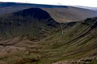
Cribyn North Ridge
I was soon off along the almost level Bryn Teg, but in front and getting closer with every pace I took was the very steep North Ridge of Cribyn. When I reached it I could see it was basically small rocky bits cut into the steep grassy slope, and I was soon on my way up.
Exhilaration I had wanted, and that was what I got on that ascent! And it came as no surprise that the steepness of the climb and the drop offs either side, especially to the right near the top, were steep enough to trigger my vertigo as I made my ascent. So I just concentrated on where I was putting my feet and looking for the occasional place to steady myself with a hand. I stopped a few times, gathered myself and took in the views around me. And they were great. Just a pity that the forecast sunny day had lasted very briefly, and cloud was now gathering from the West.
I soon reached the summit of Cribyn, and turned to look back down at the route I had just come up. Not one I could ever easily descend as just looking down at it certainly gave me very unpleasant and unnerving vertigo.
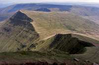
A breather and a slurp of isotonic drink and I was on my way, dropping steeply to the shoulder overlooking the cliffs of Craig Cwm Sere. Ahead was Pen y Fan and it's massive and steep East cliffs. And just behind slightly to the South the flat top of Corn Ddu.
Pen y Fan and Corn Ddu
Over 700 feet of ascent ahead of me from the shoulder up to the summit of Pen y Fan, and I made good progress, closing on the top of Pen y Fan.
With my final summit of the day, Corn Ddu, (photo right), now looking much nearer as well
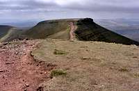
Pen y Fan, with a much closer and easier route up from the South was quite busy, so I hurried down and across the small shoulder to get onto the top of Corn Ddu. Where there was not much of a view as the gathering cloud was low and obscuring what I am told is a very good view. So it was back over the shoulder for a quick lunch break on the top of a quite busy Pen y Fan.
| |
|
|
| The views from the top of Pen y Fan |
The longer way back
Finishing my lunch I set off quickly down the the initial very steep and very badly eroded descent, (photo right), to the North that set me on the route back to my car.
Approaching Allt Ddu I forked right assuming I could find a way back, (well, there did seem to be some sort of intermittent path on my map), to my car across a valley and a small stream. No such luck! After slithering down the steep western flank of Allt Ddu I found fences and a deeper than expected stream barred my way at a point I could almost reach out and touch my car, (well maybe not that close, but I could see it!).
The intermittent path shown on the map was faithfully re-created on the ground, so I just followed my nose. Climbing fences, stone walls, some gates and wandering carefully through fields packed with great flocks of sheep. Finishing with a tiring uphill walk on a lane back up to the National Trust car park at Cwm Gwdi!
But that didn't spoil a really great first visit to the Brecon Beacons, and neither did the long drive home that again was not troubled by any significant traffic delays.
Back home I reckoned the considerably extended route I had followed had seen me cover in excess of ten miles and around 3,300 feet of ascent. By my standards a worthwhile day in the mountains, despite the long day needed to do it without bothering with an overnight stay away from home.


Comments
Post a Comment