
-
 5567 Hits
-
 84.27% Score
-
 18 Votes
|
|
Mountain/Rock |
|---|---|
|
|
41.82100°N / 9.28044°E |
|
|
Corsica |
|
|
Trad Climbing, Sport Climbing |
|
|
Spring, Fall |
|
|
2005 ft / 611 m |
|
|
Overview
Geographical classification: Corsica - Corse > Bavella Massif > Aiguilles d'Ornucciu
Aiguilles d'Ornucciu
Aiguilles d'Ornucciu is a very small group of fine granite peaks, Castellu d'Ornucciu 611 m and its satellite Castellucciu d'Ornucciu 564 m, overlooking to the North the Canyon de la Vacca, inside which it flows the river Solenzara with its crystal clear waters through the granite cliffs and gorges. Both the peaks are located in the vicinity of Bocca di Larone 608 m, the Eastern entrance to the Bavella Massif and both offer beautiful climb on extremely carved rock, about ten pitches long. Castellu shows a more massive and striking structure; its reddish and charming West wall - about 250 meters high - is incredibly riddled by the "tafoni", which give it the appearance of the Emmental Swiss cheese. On this wall there are some interesting climbing routes, often attended in reason of their beauty and even for the short approach from the D268 road.

|

|
Situated on NE of Castellu, Castellucciu is less flashy, but perhaps even more interesting from the point of view of climbing. The South wall is less sculpted and more steep, showing more technical and sustained routes, but also the shorter West wall offers beautiful climbs.
History
The Castellu, whose real name in Corsican dialect was Rocca Taddata (the "cut rock") was the main castle of the Lord of the Southern Island, Rinucciu Della Rocca, built on a rocky side of Bavella massif. It was conquered by the Courses of the Office de Saint-Georges in the year 1507.

|

|

|
Along the descent from the peak, you can still see, below the summit, imposing remains of the ancient castle with the various rooms carved into the rock. Smaller remains of the old building, like a tanker, dry stone walls, an oven are also visible in the upper part on Castellucciu.
Getting There
Access to the Island of Corsica
The magnificent island of Corsica-Corse, l'Ile de Beauté (the Island of Beauty) belonging to France but much closer to Italy, can be easily approached by plane (airports both in Bastia on the Eastern coast and Ajaccio on the Western coast) and by ferry-boat from Livorno and Savona italian ports. The most convenient destination in Corsica to visit the Bavella area, one of the wildest region of the island, is the airport of Bastia if you’re getting there by plane; the same Bastia port if you’re getting there by ferry-boat.
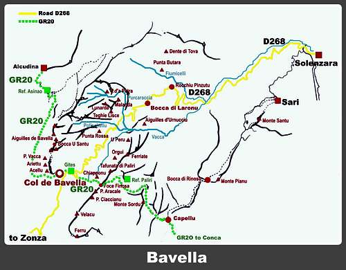
Getting there from Solenzara
- From Bastia (Corsica Eastern coast) follow the road RN 198 to Solenzara; a few kilometers before getting to in Solenzara turn to left, taking the road D268 towards Bavella Pass, reach Bocca di Larone 608 m and pass the col. At about 1,5 km from Bocca di Larone, near a bend along the road, you will find on the left the parking of Canyon de la Vacca.
Getting there from Col de Bavella
If you are starting from Col de Bavella, take the road RN 198 descending in the direction of Solenzara. At about 1,5 km before Bocca di Larone, near a bend along the road, you will find on the right the parking of Canyon de la Vacca.
Walking approach
Take the good path starting from the parking lot and heading to South-East across the vegetation. At first rising slightly, successively the path descends sharply towards the saddle called Bocca Ornella. Both the two fine reddish towers appear: the first summit on your right is Castellu, while further down on the left is clearly visible Castellucciu. Near a large granite boulder the path forks.
Castellu d'Ornucciu routes (link to Allegria route report )
Castellu d'Ornucciu routes overview from left to right (French Scale)
Access to Castellu - From the crossroad near the boulder take the path that starts right and goes down towards the canyon inside the wood. Descend along the path approaching the wall getting a scree (cairns). Leave the main path and cross the scree, scramble up a rock reaching a ledge and follow it, reaching a pine at the starting point of the route "Allegria" (40 min.).

|
 along Allegria, Castellu")
|
West face
- "Les Cineastes" D+, 5c max. 180 m - P. Caubet and J.P. Quilici 1979 - Interesting route running on the left sector of the face. Partially equipped, friends needed.
- "L'Emmental masquè" The first route on Castellu
- “Allegria” D+, 5c+ max, 5b obbl. 200 m. - B. Bouscasse and M. Charles, 1976 - An advisable climb, the classic route of the face. Some friends needed.

|

|
Descent: downclimb on the Normal route (1 abseil) - some bolts in place
Castellucciu d'Ornucciu routes (links to Super Picsou Geant, Perillat, Le Nouveau Monde route reports)
Castellucciu d'Ornucciu routes overview from left to right (French Scale)
Access to Castellucciu - From the crossroad near the boulder take the left branch heading to SE, then goes down along the ravine separating the two peaks. When the path approaches the walls, take on the left a good trail (cairn) leading to a shoulder along the S ridge, where it starts the route Perillat (45 min).

|

|
- "Super Picsou Geant" TD-, 5c, 180 m - Carlos Ascensao and Pierre Clarac, 2007 - It's the first route on the left of the wall. Interesting and homogeneous climb, athletic style, friends are needful
- "Titè" D+, 5c max. 180 m
- “Périllat” TD-, 5c obbl. 200 m. - Sylvie and Thierry Perillat, 1990 - A logical route with homogeneous difficulty. Pretty little committed route ideal to learn to put the cams.
- "Le Nouveau Monde" TD, 6b, 6a obbl., 200 m - Denis Allemand, 2000 - Fantastic and airy climb on excellent reddish rock, all equipped, but friends may be useful
- "Ascensao-Biancarelli" TD-, 6a max, 5c obbl., 200 m. - Carlos Ascensao and Eric Biancarelli 2010 - Fine and homogeneous climb, partially equipped
- "Vacances à la mer" TD-, 6a max, 5c obbl., 200 m. - R. Munch and G. Rigal 1995 - Interesting but rarely climbed, partially equipped

Descent: follow the easy Normal route
Castellu d'Ornucciu Normal Route
Castellu d'Ornucciu Normal Route
Difficulty: Alpine PD+ to the summit, F+ to the ledge (Chemin de Ronde)
Vertical gain: 250 m from the parking lot
Starting point: Bend on the road RN 198 at about 1,5 km from Bocca di Larone
Lovely route that allows you to get to the interesting remains of Rinucciu della Rocca castle (XV century); the upper part of the route to the summit requires you to climb (rope is essential)
Take the good path starting from the parking lot near the bend and heading to South-East across the vegetation. At first rising slightly, successively the path descends sharply towards the saddle called Bocca Ornella. The closest summit on your right is Castellu. Near a large granite boulder the path forks. Follow the path heading and rising in the direction of Castellu, the closest peak. Scrambling up easily you will reach the ledge of "Chemin de Ronde", circling the tower. Take it leftward and you will reach the superb remains of the XV castle, then a fine viewpoint over the canyon. Near a tree on the ledge it starts the Normal route to get the summit (equipped with bolts, 3c, rope needful).

|

|
Castellucciu d'Ornucciu Normal Route
Castellucciu d'Ornucciu Normal Route
Difficulty: F+
Vertical gain: 200 m from the parking lot
Starting point: Bend on the road RN 198 at about 1,5 km from Bocca di Larone
Short easy route that allows you to reach the summit of Castellucciu, easier than Castellu and with the same view over Canyon de la Vacca. Rope is not needed.
Same approach as "Castellu Normal Route" as far as the boulder where the path forks. Here take the left path, then leave it and follow a steep trail, without difficulty, getting easily the summit of Castellucciu (cairns).
Nature and climate
Nature is wild and peculiar; in Corsica we can find more than the 5% of authoctonous kinds of flower and plants, in addition to authoctonous fauna. On the contrary, several kinds of animal current inside Mediterranean countries are away from Corsica, like squirrels and vipers. Climate is the typical one of the mediterranean middle-mountain areas situated at these latitudes: often very hot in summer and with cold and snowy winters; Spring, early summer and early Fall are the better seasons to climb. Due to Bavella closeness to the sea, winds are often stronger how much they are at the same height in the Alps. Rainfall sometimes are important and dangerous when joined with strong winds. On the contrary, sometimes we can find some long periods of drought.

|
")
|
Red Tape

Bavella Massif is a wonderful world, a well preserved environment, but delicate at the same time, situated inside the Parc Naturel Regional de Corse - Parcu di Corsica. Free camping and bivouac are not allowed and fires are strictly forbidden. Maximum care is required to keep for the future this extraordinary environment.
When to Climb
Due to the lower altitude and the sheltered position, the climate on Aiguilles d'Ornucciu is warmer and less alpine respect to Aiguilles de Bavella. The best seasons for climbing are spring and autumn.
Where to stay
Near Bocca di Larone there are two equipped campsites along the road D 268, between Solenzara and Bocca di Larone: Camping U Ponte Grossu - Camping U Rosmarinu. Otherwise you can find a lot of opportunities on Bavella Col and surroundings.

COL DE BAVELLA
-Auberge du Col de Bavella – Hotel and Gite d’Etape Auberge du Col de Bavella
-Les Aiguilles de Bavella – Gite d’Etape Gite d'Etape Les Aiguilles de Bavella
ZONZA
– Hotel L’Aiglon, Hotel de la Terrasse, Hotel Incudine - Residence Le Mouflon d'Or - Municipal Camping of Zonza, Camping La Riviere (Road to Quenza), Camping Bavella Vista (Road to Quenza)
Meteo
Guidebooks and maps
- Guidebooks
 Climbing, hiking and Canyoning Guidebook")


“Bavedda – Aiguilles entre ciel et torrents: Escalade, Rando, Canyon” by Jean Louis Fenouil and Jean Paul Quilici - FFME
“Guide d’escalade en Corse” Vol. I Massif de Bavella by Jean Paul Quilici – Bernard Vaucher
“Rocca è Sole” Massif de Bavedda by Jean Paul Quilici – Francis Thibaudeau
Map IGN 4253 ET “Aiguilles de Bavella – Solenzara”