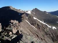
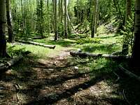
![Kings-Emmons Ridge]() Looking back at the first 4 peaks on the ridge
Looking back at the first 4 peaks on the ridgeOverview
According to
Scott the
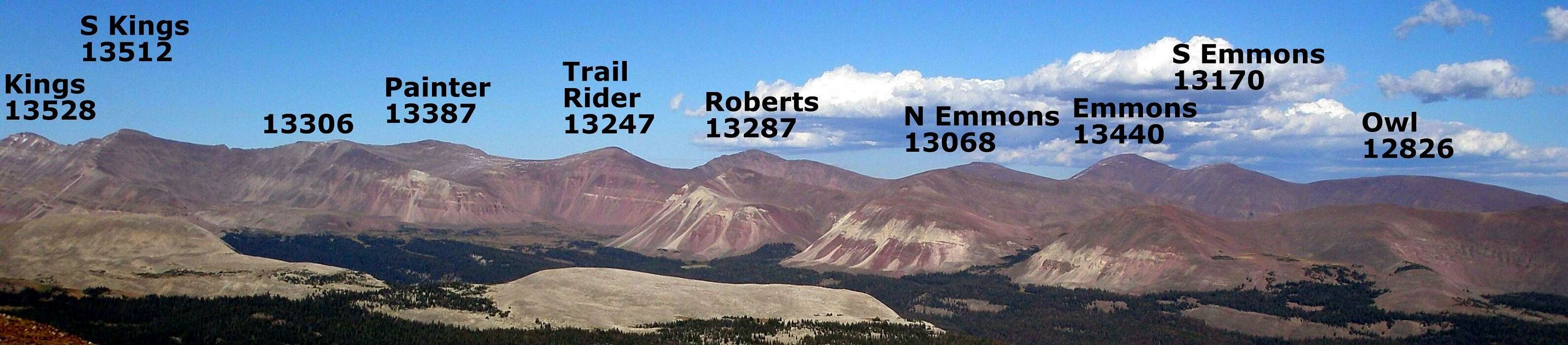
Kings-Emmons Ridge is the highest continuous ridge in Utah and one of the highest in the United States. For a backpacker, the recommended time to complete a ridge run, car to car is 4-6 days.
![]()
The Kings-Emmons Ridge |
It was on my mind for over two years. Start at Henrys Fork Trailhead on the north slope of the Uinta Mountains, hike to
Kings Peak, Utah's high point, hike the whole ridge from Kings to Emmons, hit South Emmons and then Owl, and exit some place on the south slope of the Uintas. The hike would be in the 30 mile range with over 8000' of elevation gain, 5000' of which would be above 12500'. I would climb eight 13000 footers and one 12000 footer. I was planning to do it in a day.
I for sure had my doubts. In the climbers log for the Kings-Emmons Ridge, there were 4 entries, only
one of which reported successfully climbing all the peaks in the ridge (although it is not clear if S Emmons was included).
Grizz and Fred had spent 19 epic hours climbing the ridge in a loop trip from a base camp in Painters Basin. I was hoping for 20 hours car to car. I figured 6 hours to get to the top of Kings, 7 to get to Emmons, and then another 7 to get out. I wouldn't have the overhead a base camp would entail. Also, they did it on snowshoes and encountered "horrible collapsing snow". I am well acquainted with the horrible collapsing snow conditions of spring time in the Uintas where you posthole to your knees while wearing snowshoes and was content to wait for the snow to be gone, hopefully by mid July when there would still be a fair amount of daylight. Still, the 19 hours these men took to go what I mapped out to be less than 15 miles certainly gave me pause. I had hiked with both of them and both were extremely fit.
I thought of the hike as having three distinct sections, Henrys Fork TH to Kings, Kings to Emmons, and Emmons out. The first section is very easy (relatively speaking of course) and I was quite familiar with it, having climbed Kings 8 times previously. The middle section was an unknown, and the last section was a big problem.
The Middle Section
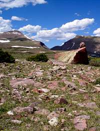
![Gunsight Pass and cairn]() Heading back to Gunsight Pass through Painter Basin Heading back to Gunsight Pass through Painter Basin
I wanted to do this hike in 2009 but had a lingering overuse injury caused by too much spring time snow shoe postholing in the Uintas and didn't think I'd make it too far but when I saw a day with a 0% chance of precipitation predicted I thought I'd have a go. Things did not go well and I knew I'd be turning around even before I got to Kings because my leg was already hurting. Never the less, I did the first 4 peaks (Kings, S Kings, Painter, and Trail Rider), climbing 3 new and hard to get, 13000 footers for me, and then descended to Painter Basin and hiked out, back to Gunsight Pass and the Henrys Fork Trail Head. |
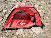
![What is it?]() What the heck is that? What the heck is that?![World s crappiest tent]() Why, it's the world's crappiest tent! Why, it's the world's crappiest tent!
After this experience I had no desire to do the whole ridge in one go the rest of that summer. However I did have a strong desire to climb every 13000 footer in Utah so I made another trip from the Swift Creek TH on the south slope to climb Roberts and North Emmons in the middle of the ridge. On previous trips I had already climbed Emmons, S Emmons, and Owl on the south end of the ridge. |
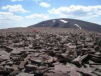
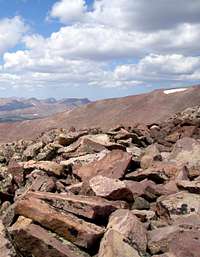
![Boulders and lots of them]() Lots and lots and lots of boulders Lots and lots and lots of boulders
Now I knew exactly what the middle section would be like, seven miles of boulder hopping. I had hoped for some easy walking tundra in the more gentle sections, but that high up, there was almost none to be found. There were very few places where any dirt could be seen between the rocks. In the flatter sections, the boulders were usually obviously stable and you didn't have to be so careful, but in the steeper sections there were many times when the boulders shifted underfoot and it was hard to go very fast, but surely, I could average 1 mile an hour over 7 miles from Kings to Emmons. |
The Big Problem
![Swift Creek]() Swift Creek stream crossing Swift Creek stream crossing
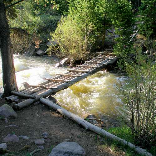
There is no easy way to get to Mount Emmons. I scouted out three different routes from the south slope and didn't like any of them. The first and fastest was a completely off trail route from the Swifts Creek TH. It was a tough route, much harder than climbing Kings Peak, and involved a significant bushwhack that I didn't want to tackle at the end of a long day. The second was via the Swift Creek Trail and the Buffalo Creek drainage. Even though this route employed 4.5 miles of trail out of 10 (one way) it still involved a significant bushwhack and a very difficult stream crossing. Again, not the best way to end a long day. The third was via the Uinta River Trail and was by far the most straight forward. A well defined trail takes you all the way to treeline and then you just head for the summit. The main problem with this route is that it did not go over South Emmons and Owl and I wanted to include those peaks too. The second problem is that there were many blowdowns across the trail. However, I did it very late in the season (November 9) and it is possible that the blowdowns are cleared on a yearly basis. |
There was one other route that I hadn't tried, Scott's
Dry Gulch Route. Scott had these choice words to say about it.
The trails marked on the map bear no resemblance to reality.
No marked trails.
You must be able to route-find.
Rather than trying to find any of the old trails marked on the map, we found it easier to route-find.
The trail is completely covered by fallen trees from a blow-down from a huge storm.
The going is pretty tedious.
Much boulder-hopping.
In addition, he says "Consider this trip to be the Uinta Mountains Ultimate Weight Loss Program!!" with not one, but two exclamation points. Good one Scott, I weigh 112. I can't afford to lose anything!
His description did not match what I was looking for, an easy way down from Mount Emmons. But, this spring I climbed Flat Top BM (12194') which is about the halfway point on the route. I varied it a little to make it more direct, but my way up matched Scott's experience and I was saying to myself "never again". Blowdowns were everywhere and when I would happen across a scrap of trail it wasn't worth following. In addition there were numerous boulders between the trees, not fun at all. But miracles do happen and on the way down I went a slightly different way that looked more clear of trees and stumbled upon a half decent trail which I was able to follow to the start. It was kind of disconcerting following it not knowing where it was going and I had lost my map early in the day which made things worse. But sure enough, it went exactly where I wanted it to, roughly paralleling my up GPS track, and I knew I had found my route down. But the trail wasn't very distinct and I knew I had to be out before dark or I wouldn't be able to follow it. In addition, there was more elevation gain than I had originally anticipated because now I would go over both Lost and Flat Top Benchmarks.
Logistics
As the crow flies, the two trailheads are only 22.75 miles apart. Sounds like not too bad of a car shuttle right? Well, by car the trailheads are about 200 miles away from each other by way of Vernal, Utah at the eastern end of the Uinta Mountain Range. The distance from our house in Salt Lake City to either TH is only about 150 miles.
The plan was for me to start at Henrys Fork TH, wear a Spot Satellite Messenger (SSM), and have my husband pick me up at the end of the Dry Gulch Road. The SSM would automatically send my husband a message every 10 minutes relaying my location. This way, he'd know if I decided to turn around, and if I hadn't, my approximate arrival time. Also, if I manually pushed a button, it would send a text message to his cell phone which he could check in Duchesne, about 2 hours away from the trail. And, if I encountered some unexpected difficulty and wound up at a different unplanned trail head, hopefully he'd be able to figure this out and I wouldn't be stranded.
The problem with this plan is that I had no way of knowing for sure if the messages were showing up. However after using the SSM for over a year we were confident in its reliability, but still, when you don't get any feedback there is always some small doubt. The start TH, Henrys Fork, is really busy but the end TH at Dry Gulch on most days sees no one. It would be an absolute disaster if I arrived there in the dark, cold, wet, hungry, and exhausted and no one to meet me.
Davy Crockett (yes that's his real name)
A couple of days before the big event I happened upon this
trip report by ultra marathoner Davy Crockett. Davy did an awful lot of complaining about boulders, all of which turned out to be completely justified. My thoughts were "Uh-oh, if it took Davy that long (about 20 hours), what does that mean for me? I don't plan on doing any running at all and I'm going to have a heavier pack and Davy is way bigger, way stronger, and way tougher than me." But, Davy hadn't gone out the way I was going to. I thought my way would be easier. Davy stopped at Mount Emmons and descended to Lake Atwood and then made his way over Trail Rider Pass and then Gunsight Pass and then back to the start at Henrys Fork. Although he came up with 48 miles, I mapped it out to be between 36 and 37, about 7 miles longer then what I was planning.
Joseph Bullough
Normally when I hike to a remote area I wonder when the next person might come along. This time I didn't have to wonder. I knew exactly. It would be tomorrow.
Joe was planning on doing a Kings-Emmons traverse the very next day. Ideally we would have combined forces, but Friday was better for him and Thursday was better for me. Also, he was going to go the way Davy had gone, exiting the ridge at Mount Emmons and I had my heart set on a complete north to south traverse. The ridge doesn't just end abruptly at Mount Emmons, it keeps going, and I would too.
Getting There
We have two cars in our family, a nice reliable all wheel drive Subaru Legacy and a piece of crap 15 year old Saturn. Usually I get the good car and my husband is content to micromanage the Saturn so that it doesn't boil over. The Dry Gulch Road has many seriously rough spots so we needed to save the Subaru for that which meant I had to drive the piece of crap Saturn to Henrys Fork. My husband gave me very careful instructions about how to cycle the AC on and off to get the fan going to prevent overheating. I was worried. I envisioned being one of those poor people you see on the side of the road with the hood up and steam pouring from their car. He said he checked the oil and when asked how low it was replied "two quarts". I gasped. We had had a
very unfortunate episode with the Subaru being driven with no oil in it whatsoever requiring a complete new engine and I sure didn't want to repeat that. But, by carefully looking at the temperature gage and cycling the AC as needed about every 4 minutes, I arrived at Henrys Fork car intact.
The other bad thing about driving the Saturn is that it has no mp3 or cd player and its tape deck has long been defunct. I couldn't even listen to
the song.
The other car issue was that ideally we would have had a high clearance vehicle for the Dry Gulch Road. When I had driven it in June in the Subaru on my Flat Top trip my teeth were clenched and I was hyperventilating the whole way down. The previous summer I had two separate exhaust system incidents and I wasn't looking forward to coming home and telling my husband "Oops, I did it again." But on this trip, that road was my husband's problem and I wasn't going to worry about it. Note that on a USGS topo map, the Dry Gulch Road is marked in the same style as the 50 mph superhighway A-1 prime dirt road to Henrys Fork, the best dirt road I have ever driven on.
Mosquitoes
There are a lot of mosquitoes on the north slope of the Uintas. (The last sentence should be in all caps.) Last year when I did the first 4 peaks on the Kings-Emmons Ridge, I slept in the car the night before. When I arrived at the trailhead I had cracked the windows slightly thinking "there's no way the mosquitoes will get through cracks so small". I went to the bathroom and when I came back the inside of the car was swarming with them. I killed as many as I could but every time I dozed off, was awakened by their annoying buzz. Finally it got cold enough so I could open the windows all the way so they could find their way out without more coming in.
After hiking I got back to the car just before 9pm and spent another night at the TH. This time I thought I was prepared for the mosquitoes which were swarming all around the car. I would not open the windows until it cooled off. I consciously thought about how I would open the door, jump in, and close the door quickly before any got in. It didn't work. A ton got in anyway and I had another miserable night.
This year I was smart and brought a tent. I planned to get up at 11PM and start hiking at exactly midnight. At 5PM I tried to nap and after not too much success finally got some real sleep at 9:30PM for 1.5 hours.
The Big Day
![R.I.P.]() R.I.P. R.I.P.
I got up at 11PM, ate a bowl of cold cereal with milk, packed up and walked to the TH to sign in. It was a few minutes before midnight so being overly obsessive I sat down on the picnic table at the start and waited. At exactly midnight according to my GPS I took off and became an eating machine. Every time food crossed my mind I would shove something else in. I ate a banana, 3 cold scrambled eggs, some cheese, a granola bar, and then I started on the bag of cookies and would have eaten them all except I dropped a few in some horse poop. I ate as much as I could because I knew that later in the day at higher elevations I wouldn't feel like it.
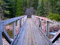
I made it to the turn off for Alligator Lake in 48 minutes and Elkhorn crossing at 1:50. Things were going great. Then I had a really big problem as I couldn't find the bridge over Henrys Fork in the pitch black. I had a waypoint set right in the middle of it but it wasn't there. I looked down stream, I looked up stream. I went back to the sign pointing to the bridge wondering if I had gone down the wrong trail. I made sure my headlamp was on the brightest mode and I scanned up and down the stream. I just couldn't believe it was actually gone, washed away in the spring runoff without a trace. I was a very sad puppy. But then I remembered reading in an SP forum the reports of two people who had recently summitted Kings and neither had mentioned anything about any unexpected stream fording so I looked again and found two crummy logs over the stream that looked very wet and slippery so I got down on my hands and knees and crawled. They are sitting just inches above the current water level so they are sure to go next spring too. Now if it hadn't been dark, the way across the stream probably would have been more obvious, but it cost me 14 minutes of floundering to get across.
Next up was the muddy morass. Anyone who has climbed Kings via Henrys Fork in June or early July knows exactly what I'm talking about. If you stick to the trail you will be ankle deep in thick oozy mud. If it is daylight you can look ahead and pick the best way across. But at night with no moon at all, I just did the best I could and decided I'd rather fight my way through willow brush than have wet feet the rest of the day.
I'd hoped to get to Gunsight Pass in 4 hours and I thought I was still on track to do that. However, since it was dark I couldn't judge how far away I was and the terrain was way grassier than I thought it should have been and I was worried I was still in the marshy section. I was afraid to pull out my GPS and look. I encountered a steep rocky uphill and I knew I was almost there. At the top I looked back and saw some headlamps heading up and I hoped whoever it was would hurry up and pass me so I'd have someone to follow, but no such luck. I kept looking back as I cut across the base of West Gunsight, but I never saw the headlamps again. I headed directly to the base of Kings skipping Anderson Pass. This section was particularly hard for me to navigate in the dark without a distinct trail to follow. In the daylight it is easy. |
I had started out the day with one full 20 oz water bottle and now it was time to fill up at the stream at the base of Kings. I guzzled as much as I could and then pumped 20 oz + 32 oz. I had wondered what it would be like pumping water in the dark when the temperature was in the 30's. I was right, I was uncomfortably cold and my hands were freezing. I couldn't wait for the sun to come up and by this time the faintest glow was to the east. I was hoping my 52 oz of water would last me until I reached a small lake on the other side of Flat Top, almost 15 miles away. It seemed a bit skimpy, but I reasoned that if I was running low I could always add some snow to it.
![]()
5:52AM |
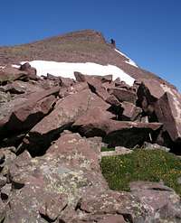
![South Kings Peak]() Early morning light on S Kings Early morning light on S Kings![S Kings and Kings]() Looking back at S Kings and Kings Looking back at S Kings and Kings
Now was the steep ascent up the side of Kings. In order to make it there by 6am, I had to climb 1000' in 45 min to an elevation of 13528'. As I was approaching the top, I watched the sun rise. It was beautiful. I had never seen the sun rise from so high up. I made it there just before 6, took a few pictures of South Kings and kept going. There was no time to sit on the summit and enjoy the view. Perhaps a little too compulsively, I just had to stand on the top of every little bump on the way over to S Kings. This compulsion would wear off as the day wore on. This section was a straight forward boulder hop on mostly stable rock.
Hundreds of people climb Kings Peak every year since it is Utah's high point. A few of these go on to climb South Kings, but almost no one ventures any further down the ridge.
|
![Painter Peak]() Painter Peak with the long line of snow Painter Peak with the long line of snow
After S Kings comes 13387 foot Painter Peak with a small bump, 13306', along the way. Between 13306 and Painter Peak is a fun section where it is flat on top with steep sides punctuated with 10' deep fissures. Most of these are easily stepped across but some required taking a deep breath and jumping. Most of the way, however, was boulders and more boulders. I was still pretty cold but kept telling myself "It will warm up soon."
|
![Trail Rider Peak]() Trail Rider Peak on right half Trail Rider Peak on right half![Yellow Benchmark]() Garfield Basin from Trail Rider Peak Garfield Basin from Trail Rider Peak
After Painter Peak is Trail Rider Peak (13247'). This stretch was easier than what I had already done because there was some actual dirt for a stretch and the rocks were flatter. I reached the top of Trail Rider Peak at 9AM, right on schedule. This was where I turned around last year. There was no way I was doing that this year. In preparation I had carefully studied a map and noted every single possible place I could bail off of the ridge and had a ton of waypoints loaded into my GPS. None of these bail options would be used. |
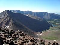
![Roberts Peak]() Roberts on the left, Emmons, S Emmons, Owl in the background Roberts on the left, Emmons, S Emmons, Owl in the background
Next came peak number 5 13287' Roberts Peak. This section was the toughest as it was the steepest and the boulders were the shiftiest. Once I made it over this peak things would get easier. I was pressed for time and did not have the luxury of taking breaks on any of the summits. Any breaks I took were only when I needed to pause to refresh my energy for the ascents. I would get to a summit, go over the top down to the next saddle and go part way up the next peak until I needed to stop and then I'd sit down for a while and force myself to eat. It was so windy that whenever I'd open my mouth my hair would blow in and I'd have to pull it back out. The views were just as good half way up a peak as they were from the very top. Sometimes the views were even better than on top because some of the summits are flat. |
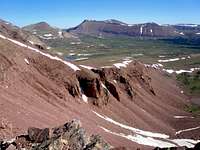
![Timothy Lakes Basin]() Timothy Lakes Basin Timothy Lakes Basin |
![Timothy Peaks]() Timothy Peaks Ridge Timothy Peaks Ridge |
![Gunsight Pass]() Looking back to Gunsight Pass Looking back to Gunsight Pass |
![North Emmons]() North Emmons (13068') North Emmons (13068')
After Roberts comes an easy one, North Emmons. Descending Roberts was a bit slow, but it is a very gradual uphill to North Emmons, 558 feet spread over a mile. Having done this section last year, I knew the footing was the best there was on the whole ridge, yet I could feel the hot spots forming on my feet. North Emmons is much more interesting when viewed from the south than the north because of its distinctive pinnacle which is more prominent from this direction because behind it is blue sky instead of its blending into Mount Emmons. But, when I look at this picture, I don't so much look at the pinnacle as I do at the uneven jagged rocks in the foreground which made up the footing for much of this trip. No matter how fit you are, there is a limit to how fast you can travel in such terrain. |
![Mount Emmons]() Emmons Emmons![Flat Top?]() Could have been named Flat Top Could have been named Flat Top
Finally it was time for Emmons. This was what I had been dreading all day, a sustained up hill of 853 feet from 12587 to 13440 after already putting in 6500 vertical feet and 17.8 miles. But, it wasn't as steep as elsewhere and there was a very welcome snow patch in the middle. It was so much easier picking my feet up a few inches and shuffling them forward then to pick them up a foot or so to step up and over a rock. I made it to Emmons a few minutes before 1pm, 13 hours after starting out. Emmons is very flat on top and has a small summit cairn and a crumbling benchmark disk just S of the cairn. The forecast had called for a 0% chance of thunderstorms and to the north there was not even a single cloud. To the south there were just two tiny ones on the horizon. This is a very rare sight indeed for an afternoon in the Uintas and I'd be surprised if it happens again this summer.
From Emmons, I was hoping to average 2 miles an hour over the remaining 12 miles and be out by 7pm, but I knew that was optimistic. As the day wore on I was hoping for 8pm and finally I just wanted to be out by dark. |
![Lost and Flat Top Benchmarks]() Lost Bm on the left and Flat Top BM on the right Lost Bm on the left and Flat Top BM on the right
I had been on the stretch from Emmons to the far side of Owl 3 other times, but they had been earlier in the year and there had been a 10' swath of snow on the east edge of the ridge enabling me to skip most of the boulders, not so today. It was boulder after boulder after boulder. I went down Emmons and up South Emmons, down South Emmons and up Owl. Even though the grade was much gentler now it was still hard to go very fast. I went part way down Owl and then I was into new territory. I veered east along the ridge headed for Lost Benchmark. It was only 149' up to the top, but it felt like 1000. I could have easily skirted both Lost and Flat Top, but what would be the fun in that? None of the other peaks are convenient to skirt.
Flat Top Benchmark is aptly named. But, N Emmons, Emmons, S Emmons, Owl, and Lost Benchmark could also share that name as they are all flat on top. Flat Top is striking because there are several distinctive bands of white rock running across its base. All the other rock in this area has a red tint and this was the only white rock I had seen all day. But alas, white rock is no easier to walk on then red rock and it seemed like it took forever to get to the top. I wondered if I could possibly be in trouble timewise. Even though there were many splashes of green now between the rocks, it was still rocky and not the easy going tundra I had hoped for. But finally, after 17.5 hours I was there, on top of the last peak of the day. I was very, very happy.
|
Almost All Downhill
I reached Flat Top at 5:30PM and now it was all down hill (almost) and I thought it would go fast, but had forgotten about the boulders to descend on the south side. Finally the rocks ended abruptly and I hit a nice grassy slope. It was time to look for water. My 20 oz bottle had lasted all the way from the base of Kings to Emmons. It had warmed considerably past Emmons so the remaining 32 oz was almost gone over a shorter distance. I never had to add any snow to it. The first small gully I tried was dry but the second was flowing nicely. It's a good thing, because if the small streams were no longer flowing I had planned to fill up at the small lake shown on the left below.
![Flat Top Benchmark]() June-18-2010
June-18-2010![Lake?]() July-15-2010
July-15-2010
But when I got there it was a dry meadow as shown on the right. I couldn't believe it. I thought "Where's the lake?! Am I that bad at navigation?" Then I saw the tell tale dead tree. What was amazing was that the ground was completely dry, not muddy or soggy at all, and the vegetation that had been underwater looked in great shape.
![Lily Pad Lakes Trail]() The trail to the Dry Gulch Road The trail to the Dry Gulch Road
I found the trail easily and breathed a huge sigh of relief. After the lake snafu I was a little worried. The trail is not shown on any map and starts out as a series of cairns through an open area and gradually becomes more distinct as it approaches the trailhead. I was glad I had done it before as it was much easier to follow now, but I still lost it in a few places but quickly found it with the help of my old GPS track. It descends to the western most corner of Lily Pad Lakes and then climbs 200 feet over a ridge to a huge meadow on the other side. After this, it is a pleasant walk in the woods to where it joins the old road to Heller Lake about .8 miles from the start.
The south slope of the Uintas is considerably drier than the north slope and hence far fewer mosquitoes. Even though it was evening when they are most voracious, the only place I noticed any at all was around Lily Pad Lakes and then it was maybe 1 every 5 seconds instead of 10 every 1 second.
A quarter mile away from the trailhead I encountered the biggest elk I had ever seen with a gigantic rack. It crashed through the brush and I wondered how it could thread the trees so quickly with those huge antlers sticking out. Shortly, I heard a "woof" from my husband who was heading up the trail to meet me worried I had been trampled as the elk had run right in front of him, obviously spooked. We got back to the car a few minutes before 9 for a total of just under 21 hours. Whew! We left immediately so we could get over the rough road while it was still light. I took my boots off as we drove. Oh did that feel nice. I had a huge blister on the sole of one of my feet but other than that just felt very, very tired. I had not seen a single person the entire day, except for the headlamps in the distance near Gunsight Pass and my husband at the very end.
|
Stats
Elevations are in feet.
Elev Elev Running
Miles Loss Gain Time
Henrys Fork TH (9420) to Kings Peak (13528) 11.49 0 4108 5:56hr
Kings to S Kings (13512) .80 488 472 6:57
S Kings to Painter Peak (13387) 1.52 540 415 8:19
Painter Peak to Trail Rider Pk (13247) .96 502 362 9:03
Trail Rider Peak to Roberts Pk (13287) .85 503 543 10:19
Roberts Peak to N Emmons (13068) 1.72 817 598 11:49
N Emmons to Emmons (13440) 1.15 481 853 12:58
Emmons to South Emmons (13170) .73 540 270 13:49
South Emmons to Owl (12826) 1.12 605 261 14:46
Owl to Lost BM (12391) 1.86 584 149 16:01
Lost to Flat Top BM (12194) 1.89 651 454 17:32
Flat Top BM out (8720) 6.22 3674 200 20:56
----- ---- ----
30.31 9385 8685Apples and Oranges
![Atwood Basin]() Atwood Basin Atwood Basin
At the beginning I said that the recommended time for a backpacker, car to car was 4-6 days. I don't think that is unreasonably long. It is much more difficult to keep one's balance over boulders carrying a heavy load, not to mention it's a lot harder to go uphill. And, 4-6 days will give you plenty of time to rest and enjoy the scenery.
If you don't want to mess with a long car shuttle and choose to exit the ridge at Emmons and return to Henrys Fork via Atwood Basin, then you save 1334 feet of elevation gain by not going over S Emmons, Owl, Lost, and Flat Top and skipping the ascent from Lily Pad Lakes. However, you have to climb out of both Atwood and Painter Basins for a combined elevation gain of roughly 1400'. But you'd be climbing at lower elevation, most of the way on a trail or through low vegetation vs boulders, so even though it is slightly more, it's probably easier. But, you'd have a very steep, rocky descent of Mount Emmons, heading generally towards Allen Lake, that I can't imagine going too fast, not to mention the 7 extra miles of total distance.
|
![Still there?]() Still there? Still there?
If you don't mind exiting the ridge at Emmons and don't mind a big car shuttle, then I think the easiest way to end the hike is to descend east from Emmons, passing south of Oke Doke Lake to the Uinta River Trail. It is about 13.5 miles from Emmons to the TH and the trail is pretty good except for the blowdowns, but, it looked like a popular trail so there is a good chance they will be cleared. Hopefully, when you get to the bridge across the Uinta River, it will still be there. |
The Ultimate Utah Ridge Run
![Henrys Fork Peak and Cliff Lake]() Henrys Fork Peak, Kings, and S Kings from Mount Powell
Henrys Fork Peak, Kings, and S Kings from Mount Powell![North ridge of Mount Powell]() Easy walking tundra on the way to Powell
Easy walking tundra on the way to Powell
Here's what I think the Ultimate Utah Ridge Run would be, just like the hike described except that instead of getting to Kings Peak the easy way, go over Mount Powell and Henrys Fork Peak to get there. It's about 2.5 miles farther and about 1300' more of elevation gain. The terrain is rougher and the trail half way up Powell from the Dahlgreen trailhead is hard to follow. There isn't any water on the ridge once the snow is gone so unless you wanted to carry all of your water with you, you'd have to descend from Anderson Pass until you found some. There is some good news though. The north ridge of Powell is very easy walking tundra for the most part and is incredibly gentle. It doesn't get rugged until close to the summit. But then there is some solid class 3-4 scrambling to get to Henrys Fork Peak. Good luck! You're going to need it and if you don't think you can do it just play
the song.
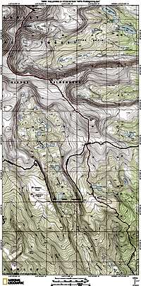
Topos
![The Beginning]() The beginning The beginning | ![The Middle]() The middle The middle | ![The End]() The end The end |


Comments
Post a Comment