
-
 8611 Hits
-
 71.06% Score
-
 1 Votes
|
|
Route |
|---|---|
|
|
46.38730°N / 11.72470°E |
|
|
Scramble and Ferrata |
|
|
Most of a day |
|
|
Easy Ferrata |
|
|
Approach
See the Getting There info on the Main Page. For a day trip Malga Crocifisso in Val di San Niccolò is the best starting point.Route Description
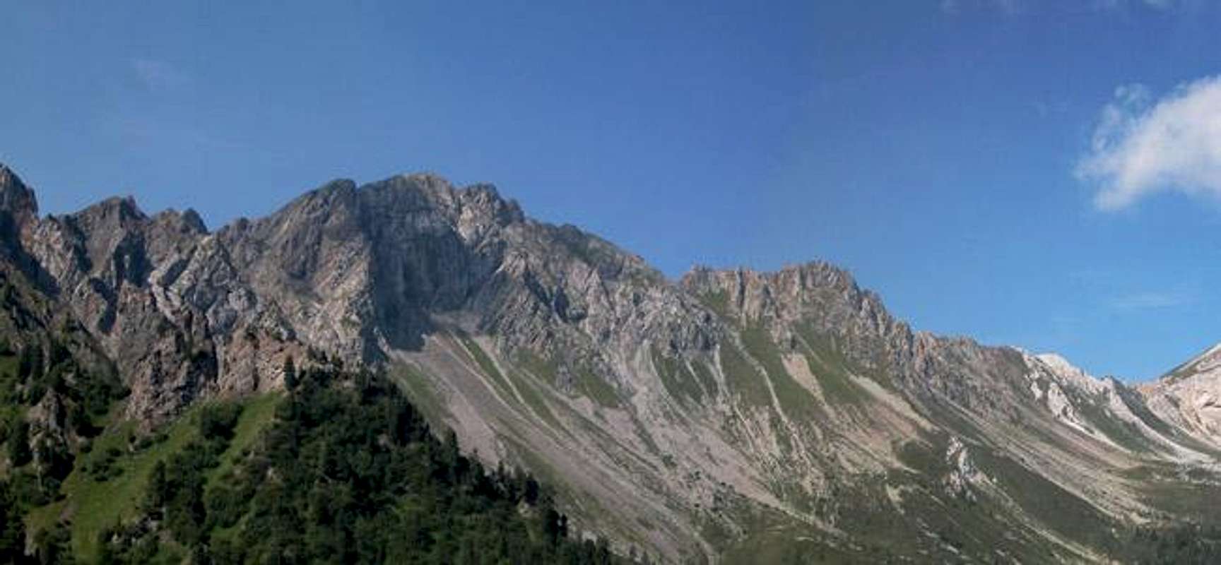
R i z z o n i C r e s tSpiz di TariciognCima RicolettaSpiz di MalinvernMunciognPunta della ValciaSas da le UndeshSas Morin
 |  |
- Start altitude: 1552m
- Summit altitude: 2647m
- Prevailing exposition: N (ferrata from Passo delle Selle)
- Type: 5h on trails, 4h scramble and ferrata
- Protection: strong fixed cables along the Rizzoni Crest
Th Alta Via Bruno Federspiel is an easy ferrata or "Sentiero Attrezzato" (equipped trail) which winds across the whole Monzoni Ridge. Starting points for the ferrata are Passo delle Selle (east) or Forcella la Costella (west). Most of the times the Alta Via is climbed from east to west, due to the easier access to Passo delle Selle. You will find several sections here, including ascent and descent from and to Malga di Crocifisso in Val di San Niccolò.
Access: Malga di Crocifisso - Passo delle Selle
This first stage leads through Valle dei Monzoni, a southern side valley to Val di San Niccolò. The lower parts of it are very popular among the picknick crowd, so expect to meet a lot of people. The main reason for the popularity are the many Malghe and Rifugios, which are all aligned along the valley.Valle dei Monzoni turns southward at Malga di Crocefisso. After about 500m the road is closed with a small parking lot at its end. From here shuttle buses can take you to Malga Monzoni right in the middle of the valley. You better use this offer because otherwise you'll be hiking a dirt road with a shuttle bus racing by every 10 minutes.
After Malga Monzoni the road ends in a trail intersection. To the west (No 624) you can reach Forcella la Costella, the southern trail (No 603) leads to Passo delle Selle. Half an hour of beautiful forest trails take you to the neat Rifugio Taramelli, a small cabin built on to of a limestone rock. Very nice to behold.
From Rifugio Taramelli a steep scramble leads up to Valle delle Selle, a high valley which ends in Lagho delle Selle at its bottom. The lake is very small and it didn't hold any water in late July anymore. From the lake the trail crosses over to the norhern side and leads along the slopes of Pala di Carpella up to Passo (and Rifugio) delle Selle.
 |  |  |
Stage 1: Punta delle Selle and Punta Allochet
From Passo delle Selle on you are on the Alta Via Federspiel (no 616). It runs along the crest, mostly on the WW I supply routes northern side. Here you find a lot of old WW I positions with explanations about the war history. While at first harmless, the ridge gets steeper as the first summit, Punta delle Selle comes in sight. Sheer drops toward Valle delle Selle develop to the north while to the south you find steep grass slopes.Punta delle Selle gives a good overview about what is yet to come - an easy ridge traverse to Punta Allochet and afterwards the scramble across the Rizzoni, Malinvern and Munciogn summits. Between Punta delle Selle and Punta Allochet the Alta Via roughly keeps the same height with little bumps and cols in between.
Directly after the Allochet summit you will find the first fixed cables - deployed along a steep slab. This is one of the two cruxes of the ferrata. People with short legs will have difficulties negotiating it. To the west of Punta Allochet you come across the last of the WW I positions, the only one actually located on the south side of the ridge, overlooking Valle di San Pellegrino.
 |  |  |
Stage 2: Rizzoni Crest
At this stage the ferrata part of the Alta Via Federspiel starts. Exposed sections follow each other, but all are equipped with strong and firm cables. The trail runs along the northern side of the crest, through the north faces. It climbs rapidly to about 20m below the crest where it keeps altitude for a while, touching most of the passes between the summits. Whenever it reaches a pass you are offere great views of the near vertical drops into Valle di San Pellegrino below.After a shallow section directly on the ridge the trail switches sides and climbs toward Spiz di Tariciogn from the south. This is steep grass scrambling with almost no protection. Also finding the path was not easy - it was hardly recognizable in late July. Some sections are very steep running through grass covered chimneys. Once back to the ridge the summit is easily reached but the descent ino Forcella Ricoletta is kind of hazardous. No protection, sheer drops to the north and lots of scree on the trail. An indication of things to come...
 |  |  |
Stage 3: Spiz di Malinvern
From Forcella Ricoletta you follow directly the ridge to Spiz di Malinvern. Easy to find, but very steep and always negotiating directly above the Malinvern north face. Cima Ricoletta, a side summit to Malinvern is reached, from where the main summit can be seen and easily reached.In case of a sudden weather change you can leave Spiz di Malinvern along the southwestern ridge, the Pale Rabbiose. At first an easy stroll along grassy hills, this gets to be a very chossy emergency exit as you get further down.Again, like on Spiz di Tariciogn the descent of Spiz di Malinvern is hazardous. There are four rappelling anchors to the west of the summit, meant to negotiate a 30m section which cannot be protected otherwise. Without a rope you have to tread ultra carefully. One false step and you'll find yourself several 100m below.
 |  |  |
Stage 4: Munciogn and Vallaccia
The final stage of the Alta Via Federspiel is the traverse of the Munciogn ridge west of Spiz di Malinvern. This ridge consists of a multitude of towers, stretching from Malinvern to Forcella la Costella. Once in the col west of Malinvern the trail turns to the south of the Munciogn towers and crosses some steep grass slopes. Again, like on the Rizzoni Crest you will come across quite a number of steep chimneys and the trail cannot be easily found.Once west of the last tower the trail climbs back to the ridge which it follows to its final destination at Forcella la Costella. In case you have enough energy you can climb Punta della Vallaccia from the Forcella, which can be done in 30 minutes and covers 100m in elevation gain. The views may be worth the climb - we didn't go there because we just wanted to get back as soon as possible.
 |  |  |
Stage 5: Descent from Forcella la Costella
From Forcella la Costella the trail (no 624) again is marked very well. However the first 500m are rather difficult. You traverse the scree slopes beneath Punta della Vallaccia, which are as steep as scree slopes get. Take care not to tread loose any rocks. Once beyond the Punta della Vallcia wall the trail heads for Rifugio Vallaccia and on to Malga Monzoni. The descent is long and tedious - beyond Rifugio Vallaccia it turns into a dirt road.Again I would recommend to use the shuttle bus from Malga Monzoni, the reasons being the same as given in the first section.