

gordonye - Oct 5, 2001 9:47 am - Hasn't voted
beautiful terrain mapVery nicely annotated too. What software did you use? Is it not an off-the-shelf product? :)

mpbro - Oct 5, 2001 11:21 am - Hasn't voted
Re: beautiful terrain mapHi Gordon,
The USGS used to distribute the DEM (digital elevation model) data freely. I downloaded the data, then eventually converted it to a TIF image, using the hacking described on my Topo page. From there, I read the map into Matlab and display it in 3-D.
But you're right, to make these maps requires some extra work. First, I had to warp the DEM data to a rectangle, as the raw data is roughly a rhombus on a cartesian grid. I use a simple affine transformation, where the control points are picked automatically.
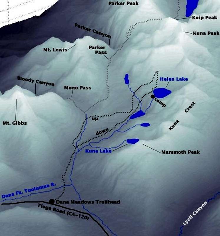
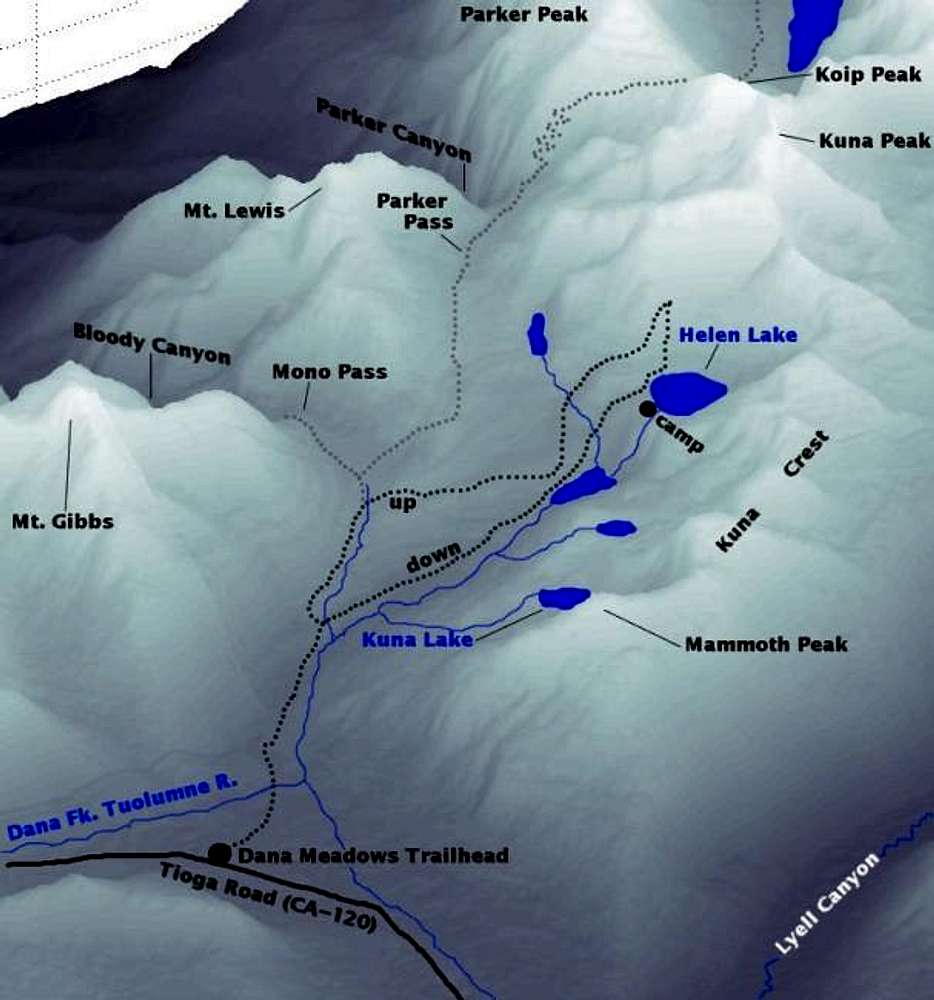
Once maps are on rectangular meshes, I can splice them together into mosaics, with some error at the edges, of course. I believe the map that you commented on was a mosaic of the Vogelsang Peak, Tioga Pass, Mount Dana, and Koip Peak 7.5-minute quads. I zoomed in a bit, since the area of interest is roughly on the 4-corner-point of these maps.
To make the elevation maps into shaded relief maps, I compute a east-to-west derivative (convolution with [-1,1] finite-difference filter). To keep the relative elevation information intact, I use the following formula:
output = elevation + c*derivative
In general, c=0.1 seems to give a pleasing map. If I was working with 32-bit color, I could play games with alpha channels, but I am working with 8-bit color...
Lastly, to annotate the maps, I dump from Matlab to TIF, then process using "The Gimp", which is a free photoshop clone for UNIX.
Very labor intensive, but I enjoy wasting time making these silly maps! :)
-Morgan
gordonye - Oct 6, 2001 12:55 pm - Hasn't voted
Re: beautiful terrain mapAnd you didn't mention the draping of streams, lakes, and your routes on top of the terrain, or did you just hand draw them? :)
I have played with the topo! software that drapes the USGS topographic maps (with contours and landscape features) onto 3D perspective, and you can draw your routes on it too; however, the results are not the prettiest sometimes, but it takes almost no work.
I work with GIS (geographic information systems), so I have played with DEMs a lot. I have some 3D maps at http://www.webbnet.com/~gordonye/graphics.html (bottom of page), created with Arc/INFO GIS software. The good thing is that the software handles sun angle, shading, draping, etc., I just need to set the colors, parameters and decide what layers to drape on. It's still labor intensive.
Any way, you did some good work. I think the way you slanted the text to fit the prespective is pretty neat. The grayshade terrain also make the routes and text stand out nicely. I've seen some hiking guidebooks showing pretty low-quality, pixelated hillshades, so it's cool to see some very nice work here...
mpbro - Oct 8, 2001 11:04 am - Hasn't voted
Re: beautiful terrain mapI hand draw the trails, lakes, streams, and glaciers on the maps. In some cases, there is less guesswork than you might think, like when the stream sits in a narrow canyon.
Also, lakes tend to be pretty easy to find--as they are flat, any spatial derivative across a lake is zero. This might form the basis for auto-detection of lakes, but since the DEM's have limited resolution, both in space and in elevation, many flat places that are not lakes might very well seem like lakes.
If I wasn't wasting my time in graduate school (geophysics, but not directly related to this kind of mapping) I would have more time to make maps. There is a lot of cool GIS software out there, but I know nothing about it.
I've actually looked into acquiring very high resolution topography data (using LiDAR) over peaks of interest to make hyper-accurate topo maps for climbers. The acquisition tends to be expensive...not sure I could sell enough maps to justify the costs. The best would be to write an NSF grant...if only it would help me graduate.
Thanx for the compliments, and keep posting your good stuff,
Morgan


Comments
Post a Comment