
-
 6161 Hits
-
 76.66% Score
-
 7 Votes
|
|
Route |
|---|---|
|
|
48.45330°N / 113.34343°W |
|
|
Scrambling |
|
|
Spring, Summer, Fall, Winter |
|
|
Most of a day |
|
|
Class 3 |
|
|
Moderate |
|
|
Overview
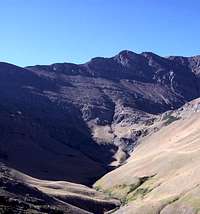
 A View from Mount Henry
Mount Henry sits at the head of Appistoki Creek and has an imposing face that rises over 1,700 feet above the valley floor.
Total elevation gained from the trailhead is 3,867 feet to the summit of Mt. Henry. To reach the summit of Appistoki Peak it is necessary descend 1,000 feet in elevation before gaining 500 feet again.
The Appistoki Creek route follows Appistoki Creek as it traverses below the 1,700 foot northern face of Mount Henry. In the early summer there are many wildflowers and beautiful waterfalls along this route.
This route also affords easy access to other peaks behind Mount Henry such as Ellsworth and Medicine Grizzly.
Getting There
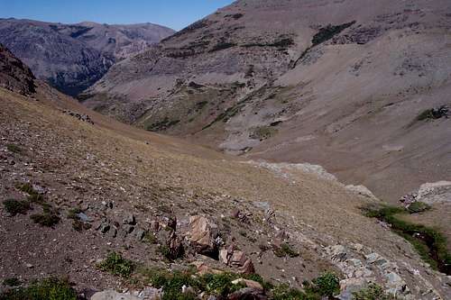
 Appistoki Creek
Glacier National Park, the crown of the continent, is located in northwestern Montana and shares a border with Waterton International Peace Park in Canada. The Scenic Point Ridge Walk is located in the Two Medicine Valley in the southeastern corner on Glacier National Park.
See the Mount Henry Main Page for Driving Instructions.
You can also visit the Mount Henry Main Page for information related to Red Tape, Camping, Recommended Equipment and other pertinent information related to visiting Northwestern Montana.
 Cushion Buckwheat
Volume Two of Climb Glacier National Park has details on Mount Henry and suggested routes. It can be ordered at Climb Glacier National Park.
Route Description
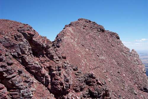 Mount Henry
Route Description:
TEXT IN CAPITAL LETTERS LINK TO ADDITIONAL PHOTOS OF THE ROUTE.
 Appistoki Creek Route from Switchback
From the trailhead enjoy a walk through trees while listening to Appistoki Falls. A short side trip on your return rewards you with a beautiful view of APPISTOKI FALLS. After breaking out of the trees and enjoying Appistoki Creek far below the trail reaches a switchback that yields views of part of HENRY'S NORTH FACE. This is the point that must be reached to begin a direct ascent of Appistoki and is also the desired point when descending back to the trail from Appistoki.
From the SWITCHBACK walk on the sidehill underneath a great ridge towards the basin below Mount Henry. Keep in mind that you will need to regain all of the elevation lost so try to stay on a set contour line as much as possible. Once the creek is met it will be necessary to cross it. There were multiple places to cross in August but earlier in the year could prove challenging depending upon the amount of snow melt feeding the creek.
 To the west from Appistoki Saddle
After crossing the creek head for the low saddle on the west side of Appistoki. This portion of the climb will be the most tiresome portion of the climb. After reaching the saddle the route to the unnamed peak to the west above the saddle is uncomplicated.
A Climber's/Animal Trail follows along the ridgeline to the unnamed peak that is shaped like a triangle. Summit it if desired or walk around the northwest side to the ridgeline that and continue to Mount Henry.
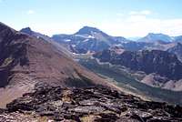
Descent from Mount Henry
 Looking down the route
Two Options Present for Descent from Mount Henry. Choose accordingly depending on time remaining for the trip.
Option A: Retrace route and Summit Appistoki Peak
To summit Appistoki back track and return to the saddle. Climbing Appistoki is an easy task as the ridge ascends 500 feet to the summit which sit at 8,143 feet above sea level. Take time and enjoy the views of Two Medicine and the bowl below Mt. Henry’s north face.
Descend from Appistoki to the switchback by choosing one of two options as outlined. Each route will return to the switchback.
Option 1) Descend the east cliffs of Appistoki to the streambed and follow its course along class 3 and 4 cliffs that are easily navigable to the switchback which is at 6,000 feet.
Option 2) Descend 500 feet on the north side of Appistoki to a ramp that slopes east until at the 6,000 feet contour and return to the trail near the switchback. Return to the trailhead via Scenic Point Trail.
Option B: Continue South on the Scenic Point Ridegwalk to the Scenic Point Trail and return to trailhead.
See attached map for approximate route. Basically it follows the ridge line to Medicine peak and then drops down the the ridge to the north which connects in with the Scenic Point Trail. The route to the trailhead needs no further explaination except make sure you follow the trail to the north!
Special Considerations
 Mount Henry
The rock in Glacier Park is widely varied and it is not unusual to find several different types of rock on any given route. Know your rocks and be certain of your safety. J. Gordon Edwards has an excellent section in his guidebook on rock and climbing safety. Be safe and know your limitations as well as those who are climbing with you. Also refer to the following links for further details: GNP Rock and Grading System and the GMS Climbing Guidelines.
External Links
Glacier National Park in PicturesGlacier Mountaineering Society
Two Medicine Trails
Visit Montana
Volume Two of Climb Glacier National Park has details on Mount Henry and suggested routes. It can be ordered at Climb Glacier National Park.