
-
 67655 Hits
-
 96.75% Score
-
 62 Votes
|
|
Area/Range |
|---|---|
|
|
46.51730°N / 11.81360°E |
|
|
10341 ft / 3152 m |
|
|
In Memory of Stefan "kletterwebbi" Weber
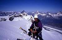 A note from the SP staff
Stefan Weber, the member we all used to know from his climbing pseudonym kletterwebbi, died on May 28th 2004 in southern France at the age of 37.
Stefan joined SP early on in 2002 and contributed a number of excellent pages and routes to this site. He was an accomplished climber excelling in difficult alpine and technical routes. The Dolomites, especially the area around Gröden / Val Gardena were special to him, as it was his old ancestral home.
kletterwebbi was always willing to share his knowledge and experience with other climbers, mainly here on SP, but also on other sites. He contributed his IT expertise as webmaster of his local section of the German Alpine Club, where he also engaged in leading trips for fellow members. Besides his climbing and mountaineering activities he was a musician, a composer of contemporary music. Stefan will be greatly missed by us all.
This page will be kept in honor of kletterwebbi, one of SP's most talented, knowledgeable members, and without a doubt, one of our greatest fellow mountaineers.
The picture was taken on the summit ridge of Lyskamm.
Overview
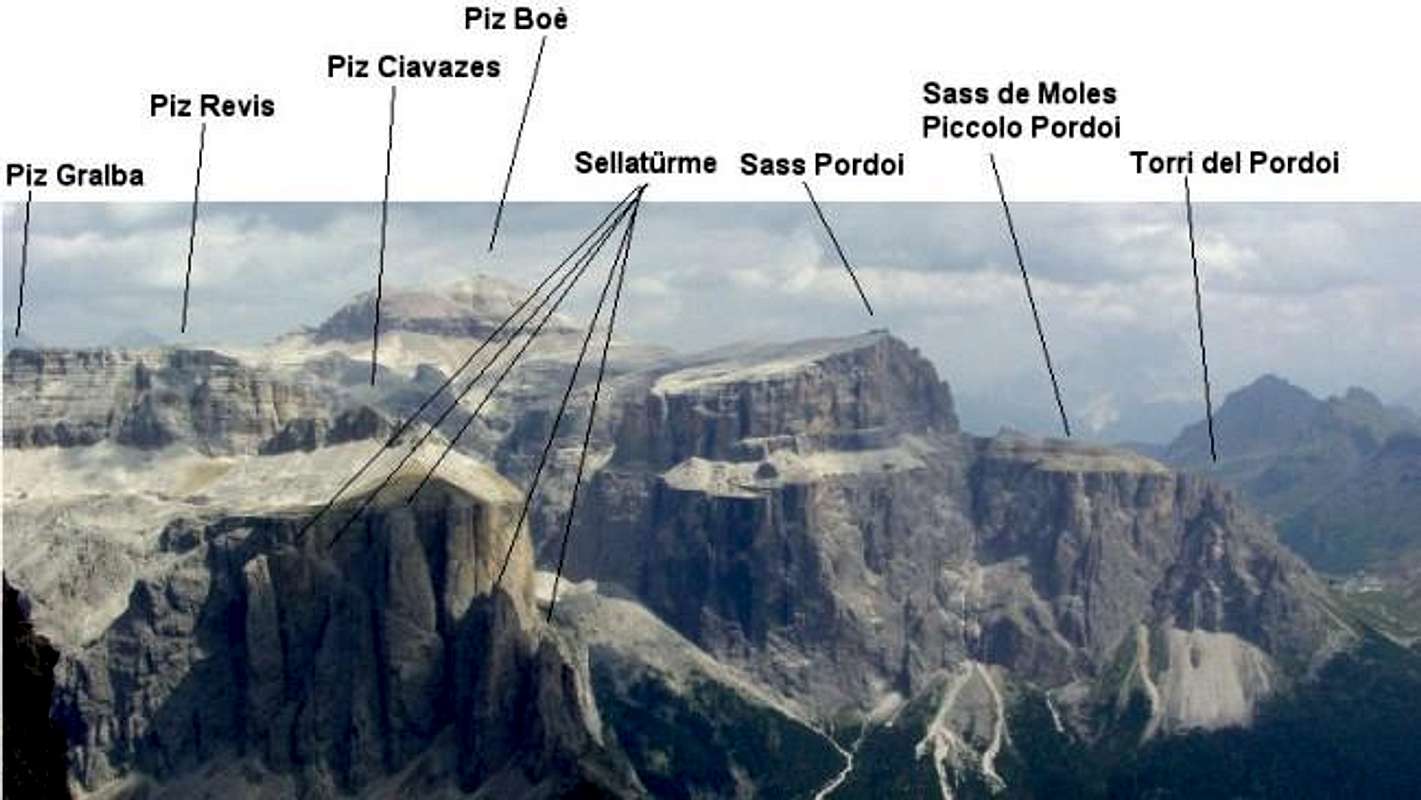
Crepa NeigraSella TowersPiz CiavazesPiz SelvaPiz LastiesTorre del SielaPiz MiaraTorre di RocesSass PordoiSass de ForciaPiz BoèPunta di SoèlPunta de Larsei
 |
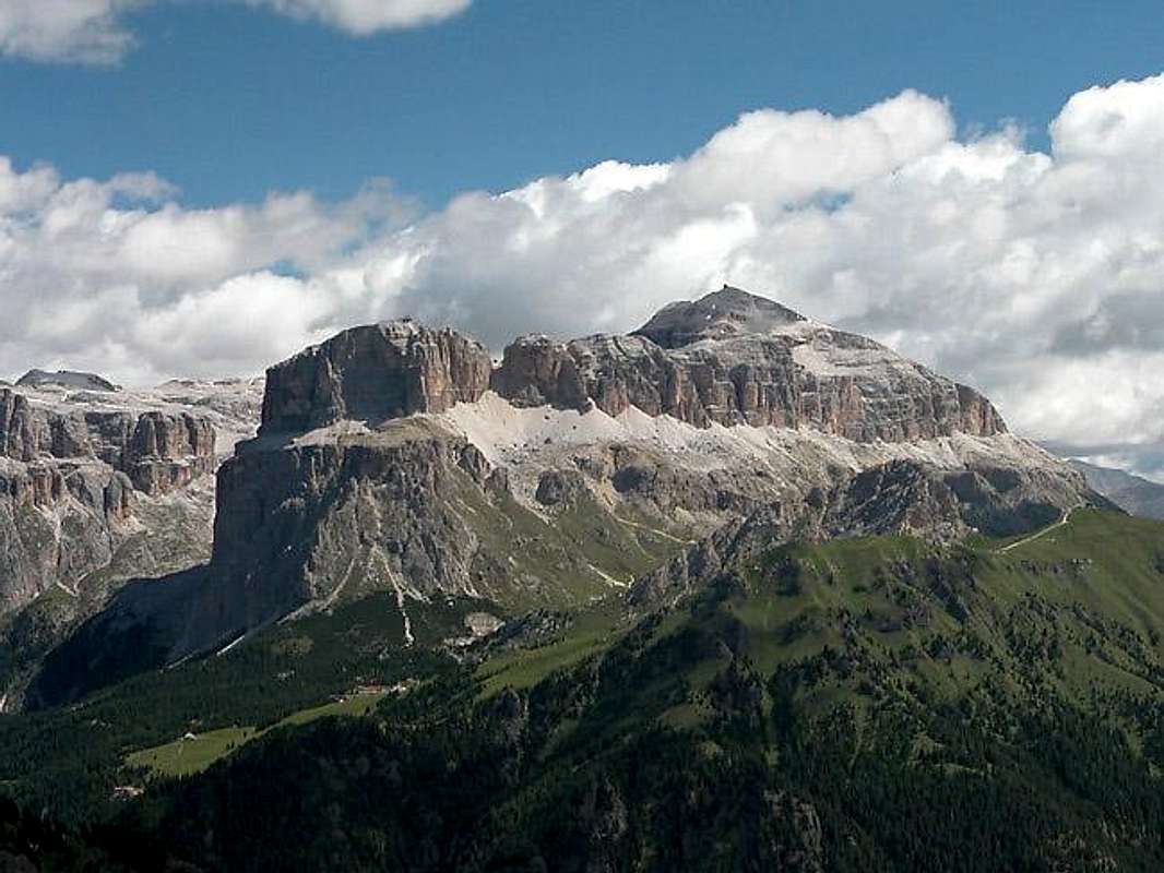 |
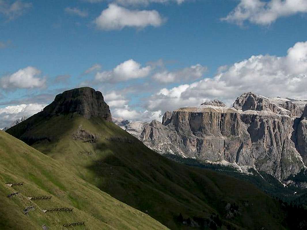
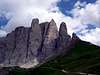
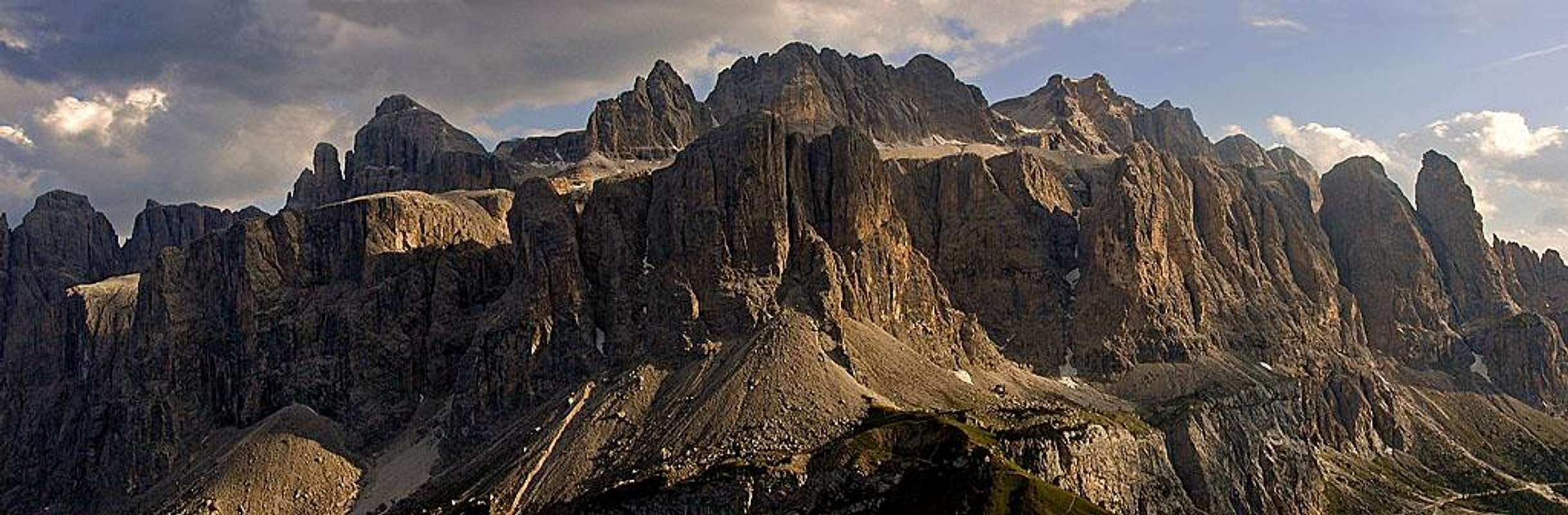
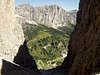
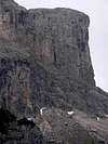
For hikers and climbers alike the Sella Group is one of the most interesting regions in the Dolomites. It is one of the most visited and best known areas of the whole Alps – access is very easy and there are a lot of hikes and climbs of differing difficulty to be chosen from. Moreover the Sella Group is located rather centrally in the Dolomites with perfect views towards all the surrounding mountain groups and ranges. It “boasts” the easiest 3000er of the Dolomites, Piz Boè, which can be climbed in less than two hours from the cable car station on neighbouring Sass Pordoi. On the more challenging side there are a lot of beautiful climbing summits, like the Sella Towers, Sass Pordoi or Boèseekofel (Piz da Lec de Boè). The Sella group is not as demanding as other Dolomite Groups; there are some very easy reachable places (Sella Türme, Piz Ciavazes, Sass Pordoi). As a result those summits are often very crowded.

When seen from afar (especially from the west) the Sella Group appears to be a giant inaccessible fortress. Vertical walls abound all around and a t fist glimpse there doesn’s seem to be an easy access. The group is shaped roughly rectangular with the short sides to the north and south. The vertical walls are broken into two storeys, a wide lower one with a narrower upper one placed on top. This results in a giant ledge running all around the huge group, the famous Sella Ringband, as it is called in German. Each outside climbing route first tries to attain this ledge before reaching for the upper faces. The top of the Sella Group is a huge structured summit plateau, a barren moonscape, which at close inspection reveals a large variety of hidden plant life among its cracks.
There are a couple of “weak spots” in this fortress however. From the north-east and south-west two deep cut valleys reach into the range, almost touching at its center. Val Lasties, a broad valley with massive walls on either side, heads up from the south-west into the centre of the group. From the north-east Val di Mesdi, the archetype of a narrow Dolomite valley, heads down to meet it. In addition to these valley you will find additional short and steep access gorges, the most famous of which is Val Setus, also coming up from the northern side, from Passo Gardena / Grödner Joch.
At the sides of the Sella rectangle there are four famous passes (especially among bikers and fans who follow the Giro d’Italia): Sella Joch/Passo Sella (W), Pordoijoch/Passo Pordoi (S), Passo di Campolongo (E) and Grödnerjoch/Passo Gardena (N). For skiers and bikers (and motorcyclists) the tour around the Sella is well known as "Sella ronda"/"Sellarunde". The sides of the rectangle are escorted by the roads to those passes, so approach to the group is always very easy.
Overall there are about 75 primary summits and lots of secondary pinnacles, towers etc. not counted as "real" mountains by themselves. The Sella group can be divided into several subgroups (see the overview map above for details).
 |
 |
 |
 |
 |
1 - Sella Towers and Piz Ciavazes
To the south-west of the Sella Group you will find this little subgroup (indicated in yellow on the interactive map above). It consists of Piz Ciavazes and the five Sella Towers which are located at the southern tip of the group. All summits are well known climbing destinations, which can easily be reached from Sella Pass by a short half hour hike.
Consequently the area is very crowded, especially the routes on the first and second Sella towers. Piz Ciavazes offers such a variety of routes that the crowds disperse. All routes are located on the southern and western faces and make for good afternoon climbing.
- First Sella Tower, 2533 m, an easy regular route, famous climbs, very crowded
- Second Sella Tower, 2598 m, few easy routes, many famous and good climbs, very crowded
- Third Sella Tower, 2696 m, no easy route, good and famous climbs, crowded
- Fourth Sella Tower, 2605 m, seldom visited, more demanding as the other Sella Towers
- Fifth Sella Tower, 2500 m, seldom climbed
- Piz Ciavazes, 2828 m, very often visited with many famous and frequently done routes
 |
 |
 |
 |
 |
2 - Pordoi and Val Lasties
Val Lasties is the broad valley which cuts into the Sella Group from its south-western end. It is lined by very impressive vertical faces the most important of which is Sass Pordoi, the southernmost rampart of the Sella Fortress. Sass Pordoi can be reached by cable-car and is definitely one of the most crowded mountaintops in the whole Alps. From there the whole Sella Group can be explored within a day.
Quite to the contrary the other summits surrounding Val Lasties are rather solitary while the valley itself is one of the main (hiking) traffic routes into the group. Especially the western summits like Piz Selva are visited by two dozen people per day only, most of whom use the difficult Pößnecker Ferrata to reach it.
The trailheads for this subgroup are either Pordoijoch/Passo Pordoi (cable car, S-face routes) or Pian Schiavaneis (for the huge NW-face of Sass Pordoi). Pian Schiavaneis is also trailhead for all summits of Val Lasties.
- Piz Selva, 2941 m, the Via Ferrata "Pößenecker-Steig" (= regular route) leads up to the summit, therefore often visited
- Piz Lasties, 2875 m, seldom climbed but some good routes, regular route and descent is the N-ridge (some easy scrambling)
- Torre del Siella, 2831 m, very rarelyclimbed, some good routes, regular route is the N-flank (rated 3)
- Piz del Siella, 2795 m, very easy approach from north (just hike up, no trail but easy)
- Piz del Roces, 2779 m
- Torre di Roces, 2754 m, rarely visitied, some good routes
- Col Alton, 2882 m, a harmless hillock close to Col Turond, easy hike from Rif. Boè.
- Sass Pordoi, 2950 m, the free hanging cable car from Prodoijoch/Passo Pordoi reaches the summit. It's a very popular mountain, one of the most crowded areas of the whole alps. Nevertheless in a very beautiful setting. In the S-face you can find several often climbed mid-grade routes (e.g. Mariakante), in the huge NW-face there are some very long, classic and great routes (Via Fedele, Via Niagara, ...).
- Sass de Moles (Piccolo Pordoi), 2692 m, the SW continuation of Sass Pordoi, easy approch without climbing from the east, big W-face, but seldom visited.
- Torre Schiavaneis, 2610 m, highest of the Torri del Pordoi, slender pinnacle close to the Sass de Moles
- Torre Micheluzzi, 2608 m, second highest of the Torri del Pordoi
- Torre Fosca, 2576 m, the most remarkable of the Torri del Pordoi
 |
 |
 |
 |
 |
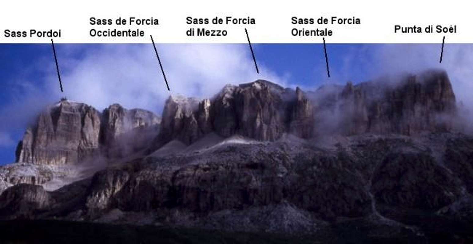
3 - Piz Boè, Valbon
Piz Boè is the highest summit of the Sella Group and "the easiest 3000er in the Dolomites". For climbers this mountain doesn't offer interesting routes but for hikers it offers several (very crowded) routes. There also is a difficult ferrata, Via Ferrata C. Piazzetta, on the south-east face of the mountain. The mountains of the Valbon Area (Sass dals Nü, Sass dals Diesc, Boèseekofel) are somewhat unknown but are offering a very interesting area for both climbers, hikers and ferratisti.
Trailheads for Piz Boè and its western satellites (Sass de Forcia, Punta di Soél etc.) are Pordoijoch / Passo Pordoi or Passo di Campolongo. Trailheads for the Valbon Area are Corvara (cable car to Crep de Munt) or Passo di Campolongo.

- Piz Boè, 3152 m, highest summit of the Sella group, verycrowded, the summit offers great views to all the mountains of the western Dolomites.
- Sass de Forcia Occidentale, 2923 m, east of Forcella Pordoi, easy access from the Vallon-hut, a good route at the SW-face (Via Masè Dari, 5)
- Sass de Forcia di Mezzo, 2917 m, easy approach from the Forcella Pordoi with a recommended route at the S-face (Via Piaz/Del Torso, 5+)
- Sass de Forcia Orinetale, 2880 m, rarely visited
- Punta di Soél/Punta di Joel, 2945 m, some hard, very seldom done S-face routes
- Punta di Larsei, 2952 m, easy approach from Rif. Valbon (marked trail Nr. 638), at the S-face some climbing routes
- Punta delle Fontane, 2915 m, below Rif. Valbon
- Pala delle Guide, 2781 m, easy approach from Rif. Valbon ("Lichtenfelser Weg, marked trail number 672), some good, recommended climbs on the N and E faces, very close to the hut.
- Sass del Rifugio, 2722 m, several nice routes
- Col de Stagn, 2517 m, hillhock with Rif. Valbon at the top, two E-face routes (Schwarze Magie, 8- and Reservestreifen, 6+)
- Bec de Roces, 2187 m
- Pizza Longata, 2961 m, easy approach from Rif. Valbon ("Lichtenfelser Weg, marked trail number 672)
- Sass dals Nü/Neuner/Sasso delle Nove, 2904 m, one of the three main summits of the Valbon hollow with some very good routes, enjoyable E-face, big W-face, no easy access (at least climbing of UIAA 3)
- Sass dals Diesc/Zehner/Sasso delle Dieci, 2916 m, the second of the Valbon-mountains, steep faces on all sides, a lot of good, recommended but seldom done routes. No easy route.
- Boèseekofel/Piz da Lec de Boè, 2911 m, a great place for mountaineering. The summit offers a Via Ferrata, an easy regular route and many good but although seldom done climbs. Huge, lonesome W-face.
- Torre Fulvio, 2700 m, big tower E of Boèseekofel
- Bastione dei Camosci, 2554 m, harmless hillhock close to the Crep de Munt, some bolted routes, a nice place for beginners
- Pizkofel/Torre del Piz da Lec, 2829 m, N of Boèseekofel, easy approach from SE
- Campanili de Mesdi, 2276m, 2293 m, 2408 m, secluded towers W of Pizkofel, very rarely visited
- Runggaldierturm, 2362 m, very seldom visited mountain
 |
 |
 |
 |
 |
4 - Pisciadu
This area is located to the north of the Sella Group and west of the deep cut of Val di Mesdi. It is characterised by its many famous climbs, the Via Ferrata Brigata Tridentina (Pisciadu Klettersteig) and its deep and narrow valleys. The main summit is Cima Pisciadu, which can be reached easily from the Sella Plateau but the main attractions are the spires and towers along Val di Mesdi.
The subgroup can easily be accessed from either Passo Gardena / Grödner Joch or the village of Colfosco / Kolfuschg (located at the mouth of Val di Mesdi) With a 90 minute hike you also can reach the area from the cable car station at Sass Pordoi.
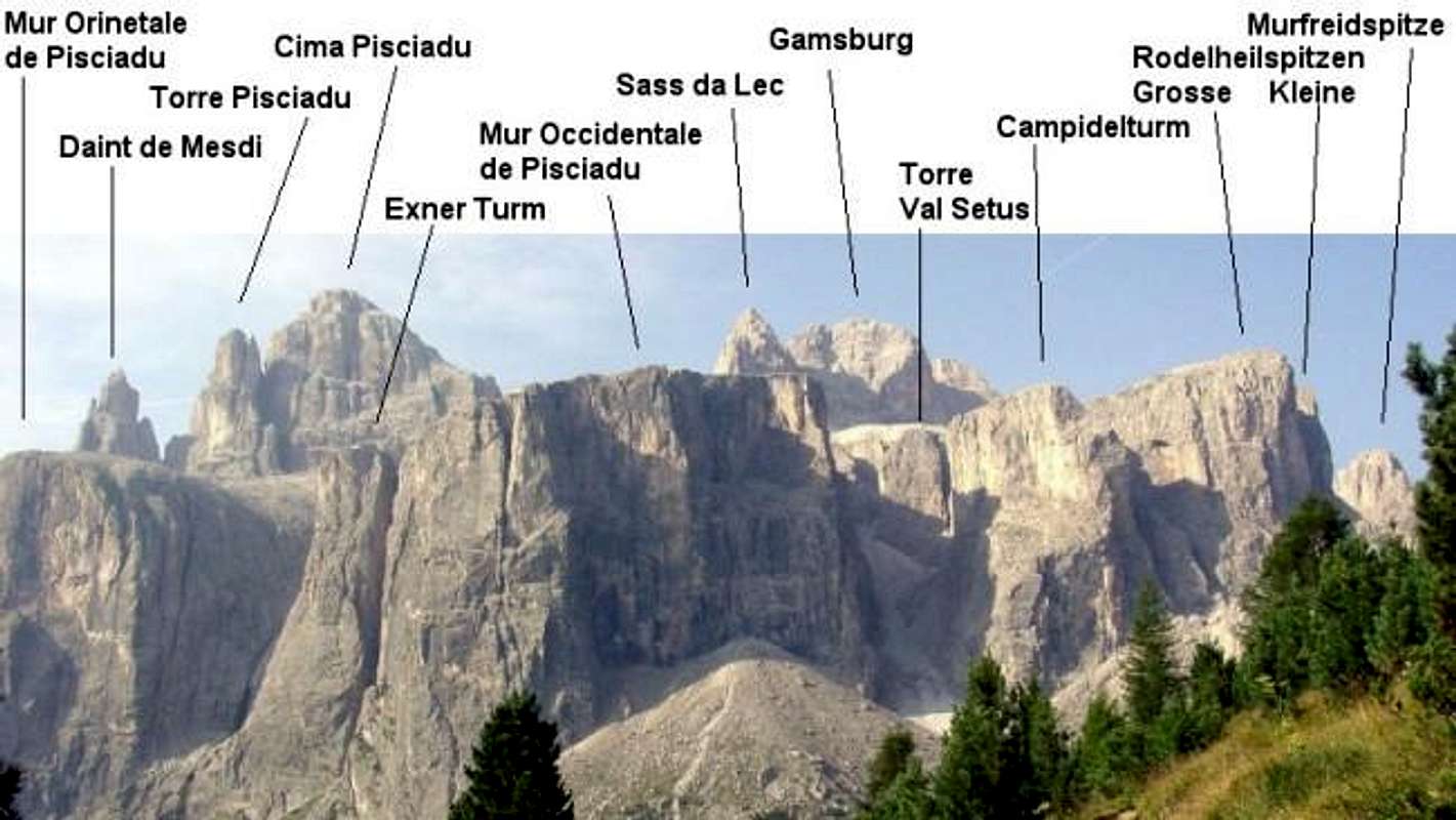
- Zwischenkofel/L'Antersass, 2907 m, between Val Lasties and Val de Mesdi, easy approach from trail 647. Great views because this is the centre of the Sella Group.
- Bergerturm, 2861 m, slim tower close to the Rif. Boè, an amusing regular route (UIAA 3)
- Sass de Mesdi, 2980 m, easy approach from W along trail 647, big, lonesome face above Val di Mesdi
- Bec de Mesdi, 2967 m, a big, steep S-face with famous and good routes. Actually those are seldom visited because of the long, exhausting approach.
- Daint de Mesdi, 2881 m, impressive, steep pinnacle, the regular route was listed in the famous "Im leichten Fels" by Walter Pause, beside this famous route other good routes on the S-face with long approaches.
- Pisciaduspitze/Cima del Pissadu, 2985 m, famous, easy accesable summit south of the Rif. Pisciadu. Often visisted. On the N- and W-faces some popular routes.
- Pisciaduturm/Torre del Pissadu, 2882 m, No easy route, an impressive mountain, some good climbs
- Sass Masores Orientale/Mur Pissadu Orinetale, 2530 m, easy approach from SW (from trail 664), steep E- and N-faces with solid rock
- Exnerturm/Torre Exner, 2494 m, impressive tower with the "Via Ferrata Brigata tridentina"
- Sass de Masores Occidentale/Mur Pissadu Occidentale, 2560 m, no "real" summit but huge faces with easy approach and easy descent. Many excellent routes.
 |
 |
 |
 |
 |
5 - Murfreid and Mesules
This subgroup consists of the western part of the Sella Fortress. As seen from the top rarely a summit stands out above the Altipiano delle Meisules but seen from the outside this is the part where the character of the Sella Group is best seen. There are two large steps both consisting of vertical walls, several 100m high. There are several very steep valleys, the broadest of which, Val Setus, is the main access route from this side of the group. The west faces of the summits almost all offer a multitude of high quality classic routes and the famous Ferrata delle Meisules / Pößnecker Klettersteig heads up to the southernmost summit, Piz Selva.
Trailhead for the northern part (Torre Val Setus to Murfreidspitze) is Grödnerjoch/Passo Gardena (or somewhere on theroad to the pass). Access point to the Murfreid Area is Plan de Gralba at the road to Sella Joch/Passo Sella. For the southern part (Piz Selva, Piz Miara etc.) best approach is from the road to the Sella Joch/Passo Sella. Also the long traverse of the Altipiano from the Sass Pordoi cable car can be recommended. You'll have to hike once around the whole group however.
- Sass dla Luesa, 2603 m, tower at the end of Val Setus with few but interesting routes, rarely climbed, no easy route
- Campanile delle Luesa, 2500 m, secondary summit close to the Rodelheilspitzen
- Campidellturm/Torre Campidel, 2529 m, beautiful tower, seldom visited but some nice routes (rated 4 or higher)
- Grosse Rodelheilspitze/Sass da la Luesa, 2615 m, close to Grödner Joch/Passo Gardena, steep faces with easy and short approach from Grödner Joch/Passo Gardena, very easy approach from S (just a harmless hike).
- Kleine Rodelheilspitze, 2603 m, similar to Grosse Rodelheilspitze/Sass da la Luesa, easy approach, big N-face with good routes
- Sass Val Culea, 2650 m
- Torrione Vitty, 2640 m, big and beautiful faces with good routes, rarely visited
- Torrione Holzer, 2650 m, hidden summit, rarely visited
- Murfreidspitze/Piz Ciampani de Murfreid, 2631 m, big, impressive tower with some good routes
- Torre dell'Independenza, 2663 m
- Masores de Murfreid, 2700 m
- Kleiner Murfreidturm/Pitl Ciampani de Murfreid, 2713 m, an impressive tower, easy regular route (but beware of rock fall), some good climbs at the S-face
- Grosser Murfreidturm/Gran Ciampanile de Murfreid, 2724 m, the higher of the Murfreid towers, some mid-grade routes
- Östlicher Mesulesturm/Torre Orientale delle Mésules, 2330 m, steep tower with very good rock quality, many very demanding trad-routes, very recommendable, but bring a full rack
- Westlicher Mesulesturm/Torre Occidentale delle Mésules, 2336 m, also steep faces with good rock quality, also some good routes
- Mésules da la Bièsces, 2457 m, steep, impressive faces above the road to the Sella Joch/Passo Sella. Easy approach, but very demanding routes. Some of the most difficult routes (up to UIAA 9/ US 5.13a) of the whole Sella Group can be found at Mésules da la Bièsces.
- Torre dei Quattro, 2888 m, big tower NE of Sass da Lec
- Sass da Lec, 2936 m
- Gamsburg/Sass dai Ciamorces, 2929 m
- Le Mesules/Les Meisules, 2999 m
- Piz Rotic, 2974 m
- Piz Beguz, 2972 m
- Piz Miara, 2964 m, often visited by hikers, some good but seldom done climbs up the faces
- Piz Gralba, 2972 m, rarely visited
- Fiechtlturm/Torre Fiechtl, 2540 m
- Piz Revis, 2940 m
 |
 |
 |
 |
 |
Climbing Spots
Frea
An area close to the route Wolkenstein - Grödnerjoch/Passo Gardena. Even in summer good conditions (not to hot). many, mostly very difficult routes, fully bolted. There are different sectors:
- Sonnentau:10 routes from 6b to 7c
- Himmelsleiter: 10 routes from 6b to 7b+
- Rechter Pfeiler: 8 routes from 6a to 7b
- Felsnelke: 4 routes (6b+,6b+, 6a, 6c)
- Herbstzeitlose: 8 routes from 6a to 7b
- Bittersüß: 5 routes (7a, 6c, 6b, 6b+, 6b+)
- Fingerkraut: 9 routes from 5+ to 7a+
Frea alpin
Steep faces below the Murfreidspitze, 5 multi pitch routes of UIAA grade 7
Snoopy-Platten
12 base climbs below the Mésules da las Bièsces from 6a to 7b
Traumpfeiler
Superb sport climbing area with great but demanding routes, fully bolted. There are different sectors:
- Traumpfeiler: 17 routes from 6c to 8a+, most routes have 1 to 3 pitches some even 6 pitches
- Woodstockplatten: one pitch routes from 6a+ to 7a
- Wasserfallplatten: one pitch routes from 6a to 8a+
Piz Ciavazes Baseclimbs
At the base of the Piz Ciavazes S-face there are different bolted, difficult routes at different sectors:
- Roberta, 7 multi pitch routes from 6b to 7b
- Pilastro Giallo, 11 routes from 4 to 7c+
- Avancorpo, 7 mid grade routes (4 up to 6a)
- Del Buco, 6 routes from 6a to 6c
- Di Destra, 7 routes from 5+ to 6b, mainly 5+/6a
Cogui
Great and famous crag at the base of the Piz Ciavazes, fully bolted routes, some artificial holds. Mainly very difficult, overhanging routes, climbable all around the year. About 50 routes from 5b up to 8c (!), mailny 6c and more. The easier routes ar not as good as the more difficult ones. A good place to watch very good climbers.
Palestra dei Bambini
A big bolder at the forest close to Pian Schiavaneis, nice and easy (4, 4+, 5, 5+, 6a, 4), fully bolted routes, good with children and for beginners
Steinerne Stadt/Città dei Sassi
Bolted routes in a beautiful setting close to Sella-Joch/Passo Sella. Big boulders which are somewhat tricky to find if you go there for the first time. Routes from 5 to 7c+ (5.9 to 5.13b)
Getting There
There are different villages all around the group, all offer hotel rooms and apartments: St. Ulrich / Ortisei, St. Christina and Wolkenstein / Selva di Gardena in Grödnertal / Val Gardena, Canazei and Campitello in Val di Fassa, Arabba north of Passo di Campolongo and Corvara and Colfuschg / Colfosco in upper Gadertal / Alta Badia.
Approach from S
From the south (Lago di Garda, Trento, ...) take the motorway A22. Leave this at Egna Ora and follow the highway 48 through Val di Fassa to Campitello or Canazei.
Approach from N
From north (Germany, Austria, ...) the usual way to reach the area is motorway A22 from Brennerpaß. Leave the motorway at Chiusa/Val Gardena and follow the road through Grödnertal/Val Gardena to St. Christina and Wolkenstein / Selva. Alternativly one may turn E at Brixen already and follow Pustertal / Val Pusteria up to St. Lorenzen. There Gadertal / Alta Badia turns off south south and leads you to Corvara and Kofuschg / Colfosco.
Approach from W
From the West (Switzerland, Bodensee, ... ) take the road to the Reschenpass / Passo Resia and travel SS38 through the Vinschgau Valley to Meran / Merano. From there a motorway brings you south to Bozen / Bolzano. Here turn off onto SS241 east across Karerpass / Passo di Costalunga into Val di Fassa. At Vigo di Fassa take SS48 north to Canazei. Alternatively take the Brenner motorway north from Bozen / Bolzano until you reach Klausen / Chiusa. Here turn off into Grödnertal / Val Gardena.
Approach from E
From the east (Cortina d'Ampezzo, Sexten Dolomites, ... ) follow SS48 via Passo di Falzarego to Arabba. From Belluno (coming from Venezia or Friuli) you can reach the Pordoi pass using the Canale d'Agordo Valley until you reach Alleghe. A bit further north the road from Falzarego joins and leads you to Passo Pordoi.
Trailheads:
Sella Joch/Passo Sella: From Grödnertal/Val Gardena (N) or Val di Fassa (S) follow the roads to the pass.
Pordoijoch/Passo Pordoi: From Val di Fassa (W) or Arabba (E) follow the roads to the pass.
Grödnerjoch/Passo Gardena: From Grödnertal/Val Gardena (W) or Gadertal/Corvara (E) follow the roads to the pass.
Passo di Campolongo: From Gadertal/Corvara (N) or Arabba (S) follow the roads to the pass.
Pian Schiavaneis: at the southern road to Sella Joch/Passo Sella, see above
Plan de Gralba: at the northern road to Sella Joch/Passo Sella, see above
 |
 |
 |
 |
 |
Red Tape
No red tape but take care to be early, especially for the Vie Ferrate or the ascents to Piz Boè and Cima Pisciadu. They can be terribly crowded.
When To Climb
Most common is summer, but some of the S-face routes may be possible all over the year. In winter heavy ski tourism of all kinds.
 |
 |
Huts
- Sella-Joch/Passo Sella:
All of the following huts are very easy accesable from Sella Joch/Passo Sella.
- Sellajochhaus, a mountain hotel with a long tradition close to the cable car to Langkofelscharte. Good trailhead for all routes of the western part of the Sella Group.
- Albergo Alpino Maria Flora, directly at Sella-Joch/Passo Sella, crowded, crowded, crowded ...
- Rifugio Valentini, a famous climbers hut, good trailhead for the western part of the Sella Group close to Sella-Joch/Passo Sella
- Rifugio Salei, close to Rifugio Valentini
- Pordoi/Val Lasties
- Col di Lana, hotel at Pordoijoch/Passo Pordoi, starting point for Sass Pordoi and the SE part of the Sella group
- Rifugio Forcella Pordoi, at Pordoischarte/Forcella Pordoi
- Albergo Maria, at the top of the cable car to Sass Pordoi
- Rif. Tita Piaz, close to the mid station of the cable car Canazei - Col di Ross
- Pian Schiavaneis, at the road Canazei - Sella Joch/Passo Sella
- Rifugio Monti Pallidi, close to Pian Schiavaneis
- Piz Boè and Valbon
- Capanna Fassa, 3152 m, on the top of the Piz Boè
- Albergo Cherz, at Passo Campolongo
- Albergo Boè, at Passo Campolongo
- Hotel Laguscei, at Passo Campolongo
- Rifugio Boè/Boèhütte, 2871 m, CAI-SAT
- 2-3 hours from Pordoijoch/Passo Pordoi (without cable car, with cable car only 1/2 h from the summit of Sass Pordoi)
- 3-4 hours from Kolfugsch / Colfosco along Val de Mesdi
- 3 hours from Pian Schiavaneis up Val Lasties
- 2-3 hours from Rifugio Pisciadu
- Valbonhütte/Rifugio Kostner, 2536 m, CAI Bozen, a small hut at Col de Stagn
- 2 hours from Passo Campolongo without cable car to Crep de Munt
- 3/4 hour from Crep de Munt
- 1/4 hour from top of the Valbon chair lift
- Pisciadu
- Rifugio Pisciadu/Pisciaduhütte, 2587m, CAI Bologna, different approches:
- 1,5 hours from Grödnerjoch/Passo Gardena
- 3 hours from Kolfugsch / Colfosco up Val de Mesdi
- 2-3 hours from N using Via Ferrata "Tridentina"
- 1-2 hours from Rif. Boè
- Rifugio Pisciadu/Pisciaduhütte, 2587m, CAI Bologna, different approches:
- Murfreid and Mesules
- Café Gerard, at the road between Plan de Gralba and Grödnerjoch/Passo Gardena
- Haus Frara, at Grödnerjoch/Passo Gardena
- Haus Cir, at Grödnerjoch/Passo Gardena
 |
 |
 |
Camping
All around the group you can find a number of campgrounds:
Val di Fassa:
- Marmolada
via Pareda
Canazei
Tel.: +39 0462.601660
Fax: +39 0462.601722
- Catinaccio
via Avisio 15
Pozza di Fassa
Tel.: +39 0462.763305
Fax: +39 0462.763501
- Soal
via Dolomiti 32
Pera di Fassa
Tel.: +39 0462.764519
Fax: +39 0462.764609
- Vidor
Località Vidor
Pozza di Fassa
Tel.: +39 0462.763247
Fax: +39 0462.764780
Gadertal / Alta Badia
- Camping Colfosco Corvara
Str. Sorega, 15
39033 Colfosco (BZ)
Tel. +39 0471 836 515
Fax +39 0471 830 801
info@campingcolfosco.org
Accommodation
The best information on boarding houses and hotels can be found on www.dolomiti.it. The site is not complete – you might find more information on local tourist web sites, but it already offers an impressive list. The following listing gives you an overview for the larger towns and villages surrounding the Marmolada Group.
Val di Fassa
Grödner Tal / Val Gardena
- www.valgardena.it
www.groeden.info - St. Ulrich / Ortisei
- St. Christina / Santa Christina
- Wolkenstein / Selva di Val Gardena
Gadertal / Alta Badia
Arabba / Livinallongo
Weather Conditions
Weather conditions Dolomites:www.dolomitimeteo.com
Weather and avalanche conditions in Trentino: www.meteotrentino.it
Weather conditions South Tyrol / Alto Adige:www.meteoalpin.com
In addition most of the links posted in the "accommodation section also have weather info and/or webcams.
Maps and Books
Books:
There is one very recommendable book, Sella - Langkofel Extrem, which the original submitter kletterwebbi used to help put up this page. It gives an overview over hundreds of climbing routes in the area. Two thirds of the book deal with the Sella Group.
- Climbing
- Sella - Langkofel Extrem
Richard Goedecke
Alpenvereinsführer
Rother Verlag
ISBN: 3-7633-1315-X - Val di Fassa - Guida alle arrampicate sportive
Renato Bernard/Gabriele Bonnano
Dora' Publisher, Bolzano - Sella e Sassolungo
Luca Visentini
Ed. Athesia, Bolzano/Bozen. (both in Italian and German languages) - Classic Dolomite Climbs: 102 High Quality Rock-Climbs Between the Uiaa Grades III and VII (also available on CD)
Anette Kohler, Norbert Memmel
Mountaineers Books
ISBN: 0 8988 6693 6
- Sella - Langkofel Extrem
- Vie Ferrate
- Klettersteige Dolomiten
H. Höfler, P. Werner
Rother Verlag
ISBN: 3 7633 3096 8 - Hülslers Klettersteigführer
E.E.Hülsler
Bruckmann Verlag
ISBN: 3 7654 4161 9
- Klettersteige Dolomiten
- Hiking and Trecking
- Höhenwege in den Dolomiten
H. Dumler
Bruckmann Verlag
ISBN: 3 7654 3860 X - Dolomiten
P. Fleischmann
Kompass Verlag
ISBN: 3 8705 1409 4 - Dolomiten 3
F. Hauleitner
Rother Verlag
ISBN: 3-7633-4060-2 - Dolomiten 4
F. Hauleitner
Rother Verlag
ISBN: 3-7633-4061-0
Maps:
I have been using the maps by Kompass Verlag. There are two which differ in scale:- Val di Fassa, Marmolada, Gruppo di Sella
Kompass Map WK 686
ISBN: 3 8549 1768 6
Scale: 1:25000 - Sellagruppe / Gruppo di Sella
Kompass Map WK 59
ISBN: 3 8549 1066 5
Scale: 1:50000 - Val Gardena & Alpe di Siusi
Tabacco Map 05
![]()
![]()
![]()
![]()
![]()
- Höhenwege in den Dolomiten


