
-
 73606 Hits
-
 95.51% Score
-
 53 Votes
|
|
Area/Range |
|---|---|
|
|
46.25000°N / 11.85000°E |
|
|
10472 ft / 3192 m |
|
|
Overview
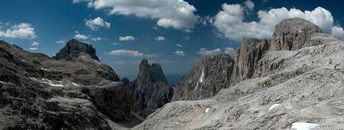
 Panorama of the Pale di San Martino Group from the northwest.
The Pale di San Martino Group is the southernmost of the big Dolomite Groups. It is surrounded by deep valleys on all sides which makes the access to this group rather easy. The Group is located on the borders of the Italian provinces of Trento and Belluno within the "Parco Naturale Paneveggio - Pale di San Martino". With its five subgroups the Pale di San Martino is one of the largest groups in the Dolomites. It therefore boasts some of the most interesting hiking and climbing routes of the whole region . To me Pale di San Martino are two views of pairs of mountains:
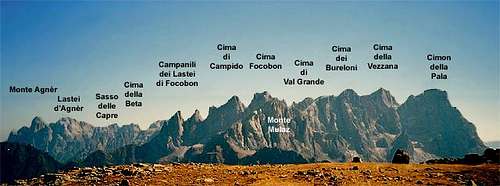
- the highest summits Cimon della Pala and Cima della Vallazza as seen from Passo di Rolle, a picture that has been published on thousands of picture postcards, guide books and Dolomite picture books
- the pair of Sass Maor and Cima della Madonna in the south of the group locked in an eternal embrace. Look at a picture of the two taken from Rifugio Pradidali and you'll se what I mean.
The group is charachteristic of many of the Dolomite groups. Like the Sella- or Puez-Groups it contains a barren high plateau (at approx 2600m), the Altopiano delle Pale di San Martino. Again, like in most other Dolomite groups the highest summts are at the edges of this plain. From a geological point of view this structure can be explained with the fact that the Pale di San Martino Group used to be an atoll in the Thetis-Sea some 230 - 50 Million years ago. The Altopiano during that time was the inner lagoon of that atoll. Another - even nicer - example for this effect is the Langkofel / Sassolungo - Group. Just have a look at the map and with a little fantasy you'll see the atoll (minus the lagune).
The Pale di San Martino Group on SP
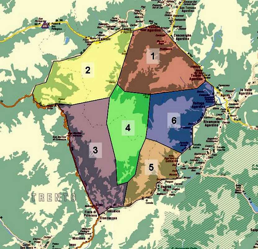  |
The Pale di San Martino Group generally is divided into six subgroups. The further sections will deal with these subgroups in more detail. There are
- Pale di San Lucano
- Northern Chain
- San Martino Chain
- Central Chain
- Southeastern Chain
- Monte Agner Group
1 - Pale di San Lucano
 |
The subgroup of Pale di San Lucano is located to the northeast of the Pale di San Martino Group between Val Canal to the north, Valle di San Lucano to the south, Valle di Garès to the west and Val di Cordevole to the east. The subgroup is formed by a single main ridgeline (NNE to SSW) with two major summits on a ridge leading to the southeast. In addition, south of val del Torcol there is another ridgeline with Monte San Lucano which gave the name to the whole subgroup. The Pale di San Lucano is the lowest of the subgroups. Main ridge (listed from north):
- Cima Pape o Sanson (2503m)
- Lastei di Pape (2484m)
- Cime dei Vanediei (2380m and 2315m)
- Monte Caoz (2293m)
![]()
- Cima Caoz (2050m)
![]()
- Monte Palalada (1973m)
![]()


Side ridge (running to SE from Lastei di Pape):
- Monte Prademur (2361m)
- Monte Piaon de Prademur (2184m)
San Lucano ridge (south of Val del Torcol:
- Prima Pala di San Lucano (2221m)
- Seconda Pala di San Lucano (2340m)
- Terza Pala di San Lucano (2355)
- Monte San Lucano (2409m)
- Cima di Ambrusogn (2266m)
2 - The Northern Chain
 |
To the west of Pale di San Lucano beyond Valle di Garès the northern chain runs from NNE to SSW forming a long ridgeline (approx. 10km) that starts at Monte Palmina in the north and runs through Cimon della Pala in the South. Two smaller ridgelines turn off to the northwest beyond Monte Mulaz and Cimon della Pala. To the north this subgroup is limited by Valle di Vallés, to the west by Val Venegia and to the south by Passo Travignolo east of Cimon della Pala.The eastern limits are Val di Garès and Val delle Comelle. This subgroup contains the highest summits of the whole Pale di San Martino Group. Main ridge (listed from north):
- Monte Palmina (2033m)
- Monte Tamer (2264m)
- Cima dei Palogin (2266m)
- Cimon della Stia (2391m)
![]()
- Punta dei Mar (2365m)
- Campanili dei Lastei di Focobon (2721m)
![]()
- Cima Zopel (2813m)
- Cima di Campido (3001m)
![]()
- Cima Focobon (3054m)
![]()
- Campanile del Focobon (2969m)
- Torre Quattro Dita (2932m)
![]()
- Campanile di Val Grande (2995m)
- Cima di Val Grande (3038m)
![]()
- Cima dei Bureloni (3130m)
![]()
- Campanile di Val Strut (3049m)
- Campanile Travignolo (2865m)
- Cima delle Comelle (2951m)
![]()
- Cima della Vezzana (3192m) Normal Route grade I, alltogether 750m
![]()
- Cimon della Pala (3184m) Normal Route grade III, secured with cables, 120m climb
![]()
- Dente del Cimone (2675m)
![]()


Northern side ridge (running to NW from Passo del Mulaz to Passo di Vallés):
- Monte Mulaz (2906m) West Face, Grey Pillar: grade VI, ten pitches over 350m
![]()
- Cima Venegiota (2401)
- Cima Caladora (2313m)
- Cima Vallés o Venegia (2305m)

Southern side ridge (running to NW from Cimon della Pala):
- Punta Rolle (2267m)
- Costazza (2275m)
- Castellaz (2333m)
![]()

3 - The San Martino Chain
South of Passo Travignolo the ridge turns to SSE. This new ridgeline composes the San Martino Chain, starting at the pass and ending at Lasta del Sol its southernmost outpost. To the west the subgroup is limited by Val Cismon, to the east by Val Pradidali. The southern end is located at the intersections of Val Cismon and Val Canali north of Fiera di Primiero. The subgroup is composed by some of the finest summits of the Pale di San Martino Group, among them Sass Maor and Cima della Madonna. San Martino Chain ridge (listed from north):
- Cima Nuvolo (3075m)
- Croda della Pala (2960m)
- Dente del Cimone (2675)
![]()
- Cima Corona (2768m)
![]()
- Cima della Rosetta (2743m) La Rosetta has its own page on SP. See here for more information.
![]()
- Torre Felicita (2244m)
- Croda di Roda (2694m)
- Campanili di Val Roda (2516m)
![]()
- Cima Val di Roda (2791)
![]()
- Campanile Pradidali (2733m)
![]()
- Cima di Ball (2802m)
![]()
- Cima di Val della Vecchia (2480m)
- Sass Maor (2814m) Normal Route grade III+, 400m climb
![]()
- Cima della Madonna (2752m) Reportedly the most beautiful climb in the Dolomites: The Veil's Edge - grade V+ / D+, 10 pitches over 400m
![]()
- Cima Stanga (2550m)
![]()
- Cimerlo (2505m)
![]()
- Lasta del Sol (2100m)


4 - The Central Chain
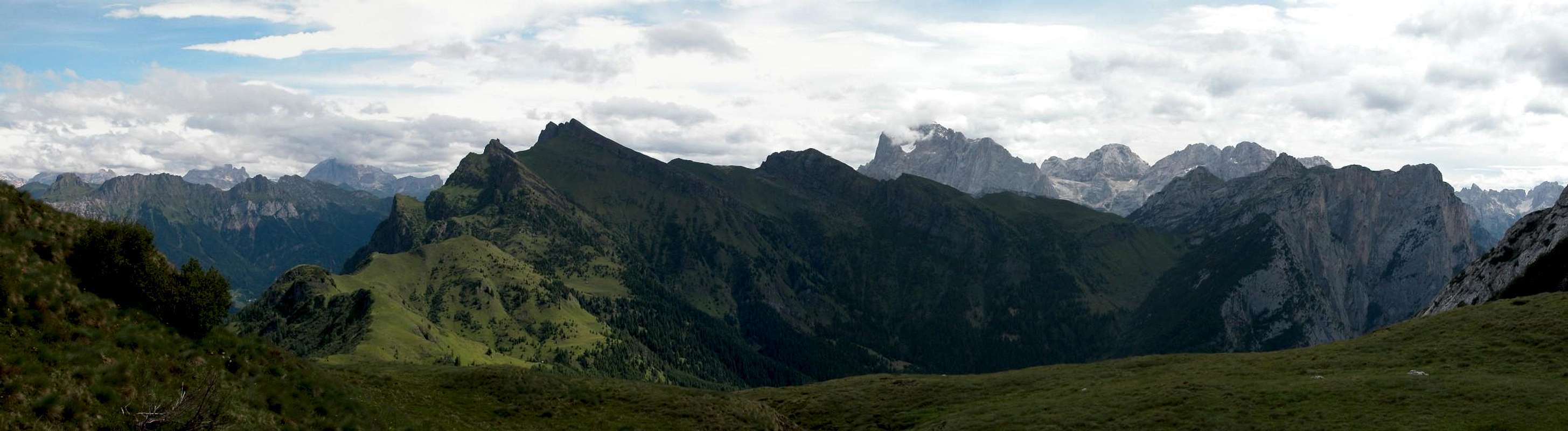
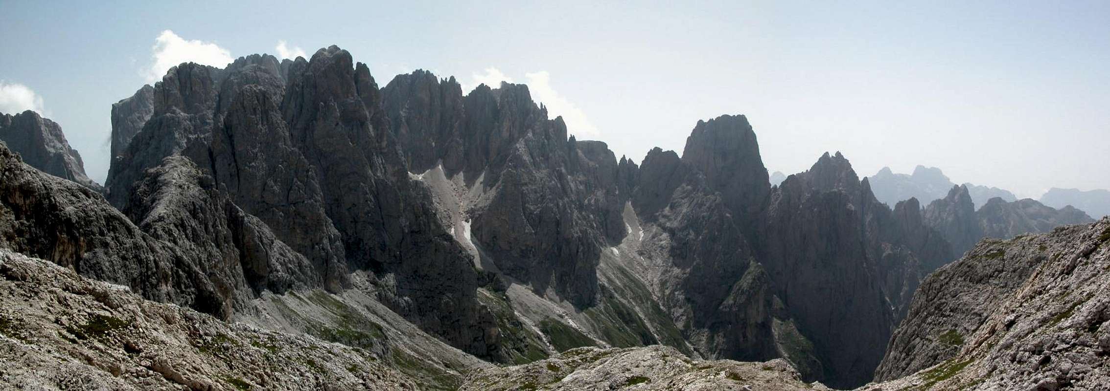
 Looking from Passo Pradidali Basso into Val Pradidali
The Central Chain is not so much of a single ridge - it is rather a wild conglomerate of summits rising out of the high plateau, the Altopiano delle Pale di San Martino. Most of the summits are located to the south and east of this plain. To the north some lesser ridges limit the Altopiano towards Val di San Lucano and Forcella Cesurette o Campigat which separate the Central Chain from the Pale di San Lucano Subgroup. Val Pradidali to the west and south, Valle d'Angheraz and Forcella dell'Orsa to east are the further limits. The following descriptions start at Pala di San Martino and follow a circle at the southern edge of the group. The solitary Cima Fradusta is located a little to the north and will be descibed separately together with some further peaks which seem to form a second ring. Central Chain (southern half circle):
- Cima di Roda (2694m)
![]()
- Cima delle Scarpe (2802m)
![]()
- Pala di San Martino (2996m) Great grade IV- Climb on the Big Pillar. 20 pitches on 600m with grades between II and IV-.
![]()
- Cima Immink (2855m)
![]()
- Cima Pradidali (2693m)
![]()
- Torre Pradidali (2774m)
- Cima Wilma (2777m) Normal Route grade III+, 260m climb Southwest Edge "Castiglioni/Detassis": grade V, 10 pitches over 300m
![]()
- Cima Canali (2900m) Buhl-Crack with 14 pitches up to grade VI+. Height 600m
![]()
- Pala Canali (2720m)
![]()
- Sasso delle Lede (2580m)
![]()
- Campanile d'Ostio (2405m)
- Cima di Sedole (2244m)
![]()
- Pala dei Colombi (2232m)
- Cima dei Lastei (2798m) Normal Route grade II on 100m, 1150m alltogether
![]()


Second "Ring":
- Cima della Fradusta (2939m)
![]()
- Campanile della Fradusta (2779m)
![]()
- Cima Manstorna (2816m)
![]()
- Pizzo del Miel (2784m)
![]()


5 - The Southeastern Chain
 |
The southeastern chain, running as a single ridge NNE to SSW, is separated from all other parts of the Pale di San Martino Group by Valle d'Angheraz and Val Canali. Only at Colle Canali, where the two valleys meet there is a connection to the group.The southeastern chain is much less frequented than the other parts of the group but still offers fine hikes, climbs, ferrate and traverses. If you shy away from crowded places this is the place to go. The mountains are listed from south to north culminating in the highest peak of this chain, Monte Agner. Southeastern Chain:
- Dalaibol (2006m)
- Tacca Bianca (2141m)
- Monte Feltraio (2295m)
- Le Rocchette (2260m and 2309m)
- Cima d'Oltro (2397m)
- Punta del Calderon (2288m)
- Torre Dresda (2319m)
- Sforcelloni (2450m)
- Pala della Madonna (2524m)
- Punta della Disperazione (2083m)
![Pale di San Martino Group photo_id=85502]()
- Sass D'Ortiga (2634m) Normal Route grade II+, 400m alltogether Southwest Face: grade VI / A0, 9 pitches over 250m Southwest Edge: grade VI-, 9 pitches over 300m
- Pala del Rifugio (2394m) Northwest Ridge: grade V, 16 pitches over 650m Northwest Face: Grade V+, 15 pitches over 600m
![Pale di San Martino Group photo_id=85354]()
- Cima Sta Anna (2461m)
- Sass da Camp (2733m)
- Cime Vani Alti (2690m)
- Torri Vani Alti (2445m)
- Croda Grande (2849m)
- Cime del Marmor (2698m)
- Cima del Coro (2670m)
![Pale di San Martino Group photo_id=85352]()
- Cima d'Alberghetto (2574m)
- Cima Orsa (2472m)


6 - Monte Agner Group
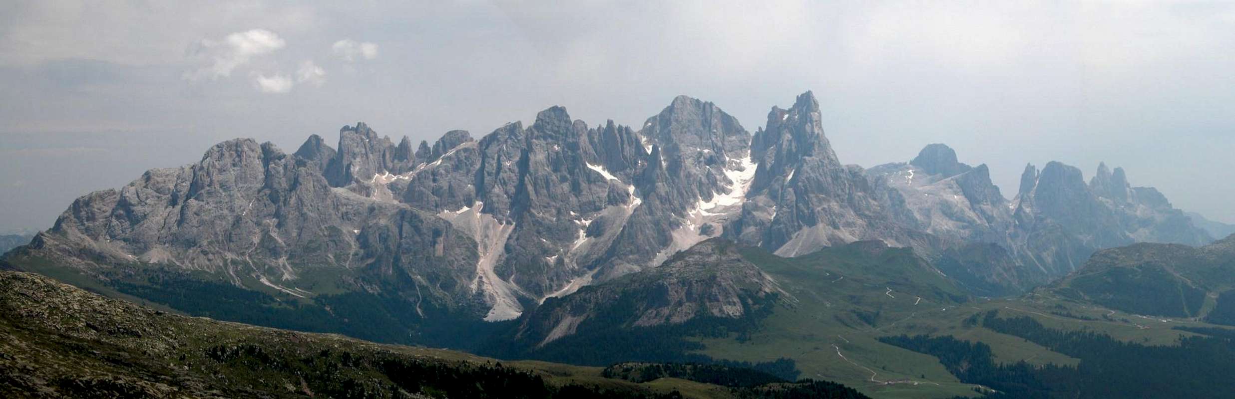
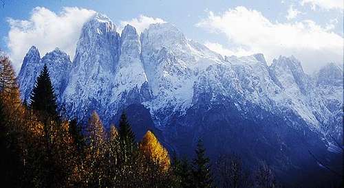 The Monte Agner Group seen from the meadows above Col di Pra
Agner and the surrounding peaks are sometimes treated as a separate subgroup with all summits north of Croda Grande belonging to the Agner Subgroup. In the list below these would be the mountains below Croda Grande.
- Cima de la Beta (2707m)
- Sass de le Snare (2708m)
- Sass delle Capre (2762)
- Lastei d'Agner (2844m)
- Torre Armena (2652m)
- Monte Agner (2872m) Normal Route grade II-, 1200m alltogether Via Gilberti (north face), 1600m (see this (german) trip report from 1952) Via Vinci (northwest wall), also 1600m Both routes are counted among the longest and highest in the whole Alps
![Pale di San Martino Group photo_id=95874]()
![Pale di San Martino Group photo_id=125414]()
![Pale di San Martino Group photo_id=125415]()
- Spiz d'Agner Sud (2617m)
- Spiz della Lastia (2295m)
- Dente di Satanasso (2040m)
- Cima Valtorta (1937m)
- Sass Pian (1862m)


Getting There
The following itineraries describe how to reach Fiera di Primiero (on the map it is a little northwest of Mezzano at the road intersection SS50-SS347).
- Motorway A13 (Bologna-Padova) exit Padova South or Padova West; SS47 della Valsugana (in the direction of Bassano/Trento) up to Cismon del Grappa; SS50bis (in the direction of Feltre/Belluno) up to Arten; SS50 to Fiera di Primiero
- Motorway A4 (Torino-Trieste) up to Vicenza and motorway A31(Vicenza-Valdastico) exit Dueville; SS47 della Valsugana (in the direction of Bassano/Trento) up to Cismon del Grappa; SS50bis (in the direction Feltre/Belluno) up to Arten; SS50 to Primiero
- Motorway A22 (Modena-Verona-Brennero) exit Trento center; SS47 della Valsugana (in the direction Bassano/Padova) up to Cismon del Grappa; SS50bis (in the direction of Feltre/Belluno) up to Arten; SS50 to Primiero
- Motorway A22 (Modena-Verona-Brennero) exit Egna-Ora (BZ); SS48 (in the direction of Val di Fiemme - Val di Fassa) up to Predazzo; SS50 to Passo Rolle, San Martino di Castrozza, and Primiero
The other towns in the area can be reached from Fiera di Primiero as follows:
- San Martino di Castrozza is located to the north of Fiera di Primiero (along SS50).
- Falcade in the north can be reached from Fiera di Primiero by going up SS50 north to Passo Rolle, then right on SP81 (not shown on the map).
- Agordo can be reached by driving SS347 northeast.
Red Tape - The Natural Park Paneveggio - Pale di San Martino
The Natural Park consists of the area of the Pale di San Martino Group as well as the forest of Paneveggio and the porphyritic chain of Lagorai. It contains an area of 125 sqare km which in 1987 has been divided in three different levels of protection: 33% of the area have been assigned complete protected areas, 60% are restriced areas while 7% are controlled area. For more information you can look at the Park's official website. There are no fees or limitations for hiking and climbing, however you might have to be prepared for small parking fees.
When To Climb
As with all Dolomite summits the best time is late May through early October but winter ascents and ski tour ascents are possible as well. Best time in my opinion is September or early October since apartments are easily to be had and weather often is finest (but cold!). One of the most popular ski tours in winter is the traverse of the Altopiano from Cima Rosetta to Passo di Canali with the following descent into Val Canali.
Mountain Huts and Refuges
The following Mountain Huts, Refuges can be found in the Pale di San Martino Group: Rifugios:
| Rifugio / Hut | Height | Open | Tel. |
| Baita La Ritonda | 1186m | all year | +39 0439 64007 |
| Baita Segantini | 2170m | n.a. | +39 0439 68251 |
| Lorenzo Bottari | 1573m | mid June - mid Sept. | +39 0437 599200 |
| Bruno Boz | 1718m | mid June - mid Sept. | +39 0439 64448 |
| Caltena | 1265m | n.a. | +39 0439 62879 |
| Cervino Capanna | 2082m | Juli - Sept. / Dec. - April | +39 0439 769095 |
| Cima Comelle | 1333m | n.a. | +39 0437 590896 |
| Colbricon | 1927m | n.a. | +39 0439 768942 |
| Laresei | 2250m | beg. June - end Oct. / beg. Dec. - end April | +39 0337 495611 |
| Passo Cereda | 1361m | n.a. | +39 043 965118 |
| Passo di Lùsia | 2055m | June - Sept. / Dec - April | +39 0462 573101 |
| Passo Vallès | 2033m | n.a. | +39 0437 599460 |
| Rosetta "Giovanni Pedrotti" | 2581m | mid June - end Sept. | +39 0439 68308 |
| Pradidali | 2278m | mid June - mid Sept. | +39 0439 64180 |
| Punta Ces | 2227m | n.a. | n.a. |
| Treviso in Val Canali | 1631m | Summer | +39 0439 762055 |
| Velo della Madonna | 2358m | mid June - mid Sept | +39 0439 768731 |
| Giuseppe Volpi al Mulaz | 2571m | Summer | +39 0437 592144 |
Bivouacs:
| Bivouac | Height |
| Giorgio Brunner | 2667m |
| Enzo Cozzolino | 1350m |
| Feltre and Bodo Walter | 1930m |
| Guide di San Martino | 2996m |
| Jellici | 2675m |
| Giovanni Menegazzi | 1737m |
| Minazio | 2230m |
| Aldo Moro | 2565m |
| Renato Reali | 2595m |
| Sandro Redolf | 2333m |
Accommodation
For Hotels and appartments have a look at the websites of the towns and villages of the region:
- Falcade - www.falcadedolomiti.it
- San Martino di Castrozza - www.sanmartino.com
- Fiera di Primiero - www.dolomiti.it
Mountain Conditions
For weather conditions in Trentino look at the following pages
- www.meteotrentino.it
- www.parks.it. As for Webcams you can look at
- www.dolomitisuperski.com
Maps 'n' Books
Unfortunately I can only comment on the quality of books in German or English so that all of the books below are in these languages. I know, however, from a Google-search that there are quite a number of books in Italian. So please feel free to post an addition to this section if you know worthwhile publications.Books:
Climbing
Classic Dolomite Climbs: 102 High Quality Rock-Climbs Between the Uiaa Grades III and VII (also available on CD)
Anette Kohler, Norbert Memmel
Mountaineers Books
ISBN: 0 8988 6693 6
Vie Ferrate
Klettersteige Dolomiten
H. Höfler, P. Werner
Rother Verlag
ISBN: 3 7633 3096 8
Hülslers Klettersteigführer
E.E.Hülsler
Bruckmann Verlag
ISBN: 3 7654 4161 9
Hiking and Trekking
Höhenwege in den Dolomiten
H. Dumler
Bruckmann Verlag
ISBN: 3 7654 3860 X
Dolomiten
P. Fleischmann
Kompass Verlag
ISBN: 3 8705 1409 4
The Following books have been recommended to me by livioz. They are available in Italian and German (though out of print).
Pala Gruppe
L Visentini
Ed. Athesia
ISBN: 8 8701 4612 X (german version)
Pale di San Martino
Luca Visentini (1990)
ed. Athesia, Bolzano
(with a handmade 1:25000 map)
ISBN 88-7014-598-0 (italian version)
Dolomiti - Scoperta e Conquista
Hermann Frass (1976)
Ed. Athesia, Bolzano/ Bozen
ISBN 88-7014-025-3 (italian version)
The following book was suggested by Lupino
Pale di San Martino. Arrampicare, Camminare, Volare
S. Scalet, S. Zagonel, T. Simoni, M. Lott, D. Boninsegna (2002)
Ed. Versante Sud.
ISBN88-87890-08-0
Maps
I have been using the maps by Kompass Verlag. There are two which differ in scale:
Pale di San Martino
Kompass Map WK 622
ISBN: 3 8549 1548 9
Scale: 1:25000
Pale di San Martino Kompass Map WK 76
ISBN: 3 8549 1086 X
Scale: 1:50000
Again recommended by livioz:
San Martino di Castrozza e le zone adiacenti
Carta delle zone turistiche d'Italia
Touring Club Italiano
Scale 1:50000