
-
 116690 Hits
-
 99.47% Score
-
 113 Votes
|
|
Area/Range |
|---|---|
|
|
46.36000°N / 9.83000°E |
|
|
Hiking, Mountaineering, Trad Climbing, Sport Climbing, Toprope, Bouldering, Ice Climbing, Aid Climbing, Big Wall, Mixed, Scrambling, Via Ferrata, Canyoneering, Skiing |
|
|
Spring, Summer, Fall, Winter |
|
|
13280 ft / 4048 m |
|
|
What's New On This Page?
July 5th, 2015 - Geological Overview.

Eastern Alps Overview
As the Eastern Alps do not reach the altitude found in the Western Alps, in these groups respectively smaller areas are covered with glaciers. Still in groups: Bernina, Ortler, Oetztal, Hohe Tauern and many others we can find broad glacier areas. On the other hand rock walls of Eastern Alps are as high as those in the western part, offering great rock climbing possibilities.
According to this proposal the border between western and eastern part of Alps should go: Lago di Como - north to Valle di Spluga and to the pass - further north by the Rhine valley to Bodensee. The highest mountain of Eastern Alps is Piz Bernina, 4048m.
Roughly mountain groups of Eastern Alps run in the west-east direction in three big mountain ranges:
1. Northern Limestone Alps
2. Central Range
3. Southern Limestone Alps
Their characters are very different. While the northern and southern limestone chains consist of sharp, rugged peaks in high areas and of grassy or partly rocky peaks in lower areas, the central range is sharp, wild and covered with glaciers on its high areas and mild and hilly on its lower areas.
Interactive Map
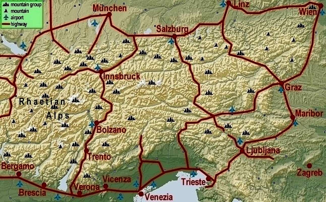
The Rationale Of This Page
I am the first advocate of the principle that on SummitPost the vast majority of pages should refer to distinct mountains. But as the number of mountain pages is growing it is more and more hard to find the relevant information. One interesting aspect of organizing SP pages is the geographical one. But our first job is to find agreement among SP members about the structure of mountain groups. Our experience with Dolomites was great. There we agreed on the structure of subgroups, after that agreement great work was done on further subgroup pages and on pages of distinct mountains. So, ideally in future we shall perhaps have the following structure: Alps (Eastern) page -> groups pages -> subgroups pages -> mountains pages -> (routes pages).
So I would like to offer SP members an option to start 'travelling' through Alps by simply clicking on the map above. This will bring you on mountain groups, if they are big enough and well organised, they will allow you to travel further to subgroups. And from there you will go to distinct mountain pages, which is what you initially wanted. And you may allways use links to go up the mentioned geographical hierarchy. And, I must admit, one purpose of this page is also to set a model how to structure bigger mountain areas on SP. Knowing for example almost nothing about mountains of East Africa, I would with great pleasure 'travel' through them on such a geographical way.
The Present Structure
For a start of Alps grouping structure I used Mathias Zehring's proposal, using bigger mountain groups, whenever appropriate (e.g. Dolomites, Hohe Tauern). I shall be more than happy to change this structure if our discussion leads towards a better solution. So please give me your feedback, here or on the Europe discussion board. Just make a note, for example: "In Silvretta group link to Piz Linard instead of Piz Buin" or propose a new grouping structure. I shall also track changes on SP and adapt the interactive map to newly occuring SP pages.
- Mountain groups, represented on SP with their own group page are indicated on the map with the group symbol. It links to the relevant SP group page. There's also one broad group in the western part - the Rhaetian Alps group.
- Currently the majority of groups doesn't have their group page on SP yet. In these cases I linked to the highest summit of the group, if it has its own SP page, or to any other summit, belonging to that mountain group. Once you find yourself in the area it will not be hard to find other nearby mountains.
- For some mountain groups I couldn't find any SP mountain page. For these, there's no symbol on the map. Because changing the map, uploading it on SP and making appropriate links is a tedious job, I shall implement changes only after more proposals are agreed upon.
A Table of Groups, Highest Summits and Current SP Links
| Eastern Alps Group | Highest Summit | Current SP Link |
| Bregenzerwald | Glatthorn (2134 m) | Bregenzerwaldgebirge |
| Allgaeu Alps | Grosser Krottenkopf (2657 m) | Allgaeu Alps |
| Lechquellen Group | Untere Wildgrubenspitze (2753 m) | Lechquellengebirge |
| Lechtal Alps | Parseierspitze (3036 m) | Lechtal Alps |
| Wetterstein | Zugspitze (2963 m) | Wettersteingebirge |
| Mieming Range | Hochplattig (2768 m) | Mieming Range |
| Karwendel | Birkkarspitze (2749 m) | Karwendel |
| Rofan | Hochiss (2299 m) | Hochiss (2299 m) |
| Ammergau Alps | Daniel (2342 m) | Ammergau Alps |
| Bavarian Pre-Alps | Krottenkopf (2086 m) | Bavarian Pre-Alps |
| Kaiser | Ellmauer Halt (2344 m) | Kaisergebirge |
| Steinberge | Birnhorn (2634 m) | Steinberge |
| Berchtesgaden Alps | Hochkoenig (2941 m) | Berchtesgaden Alps |
| Chiemgau Alps | Sonntagshorn (1961 m) | Chiemgau Alps |
| Salzburger Schieferalpen | Hundsstein (2117 m) | none |
| Tennengebirge | Raucheck (2431 m) | Tennengebirge |
| Dachstein Group | Hoher Dachstein (2995 m) | Hoher Dachstein (2995 m) |
| Totes Gebirge | Grosser Priel (2523 m) | Grosser Priel (2523m) |
| Ennstal Alps | Hochtor (2365 m) | Ennstal Alps |
| Salzkammergut | Gamsfeld (2028 m) | Gamsfeld (2028 m) |
| Oberoesterreich Forealps | Hohe Nock (1963 m) | Traunstein (1691 m) |
| Hochschwab Group | Hochschwab (2277 m) | Hochschwab (2277 m) |
| Muerzsteg Alps | Hohe Veitsch (1981 m) | Hohe Veitsch (1981 m) |
| Rax-Schneeberg Group | Klosterwappen (2076 m) | Klosterwappen (2076 m) |
| Ybbstal Alps | Hochstadl (1919 m) | Oetscher (1893 m) |
| Tuernitz Alps | Grosser Sulzberg (1400 m) | none |
| Gutenstein Alps | Reisalpe (1399 m) | Gutensteiner Alpen |
| Wienerwald | Schoepfl (893 m) | Wienerwald |
| Raetikon | Schesaplana (2965 m) | Schesaplana (2965 m) |
| Silvretta | Piz Linard (3411 m) | Silvretta Group |
| Samnaun Group | Muttler (3294 m) | Samnaun Group |
| Ferwall Group | Hoher Riffler (3168 m) | Ferwall Group |
| Sesvenna Group | Piz Sesvenna (3205 m) | Sesvenna Group |
| Oetztal Alps | Wildspitze (3770 m) | Oetztal Alps |
| Stubai Alps | Zuckerhuetl (3505 m) | Stubai Alps |
| Sarntal Alps | Hirzer (2741 m) | Sarntal Alps |
| Tux Alps | Lizumer Reckner (2884 m) | Tux Alps |
| Kitzbuehel Alps | Kreuzjoch (2558 m) | none |
| Zillertal Alps | Hochfeiler (3510 m) | Zillertal Alps |
| Hohe Tauern | Grossglockner (3798 m) | Hohe Tauern |
| Niedere Tauern | Hochgolling (2863 m) | Niedere Tauern |
| Gurktal Alps/Nockberge | Eisenhut (2441 m) | Gurktal Alps/Nockberge |
| Lavanttal Alps | Zirbitzkogel (2396 m) | Lavanttal Alps |
| East of Mur Forealps | Stuhleck (1782 m) | Stuhleck (1782 m) |
| Ortler Alps | Ortler (3905 m) | Ortler-Cevedale Group |
| Sobretta-Gavia Group | Monte Sobretta (3296 m) | none |
| Nonsberg Group | Grosse Laugenspitze (2433 m) | Nonsberg Group |
| Adamello-Presanella Alps | Cima Presanella (3556 m) | Cima Presanella (3556 m) |
| Lago di Garda Group | Monte Cadria (2254 m) | Monte Baldo / Altissimo (2218 m) |
| Brenta Group | Cima Tosa (3173 m) | Brenta Group |
| Dolomites | Marmolada - Punta Penia (3342 m) | Dolomites |
| Lagorai Group | Cima d'Asta (2847 m) | Lagorai |
| Prealpe Venete e Trentine | Cima Dodici (2336 m) | Prealpe Venete e Trentine |
| Gailtal Alps | Grosse Sandspitze (2770 m) | Gailtal Alps |
| Carnic Alps | Hohe Warte (2780 m) | Carnic Alps |
| Julian Alps | Triglav (2864 m) | Julian Alps |
| Karavanke | Stol/Hochstuhl (2237 m) | Karavanke/Karawanken |
| Kamnik and Savinja / Steiner Alps | Grintovec (2558 m) | Kamnik and Savinja / Steiner Alps |
| Plessura Alps | Aroser Rothorn (2980 m) | Mattjisch Horn (2460m) |
| Oberhalbstein Alps | Piz Platta (3392 m) | Valle Spluga GROUP |
| Albula Alps | Piz Kesch (3418 m) | Piz Kesch (3418 m) |
| Bernina Alps | Piz Bernina (4049 m) | Bernina Group |
| Val Masino Alps | Monte Disgrazia (3678m) | Val Masino Alps |
| Livigno Alps | Cima dei Piazzi (3439 m) | Livigno Alps |
| Lombardia Fore-Alps | Pizzo della Presolana (2521 m) | Prealpi Lombarde |
| Alpi Orobie | Pizzo di Coca (3050 m) | Alpi Orobie |
Geological Overview

|
|
Figure 1. Tectonic map of Alps - (1) Europe-vergent collisional belt: i) Western (WA) and Eastern (EA) Austroalpine; ii) Penninic domain: continental and ophiolitic (o) nappes in western Alpine arc (P) and tectonic windows (otw: Ossola-Ticino, ew: Engadine, tw: Tauern, rw: Rechnitz); Prealpine klippen (Pk); iii) Helvetic-Dauphinois (H-D) domain; iv) Molasse foredeep (M); v) Jura belt (J). (2) Southern Alps (SA), bounded to the north by the Periadriatic lineament (pl). Pannonian basin (PB), European (EF) and Po Valley-Adriatic (PA) forelands, Dinaric (DI) and Apenninic (AP) thrust-and-fold belts. Source: Dal Piaz, G.V., Bistacchi, A., Massironi, M., 2003.Geological outline of the Alps. Episodes26, 175–180. Picture shows that the geographical division on Western and Eastern Alps (roughly with the line EF-PA) is not in accordance with the geological one. Also the division of Eastern Alps on Southerm, Central and Northern Alps has only a rough match in the geological foundations. The so characteristic Southern Alps (Dolomites, Julian Alps, etc.) are not only in the Eastern part. Calcareous and dolomitic sediment rocks are stretching also far into the Western part. North of the Periadriatic Seam (pl) by a geographic classification we still have ranges of Southern Alps (for example Gailtal Alps). But geologically they belong to the Eastern Austroalpine formation. This one has a much different rock structure. On the south and on the north, its mountains are made of limestone and partly dolomite of various ages. That is why the southern sediment rock ranges are geographically attributed to the Southern Alps, and the northern sediment rock ranges of Austroalpine formation are geographically called Northern Limestone Alps (Wetterstein, Karwendel, Berchtesgaden Alps, Dachstein etc). Finally to mention in the Eastern Alps are the nappes of metamorphic cristalline rocks. The most characteristic are the Engadine window and the Tauern window. Geographically they form the Central part of the Eastern Alps, but not only them. Also east of Hohe Tauern the Austroalpine formation is made of a so-called basement rocks, which are not sedimentary. Only the Austroalpine cover has not broken, since from the Cretacious era on the central part of Alps is rising. It is also interesting, that you can often read that the big tectonic fault of Periadriatic Lineament (pl) is the place, where African and European continent are coliding. But that is not true. Many mountain ranges, lying north of it are parts of the African plate. Actually all sediments from the Triassic period were deposited in the ancient, southern lying Thetis sea, and since then on travelled towards the north. |
Language Variety in Eastern Alps
Brenta, our member in a good discussion about naming mountains in Alps wrote a nice description of this topic and agreed to copy a part of it here: ... The first people there of which we have historical records are the Raetii. There is no consensus on whether they spoke a language related to Etruscan or one of the Celtic family. Not even clear they should be considered one people. The Roman conquest was followed by colonization, which made Latin the spoken language. In the sixth century, as a result of the dissolution of the Roman central power, a kingdom of Bavaria formed, which included the region now known as Alto Adige/Suedtirol. The border was a line that was easy to defend. German-speaking people moved in, and the few surviving speakers of Latin retired to out-of-the-way valleys developing, over time, what is now Ladin. The ethnic and linguistic makeups of the region haven't shifted much since then, as far as I can gather, in spite of the many political changes. ...
The More Remote History of This Page
- June 5th, 2008 - Link to Livigno Alps page inserted.
- December 7th, 2007 - Link to the new page inserted: Lechquellengebirge.
- July 17th, 2007 - A few errors on the NE side corrected.
- June 2nd, 2007 - Link to the new page inserted: Gutensteiner Alpen.
- May 14th, 2007 - Links to new pages inserted: Kaisergebirge, Wienerwald.
- November 24th, 2006 - Links to new pages inserted: Tux Alps, Prealpe Venete e Trentine, Bavarian Pre-Alps, Mieming Range.
- May 20th, 2006 - Links to new pages inserted: Silvretta, Sarntal Alps, Ennstal Alps and Oetscher.
- March 28th, 2006 - Links to two new group pages inserted: Samnaun and Ferwall.
- March 18th, 2006 - Significant updates according to novelties, brought by SPv2.
- January 18th, 2006 - Links to the new pages inserted: Stubai Alps GROUP, Zillertal Alps GROUP, Monte Baldo / Altissimo.
- December 3rd, 2005 - Links to the new Grosser Ifinger page inserted.
- October 3rd, 2005 - Links to the new Stuhleck page inserted.
- September 28th, 2005 - Links to the new Birnhorn page inserted.
- August 31st, 2005 - Links to the new Ammergau Alps GROUP page inserted.
- August 30th, 2005 - Links to the new Allgaeu Alps GROUP page inserted.
- August 19th, 2005 - Linked Patscherkofel to represent the Tux Alps.
- July 23rd, 2005 - Switched the link from Sulzfluh to the new Schesaplana page to represent Raetikon.
- June 8th, 2005 - Links to the Cima Carega (Prealpi Veneti / Vicenza Alps) and Daniel (Ammergau Alps) page inserted.
- June 4th, 2005 - Link to the new Cima Carega page inserted (only in the table).
- April 18th, 2005 - Link to the new Lagorai page inserted, link on the map to the new Oetztal Alps GROUP.
- March 2nd, 2005 - Link to the new Berchtesgaden Alps GROUP page inserted.
- February 21st, 2005 - Link to the new Piz Kesch page inserted, representing Albula Alps.
- December 26th, 2004 - New map with the Gailtal Alps GROUP, links to Piz Linard, now representing Silvretta.
- December 20th, 2004 - Links to the new Gailtal Alps GROUP page inserted. Map still unchanged.
- December 1st, 2004 - A chapter about linguistic variety inserted.
- November 10th, 2004 - Links to the new Carnic Alps GROUP page inserted.
- October 21st, 2004 - Links to the new Pizzo di Coca page inserted, to represent Alpi Orobie.
- October 17th, 2004 - Link to the new Gurktal Alps / Nockberge GROUP page inserted. Map changed with links to this page and to the Lavanttal Alps GROUP page.
- October 11th, 2004 - Link to the new Lavanttal Alps GROUP inserted. Map still unchanged.
- September 3rd, 2004 - Interactive map updated with links: Grigne (Prealpi Lombarde), Arco & Val di Sarca climbing area (Lago di Garda Group), Pizzo del Diavolo di Tenda (Alpi Orobie). These respective links also added to the table.
- August 20th, 2004 - Inserted link to the new Reisskofel page, to represent Gailtal Alps. Interactive map updated with links: Reisskofel (Gailtal Alps), Koenigstuhl (Nockgebirge), Furggler (Samnaun Group).
- August 7th, 2004 - Inserted link to Furggler in table, to represent Samnaun Group (map not changed).
- June 27th, 2004 - Inserted link to Koenigstuhl in table, to represent Nockberge (map not changed).
- June 25th, 2004 - Interactive map updated (Niedere Tauern GROUP, Carnia Alps GROUP, Ortler/Ortles GROUP, Val Masino Alps GROUP, Seeboedenspitze).
- June 5th, 2004 - Link to the Niedere Tauern GROUP, map still not changed.
- June 2nd, 2004 - Interactve picture enhance (to show also mountain groups when pointing to symbols); plan for next steps.
- May 31st, 2004 - Initial set up of the page.
External Links
- Klettersteige Ostalpen Via-Ferrata.de - Klettersteigportal - Over 100 fixed rope routes. Moreover detailed information over climbing, alps, hiking and other outdoor activities.
- Overview map of the mountain groups of the eastern alps
- Steinmandl.de Lots of tour descriptions and pictures for the northern and central eastern Alps (Wetterstein, Karwendel, Kaiser, Ötztaler, Stubaier etc.) - In German
- Austrian Map online Online digital maps of Austria (OEK 50, OEK 200 and OEK 500) by the BEV (Bundesamt für Eich- und Vermessungswesen) - in German
mvs - May 26, 2006 1:15 pm - Voted 10/10
cool pageHi, could you update the interactive map and chart to signal the Bavarian Pre-Alps page. It doesn't have an owner, but there is a growing collection of peaks under it, a fair number more than the lone Krottenkopf that is standing in for this whole area. thx! --Michael
Vid Pogachnik - May 26, 2006 9:09 pm - Hasn't voted
Re: cool pageHm, yes Michael, but still, your request makes me some pain. You know the principle - on the map group pages are represented. In this case it's Bavarian Pre-Alps. As this page is still empty, I can't link to it. In such cases I link to the highest summit page, which is in this case Krottenkopf. I can't link to more mountains, even if there are pages of them. Yes, I saw you submitted and initiated a lot of nice summit pages. But they need to be encompassed in one group page.
mvs - May 27, 2006 6:37 am - Voted 10/10
Re: cool pageOkay, I will take ownership of Bavarian pre-alps page soon, and that will give us a solution. thx!
Mathias Zehring - Sep 11, 2006 8:42 pm - Voted 10/10
Mieming rangeAccording to the "Alpenvereinseinteilung" system Wetterstein & Mieminger buld one mountain group. But in fact they are two subgroups that both have their excellent page here. So I suggest to handle them as two groups here and give a link to the Mieming range page that is still missing.
Vid Pogachnik - Nov 12, 2006 12:53 pm - Hasn't voted
Re: Mieming rangeI hope it's done correctly. Thanks for reminding me again :)
mvs - Nov 12, 2006 7:37 am - Voted 10/10
2nd that!Hi yes I want to 2nd Matias's recommendation to add the Mieming Range page. It's very good and I like to browse "our neighborhood" with the interactive map image. But it doesn't have an icon for Mieming!
Vid Pogachnik - Nov 12, 2006 12:53 pm - Hasn't voted
Re: 2nd that!I hope it's done correctly. Thanks for reminding me again :)
mvs - May 14, 2007 2:47 am - Voted 10/10
KaisergebirgeHowdy Vid, can you update to include Gangolf's excellent Kaisergebirge page? http://www.summitpost.org/area/range/248374/kaisergebirge.html I use your interactive map as my way into the ranges. It's very useful!
Vid Pogachnik - May 14, 2007 2:33 pm - Hasn't voted
Re: KaisergebirgeDone! I don't know how I missed Kaisergebirge! I also made a link to the new Wienerwald page. Thanks for reminding me and for using my page :) Cheers!
DoJo - Jul 15, 2007 2:08 pm - Voted 10/10
errorsHi Vid I found some errors in the table of section 6 (A Table of Groups, Highest Summits and Current SP Links) Ötscher is part of the Ybbstal Alps - http://www.summitpost.org/mountain/rock/191247/-tscher.html Traunstein is part of the Oberoesterreich Forealps - http://www.summitpost.org/mountain/rock/151205/traunstein.html - Schneealpe is part of the Mürzsteger Alpen - http://www.summitpost.org/mountain/rock/155128/schneealpe.html you might add Grazer Bergland to "East of Mur Forealps"(http://www.summitpost.org/area/range/301949/Grazer-Bergland.html)
Vid Pogachnik - Jul 17, 2007 3:38 pm - Hasn't voted
Re: errorsThanks a lot! All done, except that I didn't add Grazer Bergland to East of Mur Forealps. It's an excellent page, but as Stuhleck is the highest summit and it already has its page, the link goes to it. I must soon update the map too. Cheers, Vid!
Ski Mountaineer - Jul 23, 2007 1:55 pm - Hasn't voted
Minor but......Graz has an airport too.
Vid Pogachnik - Jul 24, 2007 6:46 am - Hasn't voted
Re: Minor but......but important, I know. Thanks! I'll update the map and text. Graz is easy, Maribor is hard. You never know - now it has the airport, then it doesn't.