
-
 20894 Hits
-
 95.79% Score
-
 55 Votes
|
|
Area/Range |
|---|---|
|
|
47.34952°N / 10.94891°E |
|
|
Hiking, Mountaineering, Sport Climbing, Big Wall, Mixed, Via Ferrata, Skiing |
|
|
Spring, Summer, Fall, Winter |
|
|
9081 ft / 2768 m |
|
|
Overview
Mieming Range is not really a mountain group, but it is more than a sub-group. Its mountains belong to the Wetterstein Mountains. Mieming Range is a quite forgotten area and not as popular as Wetterstein Mountains (Zugspitze). The beauty of this range is outstanding. Unfriendly looking faces and peaks, meadows, lots of (seldom) plants and some crystal-clear lakes. To the north Gaistal (valley of the river "Gais") seperates Mieming Range from Wetterstein Mountains. To the east the next mountain group is Karwendel and Lechtaler Alps are close to the west. To the south Mieming Range has steep slopes down to the broad valley of the river Inn. On the other side of this valley the high peaks of Zillertal Alps, Stubai Alps and Ötztal Alps are completing the impressive panorama.
Mountains in the Mieming Range are very fragil. Because of beeing of limestone lots of rocks are loose, so on some mountains a helmet is necessary! In some parts in Mieming Range you feel like beeing in the Dolomites in Italy (but with the big pro, that you' re nearly alone!).
Mieming Range offer a lot of work for mountaineerers. In summer lots of hiking trails, via ferratae and climbing routes are waiting for you. In winter the peaks on the south side are very interresting, because of its splendid view and quite save slopes. The higher peaks are nearly not climbed in winter.
If you' re near this area and your arms and feet need something to do, Mieming Range has the right thing for you!
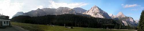 Ehrwalder Alm Panorama
Major Mountains of Mieming Range
Sorted by height, beginning with the highest peak.
| Hochplattig | Height 2768m / 9081ft, Latitude 47.34°N, Longitude 10.98°E Highest summit in the Mieming Range. Very huge peak with a distance of about 700m between east and west summit. The main summit is about in the middle between them. Because of its height very good views! Easiest route: via Henneberg. Trailhead in Mieming. Follow trail 12 to Boasligbrücke. From there trail 15 leads via Henneberg to the south slopes of Hochplattig (UIAA I, helmet!!). | |||
| Griesspitzen | Height 2747m / 9012ft, Latitude 47.35°N, Longitude 10.95°E Huge and rocky mountain, which offers no easy ascent. Seldomly climbed!
| |||
| Hochwand | Height 2719m / 8920ft, Latitude 47.35°N, Longitude 11.01°E Impressive peak with a gigantic north face (height: 1300m / 4265ft). Lots of climbing routes all over the mountain. Easiest route: Southern slopes. From Alplhaus trail 233 leads up to Karkopf. A unnamed trail turns left up to Hochwand (UIAA I) while trail 233 turns right.
| |||
| Mitterspitzen | Height 2688m / 8753ft, Latitude 47.35°N, Longitude 10.96°E Not as high as their closest neighbours but summitted seldomly. No really easy ascent! | |||
| Hohe Munde | Height 2662m / 8733ft, Latitude 47.33°N, Longitude 11.06°E Hohe Munde is an impressive stand-alone mountain. Its south face drops about 400m / 1321ft and the summit is about 2000m / 6561ft above the river Inn. Easiest route: East side. Trail 8 leads from Moos via Rauthhut to the summit.
| |||
| Grünstein | Height 2661m / 8730ft, Latitude 47.33°N, Longitude 10.92°E Highest peak of the western part of the Mieming Range. Splendid views towards Drachensee, Seebensee and Zugspitze. Easiest route: From Hölltörl (hell-gate) an unmarked trail leads up trough the Riffltal (UIAA I-II).
| |||
| Marienbergspitzen | Height 2561m / 8402ft, Latitude 47.35°N, Longitude 10.90°E Unfriendly looking mountain with a western and an (higher) eastern summit. Seldomly climbed, because of Grünstein, which is about 100m / 328ft higher and as difficult as Marienbergspitze. Easiest route: From Marienbergjoch a trail leads up a steep scree-field into a gully, which leads up to both summits.
| |||
| Wamperter Schrofen | Height 2520m / 8267ft, Latitude 47.36°N, Longitude 10.91°E Massife mountain with great faces and lots of climbing routes. Translating Wamperter Schrofen into english it means something like "bulbous rock". It got this name because of its huge and "bulbous" slopes to the west. Easiest route: From Coburger hut trail 814 leads to Biberwier Scharte. Not far from this pass a trail turns left (south), which leads via some rock steps (UIAA I-II) to the summit. | |||
| Wannig | Height 2493m / 8179ft, Latitude 47.33°N, Longitude 10.86°E Mountain on the west end of Mieming Range. Very popular because of its great views! Easiest route: From Nassereith trail 25 leads up to Muthenaualm. About 10min before you reach the hut trail 26 turns right (east) and leads up to the summit.
| |||
| Breitenkopf | Height 2469m / 8100ft, Latitude 47.35°N, Longitude 10.98°E Huge, but unimportant peak in the middle of Mieming Range. Because of its higher neighbours it is seldomly climbed. Easiest route: Follow Knappensteig (trail 34) from Ehrwalder Alm to Igelsee. A marked trail leads up to Breitenkopfhut and from there up the the south ridge of Breitenkopf. | |||
| Karkopf | Height 2469m / 8100ft, Latitude 47.35°N, Longitude 11.02°E Rectangular summit in the west of Niedere Munde with beautiful ascents. Traverse to Hochwand is possible. Easiest route: Southern slopes. From Alplhaus trail 233 leads up to Karkopf (UIAA I). | |||
| Tajakopf | Height 2450m / 8038ft, Latitude 47.35°N, Longitude 10.93°E This peak catches your eyes if you' re around Ehrwalder Alm. A famous and difficult via ferrata (Tajakante) leads up to the higher summit. Easiest route: Both summits of Tajakopf are easily reachable from Coburger hut via trail 812. A path to each summit turns leaves trail 812 on the left side. | |||
| Ehrwalder Sonnenspitze | Height 2412m / 7913ft, Latitude 47.36°N, Longitude 10.91°E The "Matterhorn of Ehrwald"! Spectacular and very exposed peak above Ehrwald. Easiest route: South slopes. An unmarked trail leads up from Seebensee. The descent route of the south - north traverse
| |||
| Drachenkopf | Height 2410m / 7906ft, Latitude 47.35°N, Longitude 10.92°E The hidden mountain of the Mieming Range - it can be seen from nearly nowhere (in the valey). Offers great views to the mountains around Coburger hut. Easiest route: South ridge. From Coburger hut trail 814 leads around the north face of Drachenkopf. Turn left and follow the red markings up to the ridge.
| |||
| Handschuhspitze | 2319m / 7608ft, Latitude 47.33°N, Longitude 10.87°E Unimportant peak, which is only (I think) climbed, if someone does the travers of Handschuhspitze to Wannig. Easiest route: From Marienbergjoch trail 30 leads up a steep scree-field. | |||
| Igelskopf | 2224m / 7296ft, Latitude 47.35°N, Longitude 10.97°E Small peak in near Breitenkopf. Very seldomly climbed! Easiest route: Follow Knappensteig (trail 34) from Ehrwalder Alm to Igelsee. A marked trail leads up to Breitenkopfhut. On the right side an unmarked trail leads up to the ridge to Igelskopf. | |||
| Wankspitze | 2209m / 7247ft, Latitude 47.33°N, Longitude 10.93°E Nice mountain with great views, a little via ferrata and a nice ski-tour. This summit gets crowded all the year! Easiest route: From Holzleiten (near Nassereith) trail 812 leads up to Lehnberghaus. From there trail 22 follows the southern slopes up to the summit. | |||
| Höllkopf | 2194m / 7198ft, Latitude 47.33°N, Longitude 10.92°E Same pros as Wankspitze, but without a via ferrata. Easiest route: From Marienbergjoch it is just a 1-2h walk along trail 29.
| |||
| Judenköpfe | 2021m / 6630ft, Latitude 47.33°N, Longitude 10.98°E Like the other to southern mountains (Wankspitze and Höllkopf), Judenköpfe offer great views and a nice ski-run in winter. Easiest route: From Alplhut trail 17A leads upp to Judenörl und further on to the summit. |


Arnstock subgroup
The Arnstock is a little subgroup at the east end of the Wetterstein. Most of its summit are in Austria. The highest peak of is on the border to Germany. Arnspitzhut is the only hut in this subgroup and it is a self supplier hut.Sorted by height, beginning with the highest peak.
| Grosse Arnspitze | 2196m / 7204ft, Latitude 47.3965°N, Longitude 11.2220°E Highest peak of this little subgroup. Easiest Route: From Scharnitz a trail leads west up to Arnspitzhut and from there to the summit.
| ||
| Arnplatten-Spitze or Hintere Arnspitze | 2170m / 7119ft, Latitude 47.3924°N, Longitude 11.2085°E From west and east an impressive peak with rocky faces. Despite of its look its summit isn' t that difficult. Easiest route: From the Hoher Sattel (reachable from Leutasch and Scharnitz) a trail leads north up to Arnplatten Spitze (UIAA I some places II).
| ||
| Mittlere Arnspitze | 2091m / 6860ft, Latitude 47.3944°N, Longitude 11.2169°E Summit between Grosse Arnspitze and Hintere Arnspitze. This peak is only done in combination with the Traverse of the Arnstock. Easiest route: Traverse of the Arnstock. | ||
| Arnkopf | 1934m / 6345ft, Latitude 47.3897°N, Longitude 11.2011°E Summit at the west end of this subgroup. Easiest route: From Leutasch (near Ahrn) a trail leads up to the summit. |


Huts overview
| 1506m / 4941ft, Self-supplier hut A key is required, which can be obtained from Section Munich of the German club of the Alps (DAV). | |
| 2040m / 6692ft, Self-supplier hut | |
| 1920m / 6299ft, open from June to Octobre (depending on weather conditions), Phone: +43 (0)664 3254714 Near the hut (about 10min to the south) are some climbing routes (UIAA III-VI, 1 and 2 pitches) available. | |
| 1493m / 4898ft, open from May to Octobre, Phone: +43 (0)5673 2534 There is a cable car from the parking lot in Ehrwald up to Ehrwalder Alm. | |
| 1366m / 5357ft, Bedrooms for 15 persons, open from May to Octobre, Phone: +43 (0)5214 5190 | |
| 1605m / 5265ft, open all the year, Phone: +43 (0)664 2815611 A chairlift carries you from the parking lot up to Rauthhut. | |
| 1622m / 5321ft, Some bedrooms (reservation needed!), open from May to Octobre, Phone: +43 (0)5265 5291 From the parking lot in Biberwier a cable car runs up to Marienbergjoch (about 20min from Marienbergalm). | |
| 1739m / 5705ft, NO bedrooms, open from June to Octobre, Phone: +43 (0)676 5568202 - Also named Muthenaualm | |
| 1575m / 5167ft, NO bedrooms, open from May to Octobre, Phone: +43 (0)676 3532013 | |
| 500m / 1640ft, NO bedrooms, open from May to Octobre, Phone: +43 (0)664 2735188 | |
| 1151m / 3776ft, boarding house The cable car up to Marienbergjoch has a "station" there. | |
| 1554m / 5098ft, reservation needed for overnight stay. The hut is about half-way between Grünsteinscharte and Obsteig, Phone: +43 (0)676 5344791 |
Routes overview
Description of trails that don' t belong to a specific mountain.
| Barberasteig | Hiking trail (number 51/813) from Biberwier to Marienbergjoch. |
| Biberwierer Scharte | Steep route from Biberwier to Coburger hut - Trailnumber 814 (later 28) |
| Ganghofersteig | Variant of trail 34 from Ehrwald to Coburger hut via Tajatörl |
| Grünsteinscharte | North-South connection from Coburger hut to Lehnberghaus |
| Hoher Gang | Shortest trail from Ehrwald to Coburger hut (number 37). |
| Immensteig | Interresting shortcut of trail 34 from Ehrwald to Coburger hut via Ehrwalder Alm |
| Knappensteig | Trail 34 is an easy "highway" to Coburger hut from Ehrwald via Ehrwalder Alm. Note: this trail is not steep, but very long (about 7km). |
| Niedere Munde | North-South connection from Gais-valley to Alphut |
Getting There
By car: By train:
For more information about getting there by train visit one of the following links:
ÖBB - Austrian train schedule.
DBahn - German train schedule.
Red Tape
There are no permits, fees or seasonal closures.In every city/town around Mieming Range parking is free (or if not, there are several possibilities of free parking!).
 |
When To Climb
The Mieming Range offers many possibilities of summiting all the year.In Summer every peak can be climbed. Some summits get a bit crowded on sunny days, if you' re on tour during weekends. From monday to friday you meet just a few people, if you' re not on the popular and easy mountains. On most of the mountains hiking gear is sufficient. A helmet may be useful on some mountains. Some peaks or routes upon them require climbing gear (rope, nuts, ...).
During winter the higher summits are quite dangerous, because of avalanches roaring down their steep slopes. Most of the lower peaks, especially on the south side of the Mieming Range, are very popular amoung skiers. If you try to reach the top of one of the higher peaks, you have to be sure that this terrain is easy for you and you have no problems in route finding or judging avalanche slopes.
Accomodation
The area of Seefeld and Ehrwald is very touristic. Several campsites and hotels can be found around this cities.For more specific information visit the homepage of Seefeld and Ehrwald.
Not every hut in the Mieming Range has bedrooms. I think camping on the mountain is not allowed (on the other hand I haven' t heard that it is forbidden...).
Look at "Huts overview" for more detailed information.
Mountain Conditions
Webcams:| Seefeld | Location: Seefeld (east end of Mieming Range), View direction: towards Hohe Munde. |
| Ehrwalder Alm | Location: Ehrwalder Alm (1500m / 4921ft), View direction: Different directions (picture and video stream). Displays current weather conditions (Temperature, humidity, wind speed). |
| Schneefernerhaus | Location: Zugspitze / Schneefernerhaus (2658m / 8720ft), View direction: Different directions (mostly east-south-east towards Hohe Munde). Good webcam to see snow conditions higher on the mountains. Sometimes Hochwand and/or Hohe Munde are visible. |
Weather:
| www.wetter.com (Ehrwald) | Ehrwald is located at the west end of Gaistal, which seperates Mieming Range to the south and Wetterstein massif to the north. |
| www.wetter.com (Nassereith) | Nassereith is a city south of Fernpass, which marks the west end of Mieming Range. |
| www.wetter.com (Mieming) | On the south side there are several towns and cities. The town of Mieming is about in the middle of Mieming Range. |
| www.wetter.com (Seefeld) | The city of Seefeld marks the east end of Mieming Range. |
Maps and books
Books:| Wetterstein mit Mieminger Kette Helmut Pfanzelt Bergverlag Rudolf Rother ISBN: 3-7633-3129-8 | Guidebook for Wetterstein and Mieming Range. The part of Mieming Range is a bit short, but every important mountain is in the book. |
| Mieminger Kette Rudolf Wutscher Bergverlag Rudolf Rother ISBN: 3-7633-1099-1 | Guidebook for Mieming Range only. About 200 pages of routes and information about mountains and the Mieming Range itself. Buy this book from Rother, unavailable at www.amazon.com |
| Kletterführer Bayerische Alpen – Nordtirol Richard Goedeke Bergverlag Rudolf Rother ISBN: 3-7633-3016-X | Guidbook for climbers. A few routes in the Mieming Range. Buy this book from Rother, unavailable at www.amazon.com |
Maps:
| 1:50 000 | - KOMPASS #5 - "Wettersteingebirge" |
| 1:25 000 | - Alpenvereinskarte 4/1 Wetterstein und Mieminger Gebirge, West - Western part of Mieming Range |
| - Alpenvereinskarte 4/2 Wetterstein und Mieminger Gebirge, Mitte - Central part of Mieming Range | |
| - Alpenvereinskarte 4/3 Wetterstein und Mieminger Gebirge, Ost - Eastern part of Mieming Range |