
|
|
Area/Range |
|---|---|
|
|
44.81700°N / 118.104°W |
|
|
9106 ft / 2776 m |
|
|
Overview
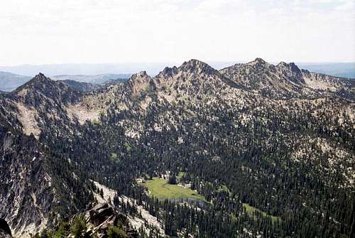
The Anthony Lake area peaks form the abrupt north terminus of the Elkhorns
Introduction
The Elkhorn Mountains are situated in the central portion of the extensive Blue Mountains that extend from southeast Washington into adjacent Oregon in a northeast to southeast orientation. The north portion of the high Elkhorn portion runs approximately from the junction of the Union, Granite and Baker county lines southward along the Baker/Grant county border before turning southeast for the central and southern portions of the main divide. The entire distance is approximately 23 miles. The Elkhorns are the highest subgroup of the Blues with most of the higher peaks rising at least 5,000 vertical feet over the floor of Baker Valley. Rock Creek Butte, the highest point at 9,106 feet rises approximately 5,600 feet with an impressive 4,466 feet of prominence.
 |
 |
 |
 |
 |
 |
 |
The central dividing ridge of the Elkhorns is referred to as the Elkhorn Crest and forms the divide between the Powder River basin to the east and south that flows into the Snake River and the John Day River basin to the west that drains much of central Oregon into the Columbia River. From the crest westward in the northern part of the range, the North Fork John Day Wilderness is situated. The east side of the crest is also primitive, but a few rough roads ascend some of the main canyons. Other parts of the east side may be at least as remote as the designated wilderness.
The Elkhorns offer a wide variety of activities, including hiking, fishing, developed and primitive camping as well as numerous peaks that require a wide variety of expertise to summit. The Elkhorn Scenic Byway also encircle the range, taking one through agricultural and low elevation forest areas up through the high subalpine adjacent the northern peaks. Several historical sites ranging from trains, mines and semi-ghost towns are also included. Anthony Lakes Ski Area is near the high point of the byway. This small ski resort is noted for great powder snow and claims the highest base in Oregon. The area is managed by the Baker Ranger District of the Wallowa-Whitman National Forest.
 |
 |
 |
 |
 |
 |
 |
Significant Peaks
This list contains all the summits in the Elkhorn Mountains that are named or have at least 300 feet of prominence and are over 8,000 feet in elevation. It is nearly a complete list because there are few summits that are of a lower elevation. Due to proximity to other points, a few of these would not make appropriate mountain pages, but would properly be grouped. There are many other point in the Elkhorns that do not meet the criteria for this list, but provide great hiking and climbing experiences.
 Rock Creek Butte Rock Creek Butte Red Mt Red Mt Van Patten Butte Van Patten Butte Lees Pk The Lakes LO Lees Pk The Lakes LO Pk 8525 Pk 8525 Van Patten Ridge east Van Patten Ridge east |
|
Elevation | Prominence | Lat./long. | |
| Rock Creek Butte | 9,106 | 4,466 | 44.817N 118.104W | ||
| Elkhorn Peak | 8,931 | 711 | 44.810N 118.075W | ||
| Red Mountain | 8,928 | 1,068 | 44.884N 118.170W | ||
| Twin Mountain | 8,897 | 1,477 | 44.928N 118.165W | ||
| Peak 8878 (Cougar Basin cirque E) | 8,878 | 738 | 44.834N 118.096W | ||
| Peak 8875 (Cougar Basin cirque W) | 8,875 | 455 | 44.831N 118.096W | ||
| Van Patten Butte | 8,729 | 1,309 | 44.950N 118.203W | ||
| Maxwell Mountain (Willow Lake cirque) | 8,709 | 484 | 44.862N 118.090W | ||
| Angell Peak | 8,646 | 706 | 44.942N 118.230W | ||
| Lees Peak | 8,626 | 286 | 44.943N 118.238W | ||
| Mount Ruth | 8,600 | 780 | 44.894N 118.232W | ||
| Peak 8564 (Chloride Ridge W) | 8,564 | 384 | 44.869N 118.166W | ||
| Peak 8538 (Antone Ck head) | 8,538 | 358 | 44.937N 118.224W | ||
| Peak 8525 (Dutch Flat head) | 8,525 | 625 | 44.924N 118.232W | ||
| The Lakes Lookout | 8,522 | 222 | 44.944N 118.243W | ||
| Peak 8486 (Summit Lake cirque) | 8,486 | 466 | 44.869N 118.193W | ||
| Peak 8428 (Dutch/Powder divide) | 8,428 | 528 | 44.917N 118.207W | ||
| Peak 8419 (Chloride ridge E) | 8,419 | 479 | 44.870N 118.136W | ||
| Van Patten Ridge east | 8,412 | 312 | 44.948N 118.136W | ||
| Peak 8357 (NF Rock Ck) | 8,357 | 637 | 44.848N 118.165W | ||
| Gunsight Mountain | 8,342 | 242 | 44.951N 118.228W | ||
| Mount Ireland | 8,321 | 1,061 | 44.837N 118.228W | ||
| Hunt Mountain | 8,225 | 505 | 44.871N 118.063W | ||
| Columbia Hill | 8,117 | 537 | 44.865N 118.228W | ||
| Peak 8116 | 8,116 | 336 | 44.926N 118.244W | ||
| Crown Point | 8,006 | 546 | 44.853N 118.294W |
 Elkhorn Peak
 Twin Mt
 Angell Pk
 Mt Ruth
 Summit Lake cirque
 Gunsight Mt
 Mt Ireland
North Fork John Day Wilderness

The Burned Wilderness
Designated in 1984 and located on the Baker Ranger District of the Wallowa-Whitman National Forest, the North Fork John Day Wilderness-Baldy Creek Unit covers 13,715 acres of the northern end of the Elkhorn Mountains. Several scenic subalpine lake basins characterize the glacially carved landscape that includes Bull Creek, Baldy Creek, and Crawfish Creek, and the headwaters of the North Fork John Day River. This unit along with three others on the adjacent Umatilla National Forest was selected to provide increased protection of the headwaters tributaries of the North Fork John Day River, which is a high priority basin for its high quality anadromous fisheries habitat.
Due to the small size of this wilderness, it may be difficult to find solitude unless one ventures away from the primary trails and lakes to seek the more remote corners and basins. The active recent fire history of the wilderness further contributes to the lack of apparent isolation because of the extensive opening created. The Sloan’s Ridge Fire of 1996 burned 7300 acres of the Baldy, Bull, and North Fork John Day drainages within the wilderness, and the Crawfish Prescribed Natural Fire, burned 516 acres around Crawfish Lake in 1995. There were also extensive fires in the mid-1980s. As a result, almost the entire wilderness adjacent the Elkhorn Crest has been burned and is now an expansive, open stand of dead timber. Though an important wilderness, this is not the best part of the Elkhorns to visit.
Access to points around the small wilderness provides a number of easy day hikes and short trips into the area. To experience this wilderness at its finest plan on hiking the length of the Elkhorn Crest Trail that follows the entire length of the high dividing ridge on the east wilderness boundary. Branching off from this are more than 100 miles of trail for hikers and horseback riders to explore.
Wild and Scenic Rivers
North Fork John Day River

North Fork John Day River Canyon
In 1988 approximately 54 miles of this river was designated as wild, scenic or recreational, largely to protect important fisheries and habitat. The John Day is the only undammed major river basin in the state, and the North Fork John Day River supports the largest and most important run of anadromous fish within this Basin. The North Fork and its tributaries support an estimated 70% of the total spring chinook salmon run and 43% of the summer steelhead run within the subbasin. This is the largest spawning population of wild spring chinook and summer steelhead in the Columbia River system. The genetic integrity of the runs is unique compared to the majority of Columbia River Basin anadromous fish runs, which are supplemented by hatchery fish or were established from non-native stocks. The upper North Fork John Day River is thought to have one of the few remaining healthy bull trout populations in the state. According to fish biologists, there is a high probability that redband trout also is present in conjunction with rainbow trout in the North Fork John Day River.
The diverse landscape and geologic formations of the John Day canyon create high quality natural scenery. Manmade developments have a primitive or historic appearance, including early day mining remains. There is a great deal of history from the gold mining era tied to this area, which began in the 1860's. Recreation opportunities include hunting, fishing, sightseeing, horseback riding, hiking, snowmobiling, skiing, camping, and whitewater rafting.
North Fork North Powder River

North Fork Powder River Canyon
The river originates near Cracker Saddle high on the Elkhorn Ridge of the Blue Mountains at nearly 8,000 feet. It is a glaciated valley characterized by craggy mountain tops reaching above timberline, cirque basins, subalpine lakes, and precipitous streams. The river's name is derived from the Chinook jargon words "polallie illahe." This translates as "sandy" or "powdery ground", which describes the soils along the stream. A total of six miles are designated from its headwaters to the Wallowa-Whitman National Forest boundary.
Recreational use includes hunting, fishing, camping, motorbikes, four wheel drives or ATV's, hiking, backpacking, mountain biking, and horse packing. The river is too small, however, for boating. The steepness of the canyon precludes much winter recreation, but some snowmobiling and cross country skiing does occur. Though not designated as wilderness, the east side of the Elkhorn Crest offers some of the most beautiful and primitive ground in the Elkhorns. Also, the fires that ravaged the west side of the divide have only slopped over in a few places, leaving the Powder River side much greener and more scenic.
Access

Rock Creek
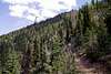
The Elkhorn Scenic Byway (road 73) around the north and west perimeters of the range provides access to the trailheads in the Anthony Lake vicinity and most of the trails into the North Fork John Day Wilderness. Several secondary roads off the southern section of the Elkhorn Scenic Byway (Highways 24 and 7) provide access to the southern points. Utilize maps and local information to plan your trip well in this area because there are many old mining roads to get lost on. The eastern portions of the Elkhorns are accessed by roads and trails up the Dutch Flat, North Fork Powder, Rock Creek, Pine Creek and Marble Creek drainages. Most of these access points are reached via routes that pass through heavily roaded farm and ranch country. Some homework and planning is a good idea to know how to get there.
Refer to the Baker Ranger District column for a list of trails that access the Elkhorns. Each link provides such directions to the trailhead, trail conditions, length, difficulty, restrictions, attractions etc. Whether a parking pass is required is also included in the trail descriptions.
Geology
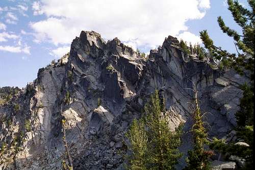
Rugged granite on the north face of The Lakes Lookout
The rocks of the Elkhorn Mountains are formed of two terranes. These bisect the north-south orientated mountains, with most of the area being over the southern rocks, known as the Baker terrane. The Baker terrane is largely composed of argillite rock that was formed from metamorphosed mud and chert originally deposited in deep ocean environments during Permian and Triassic times. Other sedimentary rocks included in small bodies of limestone, tuff, and conglomerates. The northern rocks were part of the Northern Arc terrane that contains material very similar to the Wallowa and Seven Devils rocks and may in fact be continuous with them, but the intervening area is covered up by flood basalts.
Both of these terranes lodged against the North American continent as the ocean floor between them sank into the trench. The northern part of the Elknorns now consists of intrusive rocks of the Anthony Lake Granidiorite Formation of the Bald Mountain Batholith. This mass of granitic rock extends over 144 square miles and is the dominant material throughout the northern portion of the mountains. Columbia River flood basalts that covered much of the inland northwest including much of the lower adjacent areas are not part of the high terrain of the Elkhorns.
The Pleistocene Ice Age sculpted the glacial landscape found today. Glacial till, with its mixed layers of fine sand and large boulders, can also be seen in the upper drainages. Many of the rock units have been metamorphosed, faulted, and folded producing a variety of shapes and colors. Layers of ash (probably from Mt. Mazama) 7-14" thick can be found in places. Recent natural debris flows from side drainages that occurred after the large forest fires of the 1980s and 1990s are an ongoing process shaping the land.
 |
 |
 |
 |
 |
 |
 |
History

Mining Country
The mountains and surrounding valleys were utilized by the Umatilla, Nez Perce, Shoshone-Bannock, and Northern Paiute Indians to gather, hunt, and fish. In 1811 the first non-Indians to see the Elkhorn Mountains were members of the Hunt expedition as they traveled through the Powder River valley. This valley was also provided passage for the Oregon Trail and some travelers settled here and the nearby Grande Round valley to the north.
Gold mining was the primary activity which first brought substantial numbers of people to the mountains in the 1860's, and evidence of this gold rush still exists primarily in the southwest portion of the Elkhorns. Other minerals such as silver, copper, lead, zinc, chromite and manganese were produced in small quantities. Evidence of this history includes cabins, mines, prospect holes, ditches and other related developments. It is not unusual to find traces of these activities in the mountains in remote locations as well as near some of the small surviving towns or ghost towns of the area. Possibly the earliest route over the Elkhorns survives today as the road up the North Fork Powder River that extended west through Cracker Pass to the mining towns of Bourne and Sumpter. This road was originally constructed in 1864 by the Dealy Wagon Road Company. It was a difficult route that wasn’t used heavily and soon easier alternate routes were constructed elsewhere. Today the road can be driven most of the way up the basin, but is managed as a trail over Cracker Pass.
Climate

The Lakes LO
Several local climatic zones are represented in northeast Oregon resulting from the extremes in elevation, geographic variation, and topographic diversity throughout the area. Deep canyons in close proximity to high mountains often create climatic variations over short distances. However the major influence to the regional climate comes from the Cascade Mountains lying nearly 200 miles to the west. This mountain range forms a barrier against modifying effects of moist winds from the Pacific Ocean and, as a result, the climate of the area is essentially dry. In general the climate for much of the area is categorized as temperate continental. Light precipitation, low relative humidity, rapid evaporation, abundant sunshine, and wide ranges in temperature are characteristic for this climate type. The north end of the mountains is slightly moister, being closer to the maritime air flows that pass through the Columbia River Gorge. But there are marked local differences in temperature and precipitation owing to local topography.
The Elkhorn Mountains 30 to 40 inches of precipitation per year. The heaviest precipitation is generally in winter with a secondary period of high precipitation occurring in May and June when spring rains or wet snows fall in the mountains. The area is often under the influence of a continental anticyclone that results in high pressure air masses that produce clear skies, lack of cloud cover, and extremely cold temperature. Summer temperatures are often in the 70s and 80s, while night time lows are generally in the 40s, though it can dip below freezing any time of the year.
Flora

Glandular Paintbrush
The vegetation of the Elkhorn Mountains is relatively simple, being composed mostly of assorted forest types with a few more specialized communities. Due to the prevailing continental climate most of the forests are relatively dry and warm or dry and cold as elevation increases. The lower slopes support open forests of Ponderosa pine with open sage shrublands. Some juniper also occurs at the lower, open sites. The forest transitions to Douglas fir, white fir and lodgepole pine as elevation increases. The highest subalpine slopes support open parklands of subalpine fir and whitebark pine. This area is generally characterized by open slopes, rock slides, stunted trees, low shrubs, and herbaceous plants. There is no upper climatic timberline in the Elkhorns as the trees, though very stunted go to the tops of the highest mountains unless precluded by rocks.
Cold forests of subalpine fir and Engelman spruce also are common in the bottoms of the larger mountain valleys because this is a position that collects cold air, which favors these species. North slopes support western larch, which being a deciduous conifer, provide spectacular displays of gold mixed in with the green forest in the fall. Montane grasslands are virtually absent and such open sites that normally would support this habitat in more northern mountains are dominated by sage. This is a product of the drier continental climate.
There are few specialized vegetation types in the range. The northern areas are slightly moisture being closer to the maritime air flows that find passage east through the Columbia River Gorge. These mesic north slopes support such species as Menziesia, Rhododendron, twin flower and Labrador tea. Open scree slopes and ridge crests are sites that support species adapted to open soils and a harsh environment. Interesting species found on these sites include alpine collomia and Ross’ avens, which is a rare species disjunct from the main Rocky Mountains. Glandular Indian paintbrush only grows in the Elkhorn and nearby Strawberry Mountains. And the global distribution of one species of lomatium is limited to the summits of a few of the highest Elkhorn peaks. Moist meadows and wetlands are found in some of the valley bottoms and adjacent some subalpine lakes. These sites are important for floral diversity, hydrologic function and wildlife habitat.
 |
 |
 |
 |
 |
 |
 |
 |
Fauna
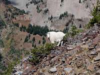
Mountain Goat
Wildlife is diverse, and in general, excellent habitat exists in the Elkhorns for big-game species, such as Rocky Mountain elk and mule deer which summer in the high mountains and winter on the lower, warmer slopes. There are moderate numbers of black bear and bobcat and cougar populations are on the rise since hunting them with dogs was discontinued in the 1990s. This increase in predator population has resulted in some decline in big game numbers. Little is known about the resident wolverines; populations most likely are low. Pronghorn antelope are slowly returning to the foothills and they are an occasional site in the open country at the western and southern base of the mountains. (One of the most fascinating things I ever saw was in a broad meadow west of Sumpter where 5 sand hill cranes, 7 antelope and 3 coyotes all stood intermixed in close proximity and apparently indifferent to each other. Of course I did not have the camera that day).
The huge amount of dead and dying trees due to insect infestations and recent fires have created very good habitat for a variety of woodpeckers, gray owls and song birds. The burned areas also provide a diversity of habitat and excellent forage for deer and elk. Bald eagles, peregrine falcons, goshawks, and other uncommon birds are known to utilize the area, as well as small mammals such as mink, beaver and possibly the otter. Wolves are not considered to be present, however at least four are known to have dispersed from the expanding Idaho populations to this part of Oregon. Two were killed by cars near Baker City, while two others have been recaptured west of the Elkhorns are returned to Idaho. It is probable that others have come into the area and escaped detection.
Lakes
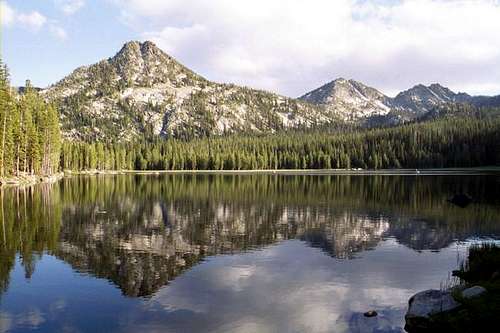 Gunsight Mountain, Lees Peak, The Lakes LO reflected in Anthony Lake
Depending on how they are counted there are approximately 34 lakes or larger ponds in the Elkhorn Mountains. There is no clear division between what a lake is and what is a pond, but the list attempts to be fairly inclusive, though some ponds were definitely left out. Due to their scenic beauty and prime camping locations, the lakes of the Elkhorns are popular destinations for recreationists who come to the mountains in increasing numbers every year. A few are very remote and are rarely visited, but some of the more popular bodies, especially around Anthony Lake can be overrun with crowds on holidays and nice weekends.
Most of these lakes are in glacial cirques or tarns. Few if any of the high lakes supported fish populations historically, but today have been planted with rainbow trout, cutthroat trout, and brook trout. Many of the lakes have had their outlets regulated with damn-like structures to control the flows during the summer for irrigation purposes in the agricultural Baker Valley below.
In the following table the lakes are arranged alphabetically and elevations for each body of water are given, but some of these are approximate.
Anthony Lake7,131Baldy Lake7,121Black Lake7,344Bucket Lake7,836Cougar Basin ponds (3)7,940Crawfish Lake6,883Downie Lake6,600Dutch Flat Lake7,326Goodrich Lake6,871Grande Ronde Lake7,146Hoffer Lakes (2)7,472Killamacue Lake7,137Lilypad Lake7,135Little Summit Lake6,928Lost Lake7,363Meadow Lake7,172Mud Lake7,091Red Mountain Lake7,123Rock Creek Lake7,660Summit Lake7,247Twin Lakes (2)7,701Unnamed (Angell Pass)7,795Unnamed (Antone Ck head)7,500Unnamed (Crawfish Basin)7,147Unnamed (Lees Peak)7,860Unnamed (Marble Point)6,800Unnamed (Mt Ireland)7,550Unnamed (west Rock Ck Lake)7,620Van Patten Lake7,396Willow Creek Lake7,919
 Anthony Lake Anthony Lake Twin Lakes Twin Lakes Lower Twin Lower Twin Van Patten Lake Van Patten Lake |
|
Elevation |
 Rock Ck Lake
 Black Lake
 Lower Hoffer
 Anthony/Hoffer Basins
Camping

Gunsight Mt and Black Lake
Most developed campgrounds in the Elkhorns are found at the northern end around the Anthony Lake vicinity and at the southern end associated with Phillips Lake. Information for campgrounds and picnic areas in the Elkhorns can be found on the Wallowa-Whitman National Forest web page and includes location, access, fees, services provided, photos, attractions and more.
More primitive camping is allowed almost anywhere, but most areas must be backpacked to. Some dispersed camping can be found off the rough dirt roads wherever these enter the mountains. The roads entering the Rock Creek and North Fork Powder River canyons are probably the most popular for this.
Red Tape
The standard wilderness regulations apply for the North Fork John Day Wilderness. Primarily there is no motorized or mechanized equipment (this includes bicycles and hang gliders), and no commercial activities. Also strongly recommended is limiting group size to less than 12 people and not camping near lakes or sensitive meadows.
The Elkhorn Crest trailhead requires a Northwest Forest Pass ($30 per year) or a National Forest Day Pass ($5 per day). Other trailheads may require a trailhead parking pass. Enquire at the offices listed below to see if a pass is necessary for your destination.
Additional Information and Current Conditions
[img:206930:alignright:small:lower Twin Lake]
Wallowa-Whitman National Forest Headquarters
P.O. Box 907 / 1550 Dewey Avenue
Baker City, Oregon 97814
(541) 523-6391
TDD (541) 523-1405
Baker Ranger District
3285 11th St.
P. O. Box 947
Baker City, Oregon 97814
(541) 523-4476
Current Conditions
NOAA Forcast
References
Northwest Exposures. A Geologic Story of the Northwest, by David Alt and Donald Hyndman.
ISBN: 0878423230
Alpine and Subalpine Vegetation of the Wallowa, Seven Devils and Blue Mountains, by Charles Johnson.
USDA Forest Service publication, R6-NR-ECOL-TP-03-04