
-
 68625 Hits
-
 88.49% Score
-
 27 Votes
|
|
Area/Range |
|---|---|
|
|
44.11250°N / 73.9239°W |
|
|
Hiking, Mountaineering, Trad Climbing, Ice Climbing, Scrambling, Skiing |
|
|
Spring, Summer, Fall, Winter |
|
|
5344 ft / 1629 m |
|
|
Introduction
The Great Range is an 11-mile contiguous chain of mountains in the heart of the High Peaks region of the Adirondacks, unofficially consisting of the following peaks (see Children list to left for links to individual mountains):
Snow
Roostercomb
Hedgehog
Lower Wolfjaw
Upper Wolfjaw
Armstrong
Gothics
Pyramid
Sawteeth
Gooseberry
Saddleback
Basin
Little Haystack
Haystack
Little Marcy
Marcy
Gray
Skylight
Redfield
Little Nippletop
McDonnell
Allen
Bold = High Peak as defined by Adirondack Mountain Club.
The Peaks
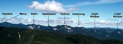
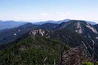
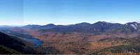
Panorama of Upper and Lower Portions of the Great Range
Lower Range
The northern portion of the Range is typically called the Lower Range, and consists of the following mountains: Snow, Roostercomb, Hedgehog, Lower Wolfjaw, Upper Wolfjaw, Armstrong, Gothics, Pyramid, and Sawteeth. The Lower Range is well-defined by natural borders to the southwest (valley containing the East Branch of the Ausable River, and Upper and Lower Ausable Lakes), northeast (Ausable Valley including NYS Route 73, and northwest (Johns Brook Valley).
Upper Range
The middle portion, consisting of Gooseberry, Saddleback, Basin, Haystack, Little Haystack, and Mt. Marcy, is commonly referred to as the Upper Range. The northwest and southeastern borders of the Upper Range are still well defined by the Johns Brook and Upper Ausable Lake valleys, respectively. Some believe that Haystack is not part of the Great Range. In the author’s opinion, this mindset is erroneous, since Basin is directly connected to Mt. Haystack, not Mt. Marcy. Others believe that Sawteeth should not be included in the Range. Although Sawteeth does not lie on the “spine” of the Range, it is definitely located within the pre-defined borders of the Range.
Southern portion of Range
The borders of the southern section of the Great Range are quite vague. One reason for this vagueness is Panther Gorge, a deep ravine located between Haystack and Marcy to the northwest, and Haystack and Allen to the southwest. This chasm can appear to divide two separate mountain ranges, but if the reader views a topographic map at 1:100,000 scale, a clear spine can be seen extending from Hedgehog to Allen. The spine just has some severe scoliosis near Panther Gorge. Therefore, the author has included the following southern mountains in the Great Range group: Little Marcy, Marcy, Gray, Skylight, Redfield, Little Nippletop, McDonnell, and Allen.
In the author’s opinion, topography and/or distance exclude Tabletop, Colden, Cliff, and North River Mountains from the Great Range group.
When To Climb
Early Spring: Locally known as mud season. Expect lots of mud, crappy snow conditions, and swollen water crossings; all of which will slow your pace. Due to erosion concerns, NYS Dept of Environmental Conservation discourages elevation hiking during this time of year.
Late Spring: Blackfly season typically runs from late May to early July; which may accelerate your pace to a jog. Get an early start and hike while they're groggy from the cool morning temperatures.
Summer: Be prepared for mosquitoes and deerflies in lower, flat sections. This time of year can be hot and humid. Bring lots of water. There is little, if any, water once on the Range itself. Summer haze may obscure views. Due to heat and humidity, early starts are better. Lightning can be a concern on the Range, especially above treeline. Long daylight hours improve the chances of completing a Range Traverse.
Early Autumn: Spectacular foliage from late September to early October. Be prepared to be slowed by swarms of motor-tourists and hikers. No bugs, cool temps, dry trails… a nice time to attempt a Range Traverse.
Late Autumn: Due to freeze/thaw effects, trails are often icy. However, early season storms can dump significant snow at elevation. Author has experienced 3+ feet of newly fallen snow in late October. Due to ice, crampons may be necessary on the summit ridges. Some may opt for an ice axe, especially for Saddleback and Gothics. Trails are not regularly broken until the “official” beginning of the winter season (December 21), when aspiring Winter 46ers are stirred from their warm homes. Typically, November and early December are cloudy.
Winter: Late December and early January are typically cloudy. Skies begin to brighten in mid-January, and February can be quite sunny. Trails are typically well packed at this time. Clouds begin to move in again in mid-March. Days can be crystal clear, or white-out conditions, or both. Due to wind effects, crampons or aggressive snowshoes may be necessary on the summit ridges. Some may opt for an ice axe, especially for Saddleback and Gothics. Don’t let the not-so-lofty elevations of the Adirondacks fool you… nearby Saranac Lake often makes the national news by being the coldest place in the continental US.
Current Mountain Weather: >http://www.erh.noaa.gov/btv/mountain/point/
Forecast for Lake Placid at Weather Underground
Snow Depth (be sure to change the date!)
Recent Trail Conditions at Views From the Top
Trailheads
Please refer to individual mountains for trailhead/parking details.
Elk Lake Trailhead - Access to Panther Gorge
Upper Works - Access to the southern portion of the Range
St. Huberts - Access to the southeastern flanks of the Great Range, good starting/end point for Lower Range loop, good starting/end point for partial Lower Range loop
Roostercomb - Access to the northeastern terminus of the Great Range, good starting/end point for Great Range loop
Snow - Access to the northeastern terminus of the Great Range, good starting/end point for Great Range loop
Garden - Access to the northeastern terminus of the Great Range, good starting/end point for Great Range loop, good starting/end point for partial Lower Range loop, good starting/end point for Upper Range loop
Garden Overflow Parking - Bus shuttles between Marcy Field (just north of Keene Valley) and the Garden
Major Trails
| Section | Trail Name |
| Roostercomb Trailhead to Hedgehog | Unnamed Adirondack Trail Improvement Society trail |
| Hedgehog to Lower Wolfjaw | W.A. White Trail |
| Lower Wolfjaw Col to Gothics/Saddleback Col | ADK Range Trail |
| Gothics/Saddleback Col to Marcy | State Range Trail |
| Marcy to Garden | Phelps Trail |
Great Range Traverse
Ask ten people what constitutes a Great Range traverse, and you'll likely get ten different answers. However, complete the following, and I doubt anyone will argue with you. Although most hike in the order I provide, the route can be completed just as "easily" in the opposite direction.
Before hitting the trail, you should be aware of a few things:
- Backpacker magazine rated this route as the third hardest dayhike in America
- Except for Marcy and Roostercomb, each of these mountains has a double peak, which gets annoying at the end of a very long day
- Gothics, Basin, Haystack, and Marcy have significant areas above treeline
- There are rock ledges on all of the mountains that require scrambling. Many of these ledges will be difficult to negotiate with a backpack
- The exposure on the west slope of Gothics is significant. The DEC has installed cables on this side of the mountain to provide a feeling of security. Although the author does not think that the cables are necessary, they could be helpful in wet or verglas conditions, or to the faint of heart.
- There are cliffs on the west side of Saddleback. If you lose the trail down the cliffs, you may find yourself executing some Class 4 or 5 moves.
- Roostercomb provides some great views from its bald peak
- The views from Pyramid are arguably the best in the Adirondacks... not to be missed
- The views of Marcy and Panther Gorge from Haystack are breathtaking
- Bring plenty of water, since there is virtually none on the Range (if you're lucky, you might find some in Haystack Brook). Either pack it with you, or be prepared to descend about 500 feet down sidetrails in search of some.
| Section | Total | Section | Total | ||
| Location_________________ | Mileage_____ | Mileage_____ | Ascent(ft)_____ | Ascent(ft) | |
| Roostercomb Trailhead | 0.0 | 0.0 | 0 | 0 | |
| Roostercomb Junction | 2.0 | 2.0 | 1,470 | 1,470 | |
| Hedgehog | 1.1 | 3.1 | 1,060 | 2,530 | |
| Lower Wolfjaw | 1.9 | 5.0 | 1,140 | 3,670 | |
| Col | 0.5 | 5.5 | -675 | 3,670 | |
| Upper Wolfjaw | 0.9 | 6.4 | 800 | 4,470 | |
| Col | 0.2 | 6.6 | -300 | 4,470 | |
| Armstrong | 0.8 | 7.4 | 500 | 4,970 | |
| Col | 0.4 | 7.8 | -200 | 4,970 | |
| Gothics | 0.5 | 8.3 | 500 | 5,470 | |
| Col | 0.6 | 6.9 | -750 | 5,470 | |
| Saddleback | 0.5 | 9.4 | 600 | 6,070 | |
| Col | 0.8 | 10.2 | -400 | 6,070 | |
| Basin | 0.7 | 10.9 | 700 | 6,770 | |
| Col | 0.8 | 11.7 | -1,050 | 6,770 | |
| Haystack Ridge | 0.7 | 12.4 | 850 | 7,620 | |
| Col | 0.4 | 12.8 | -450 | 7,620 | |
| Marcy | 1.3 | 14.1 | 1,200 | 8,820 | |
| Garden | 9.1 | 23.2 | -3,820 | 8,820 | |
| Roostercomb Trailhead | 2.1 | 25.3 | -430 | 8,820 | |
| Extra Credit | |||||
| Roostercomb Spur | 1.0 | 26.3 | 300 | 9,120 | |
| Pyramid Spur | 0.6 | 26.9 | 400 | 9,520 | |
| Haystack Spur | 1.2 | 28.1 | 600 | 10,120 |
 Upper Wolfjaw from LWJ col |
 Gothics from Armstrong col |
 Pyramid from Gothics |
 Gothics Summit |
 Cables on Gothics |
 Saddleback Cliffs |
 Basin from Saddleback Col |
 Basin from Haystack |
 Haystack from Basin col |
 Haystack Step |
 Marcy from Haystack |
 Marcy Summit Block |
Camping
The lean-tos and tentsites at Bushnell Falls and Slant Rock located along the Phelps Trail provide an excellent staging point for an overnight before/after a Range hike. If breaking the Range into two separate dayhikes, the Orebed and Wolfjaws lean-tos are centrally located,though they require a significant descent from the Range ridge.
Camping is not allowed on privately-owned land (southeast side of the Range).
Red Tape
See individual mountain pages for details/links of applicable regulations.
The Great Range is located within the Eastern High Peaks.
Hunting, fishing, camping, dogs, and off-trail travel are not allowed on AMR land. The AMR does not allow swimming in the waters running through their property (including the temptingly refreshing Upper and Lower Ausable Lakes); nor do they allow you to travel across the lakes when frozen.
There is a fee for parking at the Garden.
Please make sure to not to drive through Ausable Club grounds. Access the parking areas directly from NYS Route 73.
Much of the land surrounding the Upper Works trailheads is privately-owned. Hunting, fishing, camping, dogs, and off-trail travel are not allowed.
Geology
Submitted my lumberzac (Webshots Page) and WalksWithBlackflies:
The Adirondacks are part of the Canadian Shield, not the much younger Appalachian Range. The mountains of the Great Range are formed from metanorthosite, except for Armstrong, which is comprised syenite gneiss. The reason for this difference is linked to the origin of the Adirondack Mountains themselves.
Much of the rock that we see in the High Peaks and the Adirondacks in general was formed about 1 billion years ago as the basement rock to a very large mountain range that would rival the size of the Himalayas. The rock we see today was miles below the surface, where it was metamorphisized. Over time these mountains eroded away and other geologic events happened, such as the European plate colliding with the North American plate. These events cracked the bedrock forming faults. These faults didn’t necessarily follow the arrangement of ridges and valleys of the ancient mountain range. The faults were then filled by magma forming igneous rocks. Much of this rock lay dormant while other geological events were happening, such as the formation of the Appalachian Mountains.
The processes responsible for the mountain ranges we see today are being debated. One theory states that sometime in the Tertiary Period (approximately 30 million years ago) something caused uplift (perhaps a hot spot), which pushed the bedrock towards the surface, which is still happening. Over time, erosion (in particular glacial erosion) carved out the softer rock inside the faults leaving the harder metamorphic rock behind, which are the ranges we see today.
A competing theory states that the Himalaya-sized mountain range was so heavy, that it depressed the crust and mantle beneath. As these mountains eroded, they weighed less, and the current uplift is due to a rebounding effect of the crust and mantle beneath.
This website provides more geology info.
Author's Experience
The author has summited each of the major peaks along the Great Range, and has three-time traversed the Range as a dayhike. The first traverse was completed south (Haystack) to north (Lower Wolfjaw), while the second traverse and third were completed south (Roostercomb) to north (Marcy).
If you have any questions regarding a traverse attempt, feel free to PM me. Also, I'm hoping to make a Range traverse an annual event, so let me know if you have any such plans in the future.