
-
 49832 Hits
-
 95.01% Score
-
 50 Votes
|
|
Area/Range |
|---|---|
|
|
47.42000°N / 11.48000°E |
|
|
Hiking, Mountaineering, Trad Climbing, Scrambling, Via Ferrata |
|
|
Spring, Summer, Fall, Winter |
|
|
9019 ft / 2749 m |
|
|
Overview
 Hochnissl from Lamsenspitze Hochnissl from Lamsenspitze |
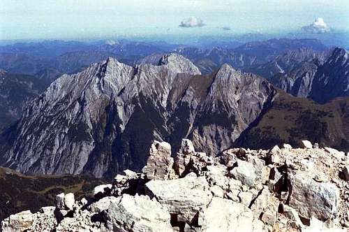
Karwendel like its neighbours Wettersteingebirge and Rofangebirge belongs to the Northern Limestone Alps. Mainly composed – you guessed it – by various forms of limestone the mountain range is notorious for its brittle rock and its huge scree fields. On the upside erosion created one of the most bizarre mountain ranges outside the Dolomites with huge near-vertical north faces, fine pinnacles and towers as well as fine alpine routes. Karwendel is a “difficult” mountain range. Thanks to the brittleness of its rock its climbs are far harder than they appear, even if you look at “objective” grades in guidebooks. A Karwendel UIAA III route might be graded V in other ranges. Also for hikers, the range offers few easy panoramic trails or easily accessible summits. Aside from the Soierngroup and the Karwendel Prealps most summits are hard and difficult to reach. Moreover access routes can be very long often making the summit experience a multi day affair with stopovers at one of the (many) mountain huts. The borders of the range are well defined by the rivers and passes around it.
To the south the range is bounded by the Inn River, to the west by the Isar River and Seefeld Saddle, to the north by the Isar River and to the east by the Achensee Valley. The group itself is made up of four long ridges which all run mainly from west to east. In addition a number of smaller, often horseshoe shaped subgroups are set around it. To the north-east the hill-like Karwendel Prealps fall off against the Isar River. The origin of the name Karwendel is a bit of a mystery. Today it is believed that it stems from an old German family name of the area, Gerwentil. At first the name was only used for the Karwendel Valley and its surrounding summits, a valley which in former times belonged to a family of tat name. On the other hand there is the similarity of the name with that of the eastern Karawanke range, so that the Slavic gor for mountain might also be one of the roots for the name.
Geologic Overview
By wuedesau The Karwendel mountains mainly consist of limestones,dolomites and subordinate sandstones, marls and volcanic material. The sedimentation of these rocks started about 240 million years ago at the beginning of the Triassic period when the huge continent Gondwana broke up (the African continent started to drift to the south) and a large ocean called Tethys formed. This ocean extended from the Pyrenees till South-East Asia. At the beginning Tethys was narrow and the surrounding land was characterized by hot and dry climate. In this time mainly sandstones (Buntsandstein) were deposited that can be found at the base of Karwendel. But soon this ocean got wider forming undersea basins and highs.
Mainly carbonates were deposited from that time on (Alpiner Muschelkalk). Large reefs and lagoons developed. The Wetterstein limestone that builds up large parts of Karwendel is a result of these reefs that grew near the African coast, far from the actual position. Between the reefs and the African continent dolomite was deposited in a very shallow sea. This dolomite today is called Hauptdolomit (main dolomite) which is widespread (especially in the northern part) in the Karwendel. At the end of the Triassic the Tethys Ocean became a deep sea and the reefs disappeared. Clays and radiolarites (composed of radiolarians with a siliceous skeletons were deposited. Due to the high water pressure all imestone that was transported into the deep sea was dissolved. At the end of the Jurassic time, when Tethys almost had the size of the Atlantic ocean, Africa and Eurasia started to converge and the closure of Tethys began.
The up to 10 km thick sediments that covered the ocean floor were folded and later when the process of narrowing proceeded the rigid carbonate platforms were stacked on top of each other. Marine sedimentation still continued during Cretaceous times. The main mountain forming process took place during the Tertiary. The Northern Calcareous Alps including Karwendel were thrusted over the central part of the Alps onto the European continent. Today the reefs that grew in front of the African coast can be found at the northern margin of the Alps. Today the Karwendel mountains are mainly composed of Triassic rocks. Sediments of the Jurassic and Cretaceous times have been been widely eroded and are preserved in synclines only. The actual appearance is a result of tectonic processes (mountain chains and valleys follow synclines and anticlines or tectonic faults) and erosion. During the last ice ages U-shaped valleys and large cirques were eroded. The characteristic rock fans were formed after the last ice age.
Karwendel on SP
 |
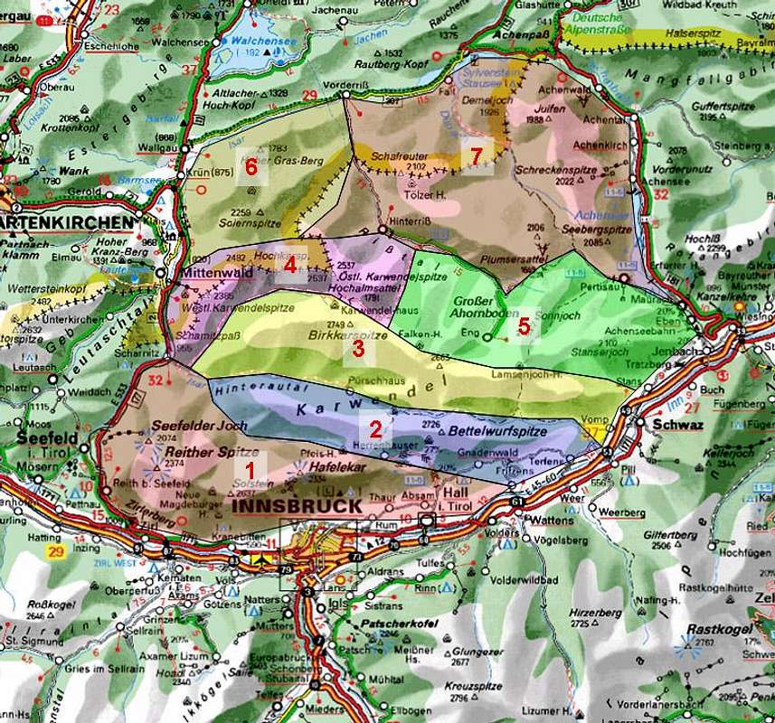
The map above gives an overview over the ranges, the list below shows the already submitted mountains within their respective subgroup.
- Inntal Group
- Lattenspitze
- Gleiersch Halltal Chain
- Karwendel Main Ridge
- Northern Karwendel Chain
- North-Eastern Subgroups
- Soiern Group
- Karwendel Prealps
1 - Inntal Group
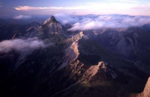
 The Inntal Chain and the eastern Karwendel Ridges seen while paragliding
Composed of two subgroups, the horshoe shaped Erlspitze Group and the Inntalkette (chain) this is the southernmost of the Karwendel subgroups. The mountains tower directly above the city of Innsbruck.
1.1 - Erlspitze Group
- Located to the south-west of Karwendel the Erlspitze Group is formed like a horseshoe which encircles Eppzirl Valley. The highest mountain, Erlspitze, is towering above the valley end with its massive north face. Like everything else in Karwendel this subgroup is made of very brittle rock, in this case main dolomite.
- Seefelder Spitze (2220m)
![]()
- Reither Spitze (2373m)
- Ursprungstürme (2180m)
- Freiungen (2325m, 2322m, 2302m)
![]()
- Kuhljochspitze (2293m)
- Kirchlspitze (2161m)
- Erlspitze (2404m)
![]()
- Fleischbankgrat (2210m)
- Samstagkarspitze (2195m)
- Maderkarlspitze (2173m)
- Zäunlkopf (1749m)
- Hochwaldkopf (1648m)
- Scharnitzer Zunterkopf (1661m)
1.2 - Inntal Chain
The southernmost subgroup of Karwendel is located directly to the north of Innsbruck and towers above the Inn River. It is a single ridge (with the exception of a small lower chain located to the south of the main chain) which runs in west-easterly direction torning slightly northwards in the eastern part. The highest summit of the group is Kleiner Solstein at an elevation of 2637m and located to the west of the chain. In its position above Innsbruck the summits offer great views across the city towards the Ötztal, Stubai and Zillertal Alps on the southern side of the Inn River. The small chain to the south of the main ridge offers some of the best climbing in the area, some of the routes on Martinswand directly accessible from parking lots beneath the south face. - Martinswand (1330m)
- Hechenbergl (1941m)
![]()
- Großer Solstein (2540m)
![]()
- Kleiner Solstein (2637m)
![]()
- Hohe Warte (2596m)
![]()
- Hintere Brandjochspitze (2596m)
- Vordere Brandjochspitze (2558m)
![]()
- Hippenspitze (2362m)
- Frau Hitt (2269m)
- Westliche Sattelspitze (2339m)
- Östliche Sattelspitze (2369m)
- Kemacher (2482m)
![]()
- Kumpfkarspitze (2375m)
- Widdersberg (1958m)
- Kaminspitzen (2445m, 2435m, 2432m, 2379m)
![]()
- Grubeisen Südturm (2255m)
- Grubeisen Nordturm (2260m)
- Seegrubenspitze (2350m)
![]()
- Hafelekarspitze (2334m)
![]()
- Gleierschspitze (2317m)
- Mannlspitze (2364m)
- Gleierschtaler Brandjoch (2372m, 2374m)
- Rumer Spitze (2453m)
![]()
- Thaurer Joch Spitze (2309m)
- Pfeiser Spitzen (2345m)
![]()
- Lattenspitze (2340m)
![]()
- Wildangerspitze (2153m)
- Zunterköpfe (1966m, 1905m)


2 - Gleiersch Halltal Chain
 Gleirsch-Halltal-Chain showing Großer Bettelwurf, Speckkarspitze and Lafatscher as seen from the SE from Hoher Kopf
Located to the north of the Inntal Chain, The Gleiersch Halltal Chain also runs in west-easterly direction and is separated by the Gleierschbach and Halltal Valleys. The chain is divided in two parts by Lafatscher Joch (2085m). The mountains of the chain reach comparable elevations too and Großer Bettelwurf in the eastern end of the chain is its highest summit. In all the chain is 26km long. Like for most ridges of Karwendel the north faces are steep, almost vertical while the southern ones are shallower.
- Hoher Gleiersch (2491m)
![]()
- Äußere Rigelkarspitze (2406m)
- Innere Rigelkarspitze (2437m)
- Katzenkopf (2530m)
- Jägerkarspitzen (2579m, 2604m, 2596m)
- Hinterödkopf (2450m)
- Jägerkarlspitze (2470m)
- Westliche Praxamerkarspitze (2642m)
- Östliche Praxamerkarspitze (2636m)
- Kaskarspitze (2580m)
- Sonntagkarspitze (2575m)
![]()
- Hintere Bachofenspitze (2668m)
![]()
- Rosskopf (2668m)
- Stempeljochspitzen (2543m, 2529m)
- Vordere Bachofenspitze (2663m)
- Großer Lafatscher (2695m)
![]()
- Kleiner Lafatscher (2635m)
![]()
- Speckkarspitze (2621m)
![]()
- Kleiner Bettelwurf (2469m)
![]()
- Großer Bettelwurf (2725m)
![]()
- Fallbachkarspitze (Große Wechselspitze, 2316m)
- Kleine Wechselspitze (2100m)
- Hüttenspitze (1858m)
- Fallbachtürme (2548m)
- Hohe Fürlegg (2570m)
![]()
- Walderkampspitze (2565m)
- Hundskopf (2243m)


3 - Karwendel Main Ridge (Hinterautal Vomper Kette)
 |
The third ridge as counted coming from the south this ist he longest ridge of the whole range. It runs for 40km in west-easterly direction slightly drawing southwards. It is also the only subgroup which consists of more than one single ridge. Multiple side ridges run off to the south and south-west while to the north you’ll only find very short ridges in the western part of the subgroup. Access routes to most of the mountains are very long. The range is home to the source of the Isar River which on its way to its confluence with the Danube runs through Munich. The highest summit of the subgroup as well as of all Karwendel is Birkkarspitze (2749m).
- Pleisenspitze (2567m)
- Boßmannturm (2314m)
- Larchetkarspitze (2541m)
![]()
- Große Riedlkarspitze (2582m)
- Kleine Riedlkarspitze (2244m)
- Breitgrießkarspitze (2588m)
![]()
- Neunerkarkopf (1987m)
- Kleine Seekarspitze (2624m)
- Große Seekarspitze (2679m)
- Speckkarspitze (2621m)
![]()
- Bockkarlspitze (2435m)
- Angerkopf (2232m)
- Spitzhüttenköpfe (2391m, 2499m)
- Marxenkarspitze (2637m)
![]()
- Ödkarspitzen (2711m, 2743m, 2739m)
![]()
- Birkkarspitze (2749m)
![]()
- Hochalmkreuz (2192m)
- Schlauchkarkopf (2502m)
- Hochjöchl (2411m)
- Kaltwasserkarspitze (2733m)
![]()
- Rauhkarlspitze (2619m)
- P. 2526 (2526m)
- Moserkarspitze (2534m)
- Kühkarlspitze (2465m)
- Nördliche Sonnenspitze (2651m)
- Südliche Sonnenspitze (2665m)
![]()
- Bockkarspitze (2591m)
- Ladiztürme (2524m, 2542m)
![]()
- Laliderer Spitze (2583m)
![]()
![]()
- Laliderer Wand (2615m)
- Dreizinkenspitze (2602m)
![]()
- Grubenkarspitze (2661m)
![]()
![]()
- Roßlochspitze (2538m)
![]()
- Hochkanzel (2575m)
- Brandlspitze (2626m)
- Gamskarlspitze (2513m, 2601m)
- Hallenangerspitzen (2442m)
- Sunntigerspitze (2321m)
![]()
- Reps (2159m)
- Plattenspitze (2492m)
- Spritzkarspitze (2605m)
- Eiskarlspitze (2610m)
![]()
- Spitzkarlspitze (2376m)
- Hochglück (2573m)
![]()
- Kaiserkopf (2506m)
- Huderbankspitze (2319m)
- Barthspitze (2454m)
- Schafkarspitze (2505m)
- Mitterspitze (2496m)
- Mitterkarlspitze (2418m)
- Lamsenspitze (2508m)
![]()
- Lamsenhüttenturm (2216m)
- Rotwandlspitze (2321m)
![]()
- Steinkarlspitze (2460m)
![]()
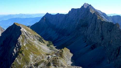
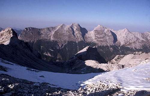
- Hochnissl (2547m)
![]()
- Niedernissltürme (2292m)
- Bärenkopf (1942m)
![]()
- Schneekopf (2313m)
- Mittagspitze (2332m)
- Fiechter Spitze (2299m)
![]()
![]()


4 - Northern Karwendel Chain
 Central part of the Northern Karwendel Chain as seen from Seekarscharte
The northern chain of Karwendel is a 16km long ridge which at firest (in the west) runs from south to north where it bends eastwards. Here – like anywhere in the range – the north faces are steep, almost vertical. The border between Germany in the north and Austria in the south runs along a large part of the ridge. At Östliche Karwendelspitze, the subgroup’s highest mountain at 2537m, it leaves the chain bending northward.
- Brunnsteinspitze (2179m)
- Rotwandlspitze (2193m)
- Kirchlesspitze (2302m)
- Sulzleklammspitze (2323m)
![]()
- Südliche Linderspitze (2306m)
- Mittlere Linderspitze (2339m)
- Nördliche Linderspitze (2372m)
![]()
- Gerberkreuz (2303m)
- Westliche Karwendelspitze (2385m)
![]()
- Karwendelköpfe (2358m, 2365m, 2215m)
- Viererspitze (2053m)
![]()
- Kreuzwand (2312m)
- Drei Kirchln (2241m, 2211m, 2225m)
- Larchetfleckspitzen (2303m, 2363m)
- Tiefkarspitze (2431m)
![]()
- Mitterkarturm (2200m)
- Schönberg (2302m)
- Großkarspitzen (2289m, 2361m, 2426m)
- Hoher Wörner (2476m)
![]()
- Steinkarlkopf (1981m)
- Zunderweidkopf (1720m, 1838m)
- Hochkarspitze (2484m)
- Kampenleitenspitze (1921m)
- Kampenleitenkopf (1689m)
- Hintere Kampenleite (1725m)
- Raffelspitze (2324m)
- Bäralplkopf (2325m)
![]()
- Schlichtenkarspitzen (2354m, 2477m)
![]()
- Vogelkarspitze (2523m)
![]()
- Steinkarlspitze (2030m, 1937m)
- Rappenklammspitze (1835m)
- Hochalplkopf (1771m)
- Ronberg (1755m)
- Vorderskopf (1858m)
- Östliche Karwendelspitze (2537m)
![]()
- Torkopf (2012m)
- Grabenkartürme (2440m)
- Grabenkarspitze (2472m)
- Lackenkarspitze (2413m)
- Karlkopf (2397m)
- Kuhkopf (2390m)
- Talelespitze (2115m)
- Stuhlkopf (2050m, 2016m)


5 - North-Eastern Subgroups
To the north-east of the Karwendel main ridge, somewhat south-east of the northern chain there are a number of smaller subgroups which all are more or less compact and separated by deep valleys. Here they will be grouped together in one subgroup although in literature they are treated separately.
5.1 - Falken Group
 Falken Group seen from Birkkarspitze
- Small and horseshoe shaped this range is located east of Östliche Karwendelspitze and north of Laliderer Spitze. The highest summit is Laliderer Falk at 2427m.
- Mahnkopf (2094m)
- Steinfalk (2347m)
- Risser Falk (2413m)
![]()
- Kleiner Falk (2190m)
- Laliderer Falk (2427m)
- Turmfalk (2200m)
- Totenfalk (2131m)
5.2 - Gamsjoch Group
Rather the group of a sinfle mountain this subgroup culminates in Gamsjoch at 2452m. Three ridges run up towards the summit all of which carry further (lower) summits. To the north there is a small additional circular group around Roßkopfspitze, which is separated from the main bulk.![Gamsjoch group from the ridge...]() The Gamsjochgroup seen from Laliderspitzenbiwak
The Gamsjochgroup seen from Laliderspitzenbiwak - Teufelskopf (1979m)
- Gumpenspitze (2176m)
- Gamsjoch (2452m)
- Ruederkarspitze (2240m)
- Roßkopfspitze (2015m)
- Unterer Rosskopf (1814m)
5.3 - Sonnjoch Ridge
The largest of the north-eastern subgroups is the ridge around Sonnjoch (2457m) – the only one running south to north rather than east to west. It starts at Lamsenjoch and ends in the north near Pertisau. Summits are listed south to north. - Hahnkampl (2080m)
- Bärenwandkopf (1871m)
- Sonnjoch (2457m)
![]()
- Schaufelspitze (2306m)
![]()
- Bettlerkarspitze (2288m)
![]()
- Falzthurnjoch (2150m)
- Feilkopf (1563m)
- Gutenberg (1665m)
5.4 - Rauher Knöll Group
Located to the far east of the north-eastern subgroups the Rauhe Knöll Group is multi ridged. It is a good hiking ground with great views down towards Achensee. Highest summit is Rauher Knöll (2278m) - Schafjöchl (2157m)
- Rauher Knöll (2278m)
- Lunstkopf (2143m)
- Brentenkopf (2024m)
- Rappenspitze (2223m)
- Brunntalkopf (1718m)
- Dristenkopf (2005m)
- Kaserjoch (2198m)
- Gamskarspitze (2098m)
- Hahnenkamp (2086m)
- Ochsenkopf (2148m)
![]()
- Staner Joch (2102m)
![]()


6 – Soiern Group
The group around Soiernspitze (2257m) again is a horseshoe shaped range open to the north. It is located in the north-west of Karwendel. It is lower than the other subgroups and is not as wild looking. Therefore it is a good hiking destination, as any of the summits can be reached by regular folks.
- Schöttelkopf (1902m)
- Schöttelkarspitze (2050m)
![]()
- Seinskopf (1961m)
- Lausberg (1855m)
- Ochsenstaffel (1871m)
- Feldernkreuz (2048m)
- Feldernkopf (2071m)
![]()
- Soiernschneid (2174m)
- Reißende Lahnspitze (2209m)
![]()
- Soiernspitze (2257m)
![]()
- Gumpenkarspitze (2010m)
- Krapfenkarspitze (2110m)
- Dreierspitze (1962m)
- Baierkarspitze (1909m)
- Fermerskopf (1851m)
- Galgenstangenkopf (1806m)
7 - Karwendel Prealps (Pre-Karwendel)
Still belonging to the Karwendel Natural Park to the north of the mountain range you can find an assortments of mountains and hills most of which are covered with forests. The most interesting mountains of the group tower above Achensee in the east.![Demeljoch, Zotenjoch and...]() Overviewing the Karwendel Prealps from Schafreuther
Overviewing the Karwendel Prealps from Schafreuther - Roßkopf (1125m)
- Grammersberg (1471m)
- Pürschschneid (1638m)
- Stuhlbachjoch (1736m)
- Grasköpfl (1753m)
- Grünlahnereck (1726m)
- Schafreuter (2102m)
![]()
![]()
- Kotzen (1766m)
![]()
- Stierjoch (1908m)
![]()
- Luderwände (1903m)
- Torjoch (1818m)
- Lerchkogel (1688m)
- Baumgartenjoch (1939m)
- Rosskopf (1839m)
- Schönalpenjoch (1986m)
![]()
- Fleischbank (2026m)
![]()
- Hölzelstalljoch (2012m)
- Grasbergjoch (2020m)
- Heimjoch (1873m)
- Kompar (2010m)
- Satteljoch (1935m)
- Mondscheinspitze (2106m)
- Mantschen (1825m)
- Seebergspitze (2085m)
![]()
- Seekarspitze (2053m)
![]()
- Zunterspitze (1926m)
- Schreckenspitze (2022m)
- Hochplatte (1815m)
- Marbichler Spitze (1898m)
- Kafell (1906m)
- Rether Kopf (1926m)
- Marlkopf (1776m)
- Juifen (1988m)
![]()
- Demeljoch (1924m)
- Zotenjoch (1881m)
Getting There
Karwendel has been set aside as a natural park already very early. Consequently there are only a few roads which reach into the range. But there is a road quadrangle around the group which will rather easily get you to the main cities, towns and villages, Innsbruck and the villages in Inntal Valley, Pertisau near Achensee and Mittenwald and Seefeld to the east. The nearest airports are Munich and Stuttgart in Germany and Innsbruck in Austria and the following itineraries are given from them respectively.- From the North Mittenwald can be reached most easily from Munich via motorway A95, which end a few km before Garmisch. The following road, dubbed E533 connects Garmisch, Mittenwald and Seefeld. For the eastern part of Karwendel follow A8 from Munich in direction Salzburg and turn off onto B318 southward at Holzkirchen. Follow the road along Tegernsee, after which it changes names to B307 and leads to Achenpass. Here you cross the German / Austrian border and take B181 to Pertisau.
- From the SouthThe Airport Innsbruck Kranebitten is located directly beneath Inntalkette, the southernmost of the Karwendel ridges. For the western part (Seefeld, Mittenwald) take B151 to Zirl where you turn onto B177 which connects Seefeld with Mittenwald. For the eastern part (Pertisau / Achensee) take A12 (toll!) to Strass where you turn northward onto B181.
Red Tape
The whole area of the Karwendel Range has been set aside as a natural park, the Alpenpark Karwendel which even crosses the border between Germany and Austria. It is probably the largest natural park of the northern Alps though it is open for extensive cattle grazing, forestry and hunting as well. A few, mostly obvious rules apply:- Don't pluck flowers or mushrooms, don't take animals out of their habitat
- Stay on marked trails
- Keep dogs on leash
- The Rißtal Valley is closed in certain sections between mid April and mid August to care for a bird species in danger of getting extinct in the area (Common Sandpiper / Actitis hypoleucos)
- Mountainbikes are only allowed on specially marked trails
Mountain Huts and Refuges
Huts
There are a great number of huts, alms and pastures in the range, serving almost any of the spots in the area. The following table gives an overview.Refuge / Hut Height Summer Winter Tel. Thumbnails Nördlinger Hütte 2238m June - beg Oct. closed +43/664/1633861 Eppzirler Alm 1455m mid May - mid Oct closed +43/664/4629211 Solsteinhaus 1805m June - mid Oct. closed +43/5232/81557 Neue Magdeburger Hütte 1637m mid May - mid Oct closed +43/5238/88790 Aspachhütte 1535m weekends closed +43/512/587828 Berghotel Seegrube 1906m all summer all winter? +43/512/293375 Höttinger Alm 1487m May - beg. Nov. +43/676/3056228 Halleranger SV Hütte 1765m all summer all winter +43/5213/5326 Hallerangeralm 1774m beg June - mid Oct. Closed +43/5213/5326 Hallerangerhaus 1768m June - mid Oct. closed +43/5213/5326 Pfeishütte 1922m June - mid Oct closed +43/512/292333 Winklerhütte 1365m beg May - end Oct. closed n.a. Bettelwurfhütte 2079m mid June - mid Oct. closed +43/5223/53353 Pleisenhütte 1757m end May - mid Oct Christmas - Jan 6th +43/664/9158792 Larchetalm 1174m n.a. n.a. +43/663/9759311 Karwendelhaus 1765m June - mid Oct. closed +43/5213/5623 ![]()
Birkkarhütte 2635m all summer all winter n.a. ![]()
Falkenhütte 1846m beg June - mid Oct closed +43/5245/245 ![]()
Lamsenjochhütte 1953m June - mid Oct closed +43/5244/62063 ![]()
Brunnsteinhütte 1560m May - Oct on fine weekends +49/172/8909613 Tiroler Hütte 2153m June - beg. Oct. Closed +43/179/4530056 Mittenwallder Hütte 1515m mid May - end Oct closed +49/172/8558877 Dammkarhütte 1667m mid April - end Sept. closed +49/8823/3826 Hochlandhütte 1624m end May - mid Oct closed +49/174/9897863 Plumsjochhütte 1630m May - end Oct. Closed +43/5243/5487 Gramai Hochleger 1756m beg May - mid Oct closed +49/5243/5166 Bärenbadalm 1457m beg. May - end Sept. closed +43/5338/6768 Weißenbachhütte 1556m n.a. n.a. +43/5243/5539 Soiernhaus 1613m mid May - mid Oct closed +49/171/5465858 Tölzer Hütte 1835m mid May - mid Oct. closed +43/664/1801790 Wirtshaus Bächental 919m n.a. n.a. +43/52/4665631 Rotwandlhütte 1528m Sa/So/holidays Sa/So/holidays n.a. Seewaldhütte 1640m mid July - end Aug. Weekends May - Nov. + 43/664/3537019 Wirtshaus Eng 1218m mid May - mid Oct +43/5245/231 n.a. Bivouacs
As for Bivouacs I know the followingBivouac Height Thumbnails Lalidererspitzen-Biwak 2550m ![]()
Breitgrieskarschartenbiwak 2388m ![]()
Accommodation
Each of the towns and villages of the area has a homepage with the possibility to book hotel rooms and apartments. Follow one of the links below.- Innsbruck
- Pertisau
- Mittenwald
- Seefeld
- Garmisch Partenkirchen
Weather Conditions
Weather links: Webcams:- Mittenwald
- Seefeld
- Garmisch Partenkirchen
Maps & Books
Maps
- Digital Maps
- www.austrianmap.at
- Karwendelgebirge Kompass GPS 4026 Kompass Verlag ISBN: 3-85491-253-6
- Regular Maps
- Karwendelgebirge Kompass Map WK 26 1:50.000 ISBN: 3-85491-027-4
- Alpenvereinskarten of the German Alpine Club
- 5/1 Karwendelgebirge, westl. Blatt, Art.Nr.: 100010
- 5/2 Karwendelgebirge, mittl. Blatt, Art.Nr.: 100011
- 5/3 Karwendelgebirge, östl. Blatt, Art.Nr.: 100012
Books
- Karwendel S. Garnweidner Kompass WF 907 Kompass Verlag ISBN: 3-85491-284-6
- Karwendel Robert Demmel Rother Verlag ISBN 3-7633-4214-1
- Karwendel Walter Klier Alpenvereinsführer Rother Verlag ISBN 3-7633-1121-1
External Links
Fascinating 3D flight simulation through Alpenpark Karwendel


mvs - Jan 21, 2018 1:17 am - Voted 10/10
Stanser JochHowdy! I added the Stanser Joch (http://www.summitpost.org/stanser-joch/1013918), which could be linked to in section 5.4.
Gangolf Haub - Jan 23, 2018 5:57 am - Hasn't voted
Re: Stanser JochHi Michael, looks like the other Michael beat you to it ... http://www.summitpost.org/stanser-joch-ochsenkopf/475006 Cheers Gangolf