
-
 61248 Hits
-
 96.25% Score
-
 58 Votes
|
|
Area/Range |
|---|---|
|
|
42.16000°N / 9.13000°E |
|
|
Hiking, Mountaineering, Trad Climbing, Sport Climbing, Scrambling, Canyoneering, Skiing |
|
|
Spring, Summer, Fall, Winter |
|
|
8878 ft / 2706 m |
|
|
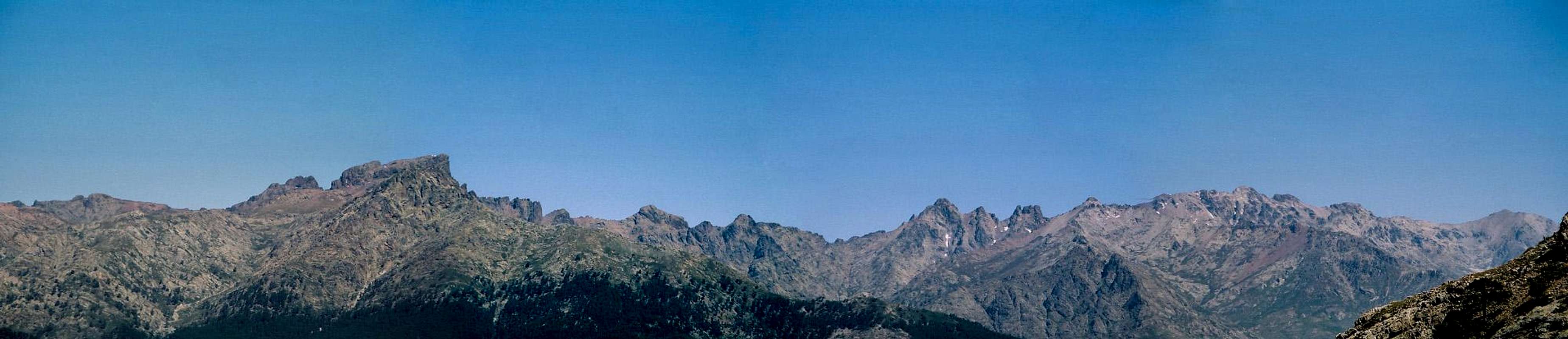
La montagne dans la mer - overview
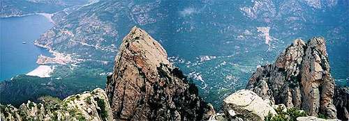 Looking down from Capo d'Orto into the Gulf of Porto Looking down from Capo d'Orto into the Gulf of Porto |
The mountains in the sea, Corsica, also dubbed Ile de la Beauté (island of beauty, is the fourth largest island in the Mediterrenean with an area of about 8700 square km. Only Sicily, Sardinia and Cypros are larger – on the other hand no island offers more mountainous area. Corsica reaches an average (!!) elevation of 570m, 86% of the island can be considered mountains. 50 summits reach more than 2000m in elevation with Monte Cinto being the highest one. The island measures 183km from Cap Corse in the north to Capo Pertusato in the south and 83km from Capo Rosso in the west to Alistro in the east. Thanks to a large number of bays the coastline measures more than 1000km.
While Corsica belongs to France, the distance to the Italian coast is much closer (80km to Livorno vs. 180km to Nice). The Strait of Bonifacio to the south between Corsica and Sardinia is only 12km wide. The Corsican locals are fiercely patriotic and apparently have never been truly happy about their status as just another département of France. 88% of inhabitants consider themselves Corsican first and French later (58%). Corsica has its own language, which is close to the dialects of Tuscany and the dialect which is spoken in the Galura region in the north of Sardinia. The UN considers Corsican as one of the languages in danger of becoming extinct. “The language has several dialects including Northern Corsican, spoken in the Bastia and Corte area, and Southern Corsican, spoken around Sartene and Porto-Vecchio. The dialect of Ajaccio has been described as in transition. The dialects spoken at Calvi and Bonifacio are closer to Genoa dialect, also known as Ligurian.” (from wikipedia.com).
Corsica's patriotism can be found at every street corner - and quite literally so. In the centre of the island you will barely find one street sign in which French names haven't been wiped out to leave only the Corsican ones. Sometimes navigation gets quite irritating as the maps you can buy only show the French names.
The island was created during the Tertiary Age, much like the Alps and it shares a similar history. The foundation is granite, which is omnipresent especially in the nest north and centre of Corsica. The highest mountains are built up of solid granite while on the west and north coasts you find the bizarre Tafoni, hollowed out granite formations which engage the imagination. In the south of the island you find limestone rocks – very similar to the ranges of Sardinia and in the east you find schist and alluvial deposits.
As for hiking and climbing, all areas – except for the flat east – offer numerous possibilities. Naturally the mountains draw most attention. The big ones, Monte Cinto, Monte Rotondo, Monte d’Oro and Monte Renoso are connected by the long Corsican trekking trail GR20, one of Europe’s most difficult trails – which connects the north-west and south-east of the island over 200km and 15 days. There are numerous deep and narrow gorges on Corsica, all of which willed with uncountable numbers of basins and cascades. While most visitors explore only the easily accessible parts there are a number of remote gorges available for canyoneering. Moreover, in some of the narrower gorges, like Restonica Gorge, you find perfect (and popular) climbing walls.
Hiking in Corsica means negotiating the macchia, dense man-sized bushes of rockroses, rosemary, lavender, gorse and heather. While it may look and smell gorgeous the undergrowth is often so dense that you hardly can get through. An hour in the macchia will leave your body bruised, especially if you came in short pants. Moreover, orientation in the bushes is far from easy – even the regular trails get quickly overgrown, luring you in many false starts and ends.
Corsica on SP
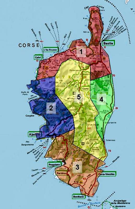  |
Politically today Corsica is divided in two departments: Haute Corse in the north of the island and Corse du Sud in its south. However for the sake of clarity I divided it here in the five regions: the four main regions along the coast and the central mountain range. Currently there are only pages out of the West Coast, East Coast and Haute Corse Regions.
- The North Coast
- The West Coast
- The South
- The East Coast
- Haute Corse
- Monte Pardu
- A Muvrella
- Punta Culaghia
- Punta Stranciacone
- Capu a u Dente
- Dent d'Asco
- Cima a i Mori
- Capu Biancu
- Monte Cinto
- Punta Minuta
- Capu Larghia
- Monte Albanu
- Paglia Orba
- Capu Tafonatu
- Capu a u Tozzu
- Punta Capitellu
- Punta alle Porta
- Le Forcelle
- Monte Rotondo
- Monte d’Oro
- Monte Renoso
- Punta della Cappella
- Punta d'Ortu
- Punta Malanda
- Punta di Caracutu
- Punta di l'Acellu
- Punta di l'Ariettu
- Punta di a Vacca
- Punta Caletta
- Punta di U Chiapponu
- Aiguilles d'Ornucciu
- U Peru
- Orgui d'u San Petru
- Teghie Lisce
- Punta Lunarda
- Punta Rossa
- Punta Tafunata di Paliri
- Punta Paliri
- Punta di u Bracciu
- Punta di Rinaghju
- Punta Velacu
- Gorges de Tavignano
1 - The North Coast
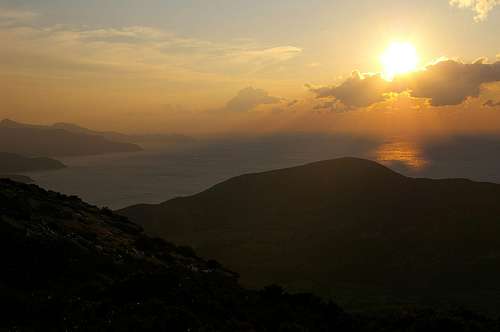 Sunset across the bay of Argentella
The most outstanding part about the north coast is Cap Corse, the peninsula, which stretches north from Bastia and which is a popular hiking ground with popular views. To the south of Bastia along the north-east coast you find the regions of Casinca and Castaniccia, two areas, which are famous for the chestnuts (->name) and the beautifully located villages which overlook the north-and east coast.
The stretch between the northern mountains around Monte Padru and the sea is called the Balagne. There are beautiful mountain villages as well and some of the best known tourist towns and beaches (L'Ile-Rousse, Calvi). To the north-west the area of the red granite starts, complete with all the weathered Tafoni Corsica is famous for (see next section). The coast turns from flat near the beaches to rocky and vertical as one draws nearer to Porto on the west coast.
2 – The West Coast
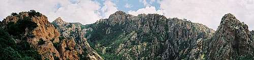 Panorama of Les Calenche. In the center background you can see Capu di u Vitullu.
Apart from the mountains at the centre of the island the west coast certainly is the most mountainous region of Corsica. The mountains rise directly out of the sea to about 1500m. the region between Porto and the capital Ajaccio is only populated near the bays in along the coast with a few small villages in the mountains. The largest towns are Ajaccio, Cargese and Porto.
Porto itself is probably the best point to stay for any exploration of the island. It is very close to the highest mountains, Paglia Orba, Monte Cinto and Monte Rotondo. You have just drive for half an hour until you reach Col de Vergio, Corsica's highest road pass from where a number of interesting hikes and trecks start.
Moreover, Porto (and neighbouring Piana) are home to Corsica's main natural attraction, Les Calenche. This is a rocky area of red granite with bizarre Tafoni structures and with the vertical faces of Capo d'Orto and Capo di u Vitullu. The area is best known for the stretches near the road between Piana and Porto but if you leave the immediate surroundings you are in for a treat: impossible stone structures and beautiful climbing crags.
Near Ajaccio you can find the granite monolith of Rocher Gozzi, rising 400m out of the Gavona Valley. The rock is a popular hiking destination though you have to negotiate dense macchia stretches. Moreover, it is one f the most popular climbing destinations on Corsica.
 |
 |
 |
Tafoni - the typical erosion structures of Corsica and Sardinia
The Calenche is composed of a large variety of strange looking rock formations, all having been formed by ages of erosion. Similar structures can be seen on Sardinia and other places of the world, mostly associated with either granite or sandstone. In Corsica this kind of erosion is called Tafoni, derived from the Corsican word tafonare for "perforate". In most of the cases Tafoni have been hollowed out in a semi circular fashion.
The actual process is a combination of physical and chemical erosion forms. Through capillary forces moisture within the rock is allowed to climb to the surface of the rock. Since the fluids dissolve part or the inner rock structure they can deposit these minerals on the surface which form a very hard but also very thin outside crust. In the course of time the effect weakens (or softens) the inner rock structure while the outside crust gets harder and harder.
Once the crust (mainly iron and manganese oxide) is broken and wind and rain can erode the inner and softer rock, the latter is eaten away rapidly (at least on a geological scale) like the innards of your regular breakfast egg. Since moisture will stay longer and since Evaporation is occurring less on the shadowy northern parts of the rocks the crusts there remain very thin and can get broken much more easily.
The whole Tafoni process takes very long and today's Tafonis have been being created since the last ice ages.
 |
 |
 |
 |
 |
3 - The South
Southern Corsica is the region where in all ages Corsicans have preferred to live. There are a number of nice villages, the hills ar not as harsh as anywhere else on the Island. The two islands share a lot of their prehistoric history. You will find menhirs, stone circles, forts in both Gallura on Sardinia and here in the south of Corsica.
The farther south you get the more the typical Corsican granite makes way for white limestone which forms karst high plateaus very much like the ones on neighbouring Sardinia. Some of the towers and rocks are reminiscent of the ones of the Dolomites which coined the name of the Corsican Dolomites. Where there is still granite to be found you also find bizarre Tafoni structures, much like the ones in the Calenche on the west coast.
4 - The East Coast
There is not much to say about the east coast of Corsica. It’s flat – almost marsh like. However the surrounding mountains – while not very high – offer quite nice views towards the coast and the Italian mainland beyond. Also, the islands of Montechristo (yes that’s where the count’s treasure was hidden), Pianosa and Elba can be seen. The area is popular with the beach tourist crowd.
5 - Haute Corse
 |

Cascade in Magnanello Gorge
Now this is where naturally SP should have its focus: the S-shaped main ridge of Corsica’s mountains with its 50 odd 2000ers, la montagne dans la mer. Almost exlusively made up from grey granite the mountains reach 2706m in Monte Cinto, their highest summit. Thanks to their elevation and their closeness to the sea, the high summits are all swept by fierce winds. None are easy to get to, the summit blocks all require hard scrambling / easy climbing.
Equally important are the many deep gorges, mainly the ones which lead in the direction of Monte Rotondo, Corsica's second highest summit. They carry names like Scala di Santa Regina, Gorges de Tavignano, Gorges de Restonica, Gorges de Magnanello. All are famous for their uncountable numbers of cascades and basins, all are as remote as they can be, located at the centre of the island. All are deep and profound. And one, Restonica Gorge, is paradise for climbers.
The following list shows the most important 2000ers of the island, listed from north to south.
Monte Padru Ridge
The northernmost ridge, which actually is a two ridged horseshoe open to the west.
- Punta Radiche (2010m)
- Capo a Dente (2032m)
- Monte Corona (2143m)
- Cima di la Statoghia (2304m)
- Monte Padru (2393m)
- Capo Selolla (2273m)
Cirque de Bonifatu
A Cirque of lesser mountains to the south-west of Monte Padru, best known for the fact that GR20 runs through here during the first (or last) stages.
- Punta Pittinaghia 1801m)
- Capu di Meta di Filu 1819m)
- Capu Taita (1836m)
- Capu Penne Rosse (1992m)
- Capu di a Muvragia (2001m)
- Punta Missoghiu (2201m)
![]()
- Punta Strancianone (2151m)
![]()
- Punta Culaghia (2034m)
![]()
- A Muvrella (2143m)
![]()
- Capu di a Marcia (2151m)
- Capu a u Carozzu (2139m)
- Punta Mezzognu (2085m)
- Punta Innominata (1985m)
- Punta Ghialla (2085m)
- Capu Ladrancello (2145m)


Monte Cinto Ridge
Long ridge with several short side ridges to the north and south, which ridge runs WSW – ENE.
- Capu Scaffone (2075m)
- Capo Rosso (2043m)
- Capo Tafonatu (2343m)
![]()
- Paglia Orba (2525m)
![]()
- Punta Licciola (2237m)
![]()
- Capo Ucello (2176m)
- Capu Tighiettu (2273m)
- Capu di a Crucetta (2186m)
- L'Altare (2157m)
- Punta Rossa / Pic von Cube (2247m)
- Punta Minuta (2556)
![]()
- Capu Rosso (2498m)
- Capu Larghia (2380m)
![]()
- Capu Falu (2540m)
- Capu a l'Inzecca (2299m)
- Monte Albanu (2018m)
![]()
- Monte Cinto (2706m)
![]()
- Capu Borba (2305m)
- Capu Ciuntrone (2656m)
- Punta Selola (2592m)
- Capo a u Verdatu (2583m)
- Capu Terra Corscia (2109m)
- Capu Biancu (2562m)
![]()
- Capo Razino (2268m)
- Punta Jumentella (1992m)
- Capo di u Dente (1957m)
- Cima a i Mori (2180m)
![]()
- Dent d'Asco (2065m)
![]()


Monte Rotondo Ridge
Ridge running NW – SE and turning east at Monte Rotondo. Several eastern side ridges turn off to the north of Rotondo.
- Monte Tozzo (2007m)
![]()
- Punta Artica (2327m)
- Capo Facciato (2117m)
- Cimatella (2099m)
- Capo a I Sorbi (2267m)
- Capo a u Chiostro (2295m)
- Punta Capitellu (2245m)
![]()
- Punta di Castelli (2180m)
- Punta a le Porte (2313m)
- La Maniccia (2425m)
- Monte Rotondo (2622m)
![]()
- Pietra Niella (2345m)
- Punta Fellicina (2437m)
- Punta Diciotte (2379m)
- Monte Cardo (2453m)
- Punta di Capezzolo (2106m)
- Punta di Pinzi Corbini (2021m)


Monte d’Oro Group
Small Group north of Col de Vizzavona.
- Punta Laccione (1982m)
- Punta Migliarello (2254m)
- Monte d’Oro (2389m)
![]()
- Punta Renosa (2008m)
![]()


Monte Renoso Group
Two ridged group, both ridges running north to south.
- Punta Stronditata (2121m)
- Punta di a Vetta (2255m)
- Monte Niello (2157m)
- Punta Scaldasole (2101m)
![]()
- Punta de Sellola (2112m)
- Punta Bacinello (2247m)
- Monte Renoso (2352m)
![]()
- Punta Capella (2032m)
- Monte Grosso (1895m)
- Monte Giovanni (1950m)
- Punta Coperchiata (1939m)


Cappella Ridge
Long Ridge between Col Verde and Bocca de Cateri. Only few high mountains.
- Punta Bocca dell’Oro (1926m)
- Punta di a Cappella (2042m)
![]()
- Punta di Campolongo (1695m)
- Punta Mozza (1931m)
- Monte Formicola (1981m)

Monte Incudine Group
The southernmost Group of Haute Corse. Complex, but only few high mountains.
- Monte Malo (1849m)
- Punta Tinturaia (2029m)
- Punta Mufrareccia (1893m)
- Monte Incudine (2136m)
- Punta di u Fornello (1930m)
Trekking Trails
La Grande Randonee No 20 (GR20)
For trekkers Corsica is best known for GR20, the “Grande Randonee No 20” which – if you believe the locals – is the most difficult trekking trail in Europe. Its length varies between 180 and 200km, depending on the variants and detours you take. It can be done in 15 stages, all of them between 5 and 7h long. The trail avoids the towns and villages, instead following the main ridge of Corsica’s mountains. The overall elevation gain is more than 10000m as you often climb down into the valleys again to find some sort of accommodation.
In former days there was not a single possibility to get fresh food but today that has changed considerably. Camping is only allowed in official campgrounds or near the bergeries and huts along the way. The trail is well marked – red and white signs – and has become quite crowded. As a hiker in the area you can immediately tell that you have reached a stretch of GR20 – you’ll run into large amounts of backpackers.
The treck starts at Calenzana in the north, crosses near Punta Minuta (2556m) and Paglia Orba (2525m), follows one of the main ridges across Col de Vergio to Monte Rotondo (2622m) and heads across Monte d’Oro to Col de Vizzavona. It traverses east of Monte Renoso (2352m), west of Punta di a Capella (2042m) until it reaches the southernmost 2000er, Monte Incudine (2136m) and heads down the endpoint at Conca.
CHANGE:Stage 3 from Haut Asco to the Tighjettu Refuge through the Cirque de la Solitude, which used to be the crux stage of the whole trek, has been closed following a rockfall in 2015, which killed three and injured seven. An alternative route has been established (marked with yellow marks) which heads up to the Pointe des Éboulis, descends to Lac du Cinto, crosses Bocca Crucetta to head down to the refuge.
- Calenzana - Ortu di u Piobbu6h30 / 1550m
- Ortu di u Piobbu - Carozzu: 7h / 670m
- Carozzu - Ascu Stagnu: 6h / 800m
- Ascu Stagnu - Tighjettu: 8h / 1400m
- Tighjettu - Ciottulu di I Mori: 4h / 600m
- Ciottulu di i Mori - Manganu: 8h / 650m
- Manganu - Petra Piana: 6h30 / 850m
- Petra Piana - L'Onda: 5h / 500m
- L'Onda - Vizzavona: 6h / 700m
- Vizzavona - Capanelle: 5h30 / 900m
- Capanelle - Prati: 6h / 650m
- Prati - Usciolu: 6h / 500m
- Usciolu - Asinau: 8h / 850m
- Asinau - Paliri: 7h / 450m
- Paliri - Conca: 5h / 200m
Alta Strada
The Alta Strada (Haute Route) is to tour skiers what GR20 is to trekkers. It follows roughly the same course and connects Monte Renoso, Monte d’Oro, Monte Rotondo and Monte Cinto. However, its feasibility depends on the weather and the amount of snow on the course. It cannot be done each year.
Mare a Mare Sud
There are several shorter trekking routes, called Mare a Mare, which traverse the island from east to west. The southernmost is a 5 day treck if you account for hiking times between 4 and 6 hours. It can be done all year round.
The stages:
- Porto-Vecchio - Cartalavonu : 5h
- Cartalavonu - Levie : 5h
- Levie - Quenza : 4h
- Quenza - Serra di Scopamena : 4h10
- Serra di Scopamena - St Lucia di Tallano : 5h
- St Lucia di Tallano - Burgo : 6h
Mare e Monti Sud
Like Mare a Mare there are several trekking trails Mare e Monti which connect the sea with the mountains and run around the island at medium height. The southernmost of these trails starts at Porticcio and ends at Burgos. It is a 5 day treck if you are prepared for 5-6h hiking days.
The stages:
- Porticcio - Bisinao : 6h
- Bisinao - Coti-Chiavari : 5h30
- Coti-Chiavari - Porto-Pollo : 4h45
- Porto-Pollo - Olmeto : 5h
- Olmeto - Burgo : 5h30
Mare e Monti
The original Mare e Monti trekking trail runs from Calenzana in the north of Corsica along the west coast to Cargese. It keeps away from the crowded places along the coast (most notably Porto and Piana). It is a ten day treck but can also be done in seven days if some of the stages are thrown in together.
The stages:
- Calenzana - Bonifatu : 5h
- Bonifatu - Tuarelli : 6h
- Tuarelli - Galeria : 5h
- Galeria - Girolata : 6h
- Girolata - Curzu : 6h30
- Curzu - Serriera : 3h30
- Serriera - Ota : 6h30
- Ota - Marignana : 5h
- Marignana - "E Case" Revinda : 6h30
- "E Case" - Cargese : 5h
Mare a Mare Centre
The central traverse of the island starts near Ghisonaccia in the east and ends at Porticcio south of Ajaccio. It can be done in seven stages of 4 – 6 hours.
The stages:
- Ghisonaccia > Serra di Fium'Orbu : 3h
- Serra di Fium'Orbu - Catastaghju : 4h
- Catastaghju - Cozzano : 6h30
- Cozzano - Guitera : 4h30
- Guitera - Quasquara : 4h30
- Quasquara - Col St Georges : 6h
- Col St Georges - Porticcio : 5h30
Mare a Mare Nord
The northern Mare a Mare treck is the longest east – west crossing of Corsica. It can be done in 14 4 – 6h stages but should only be tried from April through November. Some of the passages get over 1500m and in winter these stretches are often covered with deep snow.
The stages:
- Moriani - I Penti : 3h30
- I Penti - Pianellu : 7h30
- Pianellu - Sermanu : 4h50
- Sermanu - Corte : 5h
- Corté - Poggio di Venaco : 3h40
- Poggio di Venaco - Vivario : 7h
- Vivario - refuge de l'Onda : 4h
- Refuge de l'Onda - Pastricciola : 4h
- Pastricciola - Guagno : 3h30
- Guagno - Soccia : 4h30
- Soccia - Letia : 5h
- Letia - Marignana : 4h30
- Marignana - "E Case" Revinda : 6h30
- "E Case" - Cargese : 5h
Sentier de la Transhumance
This is a short form of GR20, a single traverse of the highest range on Corsica. It starts at Calenzana in the north and ends at Corsicia just south of Monte Cinto. The treck can be done in five days with hiking times between 5 and 6 hours.
The stages:
- Calenzana - Bonifatu : 5h
- Bonifatu - Tuarelli : 6h
- Tuarelli - refuge de Puscaghja : 5h30
- Refuge de Puscaghja - Albertacce : 6h
- Albertacce - Corscia : 5h30
Getting There and Accommodation
By Plane
Both Ajaccio and Bastia have airports which, however, are served mostly by local carriers (Air France and Air Corsica). There are some (few) charter lines which fly to both airports from the UK in summer.
By Ferry
There are quite a number of ferry ports on the islands, the most important of which are Ajaccio and Bastia again. While the common route is via Marseille, Nice or Genova the shortest route is via Livorno on Italy’s west coast. The following table gives and overview of ports and destinations
| Port | Origins |
| Bastia | Toulon, Savona, Marseille, Nice, Genova, Livorno |
| L’Ile Rousse | Toulon, Savona, Marseille, Nice, Genova, |
| Calvi | Marseille, Nice |
| Ajaccio | Marseille, Nice, Toulon, Genova, Porto Torres |
| Propriano | Toulon, Marseille, Porto Torres |
| Porto Vecchio | Marseille |
Accommodation
In recent years more and more travel companies cater to Corsica tourists. Consequently you will be able to book hotel rooms and apartments from any travel office in Europe. However, most hotels are to be found on the coast which is far from perfect if you are thinking of climbing the mountains. Camping is restricted to official campgrounds (the policy is enforced!). On GR20 there are a number of huts around which you can camp (fees of around 5€).
Red Tape
In 1971 the Parque Naturel de la Corse was established. It comprises 2500 square km, mainly in the centre of the island. There are no additional restrictions to what common sense would demand.
Weather Conditions
The weather on Corsica is typical for all the Mediterrenean: hot, dry summers and moderate humid winters. Obviously this holds only true literally on the coasts. In the mountains temperatures can be lower by 20°C and almost always the mountaintops are swept by fierce winds (see below). Moreover, there is much more rain in the mountains – up to four times as much as on the coasts. Some of the snowfields on the north faces survive all summer. For online weather information Corsica see the Meteo Corse page.
The Winds
On Corsica all winds have a name – weather turns quite different depending from wherever the wind blows.
- li>North:
Tramontana
- : cold and dry like Föhn south of the Alps
- North-West: Mistral (Maestrale): cold and dry with very crisp, clear air
- North-East: Grecale: humid and warm
- East: Levante: humid and warm, forms the dunes on the east coast
- South-East: Scirocco: humid and hot – brings thunderstoms
- South-West: Libeccio (Libeccu): regular wind direction – often brings rain
- West: Ponente: hot
Maps & Books
Maps
- IGN Institut Géographique National topo map series
1 : 25.000
You need up to 18 maps for the whole of Corsica - Digital IGN Map: tab.geoportail.fr
- Carte routière : Corse du Sud - Haute-Corse
Cates Locales Michelin
1:150000
ISBN : 2061004067 - This map serves as the basis of Michelin’s road maps on the web
Books
There are quite naturally quite a number of guidebooks, most of them in French. I found the following as good as could be expected:
- Corsica (Corse / Korsika)
Klaus Wolfsperger, Tom Krupp
Rother Verlag
ISBN: 3-7633-4819-0 (English)
ISBN: 3-7633-4907-3 (French)
ISBN: 3-7633-4280-X (German) - Topo Guides by the Parc Naturel du Corse
- Trail Guides by the Parc Naturel du Corse
selinunte01 - Dec 28, 2008 5:45 pm - Hasn't voted
Good topo maps availableThis is a very good overview - thank you for that. I would like to add that there are quite good topo maps available for hiking: its the IGN Institut Géographique National 1 : 25.000 topo map series, available for France and Corse. You can buy them at bookshops. To cover the whole island you need about 18 different maps - well - but they are very exact with all hiking trails, roads, paths and so on. 7 maps cover the main hiking regions round Monte Cinto / Monte Rotondo and the west coast. I used them during my 2007 stay and was very satisfied. If there is time I will add two more mountains and some nice pictures from my trips.
Gangolf Haub - Jan 4, 2009 5:05 am - Hasn't voted
Re: Good topo maps availableMerci! Actually I was aware of the maps - I had seen one in a shop in Porto (?). But when I wrote the page I didn't know where to look for them and never found the information. Later I forgot. I'll make the addition...