
-
 22534 Hits
-
 85.36% Score
-
 20 Votes
|
|
Area/Range |
|---|---|
|
|
47.07000°N / 10.15000°E |
|
|
Hiking, Mountaineering, Trad Climbing, Sport Climbing, Ice Climbing, Mixed, Scrambling, Skiing |
|
|
Spring, Summer, Fall, Winter |
|
|
10394 ft / 3168 m |
|
|
1 - Overview
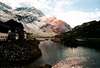
 Ferwall Group as seen across the Leutkirch hut Ferwall Group as seen across the Leutkirch hut |
The Ferwall Group - also often called Verwall (for the name see a couple of lines below) is located at the centre of the Alps. It's neighbours to the north are the northern limestone Alps with Lechquellengebirge and Lechtal Alps, the Samnaun Group and Ötztal Alps to the east, the Silvretta Group to the south and the Rätikon Group to the west. The range is known for the ski resorts to its south, Galtür and Ischgl and for Klostertal to its north. However, in summer you can still find lonesome, solitary and remote places in the group, especially to its northern side. The range forms a triangle positioned on its (southern) tip.
The Range can be easily reached by E60 the motorway/road which connects Bregenz in the west with Innsbruck in the east and one of the most famous high roads of the Alps, Silvretta Hochalpenstrasse, circles it to the south. The group itself is composed of numerous ridges which run in each and every direction, making it quite difficult to subdivide it into subgroups. The Alpenvereinsführer (see Maps and Books section) has proposed a subdivision into 17 subgroups most of which amount to small ridges or solitary standing (equally small) ranges. For SP I have clustered these subgrups together into groups of twos, threes and fours in order to give an easily comprehensible overview.
In general the group is divided into two parts, western and eastern, the subdivision following the border between the two Austrian states of Vorarlberg and Tirol (actually a bit east of it since the border runs along the Fasulkamm Ridge while the subdivision uses the Fasulbach Creek Valley to its east). The most prominent and highest peaks can be found on the eastern side with Hoher Riffler, the highest summit of the range at 3168m, almost at its easternmost tip. To the south-west and west you find the lowest but by no means unimpressive groups as they offer absolutely stunning views towars the Rätikon and Silvretta Groups.
Geologically the group is formed by several kinds of rocks. The westernmost part (Itonskopf Group) is made up from limestone, a reminder that the northern limestone Alps are quite near to its north (and the subgroup is considered part of them). Along the whole northern border of the Ferwall Group you will find Phyllitgneis Rock with a patch of quarzphillite to the north-east near landeck. Most of the rest of the group is composed of paragnesis forms (glimmering schist and amophiolite) with west-to-east running patches of ortogneis (granite-like or apilitic).
As for the name there is quite some confusion, though it only concentrates on the first letter. Verwall vs. Ferwall, and this might well be a distinctin between the Vorarlberg and Tirol dialects. Generally the name is retrieved from the Latin (Italian) word Valbella which seems to have morphed into Verwall during the times of the big vowel shift of rhaetoromanic languages. However, the name is pronounced exactly as if it was written like Ferwall - like many other German words. Here on SP the F-name seems to be preferred - though all guidebooks and maps I know spell the name with a (capital) V.
The Ferwall Group - unlike the northern limestone Alps - is shome to a large number of glaciers. However, all the 37 glaciers (as of 1969!!) are small and some of them have already vanished while others are on the point of vanishing for good. There are eight 3000ers in the range, with Hoher Riffler to the east the highest of all. All of the 3000ers are located in the Riffler-, Kuchenspitz-, Kartell- or Fasulkamm Groups.
2 - The Ferwall Group on SP
|


The Fervall Group is made up of a number of ridges which run in every direction. Generally thhe group is divided in two parts, a western Vorarlberg one and an eastern Tirol one. The border between these two parts runs a bit east of the border between the two Austrian states. In all, 17 subgroups and ridges are identified, which for the sake of clarity I grouped into twos threes and fours to come up with the following six subranges (three western and three eastern ones):
3 - Itonskopf / Hochjoch Ranges
The two subgroups of his subrange are the lowest ones of the whole Ferwall Group. They are located at the westernmost tip of the inverted Ferwall triangle around Itonskopf and Hochjoch. Both groups are separated by the Silbertal Valley and can be easily reached from Schruns.- Davennakopf (1708m)
- Davenna (1881m)
- Zwölferkopf (1843m)
- Monteneu (1883m)
- Wannaköpfle (2032m)
- Itonskopf (2089m)
- Sonntagskopf (2032m)
- Gräntakopf (1796m)
3.2 - Hochjochstock
The Hochstockjoch Area is bounded by Silbertal to the north and west and Montafon to the south. The mountains are easily accessible and offer some of the best (and easiest accessible) views of the whole Ferwall Range. The highest summit of this small group is Hochjoch (2520m)
- Mittagsjoch (2362m)
- Hochjoch (2520m)
- Kapelljoch (2469m)
- Kreuzjoch (2395m)
- Zamangspitze (2387m)
3.1 - Itonskopf Group
This subgroup is considered part of the northern limestone Alps as it is composed of that kind of rock. The north faces along Klostertal Valley are very steep while on the southern sides you fiond relatively easy ascent routes The highest summit of this group, Itonskopf, barely exceeds 2000m. The area around Schruns is the most heavily populated area of the Ferwall Group.
4 - Eisental / Drosberg / Kaltenberg Ranges
This group, consisting of three separated ridges is located in the north of the Ferwall Group. Boundaries are Klostertal to the north, Silbertal to the south and Verwalltal to the east. The mountains of this area are made up from different kinds of gneiss. The northernmost parts are easily accessible while the lower mountains in the southern Drosberg Range are quite remote and lonesome.- Muttjöchle (2074m)
- Mittagstein (2035m)
- Burtschakopf (2244m)
- Omesspitze (2589m)
- Plattingrat (2498m)
- Hochburtschakopf (2662m)
- Westliche Eisentaler Spitze (2710m)
- Gaflunaspitze (2674m)
- Silbertaler Lobspitze (2605m)
- Fellimännle (2209m)
- Östliche Eisentaler Spitze (2753m)
- Reutlinger Turm (2606m)
4.2 - Kaltenberg Group
The Kaltenberg Group is the most important group of the western Ferwall Group in terms of Alpinism. While here, like in the Eisental Group, the northern summit are low and easy, the southern summits around Pflunspitze are difficult and hard to get to. There are numerous routes up the highest summit, Pflunspitze (2912m). The group is separated from the Eisental Group by the Nenxigastbach Creek Valley.
- Pflunspitze (2912m)
- Kaltenberg (2896m)
- Satteinser Spitze (2722m)
- Krachelspitze (2686m)
- Stubener Albonakopf (2654m)
- Maroiköpfe (2522m, 2529m)
- Knödelkopf (2400m)
- Peischelkopf (2412m)
- Wirt (2339m)
- Gstanskopf (2730m)
- Wildebene (2570m)
4.3 - Drosberg Group
The Drosberg Group is a single west-east ridge stretching between the Gafluna and Pflun Valleys in the north and the Silbertal Valley in the south. It is located at the heart of the western Ferwall Group and very lonesome. There are almost no trails in the group and the few summits are difficult to get to. You need alpinistic experience. The highest summit of the Group is Gaflunakopf
- Drosberg (2661m)
- Pfannseekopf (2611m)
- Gaflunakopf (2676m)
- Muttberg (2551m)
4.1 - Eisental Group
This subgroup is located between the Itonskopf Group in the west and the Kaltenberg Group to the east. It can be reached via cable-car and consequently is quite crowded. Apart from easy hiking there are quite a number of climbs out there ranging up to UIAA VII. In winter you can find several ice falls to practise your ice climbing skills. The highest summit of the group is Östliche Eisentaler Spitze (2753m)
5 - Maderkamm / Valschavielkamm / Fluh Ranges
This is the southernmost part of western Ferwall, a group of three ranges, located between the Montafon Valley in the south, Silbertal in the west and north and Zeinisjoch to the east. Like in the northern subgroups the outlying parts (here south) are easy to get to while the central parts are difficult and lonesome. All subranges are worth visiting, even in winter, when the Fluh Range offers good ski touring opportunities.- Scheimersch (2420m)
- Geisterspitze (2480m)
- Roßberg (2381m)
- Dürrkopf (2407m)
- Dreier (2321m)
- Schärmsteeberg (2370m)
- Luterseeberg (2480m)
- Tälispitz (2616m)
- Madererspitze (2769m)
- Zapfkopf (2288m)
- Grappeskopf (2206m)
- Frastafaller Spitz (2571m)
- Giampspitze (2533m)
- Giampkopf (2470m)
- Schwarze Wand (2592m)
- Fanesklaköpfe (2505m, 2539m)
- Valschavieler Plattenspitze (2561m)
- Torkopf (2636m)
- Valschavielkopf (2696m)
- Albonakopf (2482m)
5.2 - Valschavielkamm Ridge
Valschavielkamm also is a single ridge, however running from SW to NE. In the south it is accessible from Silvretta Hochalpenstrasse by chair lift but in the north, where it gets close to the Madererkamm Ridge, it remains quite lonesome. The highest summit of the small ridge is Valschavielberg (2623m).
- Stritkopf (2604m)
- Valschavielberg (2546m, 2623m)
- Verbellakopf (2581m)
- Verbellner Kopf (2488)
- Tafamunter Augustenberg (2489m)
- Versalspitze (2462m)
5.3 - Fluh Group
The Fluhgroup is located at the southernmost tip of the Ferwall Group. The summits are all great lookout spots with views towards the neigbouring Rätikon, Silvretta and Samnaun grous as well as deep into the Ferwall Group itself. They can be reached from Zeinisjoch (and the hotel there) in short ascent times. During winter this subgroup is popular among the ski touring crowd.
- Jöchligrat (2626m)
- Grüner Grat (2741m)
- Schaftäler (2819m)
- Schrottenkegel (2886m)
- Fluhspitze (2512m, 2653m, 2641m)
- Fluh (2473m)
- Fädnerspitze (2788m)
![]()
- Grieskopf (2754m)
- Grieskogel (2641m)
- Gaisspitze (2779m)
5.1 - Madererkamm Ridge
Madererkamm is one of the longest ridges in the Ferwall Group. It runs in east-westerly direction and used to be quite unknown and lonesome. However, after Wormser Weg (see trekking routes section) had been established the summits became more easily accessible. Still, the ridge is remote and you need quite a lot of trekking experience (and stamina) to traverse it. The highest summit is Madererspitze (2760m).
6 - Fasulkamm / Karkopf / Kuchenspitz / Faselfad Ranges
 Saumspitze (3039m), Kuechlspitze (3147m) and Kuchenspitze (3148m) (from left to right)
This is the westernmost of the eastern Ferwall groups stretching all the way from Stoanzertal Valley in the north to upper Paznauntal Valley in the south. There are quite a number of different ridges, which is why this area is subdivided in four subgroups. Some of the most impressive mountains (like Patteriol) are located in this group and Konstanzer Hütte serves as the base for most of the climbs. In fact the hut is the central hub at the center of the whole Fewall Group. All four subgroups are located on Tirol grounds, being located east of the Ferwall Valley.
- Kleiner Patteriol (2590m)
- Patterioltürme (2695m)
- Patteriol (3056m)
![]()
![]()
- Wannenkopf (2766m)
- Rosannagrat (2680m)
- Fasulspitzen (2835m)
![]()
- Talliger (2845m)
- Mitterspitze (2870m)
- Schönverwallkopf (2742m)
- Vollandspitze (2928m)
- Fasulzwillinge (2880m)
- Brüllerköpfe (2882m)
- Vertinesberg (2855m)
- Glatter Berg (2866m)
- Vertineskopf (2685m)
- Hohe Köpfe (2608m)
- Vertinespleiskopf (2706m)
6.2 - Karkopf Group
The Karkopf Group connects the Fasulkamm Ridge to the west with the Kuchenspitze Group to the east. It is located high above Paznaun Valley an can be reached from the Silvretta Hochalpenstraße. Two trails run through the group, Georg Prasser Weg and Ludwig Dürr Weg. The highest summit is Karkopf (2948m)
- Grauer Kopf (2793m)
- Grafspitze (2872m)
- Matnalköpfe (2871m, 2892m, 2897m)
- Karkopf (2948m)
- Madleinkopf (2907m)
- Südlicher Schönpleiskopf (2920m)
6.3 - Kuchenspitze Group
The Kuchenspitze Group is the Alpinistic centre of the eastern Ferwall Group. Difficult to get to, summits above 3000m and several interesting climbing routes make it quite popular among eastern Alps alpinists. The traverse between its highest summits, Kuchenspitze and Küchlspitze, is one of the most impressive climbs in the whole Ferwall Group. Darmstädter Hütte to the east of the group serves as base for most climbs while Konstanzer Hütte to the east offers an alternative base.
- Fasulwand (2885m)
- Kuchenspitze (3148m)
![]()
- Küchlspitze (3147m)
![]()
- P. 2778 (2778m)
- Nördlicher Schönpleiskopf (2943m)
- Rauteköpfe (2849m, 2826m)
- Rautetürme (2825m, 2830m)
6.4 - Faselfad Group
The Faselfad Group is the northernmost subgroup of this range, located between the Ferwall Valley in the west and the Moostal Valley to the east. Summits don't quite reach 3000m but all are out of bounds for the regular hiker. Around the two Faselfadspitzen there are a number of worthwhile technical climbs. Highest summit of this group is Westliche Faselfadspitze.
- Sattelkopf (1985m)
- Kleine Sulzspitze (2741m)
- Große Sulzspitze (2853m)
- Augustenbergkopf (2881m)
- Westliche Faselfadspitze (2993m)
- Östliche Faselfadspitze (2950m)
- Scheibler (2978m)
- Fasulalpkopf (2788m)
- Hahnentrittkopf (2636m)
6.1 - Fasulkamm Ridge
While the western Ferwall groups only reach elevations below 3000m this is the first (westernmost) subgroup which exceeds the magic limit. Fasulkamm is a ridge running from North to south between the Rosanna and Fasulbach Valleys. The highest and most impressive mountains can be found in the north of the ridge while the largest glacier of Ferwall can be found at its south. Both Bruckmannweg and Georg Prasser Weg run through the group which gives the summits at least some accessibility. The highest summit is Patteriol (3056m).


7 - Kartell / Seßlad / Rendl Ranges
 Part of the Kartell and Seßlad ranges seen from Kieler Weg
From Kuchenspitze an long stretched ridge leads north-eastward in the direction of Hoher Riffler in the far east of the Ferwall Group. This ridge, which runs along the north of the Paznaun Valley is divided into several parts by pronounced cols and passes. Generally three subgroups are distinguished, the Kartell, Seßlad and Rendl Groups. Like everywhere in Ferwall, the summits are hard to get to but there are a number of hiking trails crossing the passes from north to south.
- Seeköpfe (3061m)
- Mittelsgrind (2723m)
- Saumspitze (3039m)
- Kartellkopf (2642m)
- Fatlarspitze (2986m)
![]()
- Schnitzer (2973m)
- Fatlarzähne (2863m)
- Älschnerspitze (2837m)
- Oberplattkopf (2789m)
- Burgner (2504m)
7.2 - Seßlad Group
Further east, between Rugglescharte Pass and Lattejoch pass you find the Seßlad Group. The long ridge turns north near Kreuzjochspitze to turn into the Rendl Group. The highest summit is Madnaunspitze (2961m)
- Rugglekopf (2864m)
- Rugglespitze (2809m)
- Breiter Kopf (2532m)
- Kappler Kopf (2404m)
- Seßladspitze (2906m)
- Madaunspitze (2961m)
- Kreuzjochspitze (2919m)
- Riffelspitze (2935m)
- Seespitze (2815m)
- Rote Wand (2810m)
- Karleskopf (2764m)
- Karlestürme (2720m, 2680m, 2670m)
![]()
- Schrofenkopf (2653m)
- Beilstein (2749m)
- Stertaspitze (2735m)
![]()
- Alblitköpfe (2650m)
![]()
7.3 - Rendl Group
![Eastern Rendl Group]() Eastern part of the Rendl Group
Eastern part of the Rendl Group
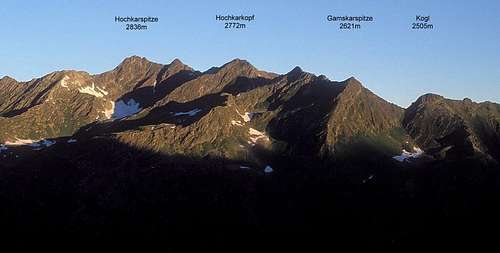
The Rendl Group, though very close to Arlberg Pass, is rarely visited. It offers a small number of hiking summits, which all offer good views towards the Lechtal Alps, the Samnaun Group and into the Ferwall Group itself. In winter the area is popular for ski tours. The highest summit is Hochkarspitze.
- Vordere Rendlspitze (2816m)
- Hintere Rendlspitze (2741m)
- Hochkarspitze (2836m)
- Zwölferkopf (2558m)
- Hochkarkopf (2772m)
- Gamskarspitze (2621m)
- Kogl (2505m)
7.1 - Kartell Group
The Kartell Group is located between Doppelseescharte Pass in the west and the Rugglescharte Pass in the east. It contains two 3000ers and with a bit of alpinistic experience you can traverse the Group using the Hoppe Seyler Weg between Darmstädter Hütte and Niederelbe Hütte. The highest summits are Seeköpfe (3061) in the west of the group.


8 - Welskogel / Riffler Ranges
Like the Itonskopf / Hochjoch Range the Welskogel / Riffler Range is located at one of the tips (the eastern one) of the Ferwall Group. But this is just as much likeness as you will find since the Riffler Group contains the highest summit of Ferwall, while the Itonskopf Group is considered the lowest group of all. The two groups are located between the Rosanna and Trisanna Creeks and quite naturally offer good views towards the surrounding mountain ranges.- Hohe Spitze (2796m)
- Welskogel (2878m)
- Weißer Schrofen (2849m)
- Kappler Jochspitze (2843m)
- Rifflakopf (2680m)
- Weißkogel (2505m)
8.2 - Riffler Group
The easternmost tip of all Ferwall contains its highest summit, Hoher Riffler (3168m). Apart from that mountain there is another 3000er and two 2990er, making the group the highest in the whole Range. Hoher Riffler is one of the few Ferwall summits which can be reached without alpinistic or climbing experience as a hiking trail leads to its summit. Still, the altitude difference of up to 2000m makes it a dificult destination.
- Hoher Riffler (3168m)
![]()
- Blankahorn (3129m)
![]()
- Kleiner Riffler (3014m)
- Mittagspitze (2635m)
- Gauderkopf (2991m)
- Flirscher Fernerkopf (2995m)
- Gampernunspitze (2887m)
- Kapfkopf (2708m)
- Großgfallkopf (2639m)
- Pezinerspitze (2550m)
- Kleingfallkopf (2440m)
8.1 - Welskogel Group
The Welskogel Group connects the Seßlad Group in the west with the Riffler Group in the east. It is a single ridge located between Lattejoch Pass in the west and Kappler Joch Pass in the east. The highest summit of the Group is Welskogel (2878m), which mysteriously enough is missing from most maps of the area (look at www.austrianmap.at for instance).


9 - Trekking Trails / High Routes
The Ferwall Group, thanks to its small size, only offers a small numbers of high routes - quite ulike the Ötztal or Stubai Alps for instance. Also, there are only two handfulls of mountain huts, which, however, are interconnected by a number of hiking trails. These trails can be combined into a multiday treck which leads from Wormser Hütte in the east to Edmund Graf Hütte in the east.Two of the interalpine trekking trails lead through the range, the Hochalpiner Zentralalpenweg (high cantraal alpine trail) and its "ice free variant". Between the huts you can find the following high (sometimes low) routes
| Name | From | To |
| Wormser Weg | Wormser Hütte | HHeilbronner Hütte |
| Emil Roth Weg | Reutlinger Hütte | Heilbronner Hütte |
| Bruckmannweg | Heilbronner Hütte | Konstanzer Hütte |
| Friedrichshafener Weg | Heilbronner Hütte | Friedrichshafener Hütte |
| Ludwig Dürr Weg | Friedrichshafener Hütte | Darmstädter Hütte |
| Sepp Jöchler Weg | Darmstädter Hütte | Niederelbehütte |
| Hoppe Seyler Weg | Darmstädter Hütte | Niederelbehütte |
| Kieler Weg | Niederelbehütte | Edmund Graf Hütte |
10 - Getting There
Access to the group is a not difficult but rather remote. While the north of the group can be reached easily from either side (motorway E60) the southern part can only be reached by the Silvretta Hochalpenstraße (B188). The following itineraries are from the closest international airports at Innsbruck and Stuttgart.- From Innsbruck
Simply take motorway A12/E60 west. At Landeck decide whether you want to stay on E60 for the northern part of Ferwall or head south-west onto B188 direction Ischgl. The latter road circumvents the group and recombines with E60 near Bludenz.
- From Stuttgart
Take Motorway A8 east until you reach Ulm. There turn onto A7 south. At Memmingen leave A7 for A96, direction Bregenz. In Austria the motorway is called A14 and leads to Bludenz, from where you either go along to St Anton and Landeck or take the south-eastern loop around the Ferwall Group via B188 (direction Schruns, Ischgl).
11 - Red Tape
As far as I can tell there are no natural parks or preserves in the region. However, the usual rules apply: no collecting of plants or animals, closing of gates, etc...12 - Mountain Huts & Refuges
12.1 - Huts
The huts are not as numerous as in other groups in the eastern Alps but you have to take into account that the Ferwall group is rather small. As said in the section about trekking and hiking routes you can always reach the next hut in a matter of several hours. Kieler Wetterhütte is rather a bivouac cabin than a mountain hut, but it can be booked via the phone number of the Niederelbehütte. Therefore it is listed together with the other huts.
| Refuge / Hut | Height | Summer | Winter | Tel. | Thumbnails |
| Kristbergsattelhaus | 1443m | all summer | all winter | +43/5556/2290 | |
| Neue Reutlinger Hütte | 2395m | all summer | all winter | +49/7121/330940 | |
| Kaltenberghütte | 2089m | end June – ens Sept. | closed | +43/5582/790 | |
| Wormsser Hütte | 2305 | mid June – mid Oct | Chistmas – Easter | +43/664/1320325 | |
| Neue Heilbronner Hütte | 2308m | mid June – end Sept. | closed | +43/5446/2954 |  |
| Konstanzer Hütte | 1688m | end June – beg Oct. | closed | +43/664/5124787 |  |
| Friedrichshafener Hütte | 2138m | mid June – end Sept. | closed | +43/664/3806765 | |
| Darmstädter Hütte | 2384m | July – mid Sept. | closed | +43/5446/3130 |  |
| Niederelbehütte | 2310m | beg. June – end Sept. | closed | +43/676/841385200 |  |
| Kieler Wetterhütte | 2800m | self service | self service | +43/676/3755144 | |
| Edmund Graf Hütte | 2375m | end June – end Sept. | closed | +43/5448/8555 |  |
12.1 - Bivouacs
Apart from Kieler Wetterhütte there is only one bivouac cabin:
| Bivouac | Height | Thumbnails |
| Roßberghütte | 2200m |
13 - Accommodation
Each of the towns and villages of the area has a homepage with the possibility to book hotel rooms and apartments. Follow one of the links below.- St. Anton
- Galtür
- Ischgl
- Kappl
- Pians
13.2 - Vorarlberg
- Bludenz
- Klösterle
- Stuben
- Schruns
- Silbertal
- St. Gallenkirch
- Gaschurn
13.1 - Tirol
14 - Weather Conditions
In addition to the weather information on the sites you find under accommodation you can look up these sites:15 - Maps & Books
15.1 - Maps
- Digital Maps
- Silvretta-Verwallgruppe
Kompass Digital Map GPS4041
ISBN: 3-85491-276-5
- www.austrianmap.at
- Silvretta-Verwallgruppe
- Regular Maps
- Arlberg-Nördl. Verwallgruppe
Kompass Map WK 33
1:50.000
ISBN: 3-85491-037-1
- Silvretta-Verwallgruppe
Kompass Map WK 41
1:50.000
ISBN: 3-85491-047-9
- Alpenvereinskarte of the German Alpine Club
- 28/2 Verwallgruppe, mittl. Blatt, Art.Nr.: 100027
- Arlberg-Nördl. Verwallgruppe
15.2 - Books
- Arlberg – Paznaun
Herbert Mayr
Rother Verlag
ISBN: 3-7633-4121-8
- Verwallgruppe
Peter Pindur, Roland Luzian, Andreas Weiskopf
Alpenvereinsführer
Rother Verlag
ISBN 3-7633-1251-X