
-
 29510 Hits
-
 82.08% Score
-
 15 Votes
|
|
Area/Range |
|---|---|
|
|
47.03211°N / 113.94016°W |
|
|
Hiking, Mountaineering, Bouldering, Scrambling, Skiing |
|
|
Spring, Summer, Fall, Winter |
|
|
Overview

The Rattlesnake from Missoula
"From its easy-to-get to valley floor to its remote subalpine lakes, the Rattlesnake National Recreation Area and Wilderness provides outdoor activities year-round."
The Rattlesnake National Recreation Area and Wilderness (RNRAW) are in Missoula, Montana's back yard. The Rattlesnake is the closest Wilderness Area to a major metropolitan area (2nd if you consider a tiny designated "wilderness" area in the midwest).
From the Missoula valley, the Rattlesnake looks pretty tame. It is only until one ventures into the high country that one can get a good idea of what this area entails - endless opportunities for hiking, biking, fishing, backpacking, skiing, are more. More than 73 miles of trails cover the area, comprised of 61,000 acres, nearly 33,000 of which are designated Wilderness.
Many of the 30+ high mountain lakes are stocked with fish, and the area contains an excellent sampling of the state's wildlife, including black bears, wolverines, mountain lions, mountain goats, big horn sheep, deer, elk, coyotes and marmots. Hawks, eagles, and osprey soar the skies.
The slopes are carpeted with sub-alpine fir, lodgepole pine, and spruce sloping down to open Douglas fir and ponderosa pine parklands.
Eight trailheads are available to non-tribal members. The northern border of the Wilderness connects to the South Fork Jocko Tribal Primitive Area, which is open only to Flathead Indian Reservation (Confederated Salish and Kootenai tribes) members. Please be aware that a tribal recreation permit is required for hiking, camping, and other activities on the reservation.
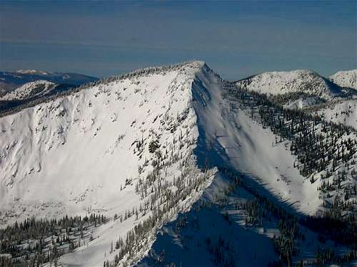
![Stuart Peak]() Stuart Peak
In 1980, Congress set aside 61,000 acres in the Rattlesnake drainage to foster watershed, recreation, wildlife, and education. 28,000 acres were designated a National Recreation Area; the remaining 32,976 acres were designated wilderness.
Stuart Peak
In 1980, Congress set aside 61,000 acres in the Rattlesnake drainage to foster watershed, recreation, wildlife, and education. 28,000 acres were designated a National Recreation Area; the remaining 32,976 acres were designated wilderness.
The highest peak in the Rattlesnake is McLeod Peak at 8,620 feet above sea level and carries 3,000 feet of clean prominence.
Some of the areas named, high peaks include:
Murphy Peak, 8167'
Mosquito Peak, 8057'
Stuart Peak, 7960'
Point Six, 7920'
Triangle Peak, 7800'
Sheep Mountain, 7650' (1995 FS map)
Mineral Peak, 7444' (1995 FS map)
Boulder Point, 7280'
From the Missoula valley, the Rattlesnake looks pretty tame. It is only until one ventures into the high country that one can get a good idea of what this area entails - endless opportunities for hiking, biking, fishing, backpacking, skiing, are more. More than 73 miles of trails cover the area, comprised of 61,000 acres, nearly 33,000 of which are designated Wilderness.
Many of the 30+ high mountain lakes are stocked with fish, and the area contains an excellent sampling of the state's wildlife, including black bears, wolverines, mountain lions, mountain goats, big horn sheep, deer, elk, coyotes and marmots. Hawks, eagles, and osprey soar the skies.
The slopes are carpeted with sub-alpine fir, lodgepole pine, and spruce sloping down to open Douglas fir and ponderosa pine parklands.
Eight trailheads are available to non-tribal members. The northern border of the Wilderness connects to the South Fork Jocko Tribal Primitive Area, which is open only to Flathead Indian Reservation (Confederated Salish and Kootenai tribes) members. Please be aware that a tribal recreation permit is required for hiking, camping, and other activities on the reservation.
 Stuart Peak
The highest peak in the Rattlesnake is McLeod Peak at 8,620 feet above sea level and carries 3,000 feet of clean prominence.
Some of the areas named, high peaks include:
Murphy Peak, 8167'
Mosquito Peak, 8057'
Stuart Peak, 7960'
Point Six, 7920'
Triangle Peak, 7800'
Sheep Mountain, 7650' (1995 FS map)
Mineral Peak, 7444' (1995 FS map)
Boulder Point, 7280'
Wisherd Ridge, ~7000
Blue Point, 6809'
Lockwood Point, 6673
Woody Mountain, 6213'
Trailheads, Access
Most access the Rattlesnake from Missoula, as city streets lead all the way to the closest trailhead. Eight official trailheads are available to the public, and other access point are available. (This is a live work in progress!)Rattlesnake Main Trail #515
Facilities: Restrooms, Disabled Access, Wildlife Viewing Area, No drinking water available. Part of the South Zone, this area is closed from 10 pm to 6 am.
Usage: Heavy
Overview: Close to Missoula, this trail is popular for day hiking, backpacking, and mountain biking. The trail was an old logging road so it is wide, has a relatively gentle grade for the first 9 miles, and roughly parallels Rattlesnake Creek. From the main trail, there are many side trails available. The main trail winds through open ground, dry forested areas, and progresses into western larch and Engelmann spruce farther up the drainage. Beaver dams can often be seen in Rattlesnake Creek about 5 miles up from trailhead. This trail connects to many other trails such as the "Wallman Trail" and could be made into loops.
Directions: From Interstate 90 in Missoula, take the Van Buren Street exit #105 and head north. Van Buren Street will turn into Rattlesnake Drive. Stay on Rattlesnake Drive for approximately 3 miles until you reach the Rattlesnake National Recreation Area entrance. Travel another 0.25 mile and turn left on Sawmill Gulch Road. The trailhead will be on the right after about 0.25 mile.
Notes: Garbage receptacles and parking are available at the Rattlesnake main trailhead. Most popular mountain biking and trail running trailhead. Closed 10 pm to 6 am.
Rattlesnake Horse - horses only, very close to Rattlesnake main.
Facilities: Restrooms, Disabled Access, Unloading Ramp, no drinking water available
Rattlesnake Horse - horses only, very close to Rattlesnake main.
Facilities: Restrooms, Disabled Access, Unloading Ramp, no drinking water available
Usage:
Overview: This trailhead is on the east side of Rattlesnake Creek and provides adequate parking for horse trailers. The trail leads north for about 0.25 mile and then joins up with the main Rattlesnake Trail.
Directions: From Interstate 90 in Missoula, take the Van Buren Street exit #105 and head north. Van Buren Street will turn into Rattlesnake Drive. Stay on Rattlesnake Drive for approximately 3 miles until you reach the Rattlesnake National Recreation Area entrance. Travel another 0.25 mile and turn left on Sawmill Gulch Road. The trailhead will be on the right after about 0.25 mile.
Woods Gulch - Trail #513
Facilities: None
Woods Gulch - Trail #513
Facilities: None
Usage: Light
Overview: This challenging trail is popular for day hiking and mountain biking. It is often used as a main trail for accessing other trails in the area and travels through forested areas. This trail accesses Sheep Mountain which stands at 7582 feet. The grade is fairly steep, increasing 5 miles from the trailhead; the entire trail is challenging overall.
Directions: From Interstate 90 in Missoula, take the Van Buren Street exit #105 and head north. Van Buren Street will turn into Rattlesnake Drive. Stay on Rattlesnake Drive for approximately 3 miles until you reach the Rattlesnake National Recreation Area entrance. Travel another 0.25 mile and turn right on Woods Gulch Road. Follow the road and you will come to a trailhead at the first major bend in the road. Very limited parking.
Sawmill - Trail #24
Facilities: Wildlife Viewing Area
Sawmill - Trail #24
Facilities: Wildlife Viewing Area
Usage: Heavy
Overview: This trail begins on the edge of the meadow and progresses uphill and into ponderosa pine forests. It is steeper than the main Rattlesnake trail and provides good access to other trails in the area - many of which can be combined to make loop routes.
Directions: From Interstate 90 in Missoula, take the Van Buren Street exit #105 and head north. Van Buren Street will turn into Rattlesnake Drive. Stay on Rattlesnake Drive for approximately 3 miles until you reach the Rattlesnake National Recreation Area entrance. Travel another 0.25 mile and turn left on Sawmill Gulch Road. The trailhead is at the end of the road.
Sheep Mountain - Trails #505, 513
Facilities: None
Sheep Mountain - Trails #505, 513
Facilities: None
Directions: From Gold Creek Road #126 on Highway 200, take the first left turn (unmarked as of May 2015) on 2117, following it, rough in places, to the end. At mile xx, a sign at a sharp switchback (and parking for Wisherd Ridge) demarcates the change to FS Road 2119.
The 2011 Delorme, the 1985 Rattlesnake Wilderness map, and the 2001 Lolo National Forest map all incorrectly locate the roads leading to this trailhead. Many sources incorrectly show road 2117 continuing as Twin Creek Road, a gate at the switchback on the border of Sections 27 and 28 indicates a year-long closure for vehicles (but not for snow machines).
Gold Creek - Trail #518, access to Gold Creek Meadows, Fly Lake trail #336
Facilities: None
West Fork Gold Creek - Boulder Lake Trail #333 and trail #52, access to Boulder Point, Boulder Lake, upper corridor above Franklin Bridge
Facilities: None
Gold Creek - Trail #518, access to Gold Creek Meadows, Fly Lake trail #336
Facilities: None
West Fork Gold Creek - Boulder Lake Trail #333 and trail #52, access to Boulder Point, Boulder Lake, upper corridor above Franklin Bridge
Facilities: None
Usage: Light
Overview: This trail winds through a variety of environments including an area burned from a wildfire 2003, forested areas, a creek, open ground, and alpine forest. The trail leads up to Boulder Point at 7100 feet which overlooks Boulder Lake.
Directions: East of Missoula, from U.S. Highway 200, take the Gold Creek Road #126 north. Take Forest Service (FS) Road #2103, then travel to the end of FS Rd # 4323 to the trailhead. The trailhead serves as a jumping off point for both the Boulder Lake Trail and West Fork Gold Creek Trail. Boulder Lake is 5.3 miles from the trailhead. West slope cutthroat trout can be landed at Boulder Lake.
Ravine Creek (via Grant Creek) - Trail #34, access to Stuart Peak
Facilities: None
Ravine Creek (via Grant Creek) - Trail #34, access to Stuart Peak
Facilities: None
Usage: Light
Overview: This trail is the quickest way to Stuart Peak. The trail is forested and switchbacks lead up a steep grade and then ties into the Rattlesnake National Recreation Area trail system.
Directions: From Interstate 90 in Missoula, take exit #101 and head north on Grant Creek Road for about 5 miles. About 1 mile past the turn for Snowbowl Ski Area, you will see hiking signs for the trailhead. Just past the first sign on the right is a small parking area. This is Ravine Gulch trailhead.
Other access points:
Snowbowl Ski area - access to Point Six, Murphy Peak and beyond.
Finley Creek - access to McLeod, northern Rattlesnake
Marshall Canyon - Road 2122 - access to Blue Point
Park at gate on Marshall Canyon road and follow road to Woods Gulch trail.
Flathead Reservation
The South Zone
Other access points:
Snowbowl Ski area - access to Point Six, Murphy Peak and beyond.
Finley Creek - access to McLeod, northern Rattlesnake
Marshall Canyon - Road 2122 - access to Blue Point
Park at gate on Marshall Canyon road and follow road to Woods Gulch trail.
Flathead Reservation
Activities - Camping, Bicycling, Hiking, Hunting, Fishing, etc
The South Zone
The area within three miles of the main trailhead is referred to as the SOUTH ZONE. It includes the main trailhead, the horse trailhead, Sawmill, Woods, Spring and Curry Gulches, and the area south of Curry Trail to Kench Meadow, over to Poe Meadow, and southeast to the recreation area boundary.
There is no camping, fires, discharging firearms, or fireworks within the South Zone.
There is no camping, fires, discharging firearms, or fireworks within the South Zone.
Dogs
Dogs are allowed to be off-leash beyond 1.7 miles in the main Rattlesnake Creek drainage, and after 1.3 miles in Spring Gulch.
To protect Missoula's water, forest wildlife and to reduce conflict, the following restrictions are in place:
Dogs are allowed to be off-leash beyond 1.7 miles in the main Rattlesnake Creek drainage, and after 1.3 miles in Spring Gulch.
To protect Missoula's water, forest wildlife and to reduce conflict, the following restrictions are in place:
Dogs are prohibited from December 1st through the end of February in the Rattlesnake drainage, through May 15 in Spring Gulch, and yearlong in Sawmill and Curry gulches.
Dogs are permitted year-round in Woods Gulch unleashed. Assumption is made by the author that dogs are allowed off-leash at the Gold Creek, West Gold Creek, and Sheep Mountain trailheads as well.
Mountain bikes are only allowed on roads and system trails that are marked with gray diamonds to reduce conflict and for resource protection. Off-trail bicycling, construction of jumps and/or other structures and user-built trails are prohibited. Mountain biking can be done on the main Rattlesnake Trail #515, Ravine Creek Trail #34, Sawmill Trail #24, and Woods Gulch Trail #513.
For everyone's safety, use moderate speeds, slow down when approaching other rides, and speak - especially to horseback riders - when approaching from the rear. the lower 0.6 miles of the main Rattlesnake trail has a 10 mph speed limit.
Camping
There is no camping allowed within the South Zone, which includes the main trailhead, the horse trailhead, and the Sawmill and Woods Gulch trailheads. Fires are also not permitted within the South Zone.
Wildlife food/attractant storage order in effect,April 1– Dec. 1; suspend food/attractants 10 feetoff the ground and 4 feet from an uprightsupport, or in a hard sided vehicle or camper, orin an approved bear resistant container. Must bedone when unattended and at night.
Fishing
Fishing in the Rattlesnake Creek is allowed above Beeskove Creek, about six miles from the main entrance. It is regulated by the State of Montana so be sure you know the regulations before you start. Please don't throw fish entrails in the creek.
Hunting
You cannot discharge a firearm, air rifle or gas gun in the South Zone. Hunting for big game and upland birds in season is allowed upstream of Frazer Creek in the Rattlesnake Valley and above the head of Spring Gulch. Hunting is also regulated by Montana Fish, Wildlife and Parks, also you'll need the current regulations and a state license. Bowhunting is permitted everywhere as long as there are no people within 150 yards.
Horses and Livestock
- Horses are not allowed at the main trailhead, due to limited parking space or on the main Rattlesnake trail between the Main Trailhead and Spring Gulch.
- The horse trailhead is for HORSE USERS ONLY.
- Within the Rattlesnake National Recreation Area and Wilderness, a group can have no more than 10 horses and mules and no more than 10 people.
- Grazing is limited; bringing supplemental feed is recommended and certified weed free feed is required.
- Certain trails are off-limits to livestock to protect fragile lakeshore ecosystems and for safety reasons, see the Rattlesnake Wilderness map for more information.
Motorcycles, ATVs and Snowmobiles, and other Over-Snow Vechicles
The Rattlesnake is closed to motorized vehicles except for Road #2120 leading from the main Gold Creek Road to Mineral Peak and snowmobiles are allowed in the Mineral Peak and Shoofly Meadow areas.
Vehicles belonging to the Forest Service, Montana Fish, Wildlife and Parks, or the Mountain Water Company may be seen now and then on the main Rattlesnake trail corridor above Franklin Bridge or in lower Spring Gulch.
For more information, contact the Missoula Ranger District at 406-329-3814
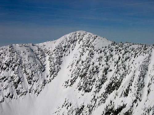 Murphy Peak
History
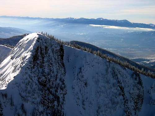 Mosquito Peak, Missoula and the Bitterroots in the background.
 (from USFS brochure found at trailhead kiosk)
The Rattlesnake National Recreation Area and Wilderness (RNRAW)has a long and interesting history. The are was used by the Salish long before settlers arrived in the 1800s. In 1972, human remains were found along Rattlesnake Creek that dated back to around 1460 A.D. The first known permanent white settler in the drainage was Bill Hamilton who settled near the mouth of Rattlesnake Creek in 1858 and operated a trading post until 1864. By the 1870s a neighborhood known as Shacktown was located on the west side of the creek just north of Missoula. By 1890, the upper Rattlesnake drainage (north of the Mountain Water Co. dam) had 12 residents. The population of the upper drainage skyrocketed and peaked at 139 people by 1910. In the early 1900s, there were as many as 19 homes in the upper drainage with amenities such as mail and newspaper delivery. In 1911, there was a phone line that ran up to the Franklin Guard Station and up over the ridge to Gold Creek. A school as built near the confluence of Spring and Rattlesnake creeks and operated from 1907 to 1930. The population had declined to 44 inhabitants by 1930.
The Montana Power Company built 10 dams on eight lakes in the present day Rattlesnake Wilderness between 1911 and 1923 to augment the water supply for the City of Missoula. These dams and the water rights were sold to Mountain Water Company in 1979 and are still operated and maintained today as a backup water supply for the City of Missoula. By 1937, Montana Power Company had purchased all the private land in the upper drainage on the west side of the Rattlesnake Creek to protect the watershed.
The National Recreation Area and Wilderness was established by an Act of Congress on October 19, 1980. At that time over one third of the area in the RNRAW was in private ownership. In 1983, over 21,000 acres in RNRAW were acquired by the Forest Service from the Montana Power Company. The main trailhead you see today was built in 1987. The horse trailhead was built in 1992.
There are at least two stories about how Rattlesnake Creek got its name. According to one account, a man bitten by a rattlesnake died in the 1800s while gathering firewoood along the creek. Another version suggests the namecame from the Salish word, “Kehi-oo-le,” whichmeans rattlesnake.
The upper RNRAW is less developed today than it was a hundred years ago when the upper drainage included cabins, farmsteads, mines, a school, a Ranger Station, motorized use, firewood cutting and outfitters. The Rattlesnake is a restoration success story. Today the main issues on the creek are recreation, noxious weeds and fuels management.