
|
|
Area/Range |
|---|---|
|
|
39.70930°N / 77.95486°W |
|
|
Hiking |
|
|
Spring, Summer, Fall, Winter |
|
|
2062 ft / 628 m |
|
|
Overview
 Gillians Knob
 Topo of the area
The Bear Pond Mountains are a part of the Appalachian Mountains, that are located along the Pennsylvania and Maryland border just west of Clear Springs Maryland. They are a part of the Ridge and Valley system and reach their highest point at Cross Mountain (Pennsylvania) 2,062 feet.
My biggest trouble while exploring for data and info on this range is its name. I have yet to find in my travels or on any map an actual place called Bear Pond. There is a Bear Pond Hollow that runs through the area but no actual pond named Bear Pond. So essentually there are the Bear Pond Mountains with the lack of a Bear Pond.
A unique feature known as the "Punchbowl" occurs in this range between Cross Mountain (PA), Hearthstone Mountain(MD) and Two Top Mountain (PA). The punchbowl was created by the weathered shales of the Ordovician age in the center of a south-plunging anticline, that having been eroded to expose a large amphitheater like feature called the punchbowl. Cross, Hearthstone, and Two Top Mountains are made of hard resistant quartzite which form the punchbowls walls.
The area in Maryland is mostly found within the Indian Springs Wildlife Management area, but also has private land. The summits of Cross Mountain and Hearthstone are off limits. Cross Mountain (in PA) has a tower that has secret military use. Some say it was used to send some kind of microwave signals during the cold war. Hearthstone Mountain has an AT&T Project Office on the summit but most rumors say it is not what it says it is. Most stories say it is actually some sort of top secret underground government FEMA bunker type thing. Not sure why AT&T would need an underground bunker.....makes you wonder. Some Internet sites say it is abandoned but I doubt it is considering that all the aerial data available shows cars in the parking lot and the place very well maintained. There are cameras and gaurd houses along the road to this summit so dont try going there!
Whitetail Ski Resort is also located in this range on Two Top Mountain in the Pennsylvania area.
The Major summits
of the Bear Pond Mountains:| Ranking | Mountain Name | Elevation |
| 1 | Cross Mountain | 2062 |
| 2 | Hearthstone Mountain | 2021 |
| 3 | Two Top Mountain | 1780 |
| 4 | Kasies Knob | 1760 |
| 5 | Fairview Mountain | 1690 |
| 6 | Rickard Mountain | 1637 |
| 7 | Cove Mountain | 1632 |
| 8 | Gillians Knob | 1575 |
| 9 | Bullskin Mountain | 1551 |
| 10 | Powell Mountain | 1548 |
| 11 | Sword Mountain | 1446 |
| 12 | Abe Mills Mountain | 1382 |
| 13 | Johnson Mountain | 1140 |
| 14 | Claylick Mountain | 1017 |
| 15 | Boyd Mountain | 987 |
Getting There
DirectionsFrom I-70, take the Clear Spring exit and travel north on Route 68. Cross Old Route 40, bearing left onto Mill Street. Continue to a fork and bear right onto Broadfording Road going east approximately 1 mile. Take the first left onto Blair's Valley Road. The entrance to the WMA is approximately 3 miles north. For more information, contact the Indian Springs Wildlife Office at (301) 842-2702.
Red Tape
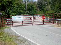 Gates to private land
 These areas are off limits
There are posted areas with very sensitive restrictions ("secret" government installations). If it says stay out stay out. No camping allowed other than along the lake on Blair's Valley Road. No fires allowed.
Camping
Primitive camping is permitted at the designated camping area on Blairs Valley Road. For information about camping at Indian Springs, please contact the office at 301-842-2702.Indian Springs WMA
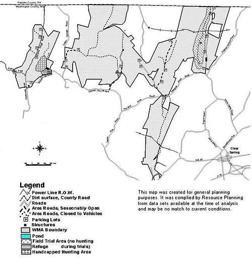 Basic Map of Indian Springs WMA
Indian Springs WMA
is a 6,400-acre tract in Washington County near the town of Clear Spring and Indian Springs, Maryland. Field trials, where man and dog display their outdoor skills, are held here six times a year. The majority of the site is dominated by forest consisting of oaks and other hardwoods, with some very steep hills. Fairview Mountain, located on the area, served as a Civil War military signal post.What To See
Visitors enjoy strolling a self-guided nature trail, learning about many plants which are used by wildlife. History buffs look for the ruined pioneer homesteads and family cemeteries that dot the area.
Non-hunting Users Guide
Non-hunting visitors are welcome.
Be aware of open hunting seasons and visit accordingly
Season dates available in newspapers, on the Internet, and at some area stores.
Trails are maintained but not actively marked.
Hardwood forests surround many of the trails and support a rich variety of song birds and other wildlife species, depending on the time of year.
Special Areas
The trail system noted on the map is suitable for hiking and birding as well as hunting.
Much of the field habitat in Blair's Valley is a designated field trial area.
The area has two ponds that are stocked with trout.
The larger 30-acre pond has a boat launch area.
Site Management Goals
The primary management goal of this WMA is to provide habitat for forest and upland wildlife. The agricultural fields at Indian Springs are planted to provide habitat and winter food for game and non-game wildlife.
Species routinely using the area are white-tailed deer, wild turkeys, mourning doves, cottontail rabbits, songbirds and waterfowl.
A 30-acre impoundment was built to provide habitat for ducks and other wildlife, and is also a popular fishing site.
External Links
Whitetail Ski Resort.Indian Springs WMA