
-
 39450 Hits
-
 85.36% Score
-
 20 Votes
|
|
Area/Range |
|---|---|
|
|
49.69500°N / 125.631°W |
|
|
Hiking, Mountaineering, Skiing |
|
|
Spring, Summer, Fall, Winter |
|
|
5085 ft / 1550 m |
|
|
Overview
 Marble Meadows Marble Meadows |
Located in Strathcona Provincial Park, west of the approximate centre of Buttle Lake and high above the watersheds of the Wolf and Phillips rivers, is the unique and wonderful Marble Meadows alpine plateau.
360 Million years ago, during the Permian Period, a limestone deposit approximately 300 metres thick, laid down following the decomposition over aeons of trillions upon trillions of ancient sea creatures, formed in the warm seas around the equator. Roughly 130 million years ago, the seabed south of the equator slid north and collided with the west coast of North America. The buckling process that followed thrust up areas of the sea floor that ultimately became Vancouver Island, the Queen Charlotte Islands and part of the Alaska Panhandle.
Many areas of Vancouver Island show evidence of this process but none more strikingly than Marble Meadows. The ancient seabed is still there today, complete with its marine fossils, in the form of incredible and incongruous limestone strata. Sometimes these are found as contiguous areas, sometimes embedded between layers of granite and basalt. As if the complex geology wasn’t enough, the erosive processes always associated with karst rock resulted in the creation of spires and columns of rock, sinkholes without number and disappearing and reappearing watercourses.
Although nominally described as a “plateau” Marble Meadows is far from flat. The forces that formed the rest of Vancouver Island were not miraculously absent here. Limestone, basalt and granite all buckled and heaved together forming mountains, ridges, alpine bowls and the lakes that eventually filled them. In summer add an alpine flower display to dazzle the senses and you have a recipe for enchantment. Without question Marble Meadows is one of the primary “must-see” areas of Strathcona.
Initial access is by boat since there are no roads on the west side of Buttle Lake. Once across the lake, however, a well-engineered switchback trail takes the hiker up to the crest of the plateau in about 4 hours. This means that the area is quite popular and its popularity is only enhanced by the fact that this is the eastern approach for those wanting to climb The Golden Hinde, the highest peak on the Island.
In winter the plateau often receives more than 10 metres of snow accumulation and is a ski touring destination par exellence.
Getting There
Vancouver Island can be reached by air from Toronto, Vancouver, Seattle, Calgary and Edmonton to Victoria, Nanaimo, Comox or Campbell River and by ferry from Port Angeles to Victoria on The Coho and on BC Ferries from Vancouver to Victoria or Nanaimo. Public transport on the Island is notoriously poor and anyone arriving by air would be advised to rent a car. Road access involves driving only on paved roads, so a normal 2WD sedan is fine.
From Campbell River, at the end of the freeway section of the Inland Island Highway 19, take highway 28 west towards Gold River. After approximately 30 km the road meets Upper Campbell Lake and after 47 km you will enter Strathcona Park at Elk Portal. Exactly 1 km further on, highway 28 makes a right turn over the bridge at Buttle Narrows. Ignore the turn and carry straight on down the paved Buttle Lake Parkway (also known as Westmin Mine Road). 21 Km after passing the turn-off for Gold River, park at the Augerpoint day use area if you are using a canoe or kayak. If you’re using a power boat it can be launched from Karst Creek a few kilometres beyond Augerpoint or simply launch it from Parks’ campground at Buttle Narrows – just across the bridge to Gold River – and motor 15-20 minutes down the lake.
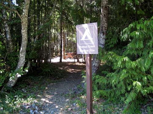 Phillips Creek Campsite Phillips Creek Campsite |
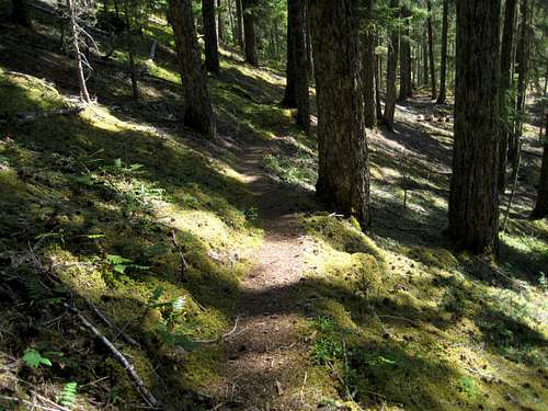 Marble Meadows Trail Marble Meadows Trail |
Cross the lake to the outlet of Phillips Creek, where there is a marine camp-site with facilities. Avoid a late afternoon crossing in a small craft. Winds funnelling up the valley can make the lake very rough.
From Phillips Creek, Parks’ excellent, switchback trail takes you in about 4 hours up to the plateau crest. Make your base camp by any of the stunning lakes west of here or proceed to the A-frame Wheaton Hut – the only such hut in Strathcona Park – with Wheaton Lake nearby. Well cairned and booted-in paths follow the north side of Limestone Lake and traverse both sides of Globeflower and Marblerock Lakes to the Wheaton Hut in 1-2 hours from the crest.
I have given the coordinates of the hut in the page header as the approximate centre of the area.
The Topography.
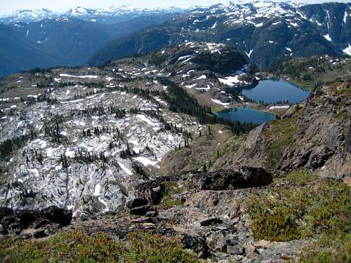
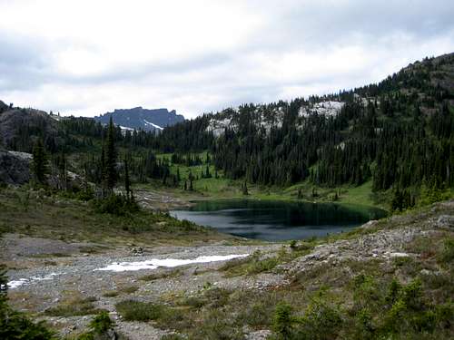
Marble Meadows is (very) approximately 12 square kilometres in area. The terrain in the eastern part is open and comparatively flat but becomes more undulating and forested to the west as one passes Globeflower Lake.
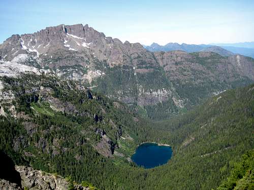
The eastern border of the area is well defined by the abrupt crest of the plateau. One minute you’re climbing forested hillside up from Buttle Lake and the next you’re on a flat limestone and granite slab just east of Limestone Lake. To the north Marble Peak and Wheaton Ridge dominate, while to the south, the plateau drops abruptly into the Phillips Creek valley far below.
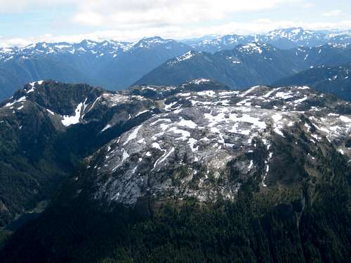
 East Side of Marble Meadows East Side of Marble Meadows |
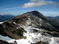
 Marble Meadows from McBride Marble Meadows from McBride |
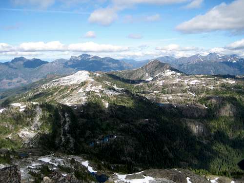
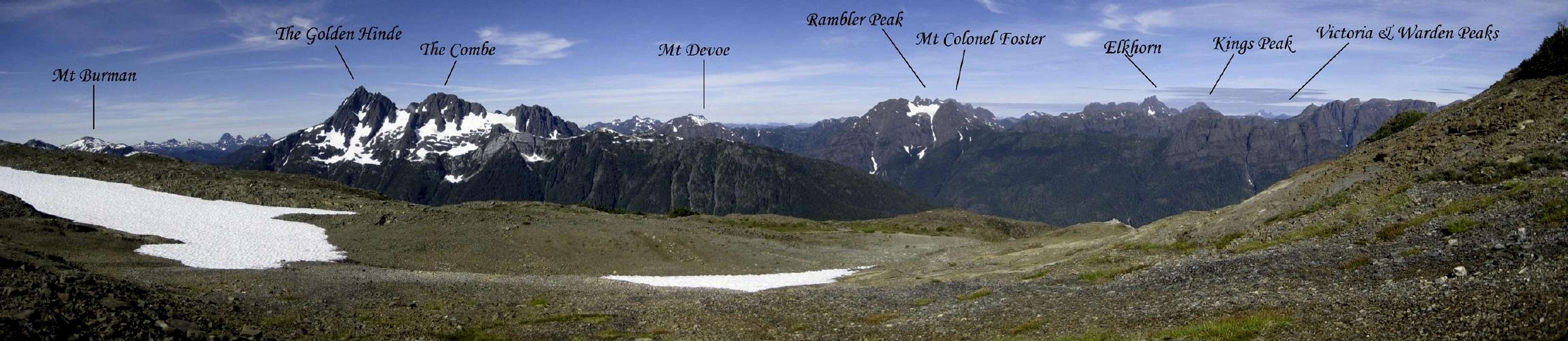 An approximately 150° panorama of Strathcona Park from the west boundary of Marble Meadows. SP descriptions are available for: The Golden Hinde, Mt Colonel Foster, Elkhorn, Kings Peak, and Victoria Peak. Click at left . |
The Mountains
Three principle summits surround Marble Meadows.Marble Peak to the immediate north of the east side of the plateau and Morrison Spire and Mt McBride to the SW and NW respectively.
Marble Peak is composed principally of granite with several prominent limestone bands, particularly lower down. McBride is mostly basalt and Morrison mostly granite. Between the latter pair is a ridge that is composed of a mixture of all three rock types. The diversity of the geology on three closely proximate mountains is typical of the area.
 Southern summits Southern summits |


South, beyond Morrison Spire, a well travelled track heads towards Phillips Ridge and on south to the exit point at Strathcona Westmin. See the SP posting for the Golden Hinde for further details. Alternatively, the hiker can head west, across the head of the Wolf River valley, down to Schjelderup Lake, up to the north ridge of Mt Burman and on to the Golden Hinde from there.
Between Morrison Spire and the junction of the route with Phillips Ridge is a series of unofficially named peaks. In order, from north to south are: Limestone Cap, Tibetan Mountain, Crystal Mountain and Mt Judy. The most northerly two peaks are often visited as part of a trip to Marble Meadows. The latter pair are climbed more often as part of the route in to the Golden Hinde.
The Lakes.
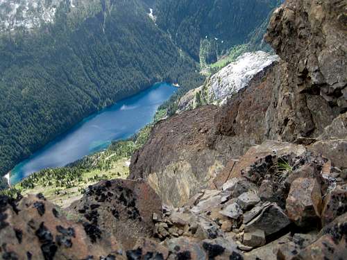
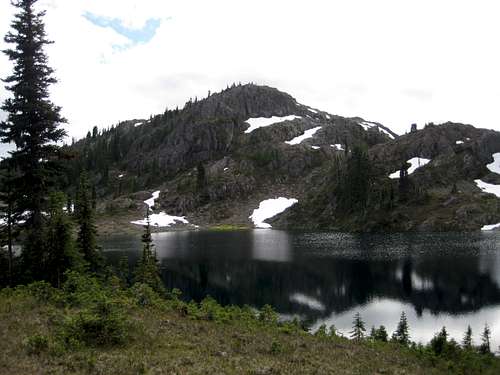
The forces responsible for the formation of Marble Meadows left a topography full of natural bowls that formed the countless lakes found throughout the area.Most of the lakes drain south into Phillips Creek. Arguably the loveliest, Marblerock Lake, drains north down the canyon of the same name. All of the lakes, large and small, named and unnamed, dump their waters in the end into Buttle Lake, 1,300 metres below.
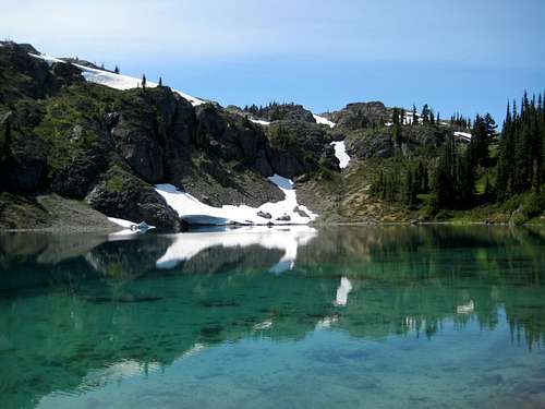 Marblerock Lake Marblerock Lake |
 Copperbush Lake Copperbush Lake |
 Limestone Lake Limestone Lake |
Approximately 400 metres below the average level of the plateau and to the north lie the sub-alpine Copperbush and Hellbore Lakes. Although rarely visited, these lakes are clearly visible from many points on the plateau and this description would not be complete without including them.
 Globeflower Lake Globeflower Lake |
 Hellbore Lake Hellbore Lake |
Globeflower Lake |
The Rocks and Fossils.
It isn’t just the existence of such a diverse range of morphology that makes Marble Meadows so fascinating. It’s more about the way that it’s all jumbled together, almost as if some prehistoric molten rock chef suddenly decided that he’d had enough of making a homogeneous mix out of all this stuff, gave it up as a bad job and wandered off in search of something better to do, like trying to stop that little monkey with the opposed thumbs from asking him questions all the time. Thus, one finds a pure limestone tower with a band of knobby basalt running through it, or a cliff face consisting of 6 or 7 alternating bands of granite and karst, or studs of basalt sticking barnacle-like to a limestone boulder. Wonderful stuff even before all those sinkholes and the mystery of why that creek suddenly disappeared.
 Limestone and Basalt Limestone and Basalt |
 Limestone and Granite Limestone and Granite |
 Limestone/Granite Strata Limestone/Granite Strata |
 Sinkhole Sinkhole |
The most common fossils seen in the rocks of Marble Meadows are “crinoids”. So much so that their debris tends to swamp other species. Crinoids, also known as “sea-lilies,” were primitive stalked creatures that spent their lives rooted to the seabed.
Also relatively common are “brachiopods,” or "lamp shells." These are found as broken shells throughout the limestone substrate. These cockle-like animals were abundant during the Paleozoic Era. They generally lived in shallow water attached to rocks or another solid host.
To visit to Marble Meadows is, literally, to walk on an ancient ocean bed and wouldn’t be complete without a fossil hunt. In point of fact, there’s not much “hunting” required. Look down in almost any limestone area and these ancient visitors to our time are there to seen by the thousands.
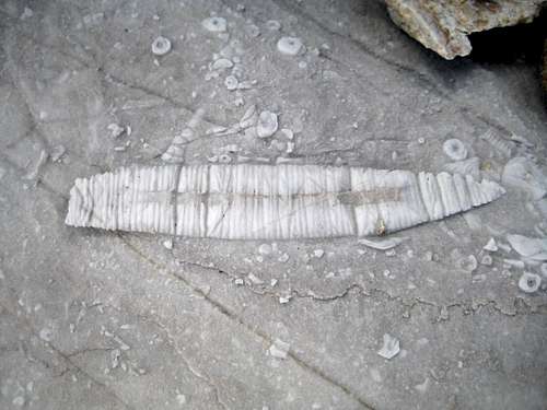 Crinoid and Brachiopod fossils
The Hut.
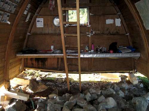
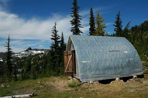
Yes, almost unique in Strathcona Park, Marble Meadows even has a public hut.The Wheaton Hut was built in 1970 by the pupils and staff of Shawnigan Lake School in memory of Billie Wheaton, a student at the school who was killed in a climbing accident in the Swiss Alps in 1967. In those days, unlike today, there was nothing in the Park’s management criteria forbidding such a structure. The hut was built at the school’s and Wheaton family’s expense, with the blessing of Parks and its status is protected by the legal mechanism of “grand-fathering” to this day.
The hut is a tiny, basic structure clad in aluminium against the ravages of an annual load of 10 metres of snow, or more. Inside is a cooking bench, a sleeping loft for 2 or 3 and little else. Nevertheless, it’s a cozy, welcoming shelter from the storm. You can feel the good vibes as you step through the door. I would guess that it would accommodate 6 people comfortably, although the logbook provides ready evidence that a dozen or more people have crammed in from time to time when needs must.
 Wheaton Hut Renovation Wheaton Hut Renovation |
 Raising the Hut Raising the Hut |
 Wheaton Hut Wheaton Hut |
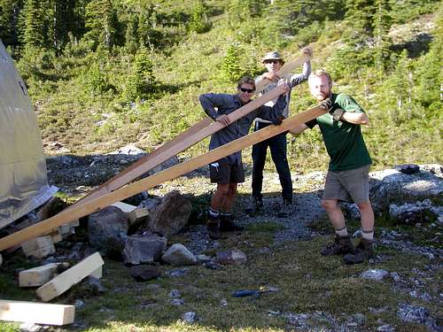
In August 2008, a volunteer group from the school, backed by the family, spent nearly a week on site and completely re-built the problem footings that had finally had their day.
The guys raised the hut on a system of levers and brute force, hand-poured new footings and re-established the floor on this stable new base. This was a huge job to do by hand. The only power they had was what was in the batteries of their tools. Concrete was prepared in a tarpaulin “mixer”. When everything was complete, the guys then carried the building debris out on their backs! The hiking fraternity on Vancouver Island owes them a great deal.
Red Tape
None. You’re outside the Strathcona core area where camping fees are due.Camping
Anywhere you like in Marble Meadows or save yourself the extra weight of a tent and stay at the Wheaton Hut. But please respect this beautiful and delicate place. Stay on trails even near campsites, hang food bags out of reach (even in the hut), clean up all cooking scraps, practice good toilet discipline etc.Giardia is well documented throughout Strathcona Park, so boil or treat all water.
Fires are strictly prohibited, so you must pack a stove.
Bear and cougar frequent the mountains and forests of Vancouver Island, so hang or otherwise isolate all food at night.
Suggested Reading
Island Alpine – A Guide to The Mountains of Strathcona Park and Vancouver Island, Philip Stone, Wild Isle Publications, 2003, ISBN 0-9680766-5-3 and/or visit Island Alpine Climbing GuideBeyond Nootka – A Historical Perspective of Vancouver Island Mountains, Lindsay Elms, Misthorn Press, 1996, ISBN 0-919537-29-4 and/or visit Beyond Nootka