
|
|
Area/Range |
|---|---|
|
|
43.22545°N / 18.76269°E |
|
|
Spring, Summer, Fall, Winter |
|
|
7864 ft / 2397 m |
|
|
Wild Pearl of Montenegro
 BIOČ massif
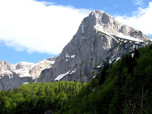
There is no such high mountain range which is so fantastic and incredible that could compare with DURMITOR and PROKLETIJE, but at the same time not so visited, even unsufficciently known to mountaineers, as is BIOČ (BIOC, read "BIOCH"). Maybe the most important reason for that is the fact that Bioč is not so rich with water springs. Also, the climbing of each peak on Bioč is a wholeday route. In any case, together with DURMITOR, PROKLETIJE and KOMOVI, BIOČ range belong for sure to the group of 4 most beautiful and most impressive mountain ranges of Montenegro. Together with mountain ranges of Maglić, Volujak and Vlasulja, Bioč create a beautiful mountain area with many high peaks, beautifully lakes, valleys and plateous. From all of them, Bioč is the highest one with its Veliki Vitao (2397 m) peak. Bioč is also the highest mountain range in NW part of Montenegro. Bioč range stretches between the Stabanska Jezera lakes on the south, Pivsko Jezero lake on the east, Mratinje valley on the north, and is connected with Maglić, Trnovački Durmitor and Volujak mountains.
Bioč mountain has a specific, unique and chaotic outlook and its wildness is the main reason of its amazing and impressive beauty. Most impressive group of the peaks in Bioč are Vitlovi peaks, specially their north side which you can see from one very special point, placed 1 km north from Veliki Vitao. That amazing point is called Bubreg (2339 m). If you want to witness amazing and impressive outlook of Bioč and specially its Vitlovi group, don’t miss Bubreg!
In the Bioč massif which is long and wide about 10 kilometres are placed many impressive peaks.
Here is the list of the highest peaks of BIOČ range:
- Veliki Vitao (2397 m)
- Bubreg (2339 m)
- Zmajeva Stena-Sedlo (2321 m)
- Vrsta (2301 m)
- Nož (2299 m)
- Bioč (2297 m)
- Srednji Vitao (2280 m)
- Zmajeva Greda (2273 m)
- Gredelj (2264 m)
- Mali Vitao (2220 m)
- Biočke Grede (2195 m)
- Televića Lastva (2193 m)
- Velika Lastva-Konjska Lastva (2118 m)
- Jajac (2100 m)
- Gradina
- Klekovo Pleće
- Rudina
 Winter on BIOČ - Vitlovi peaks
Bioč range is not so rich by green plateus and water springs. Preciselly, there is very difficult to find a water. The highest peaks of Bioč massif are surrounded by rocky glacial cirques. Some mountain writers called that area “Rocky Desert”. Peaks as are Veliki Vitao, Mali Vitao, Bubreg, Vrsta and Nož with their impressive and sharp vertical cliffs will lose your breath.
Bioč range is not good known and popular like neighbour Durmitor range, but in any case that range deserve full attention and respect. Veliki Vitao and other highest peaks of Bioč range visit just a real mountain devoters, good knowers and special mountaineers.
 Impressive Vrsta (2301 m) peak
Bioč massif is fine decorated by two beautiful lakes – Veliko Stabansko Jezero lake at 1325 m (300 m long, 190 m wide, maximum depth of 10 m). and Malo Stabansko Jezero lake at 1194 m (in summer it is 160 m long, 150 m wide, 4.5 m deep) in the Stabna Valley where is Bioč separate from Lebršnik and Volujak.
Routes Overview
 BIOČ massif from Pivska Planina
Stabna (1050 m) – Veliko Stabansko Jezero lake (1325 m) 1.30h – Zemunica (1598 m) 1.30 h – Ćuprija Pass (2196 m) 3h – Veliki Vitao (2397 m) 30 min: 6.30h
The starting point of the route is at the last houses an old shepherd’s path (there is a forest road that leads to the Malo Stabansko Jezero lake) which ascends steeply northwest through the forest, tracking the Stabanska river bed. Pass the Malo Stabansko Jezero lake. Then another ascent northward through a wood to the Veliko Stabansko Jezero. The route continues eastward, along ravines to the fountain spring of Zemunica. From that point, the path climbs northerly, through boulders, over grassy karst holes to a dried up rainwater reservoir called Ubline located in the Smrekovac cirque. Continue northward, along a livestock trail to the Krvava Brda foothills. The ascent starts from the road, at the point closest to he vale between Biočke Grede and Vitlovi. Steep grassy and rocky terraces, first downward through rubble and then through a small piney wood (Pinus mugo), the path turns northeastward to the rocky Klisura valley. The visible trail leads to the Ćuprija pass. From the pass to the summit, follow along the southern side, over a grassy slope.
 Vitlovi peaks in BIOČ range
 From Durmitor
 From Vlasulja
Trnovačko Jezero lake – Rudinske Kolibe shepherd houses – Bojanska Vrata pass 2.30h – below Ordeni Dolovi valley – above Smrekovac plateau – Veliki Vitao (2397 m) 2h: 4.30h-5h
This route start from Trnovačko Jezero lake. Ascending from that lake, after about 10 minutes you’ll notice a marked sign which show you the path to the left to Trnovački Durmitor, then the path to the right to Badanj, and finally the middle path which goes to Trnovačke (Rudinske) Kolibe houses. The path continue near that houses and through the right side of valley, and after that across the rocky terrain and to the left across the pass. From Trnovačko Jezero lake to that pass you’ll spend about one hour or little beat more. After that the path enter into the valley between the peaks of Volujak massif on the right and peaks of Trnovački Durmitor on the left. From here, to reach Bojanska Vrata pass you need about 1.15h. When you come on Bojanska Vrata pass, from that place you’ll enjoy in incredible view to Bioč massif. From the pass you can go on the right side of the valley called Ordeni Dolovi. Than go left below the Ordeni Dolovi and above the Smrekovac basin, in direction of Veliki Vitao peak. Second option is to go to Stabna plateau and from there ascend to the pass from where is possible to reach the summit of Veliki Vitao peak. From Trnovačko Jezero lake to the summit of Veliki Vitao you need about 5h by walk.
 Zmajeva Greda (2273 m) from Pivsko Jezero lake
 Vrsta (2301 m) above the Veliko Mratinjsko Jezero lake
Stabna (1050 m) – Kručica (1500 m) – Smrekovac plateau (1700 m) – Veliki Vitao (2397 m): 5h
Kručica (1500 m) – Biočko Ždrijelo (2040 m) – Bijelačka Voda (1930 m) – Veliki Vitao (2397 m)
OTHER ROUTES:
Smrekovac (1700 m) - Košara (1960 m) - Previja (2240 m) - Bubreg (2339 m)
Mratinje - Krč village (1000 m) - Katun Presjeka (1900 m) - Vrsta (2301 m) - Sedlo (2321 m)
Trnovačko Jezero lake (1513 m) - Urdeni Dolovi (1860 m) - Prevoj Presjeka (2070 m) - Vrsta (2301 m) - Sedlo (2321 m)
 BIOČ massif
Getting There
 Maglić, Trnovački Durmitor, Bioč and Trnovačko jezero from Volujak
From Montenegro
Podgorica - Nikšić - Plužine - Stabna - Bioč (shortest approach)
Podgorica - Nikšić - Plužine - Mratinje - Trnovačko Jezero - Bioč (longer approach)
From Serbia
Belgrade (Beograd) - Loznica - Mali Zvornik - Zvornik - Višegrad - Tjentište - Prijevor - than by walk to Trnovačko Jezero lake (shortest approach)
Belgrade (Beograd) - Ljig - Čačak - Užice - Zlatibor - Nova Varoš - Prijepolje - Pljevlja - Đurđevića Tara - Žabljak - Virak - Sedlo - Trsa - Plužine - Stabna - Bioč (longer approach)
Belgrade (Beograd) - Ljig - Čačak - Užice - Zlatibor - Nova Varoš - Prijepolje - Pljevlja - Đurđevića Tara - Žabljak - Virak - Sedlo - Trsa - Mratinje - Trnovačko Jezero - Bioč (longer approach)
From Bosnia and Hercegovina
The M-20 highway from Foča/Srbinje to Gacko, which crosses through Tjentište, is the starting point for the approach to these peaks.
It can be reached by following the M-5 highway easy out of Sarajevo.
Camping
 Trnovačko Jezero area
 Trnovačko Jezero
 Before and after climbing of the peaks of BIOČ range, you can freely camping on many places around and below the mountain. First of all, you can camping near Trnovačko Jezero lake, near Veliko Mratinjsko Jezero below the Vrsta peak, than in the Stabna Valley near Veliko Stabansko lake and Malo Stabansko lake.