
-
 59012 Hits
-
 90.48% Score
-
 32 Votes
|
|
Area/Range |
|---|---|
|
|
35.66622°N / 82.30408°W |
|
|
Hiking |
|
|
Spring, Summer, Fall, Winter |
|
|
5240 ft / 1597 m |
|
|
Overview
 This trail map of the range, provided by mlandau3, can be expanded to full size by clicking, clicking again, then clicking a third time
The Seven Sisters are a locally well-known, much-beloved range above Montreat and Black Mountain, N.C. The range is only about three and a half miles long, encompassing seven neatly ascending “sisters” leading to their “father,” Graybeard Mountain. Four of the sisters are presently on Summitpost.
The range is a delight to traverse from one end to the other. A marked trail, the West Ridge Trail, runs from the second sister to Graybeard.
Nomenclature
You will not find the name “Seven Sisters” on any USGS map, but it is nonetheless by far the most common name for these mountains in use today. It was in widespread local use in the early 20th century, if not earlier. Locals almost never use the name “Middle Mountain” that appears on recent USGS maps. A third name, “Walkertown Ridge” (USGS 1907 quad; C.E. Ward, 2008), has mostly disappeared from general usage, but when it is used it encompasses the Seven Sisters and Graybeard together.Identification
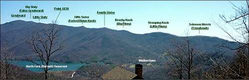 The Seven Sisters from the west
The individual sisters are often misidentified, and The main problem is that people think they can see the top of Graybeard from Black Mountain and Montreat—whereas in general they cannot—and they think the last “sister” they see is Graybeard. In fact, Graybeard is not a sister (although it is part of the range) and its summit is invisible from many viewpoints to its south. The City of Black Mountain used to have a sign board at Lake Tomahawk that included at least three misidentifications, but to the eternal credit of the municipal government, this has been corrected with a brand new, perfectly accurate sign as of 2016.
There is a good discussion of the correct identification of the sisters in Professor Perrin Wright’s book, “Geographic Place Names In and Around Montreat, N.C. (2003), at pages 26-29. The pictures below identify the sisters from two angles.
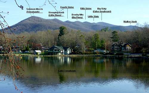 The Seven Sisters from Lake Tomahawk in the town of Black Mountain
The Peaks
 The sisters are numbered on the map above, which uses the alternative name "Middle Mountain" for the range
1. Solomon Morris (Tomahawk), 3680’+. No official trail.
2. Stomping Knob (Little Piney), 3995’. Reached by the Little Piney Ridge Trail; the West Ridge Trail begins on this summit and continues on the crest of the range to Graybeard.
3. Brushy Knob (Big Piney), 4180’+. Reached by the Big Piney Ridge Trail or the West Ridge Trail. It is the first of the sisters with a year-round view--Rattlesnake Rock, with a fine southward outlook, is located a couple of hundred feet below the top on the Big Piney Ridge Trail.
4. Unnamed Fourth Sister, 4360’+. A very short hop from Brushy Knob via the West Ridge Trail. There is virtually no saddle between the two, making Brushy Knob little more than then shoulder of Fourth Sister, but they appear as distinct summits from some angles. A photograph of Fourth Sister (along with Brushy Knob) is located here. The top is almost viewless, offering just a glimpse of the Craggies through a gap in the trees.
5. Unnamed Fifth Sister (“Forked Ridge Knob” on 2005 Montreat Trails Map), 4511’. A pretty peak traversed by the West Ridge Trail.
6. Little Slaty Mountain, 5000’+. So named as early as the mid-nineteenth century. Traversed by the West Ridge Trail.
7. Big Slaty Mountain (False Graybeard), 5240’+. The West Ridge and Graybeard Trails join on this summit. Big Slaty has only about 15 feet of prominence (that is, it rises only about 15 feet from its "saddle" with its higher neighbor, Graybeard), making it essentially the south shoulder of that mountain.
Graybeard Mountain, 5408’. Not one of the sisters, but their parent in every way and certainly a part of the range in that it is the endpoint of their ridge. Graybeard (unlike the sisters) is also on the main crest of the Blue Ridge and the Eastern Continental Divide. On a clear day, it is readily visible from Marion and the lowlands farther east.
Ownership and Red Tape
The watershed of the North Fork (Burnett) Reservoir, representing the whole western flank of the range from the fourth sister northward, is Asheville Watershed land off limits to hiking of any kind. Hiking the crest, along the boundary of this restricted region, is permissible.Most of the eastern flank of the range is privately owned by the Mountain Retreat Association, which operates the Montreat Conference Center. Hikers are welcome, but camping is not permitted. You also can't mountain bike on any of Montreat's trails on the Seven Sisters (although there are other places in Montreat you can do so).
The remainder of the range is in the hands of a number of private landowners, including a large tract in Little Piney Cove and on the east side of Solomon Morris that belongs to the Billy Graham family.
Links and Sources
Link to latest Montreat trails mapPhotos in different weather moods
Seven Sisters Trail Run (25k, 4000 feet of climbing)
Trip report on climbing Greybeard from Blue Ridge Parkway
C.E. Ward, "Organized Camping and Progressive Education" (2008), p. 56.
P. Wright, “Geographic Place Names In and Around Montreat, N.C." (2003), pp. 26-29.
Rock Hill, S.C. Evening Herald, Nov. 1, 1938 (use of "Walkertown Ridge" as a name; early use of the name "Brushy Knob" for third sister).
mlandau3 - May 8, 2011 4:10 pm - Hasn't voted
You Should Probably Replace The MapThere's now a trail (the Lower Piney Trail) that connects the Big Piney Trail with the Stomping Knob Trail.
chugach mtn boy - May 8, 2011 4:33 pm - Hasn't voted
Re: You Should Probably Replace The MapHey,thanks for the heads up. I can get the new map when I'm back there this fall, but if you have it yourself, by all means please scan it and post it as an image attached to this page. I can then change the links on the main page.
mlandau3 - May 15, 2011 1:54 pm - Hasn't voted
Re: You Should Probably Replace The MapI attached a copy of the new map to the images.
chugach mtn boy - May 15, 2011 2:15 pm - Hasn't voted
Re: You Should Probably Replace The MapMuch obliged. I've put it up on the main page.