
|
|
Mountain/Rock |
|---|---|
|
|
9868 ft / 3008 m |
|
|
Overview
This mountain route is the longest one at Java Island. In the map, this route is almost 30 kilometres far. It's located at 3 different states, Probolinggo, Bondowoso and Jember. And all that state located in East Java Province.
There is a lot of peak at this mountain, but only two peaks whish usually climber visited. They are Argopuro Peak and Rengganis Peak.
There are two start point that usually used by climber who visited here. From Baderan or from Bremi. Baderan located at Bondowoso or Besuki and Bremi located at Probolinggo.
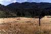
If we taking Baderan as the start point, we'll see a beautiful panoramas along this route. We'll see a tropical rain forest, and then long long savana, and may would make us bored besause we'll across along this savana almoust all day hiking.
But there is a few point of this route that we can take a rest here.
If we take form Baderan, after hiking about 6 hours we'll come to 1st water point (mata air 1)
and then from mata air 1 we'll come to mata air 2 (2nd water point) after 3-4 hour in hiking.
From Mata Air 2 we'll trekking to Cemoro Panjang taking about 1-2 hours. this may one of the hardest route.
And then after we reach Cemoro Panjang, we will come to Alun-Alun Kecil. From this point we will see a long trip of savana before comes to Cikasur / Alun-alun Besar. It's take at least 3-4 hours.
There is a lot story of Cikasur. Before 1945, this place became a Japan's aircraft landing, that hidden between hills. So the Indonesian soldiers could detect this place.
At this place, we usually could watch peacock, belibis, pigs, monkey at aerly morning or late afternoon. It's beautiful view's here, besides a small river down this camping area with it's fresh water and water salad on it.
After here we should move to Cisentor (Aeng Poteh / air putih / White water area).This is could be our last camping point before reach summit.
And from Cisentor, we can go to the peak via Rawa Embik. If we take the right side of the route from Rawa Embik, we can reach peak of Argopuro.
And when we take the left side of the route from this place, we can reach Rengganis peak (in map it's named Welirang peak).
When we want to go back, we can choose 2 options. Back to Baderan (our start point) or continue to Bremi (our finish point later).
If we continue to Bremi, we'll pass Aeng Kenik (one of water point), and then Danau Taman Hidup (Life Garden Lake).
From Danau Taman Hidup, we can reach Bremi, our finish point in 3 hours.
 |  |  |  |
Getting There
1. If we start from Baderan
From Malang
Malang - Probolinggo (riding bus, 3 hours)
Probolinggo - Besuki (riding minibus, 3 hours)
Besuki - Baderan (riding microlet, 1.5 hours)
From Surabaya
Surabaya - Besuki (riding bus, 4 hours)
Besuki - Baderan (riding microlet, 1.5 hours)
2. If we start from Bremi
From Malang
Malang - Probolinggo (riding bus, 3 hours)
Probolinggo - Bremi (riding microlet, 1.5 hours)
 |  |  |
Red Tape
This mountain is wildlive conservation areas, under Balai Konservasi Sumber Daya Alam Jawa Timur (Natural Resource Conservation House, East Java).
If we want to climg here, we should get a permission letter from BKSDA Jawa Timur. It take Rp. 10.000,00 (ten thousand rupiahs).
This letter called SIMAKSI (Surat Ijin Masuk Kawasan Konservasi) or Permission Letter For Entering Conservation Areas.
This Mountain consist a lot of protected animals, such as birds, mamals, Apes, reptils, etc.
 |
When To Climb
There is only two season in Indonesia. Dry season and wet season.
Both seasons are safely if we want to climb Argopuro.
In dry season, this possible a burning grass a long savana happened.
But in wet season, we'll pass the hardest route because it's very slidy.
 |
Camping
We allowe to camp here along of the route.
And there a lot of camping ground, especially it have water point.
there are:
1.Mata air 1 (1st water point)
2. MAta air 2 (2nd water point)
3. Cikasur / Alun-alun Besar
4. CIsentor /Aing Poteh
5. Danau Taman Hidup (Life Garden lake)
 |  |  |  |  |
Mountain Conditions
If we want to know much about this mountain, you may visit a supported website below:
www.merbabu.com
www.highcamp.web.id
External Links
- get more info from this website
- see more information from this site
- Global Volcanism Program
By the National Museum of Natural History, Smithsonian Institution
David Donaldson - Oct 8, 2004 11:08 pm - Hasn't voted
Untitled Commentif coming from Baderan you can not rely on water until you reach the airstrip campsite. it is a long way from Baderan but the only reliable water on this part of the trek. It is spring fed and we drank it straight out of the ground. Next water is Cisentor about 2 hours on. Here the track splits, to summit and out to Bremi. The water here is a stream and OK but needs to be boiled/treated. 2 hours further on is the campsite of Rawa Empik with a small stream on the right.
Heading back to Bremi there is a stream an hour or so past Ci Sentor which is good water. This is the last good water until Bremi! Taman Hidup Lake is polluted with Pig and Human excrement. Our filters were plugging up in less than a liter of water processed.
David Donaldson - Oct 8, 2004 11:10 pm - Hasn't voted
Untitled CommentThis is one of the few mountains in Java where wildlife is still abundant. From the camp at the airstrip we saw Deer, Pigs, Pheasant, Gibbons and bush fowl.
A very noisy place in the morning.
David Donaldson - Oct 8, 2004 11:26 pm - Hasn't voted
Untitled CommentTo do this hike comfortably you need three days from either Baderan or Bremi. Normally one starts from Baderan.
Set off as early as possible wit enough water for the whole day. 4 liters at least.
First camp should be at the airstrip about 8 hours in and up. Huge open tussocklands.
Next camp should be at Rawa Empik about 4 hours from airstrip. The campsite at Ci Sentor is pretty grubby but Rawa Empik is quick nice. No real views from either. From Empik you can go to the summit the same day or leave early in the morning at daybreak.
From Rawa Empik it is a long day out to Bremi with numerous ascents! We camped at Taman Hidup lake but no one was happy with the conditions. We won't do this again but head out to the road and stay in a losman somewhere. It is about 2 hours from here to the road all down hill.
next year we will camp at the airstrip then push on and camp at the summit of Reganis for possibly 2 nights then head out in one day leaving very early. No water at the summit so will need to load up in Rawa Empik.
The temple summit here is one of the most magical summits in Indonesia. To camp and explore here would be amazing. Can't wait till next year!