
-
 21584 Hits
-
 75.81% Score
-
 6 Votes
|
|
Mountain/Rock |
|---|---|
|
|
49.67056°N / 125.47195°W |
|
|
Hiking, Mountaineering |
|
|
Summer |
|
|
6033 ft / 1839 m |
|
|
Overview
 Augerpoint Mountain Augerpoint Mountain |
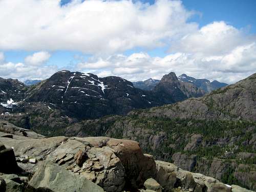
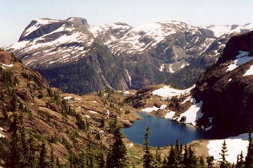
Thanks to the proximity of a ski resort, access is trivial. The route starts at ~1,000m in the sub-alpine, crosses a second watershed in its entirety and finishes in the base of a third. As well as Augerpoint at 1,839m, 2 other summits – Mount Albert Edward (2,093m) and Syd Watts Peak (1,856m) - can be bagged along the way. After the first 3 or 4 hours there is no marked path other than the occasional flag or cairn and any parties travelling the route should carry the right map, a compass and/or GPS and know how to use them. Once past the summit of Mt Albert Edward it is very unlikely that you will encounter anyone else. If all 3 summits are contemplated, prepare for a trip of 3 days over trackless mountain terrain involving over 2000m of total ascent and nearly 3000m of descent. Although there is no denying that this is a difficult trip and definitely not for the beginner, if properly prepared for, it can be immensely satisfying, not to mention enjoyable. Except for a short section on the second day and the final 2-hour descent through old growth forest to Buttle Lake, the route lies entirely in open sub- or high-alpine with spectacular, uninterrupted views of almost all of the high peaks of Strathcona Park.
The best time to go is September when the bugs have died off, although anytime from June to October would be feasible. I have not heard of anyone going beyond the summit of Mt Edward Albert on skis but this isn’t to say that it’s not possible nor, in fact, that someone has done it.
Getting there and other logistics
Vancouver Island can be reached by air from Vancouver to Victoria, Nanaimo or Campbell River and by ferry from Port Angeles to Victoria on The Coho and on BC Ferries from Vancouver to Victoria or Nanaimo. Public transport on the Island is notoriously poor and anyone arriving by air would be advised to rent a car. Access in this case is all on paved roads and, therefore, fine with a normal sedan.Approach from north or south on the inland Island Highway 19. Near Courtenay take the Strathcona Parkway exit west to Mount Washington Alpine Resort (the reason for the paved road to 1000m). Drive up 20km and just before reaching the resort make a left turn onto Henry Road, following Parks signs for Paradise Meadows. Pass the bottom of the ski lifts after 1.5km and drive a further 0.5km to the end of the paved road at the cross-country facility Raven Lodge.
Parks have established a new trailhead and information booth right beside the lodge. If you get back to your car before 5.30 pm, the Raven Lodge has a lovely view over to the mountains and is a great place for the beer you so rightfully deserve!
This is a point-to-point route with a road distance separation of 120-130 km so the logistics of pick up need to be addressed. The easiest, of course, is to get dropped off at Paradise Meadows and picked up from Westmin Mine Road on Buttle Lake three days later. More on exactly where to get picked up later. Failing this, the next choice is the two-car shuffle. Leave a vehicle at the western end and drive back to Paradise Meadows to start. Ambassador Transportation in Courtenay offers shuttle service to either end of the route for drop off and/or pick-up. Failing all of these, hitchhiking is your remaining option. In season, traffic volume on Westmin Road would be sufficient enough to make this possible. There are plenty of tourists visiting the Park as well as mine workers who live in Campbell River or vicinity who drive the road regularly and who may pick you up. Obviously you shouldn’t expect to get a ride from a mine vehicle on official business. Once in Campbell River there is limited bus service to Courtenay. From Courtenay you still need to get back to your vehicle at Mt Washington. Taxi (~$50) or reverting to the thumb are the options. The good news is that plenty of traffic goes up Strathcona Parkway to the resort and hitchhikers travel the route frequently.
Route Description
You only need complete formalities at the Paradise Meadows trailhead in the unlikely event that you intend to camp in a core area of Strathcona Park. In this case there is a $5/person/day fee for using the backcountry campsites at Kwai or Circlet Lakes. In practice, you will leave the core area far behind on the first day.Day one.
The first 7-8 hours of the route are exactly as described on SP for the ascent of Mount Albert Edward. The only thing to bear in mind is that you are carrying a full pack and times will be somewhat longer than described in that posting.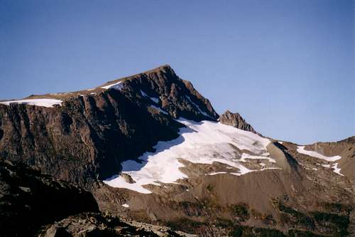 Mt Albert Edward Upper NE Ridge | 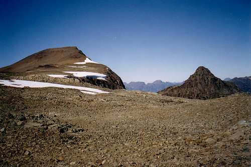 Upper NE Ridge of Mt Albert Edward |
 Route down from AE. Enlarge for details | 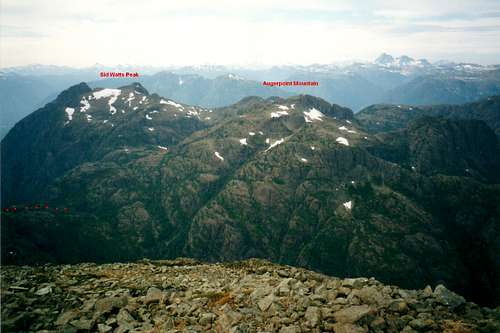 Syd Watts Peak and Augerpoint Mountain. Enlarge to see route. | 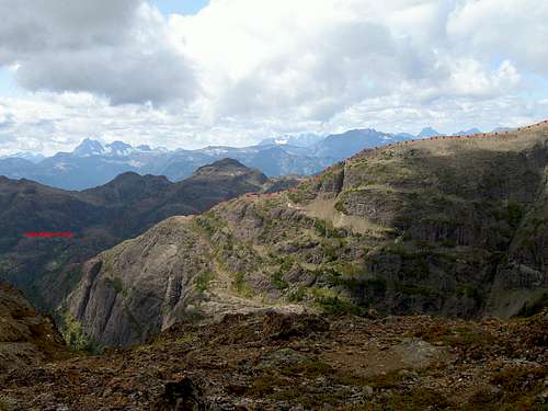 SE Aspect of the route. Enlarge for details. |
Day two
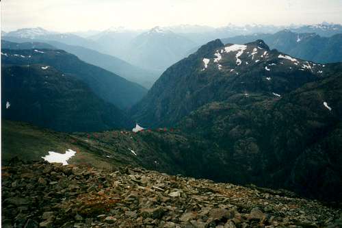
From the tarns above the drainage divide look for the route down onto the saddle on the left (south) side of the camping area. There may be a cairn marking the spot. Descend onto the divide and turn initially north (right) down a gravelly draw towards the headwaters of Norm Creek. Don’t go too far north. Watch for a few flags on the left hand (west) bank of the draw. At the flags turn west, go across a small slabby flat area and then further west down into old growth until you reach a flat area with a shallow seasonal tarn. Go south along the east bank of the tarn to its far end and back into the trees. The route now turns SW as you climb up towards Ruth Masters Lake. Depending on your choice of route, don’t worry if you find yourself confronted by some bluffs barring the way back into the alpine. This is the most difficult part of the route to navigate and a few folk have left flags or built cairns. Whichever way you choose, always trend SW until you can get out of the trees and see the waterfall below Ruth Masters Lake. Make a beeline for the waterfall; walk up past it and up to the shores of the lake.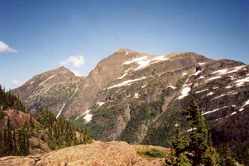 Mts Albert Edward and Regan | 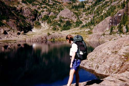 Ruth Masters Lake |
Day three
From the west end of Ruth Masters Lake climb the steep, relatively open slopes making a beeline for the obvious saddle at GR 216044 in the ridgeline connecting Augerpoint and Syd Watts. You should have noted this saddle from the summit of Albert Edward on day 1. There is no trail nor any route-marking that I have seen. There is, however, a good-sized cairn right in the centre of the col to show that you’ve taken the correct route. It should take about an hour from the lake. At the saddle drop the packs, turn right (north) and walk up Augerpoint Mountain – about 1-2 hours return – if you hadn’t already done so yesterday.Back at the packs turn left (south) and up to where the ridge flattens out and you can see it swing west then north and down to another saddle above Shark Lake. At the point where the ridge swings west, you have the option to drop the packs once more, continue south and bag Syd Watts Peak – 2 hours return. It’s all a question of time available.
Back at the packs once again, continue west along the lovely open ridge, descending slightly and then back up to the crest as the ridge swings north. Don’t worry if you can’t find the way on to the round crest of the ridge. It’s perfectly feasible to continue north on ledges on the east side of the ridge above Shark Lake if you don’t mind a little Class 3. If you do attain the round top of the ridge crest don’t be suckered by a nice looking trail heading down and west. This was the original Park’s Augerpoint Trail but now drops you right into an old burn area and a world of hurt. Instead go north and down to the saddle studded with ponds. Here you will again find a reassuring (and large) cairn to indicate that you’ve taken the correct route. It’s certainly feasible to camp here if time and inclination allow.
 Mt George V from GR 216044 | 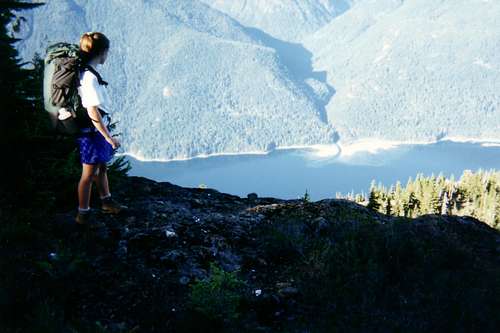 Buttle Lake | 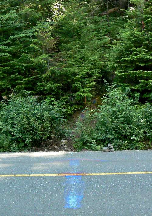 Augerpoint trailhead |
Shortly after starting downwards, still heading north at this point and as you enter the first trees, you will come across the first consistent trail marking you’ve seen since the first few hours of day 1 in the form of coloured blazes on trees. Follow these – and even a path in places – north across the face of Jacks Fell to a flat bench with tarns. You are now on “Jack’s Trail” a trail built by Jack Shark of the Comox and District Mountaineering Club (CDMC) as an alternate route to Augerpoint Mountain when Park’s original trail was destroyed by fire. At the tarns you’re looking down at Buttle Lake nearly 1000m below. The trail turns sharply left (west) and plummets down the 1000m of knee crunching descent through the forest to the road in about 2-3 hours. Take care on one or two open talus slopes.
There is no sign of the road until you’re within a minute or two of stepping out onto it. No flat walking separates the road from the steep mountainside you’ve just come down. You literally step off steep trail right onto the road. There is no trailhead, sign or anything of an official nature. Just a large red and blue arrow painted on the road surface pointing into the trees. If you’re working the two-car shuffle indicated above don’t leave your car at the arrow. There are cleared spots 100-200 m north of the trailhead but right on Westmin Road. If you'd rather your car was right off the road, the Augerpoint day use area/parking is 1 km south of the arrow. The arrow is 19.9 km from the bridge across Buttle Narrows where Highway 28 to Gold River and Westmin Road split.
It goes without saying that Augerpoint can also be climbed as an out and back trip from Buttle Lake. The trip length, however, is about the same and the through route at least lets you see more of this area of Strathcona Park.
Essential Gear
No technical gear but all the navigational tools you've got and can use. Also don't forget your preferred mobile bear and cougar proofing hardware to protect your food (and yourself).Red Tape
In the unlikely event that you decide to camp at Kwai or Circlet Lakes, or anywhere else in the designated core area of Strathcona Park, there is a $10/person/day fee. There is a self-registration box and payment slot at the Paradise Meadows trailhead. Payment can be by cash or cheque. I haven’t seen a stipulation specifying Canadian funds but I’m sure Parks wouldn’t refuse a cheque in US funds. Otherwise there is nothing to pay.Be aware that this is a tough trip into a remote area and that BC Parks does not operate an intentions system. Make sure, therefore, that you have left a detailed trip plan with someone responsible. Parks and the appropriate SAR agency will respond in an emergency but it is up to you to have the mechanism in place that will initiate the call-out process if it becomes necessary.
Camping
Camp in the areas described above. Fires are strictly prohibited, so you must pack a stove. Bear and cougar frequent the mountains and forests of Vancouver Island, so proper back country methods – hanging food bags out of reach, cleaning up all cooking scraps, good toilet practice etc – are essential. Giardia is well documented throughout Strathcona Park, so boil or treat all water.External Links
Strathcona Provincial ParkWeather on the east side of the route
Weather on the west side of the route
You can get a live view of what the weather's doing right now at the Paradise Meadows trail head from Mt Washington's webcam
Additional Information
The correct map is essential for this trip. Obtain a copy of the government topographical map sheet 92 F/11, “Forbidden Plateau”. Advance copies can be ordered at BC Government maps on-line. Copies are usually readily available in good bookstores and outdoor stores throughout the Island.Suggested Reading
Beyond Nootka – A Historical Perspective of Vancouver Island Mountains, Lindsay Elms, Misthorn Press, 1996, ISBN 0-919537-29-4 and/or visit Beyond NootkaIsland Alpine – A Guide to The Mountains of Strathcona Park and Vancouver Island, Philip Stone, Wild Isle Publications, 2003, ISBN 0-9680766-5-3 and/or visit Island Alpine Climbing Guide
whariwharangi - Sep 10, 2007 1:44 am - Hasn't voted
Ruth Masters Lake ApproachesThe stretch between Albert Edward's peak and Ruth Masters lake has some exposed and steep sections. The most difficult section is at the bottom between Augerpoint and Albert Edward. This section has some flagging and cairns that are really useful but the marking isn't consistent. There are areas where the route isn't very obvious and the way is steep and exposed. There really is only one way up or down over some obstacles. Allow lots of time for navigation. The west end of Ruth Masters lake appears as a wall of rock. The route up is found on the right side of the wall, whilst facing uphill, and is currently marked with flagging (Sept 07). Once you've gotten above the wall then you can make that beeline for the top. The start of the trail from the ponds down to Buttle Lake is marked with red crosses painted on the rocks.
vancouver islander - Sep 10, 2007 10:58 am - Hasn't voted
Re: Ruth Masters Lake ApproachesThanks for these very useful additions. Doesn't sound like much has changed since I was there last. I've heard that it's well travelled these days but it's a route where navigation skills need to be well to the fore. After you get down onto the drainage divide below Albert Edward's SW ridge you go roughly north down a gravel draw - a precursor to Norm Creek. When I did the traverse, there were lots of flags to indicate the left turn out of the draw and the continuation of the route to the west. This was the only part of the route that I would call "well-flagged" and it's critical. Is that abundant flagging still there? Thanks again for your very useful comments. Cheers, Martin