
-
 10018 Hits
-
 81.18% Score
-
 13 Votes
|
|
Mountain/Rock |
|---|---|
|
|
37.83697°N / 83.68484°W |
|
|
Powell |
|
|
Hiking |
|
|
Spring, Summer, Fall, Winter |
|
|
1310 ft / 399 m |
|
|
Overview
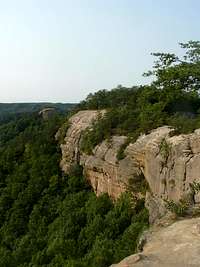
 Ridge in Red River Gorge
By CheesySciFi
Auxier Ridge is a small but scenic sandstone outcrop in the lovely Red River Gorge of Eastern Kentucky. Red River icons Ravens Rock, Double Arch, Haystack Rock and Courthouse Rock can all be seen from this perch.
Down the middle of the sandy ridge-top are stunted pines, but along the edges the bare rock provides for stunning, wide-open view. Auxier Ridge rises between the Auxier Branch to the west and the Fish Trap Branch to the east. Pack a lunch and come enjoy the view and maybe see some birds floating on the thermals overhead.
KY Rank: Unranked
Prominence: 60 feet
USGS Quad: Slade
Rank & Prominence: Lists of John
Photos Needed!
As you can probably tell, the photos on this page are old (15+ years) and electronic versions of scanned originals. Auxier Ridge is a fantastic and scenic part of Kentucky and the images I've included here do not do the area justice. If you have photos of this ridge and scenery from the summit that you'd like to share with the community, please attach your images to this page and send me a note (either via the comments or additions/corrects section of this page or an SP Private Message) and I will gladly integrate higher quality photos to this page. Thank you!
Getting There
View Larger Map
Auxier Ridge resides in the Red River Gorge area near Stanton, Kentucky. This area sits east of I-75 and south of I-64 in south-central Kentucky, roughly 25 miles southeast of Lexington, Kentucky.
From the I-64/I-75 split (south):
• Take I-64 east for 16.5 miles
• Take Exit 98 for the Combs Mountain Parkway
• Follow Combs Mountain Parkway for drive 32 miles
• Take Exit 33 (Hwy 15 - Slade)F
• At this exit, turn left then take an immediate right\
• Follow Hwy 15 for just over 3 miles
• Turn left onto Tunnel Ridge Road (bridge over parkway)
• Follow Tunnel Ridge Road for just under 4 miles to the Auxier Ridge trail parking area
Auxier Ridge can be reached via a 3.5 mile roundtrip hike on the Auxier Ridge trail.
Red Tape
 Bright autumn sunlight on Auxier Ridge
Haystack Rock is visible in the mid-ground center of the photo
 On the sandstone cliff-sides of Auxier Ridge
Auxier Ridge resides within the Red River Gorge Geological Area, a special designation in recognition of the unique sandstone formations including arches and cliffs. This area is part of the Daniel Boone National Forest. A summary of regulations:
• Backcountry permits are required for camping north of KY 15.
• Recreation passes are available at any Forest Service office and at many local vendors.
• Campfires are prohibited within 100 feet of cliff-faces.
• Vehicles must stick to established roadways.
• Some areas are closed to rock climbing and these include Sky Bridge, Gray’s Arch, Nada Tunney and the Chimney Rock Overlook.
• Buy campfire wood near the Gorge to avoid transporting tree-killing diseases and pests.
Camping
 View from Auxier Ridge
By CheesySciFi
Koomer Ridge Camground
• 54 sites for tents or trailers
• Both vault and flush toilets
• Bath house with showers
• Drinking water, grills and picnic tables
• First-come, first-served
Camping is prohibited in or near any picnic or parking area, within 300 feet of any roads or developed trails, within 100 feet of cliff-faces or rock shelters, within 600 feet of Gray’s Arch or in any area posted as “No Camping.”
Weather & Seasons
 Auxier Ridge in summer
By CheesySciFi
 Auxier Ridge in autumn
Spring: Spring is a pleasant time of year in this part of the country, colored in soft greens and tempered by warm breezes.
Summer: Summer in Red River Gorge is hot, humid and crowded.
Fall: Fall is an absolutely delightful time to visit the Red River Gorge, with cooler, dryer air and brightly colored leaves.
Winter: Expect cool to cold and damn conditions and ice may be a problem on trails, especially on exposed sandstone like that on Auxier Ridge.