Lead up
![Kaweah Range zoom from Little Five Lakes]() The ever-imposing Kaweahs from Little Five Lakes.
The ever-imposing Kaweahs from Little Five Lakes. I always wanted to climb Black Kaweah. I'd heard how after all these years, with all those Sierra hikers and climbers, that this peak, a "major" Sierra Peak, still had its original 1924 summit register. I like peaks where the easiest route is technical (i.e., 5th class). Black Kaweah's easiest route is 3rd class, but its remoteness (15 miles from the nearest trailhead) has the same outcome of making one earn its summit. But to be honest, the darn thing scared me. For one, the rock is supposed to be legendarily loose. For another, let's just say that "3rd class" routes with this little traffic in California tend to be a bit sandbagged. But most of all, the thing just looks like death! Some of the rangers at Lodgepole call it "Mordor".
But of course, when Robert proposed we climb Black Kaweah, I enthusiastically accepted. Still, I carried some angst with me to Bakersfield. For one, I hadn't climbed anything of note for a few years, so the thought of downclimbing 1500 feet of "California 3rd class" worried me. Of course, I might not even be able to make it to the base of the climb, since Houston is...well, topographically challenged. For the first time in my life, I actually trained for a climb on a stairmaster machine. It felt pathetic, and I was skeptical!
Getting Ugly Already
I took a late flight from Houston to Bakersfield, sleeping with the aid of 2 Benadryl tablets. I made it to Robert's place in Lodgepole by 3 am, though I was roused from my slumber at 7 so that we could drive to Mineral King to meet the other two climbers, whom I didn't know. The large number of climbers, coupled with my previous fears, gave me premonitions of bad things to come. I guess premonition is the wrong word--march a large group over a long distance and up a steep, loose climb and you're statistically fairly likely to have something go wrong.
Tim, Jacob, Robert, and I left the Mineral King trailhead at around noon on August 18, 2006. I quickly realized that in terms of conditioning, I was the weak link. We blazed up the 3300 feet climb to Glacier Pass in little more than an hour. From there, we descended to Spring Lake, at lunch, and marched up "Hands-and-Knees Pass", which drops into Big Five Lakes Basin. Both this pass's name and Secor's pessimistic description, made me a little uneasy. But we put our heads down and had reached the pass in less than an hour, with no "hands-and-knees" scrambling. In fact, having done all three crossings of the Great Western Divide in this area (Black Rock Pass and Sawtooth Pass are the other two), I believe that, "hands-down", "Hands-and-Knees Pass" is the best option.
At this point I was lagging the others and felt like crap! Little did I know, Jacob also felt like crap. By the time we started dropping into Little Five Lakes Basin, Jacob was behind me. By the time we reached the trail, he was way behind me. Little did we know, AMS had struck. By the time he reached us, he was barely moving and had started to puke. He stumbled down the trail to the Little Five Lakes ranger station and really began puking. Meanwhile, Robert ran to the ranger station to notify the ranger. Both Robert (NPS ranger with EMS training) and Tim (Emergency room physician) felt that Jacob's condition looked serious for AMS and might be morphing into HACE or HAPE. At that point, Robert called Lodgepole and requested a helicopter. However, by this time in the day it was too late for a chopper, so Tim and Robert decided that the best thing for Jacob was to make a beeline for the Big Arroyo Patrol Cabin, which stands at 9600 feet. So Jacob stoically marched 3 more miles, puking the whole way. Somehow he made it to our campsite without falling once, and collapsed into his sleeping bag. Within a couple hours, he felt much better. AMS is an odd thing. I wondered if the next day's climb would hold more suprises...
The Climb
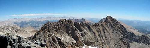
![Kaweah Range and Sierra Crest from Black Kaweah]() Summit Panorama--views of the Sierra Crest and Kaweah Range
Summit Panorama--views of the Sierra Crest and Kaweah RangeJacob decided not to climb Black Kaweah the following morning, so three of us started up the High Sierra Trail at 7:30 am. The climb out of Big Arroyo was more strenuous than we had bargained for, but we nontheless made pretty fast progress and were filling our water at the small tarns at 11800' at around 9:30. I was moving more slowly than the other two, and working up a real sweat. Being out of shape sucks! By 10, we reached the top of the "right-hand chute", where climbers traverse a couple hundred feet to join the deep gully of the Southwest Face route. I found myself immediately making technical moves up exposed, loose surfaces. 3rd class my ass! But this was a harbinger of things to come...
Robert marked our crossover point into the main gully with toilet paper. The gully was surprisingly smooth and weathered, presumably by water and ice erosion. The rock matrix was unexpectedly solid, inclined at 30-50 degrees, and more scalloped than your average Sierra granite. This made for much enjoyable 3rd class scrambling, though with death fall potential. Rockfall from above created the biggest hazard--talus on the route. Because the route is not a smooth incline, talus collects on benches.
By this time, I had not yet forgotten my "premonition". So as I ascended the aforementioned slabs, maybe this is why I backed down from an exposed spot as Tim climbed about 40 feet above me. It happened fast, but I saw Tim's foot dislodge a 20-pound rock. It slid, then bounced once, and I could see that it was going to be a close call. I just ducked my head like a turtle and closed my eyes...WHACK! Luckily the thing had not yet gone into a more ballistic trajectory, because it barely stunned me. But without a helmet, I might have gotten a broken nose, lacerations, or worse. Phew.
The route is fairly easy to follow. Other than local routefinding decisions (i.e., this crack or that slab?), there are only a couple perplexing decisions. One is where the West Ridge access gully joins the Southwest Face (stay right). The other occurs at around 13100', where you're faced with a 30-foot pitch of very steep climbing with death fall written all over it. In rock shoes, without a pack, and without the need to downclimb...maybe. But in this case, Tim found a nifty, if awkward, alternate path to the left, on the exposed spur of the gully. From here, it's another few hundred feet of sustained scrambling to the summit, an airy perch, but roomy enough for 3.
We arrived at 12:15 and immediately set out to sign the fantastic register and lingered in the perfect weather for 45 minutes or so. Unfortunately, we had to downclimb what we'd just ascended, and I wasn't looking forward to it. We went slowly and deliberately, knocking more than a few rocks down. Amazingly, we encountered a party of two--sans helmets--ascending at around 13000'. Apologizing for the rocks, we downclimbed past them and wished them luck. Funny to encounter another party on a route that sees perhaps 10 ascents/year. I realized just how hard this route was as I tried to reverse it. As a fairly large party, we chose to allow each climber to pass the nastiest sections one-at-a-time, but we were safely at the bottom by 2:30 or so. At this point, the adrenaline subsided, and I became cognizant of my rubbery legs and sore feet. My pace slowed to a crawl. Tim blazed back to camp to check on Jacob. Robert kindly stuck with me, and we didn't make it back to camp until 6. The return took me longer than the approach!
![]()
|
![]()
|
![]()
|
![]()
|
View of approach, up to the crossover between right-hand and left-hand chutes
|
Black Waterfall, as viewed from top of Right-hand Chute
|
View of crossover from Right-hand Chute to Left-hand Chute
|
Final 600 feet to the summit
|
Getting out
![Black Kaweah and Great Western Divide from Columbine Lake]() Spectacular alpenglow from campsite on Columbine Lake
Spectacular alpenglow from campsite on Columbine LakeIt's funny that when you're out of shape and hurting, your body doesn't feel better after another day of exertion. I guess it takes a week or so to feel some gains. So with my sore feet and legs, I somewhat dreaded the hike out. We decided to exit via Big Arroyo and Lost Canyon, mostly to explore a new area, but I secretly advocated this choice to avoid the amount of cross country we saw on the approach. Let me tell you now--the section of Big Arroyo below the patrol cabin is horrible! While the terrain is trivial, the trail is awful. Indistinct and swampy in late-August. It's probably 7 miles from the patrol cabin to the intersection with the Lost Canyon Trail. While fairly fast, this section, combined with forest fire smoke, sapped some energy. We should have followed Secor's suggestion to climb into Big Five Lakes basin via Little Five Lakes Basin, then over to the Lost Canyon trail.
The other problem with going down Big Arroyo is that you lose elevation--a lot of it. The trail drops to 7900 feet. Sawtooth Pass, another 8 miles away, is at 11700 feet. Ugh! We trudged uphill into Lost Canyon, through the smoke and mosquitoes, making good time, but never quite making up for our late start that morning. Jacob and Tim were about a half hour ahead at this point, wanting to make a beeline for Fresno. I felt good at the base of the big climb below Columbine Lake. I felt bad at the top of the climb! So I implored Robert to stop and camp. Good choice--we had the best campsite of the trip. Great alpenglow, great views, and great conversation, aided by the whiskey we'd brought. The last several miles to Mineral King the next morning went quickly, and before long we were baking in the 100-degree heat of the Sierra Foothills. Why was I in a rush to get out?


Comments
Post a Comment