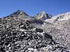
| The Setup An easy day in the mountains is always welcome, especially while on vacation. A last-minute change in plans required an alternate Labor-Day 2004 getaway destination, and I suggested the Rock Creek area as an ideal location for car camping. Fortunately, my friend Rob agreed, and our two families headed out for the high-altitude paradise. Even though the trip was designed for relaxation, Rob had indicated a desire to take a peak-oriented dayhike. My feet were still bothering me from a hike the previous Monday up Mt. Ritter and Banner Peak (during which an ill-fitting pair of shoes had removed more than their fair share of skin), but the opportunity to hike around the Rock Creek area was just too good to pass up. After a couple nights spent at 9,000 feet, we were feeling pretty good. As interesting peaks go, Bear Creek Spire certainly makes the short list in the Sierra. Exposed summit blocks, huge faces, 4th class minimum, and high-quality Sierra granite promised to keep things exciting. With a high-altitude start and a flat, freeway warm-up, the tall 13,713-foot summit was the icing on the cake. Some checking on SummitPost.org provided some nice tips and visuals of routes, and given the information I elected to attempt the class 4 Northeast Ridge/Face route --- a classic. Rob had been on one hike with me before, up Cleaver Peak on the Sawtooth Ridge, and there had showed willingness and ability to climb class 4 unroped if necessary. Unfortunately, holiday timing and my non-committal to do the hike prevented my veteran climbing partner Barry Beck from attending the party. I elected to wear some Teva sandals that I had procured for $10 at a recent Sierra Trading Post "blow-out" sale, along with a Camelbak Ares pack from the same. The sandals didn't contact the raw spots on my still-recovering feet, plus they needed breaking-in. My La Sportiva Exum Ridge approach shoes came along as passengers, but I wanted to leave them off as long as possible. I had accidentally left my Pur water filter at Barry's house the week before, so I ended up packing a full 100oz bladder along with an extra 32oz Gatorade. I lent Rob my Mountainsmith Wraith pack and he managed to fill it with plenty of water and layers as well. The Approach No matter the destination, hiking in the Rock Creek area should never disappoint. Sweet trails, scenic lakes, jagged ridges, soaring peaks, and wandering tourists abound. We left the Mosquito Flat trailhead at a comfortable 0845, and proceeded at a leisurely pace towards Morgan Pass. "California Alpine Start" not withstanding, the air remained cool and refreshing as we passed lake after lake after lake. After an hour-fifteen or so, we were nearing Morgan Pass, so I started looking for a convenient route towards BCS. I had heard about the use trail to Treasure Lakes, but I was also interested in the route past Pyramid Peak. We ended up taking a faint use trail to Gem Lakes and then started cross-country heading south. After scrambling along a talus rib for a ways, we traversed southwest onto the slopes of Pyramid Peak. The ledges along the north slopes were fast and easy, but soon we were rounding the corner to the steep, loose, west slopes. This was annoying, as I still had my Tevas on, so we dropped down to the 12,200' level into the bowl between BCS and Pyramid. As we were traversing across the west slope of Pyramid, I could see two figures on the summit of BCS, with another party about a third of the way up the NE Ridge. I toyed with the idea of cruising up Pyramid to sign in, but that would have meant putting my shoes on for the descent, and also would have distracted us from the real goal. I figured Rob didn't need the extra expenditure of the probable hour-long detour. Besides, California Alpine Starts don't come with extra daylight. |
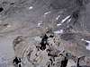
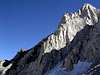
| The NE Ridge/Face A little more scrambling up large talus and ledges brought us to the base of the route. We had used up a fair chunk of time at this point, with the clock indicating 1300 or thereabouts. While that still gave us plenty of time for the ascent, if significant difficulty was encountered we would need lots of time to reverse it all. I could see the party ahead making very slow progress up the route, and I started to wonder if they were all roped up… We kept a slow-but-steady pace up the class 2-3 to the first tower, which I passed on the left. More tower blocked the way. It appeared that there was a point where lots of traffic crossed over to the north side of the ridge (on dark-colored rock) down to a ledge for a short chimney ascent, but things looked pretty steep over there. As I cruised up a series of vertically-oriented weathered cracks (light-colored rock) on the south side of the ridge, I noticed an orange rappel sling slightly below me. A little scouting found an exposed class 3+ ledge around a corner to bypass the gendarmes, and we were on our way again. This time I stayed either on the crest or else slightly to the right until it was obvious we were getting close to the wall of the North Arête. Looking over at the face, I could see that it held numerous sandy ledges that would make a traverse there easy. The problem was figuring out where to gain the summit ridge. I started left into a sandy gully and worked up to the headwall of the North Arête. There I found two members of the party of three that I had been observing since the slope on Pyramid. They were roped, and were belaying their lead straight up for the arête. I asked how they were doing, and they said they were heading back as it was late. I joked that we were about to our turn-around time too, and asked if they were going to hit the arête for a little extra fun. They said no, "there was no turning around on this route," and added that they needed to get back to Mosquito Flat TR that evening. A little confused, I bid them a safe climb and continued. They had given me a funny look, and then I realized that my Tevas did contrast with their rock shoes. At that point, Rob and I stayed level on some more sandy ledges, and followed the line to a 4th-looking section just below a huge sharp overhanging gendarme on the summit ridge just left (south) of the summit block itself. I had seen an occasional track in the sand below, and I hoped that the final pitch would be easily reversible if needed. Up to this point, I had told Rob to only do things that he felt he could reverse without incident, as I did not know what to expect on the west side of the peak. My Tevas had helped me stay in check as well, and our slow pace had allowed me to scout and make careful route-finding decisions. The final 30 feet or so proved to be real class 4, as one transition move out of an off-width felt downright insecure in sandals. This line had brought us to the crest directly between the huge tooth-like overhanging gendarme and the summit block. |
| At the Top! We did the exposed traverse over a 5-foot gendarme to the north side of the summit, where I weighed the final move to the top. It didn't look so hard, but the first handhold on the top of the block would be all friction. Having come the entire way on Tevas, I made the stupid decision to finish it that way. After checking the holds, I high-stepped to the little dish on the right and moved for the top --- and suddenly there was water spraying everywhere! My Camelbak hose had scraped along the rock as I did the roll, and the little yellow switch on the valve just popped away down the face. It was a shock, but that was not the time to screw around. I finished the roll, found the nice incut near the high point, got the left leg across the block, and sat there as if perched in the saddle reviewing the damage. There was no wind, no air movement, not a cloud in the sky. Things seemed pretty exposed right there (although nothing like Starlight!), so I didn't dwell on the airiness. I ended up taking the shut-off valve out of line and putting the drippy bite valve directly on the Camelbak hose. Then, I gingerly replaced the Tevas with my approach tennies for the descent while the water on the holds dried out. Thus shod, I was able to reverse the block without difficulty. Rob was busy changing into his rock shoes at this point, so my delay didn't screw things up too badly. He went ahead and tagged the summit with his hands, which was enough, and then we signed in. As we prepared to depart, I noticed the lead of the party of three slowly working up the exposed arête about 100 yards away. As it was nearing 1545, I was anxious to see what sort of descent route awaited. I was not particularly interested in reversing the NE Ridge, given the time that it would take, so I was quite pleased to see that the sandy ledges of the Ulrichs Route were only 40 vertical feet away. Recalling to mind the photo posted by Bob Burd on SummitPost, I headed north along the very cool exposed crest for maybe 60 feet. There I found a point where a two-move hop down brought me to a nice flake/ledge that doubled back about 20 feet to a short corner/crack system that would obviously take us to safety. We down-climbed this short section without incident and were home free! |
| The Return After picking our way down the slippery Ulrichs Route, we made it to Cox Col and found the easy exit about 200 feet uphill to the north of the Col proper. At this point, I could see the climbers still on the arête, and I hoped that they were going to summit, as they were getting very close. After the class 2-3 sandy ledges down, we skirted the minimal ice left on what used to be the north glacier, and began the long slab-and-talus work to reach Dade Lake. As we got the last view of the west face of BCS, I could see the climbers rappelling off the arête to the Ulrichs Route, not having summited. Soon we were looking for an easy way to get to Treasure Lakes. There were two hikers doing the same as we arrived at the saddle next to Dade Lake. I considered staying on the slabs of the ridge to the right, but all the traffic seemed to go down to the large talus fields in the bottom of the valley. Since I was more interested in finding the fabled use trail, I stayed with the masses and went talus hopping. The other hikers followed suit, and thankfully did not shower us with rocks during the initial steep section. The talus went on past Treasure Lakes, and continued right down to the 10,700' level, where the trail solidified, skirted a scenic meadow, and headed down a gentle gully to Long Lake and the main trail. There we halted while I changed back to Tevas, and drank the last of my 100oz reservoir. By now it was 1745, with an hour or two until dark, so we took our time getting back to the trailhead and the drive to camp. All in all, it was one excellent day. Being able to camp near the trailhead and not drive for very long either before or after was nice, along with the 10,000'+ start. The trail and approach navigation was pretty straightforward, with the Treasure Lakes route being slightly more agreeable than the Pyramid Peak approach. Practically the entire trip was on solid talus or ledges, with very few annoying spots. The NE Ridge/Face was challenging and exciting, with strong class 4 sections. The descent via Cox Col is fast, easy, and fun. Given the quality of the routes and the minimal elevation gain overall, this rates as one of the more enjoyable dayhikes I've done yet.
|


Comments
Post a Comment