
-
 3134 Hits
-
 75.81% Score
-
 6 Votes
|
|
Route |
|---|---|
|
|
36.47140°N / 109.0003°W |
|
|
Hiking |
|
|
Summer, Fall |
|
|
Less than two hours |
|
|
Class 2 |
|
|
Getting There

I followed directions given by Jobe Wymore to approach Beautiful Mountain from the east. Following are those directions:
“Drove south from Shiprock for a while until I got to the turnoff that leads to Sanostee on the right (BIA 34). From the far end of town (west side) on the main drag (34) the road will make a hard left and immediately after that you will see a dirt road that extends to your right marked N34. Dirt road and it is a washboard. Turn right on this road and just head west. At 1.3 miles you'll pass a small little suburb of Sanostee and at 2.5 miles it goes over one wash and another at 3.3. At around 4.7 you reach a marked junction with 5013. Hit the odometer at this point again.
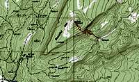

The next few miles the road gets a little bit bumpier and I'm not sure if a car could make it without high clearance. At 4.7 miles on this road (5013) it tops out and starts a gradual decent. At 5.5 miles keep a close eye out for a smaller road that appears on your right. Turn here and hit the odometer again to clear it. Immediately after taking the right turn you'll see some sort of a small stone structure on your left. Continue up this small road that actually wraps around the south end of Beautiful Mountain. This is a non-maintained section. Hasn't seen work in a long time I'm sure and you can tell. There are sections where the road is at such a side angle you get the feeling (at least I did) that rolling is not out of the question. 4WD is mandatory. At 1.1 miles up it there was a fallen tree over the road that was passable if you drove through some brush on the right. At 1.8 the road "Y's." Stay left here and roughly around 2.6 miles park on the right side of the road in a place that has nice shade for your vehicle.”
Notes: 1. Jobe used Highway 491 southward from Shiprock. 2. The tree on the last section has been removed. 3. 4WD is a very good idea, but I didn’t feel like my rig was going to roll over. 4. Elevation at the trailhead is about 8,300 ft.
Route Description


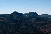
This route is not technical although other routes could be very technical rock climbs. Once you get to the trailhead, most of the route finding is done. On the drive in you should have noticed the vertical rock walls on your left or west of the last part of the road. The summit of Beautiful Mountain is above the vertical walls. At the trailhead you cannot see the vertical walls.
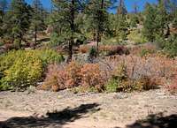
There is no trail to the summit of Beautiful Mountain. From the parking area at the trailhead, go northwest up the brushy slope on the other side of the road. There are some steep open scree areas that give you access up the slope. You need to climb about 250 ft up to the top of the first ridge. On top of this ridge you will be able to see the vertical walls protecting the summit. Look closely ahead and you will see a scree/talus brushy ramp ascending into a notch in the vertical walls. You can’t see the entire slot, but this ramp leads up to the top of the vertical walls. Pick and chose your route through the forest, brush, and rocks towards this ramp. It is easier if you aim for the far right hand wall that forms the slot. As you get close to the right hand wall, you should be able to find a dry streambed/game trail in the middle of the ramp. Follow this streambed/game trail westward as a stairway to the top of the vertical walls. This ramp is steep, rocky, and brushy but it is not technical.
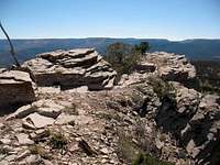
You will top out on this slot at about 9,000 ft where you will be on top of the vertical walls. Look around and note where you are so that you will be able to find this spot when you come down. Once on top, turn again northwest towards the rocky summit that you may be able to see about 400 ft higher through the brush and trees. The slope up to the summit is kind of brushy, but I found by going a little to the right you are more in a forest area and out of the brush. The summit is nice and open and the views are great. Return to the trailhead the same way you came up. A GPS may be handy to help with that chore.
Total hike was only 1.65 miles, gained 1,030 ft, and took 1.75 hours.
Essential Gear
The 10 essentials are always required. There is no water on the trail, so take all you need. A GPS may be handy depending on your navigation skills.