Four Miles of Bad Road
During the last couple of miles of driving before the Shepherd Pass Trailhead, I slowed way down and held my breath as I maneuvered my low clearance vehicle over high clearance terrain. Unlike a couple of years ago driving to this same trailhead, this time I arrived with my car’s oil pan intact. At early evening, biting black flies were there to greet me, but otherwise conditions were great at the trailhead. I got a good night’s sleep inside my van soothed by the sound of nearby Symmes Creek.
A TRIP DEDICATED TO PATTY RAMBERT
Saturday morning, June 3, our group of five lifted our packs and headed out for Anvil Camp. Our goal was Mt. Williamson (14,375 ft.) on Sunday. All of us knew Patty Rambert, who was killed in a fall on Mt. Mendel on May 31, 2006, and it was a given that we dedicate our trip to her. A trip like ours was a mainstay with Patty. The mountaineering community was greatly diminished by the loss of such a charismatic, dedicated and caring outdoorswoman.
Shepherd Pass Trailhead to Anvil Camp
![En Route to Anvil Camp]() View in Shepherd Creek drainage en route to Anvil Camp Jun 3, 2006
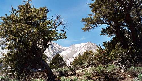
View in Shepherd Creek drainage en route to Anvil Camp Jun 3, 2006![Symmes Saddle]() View toward Mt. Williamson from Symmes Saddle June 3, 2006
View toward Mt. Williamson from Symmes Saddle June 3, 2006For about the first mile, the trail follows Symmes Creek in a westerly direction and requires four stream crossings. At the first crossing, all the rocks were submerged, so several in our party elected to take off their boots to cross. At the other three crossings, the creek was running strong but there were rocks and logs in strategic locations to get you across.
You gain about 2,800 feet in less than 3 miles from the trailhead. At Symmes Saddle, you get a spectacular view of the north face of Mt. Williamson. At that point, the trail begins losing about 575 of hard-earned feet as it descends (you hit a second saddle on the way) into the canyon of Shepherd Creek. From the lowest point of this section of trail, it’ll be another 1,800 feet of gain to Anvil Camp.
When we arrived at Anvil Camp (10,040 ft. elev.), we found lots of snow interspersed with dry areas. We selected one of the dry areas for our camp and pitched our tents. That evening, a couple of climbers stumbled into our area. Earlier in the day, they had been unsuccessful in summiting Mt. Williamson because they had taken a wrong chute on their way up the West Face.
Big Horn Sheep and Mule Deer at Shepherd Pass
![Mule Deer at Shepherd Pass]() A Mule Deer bounding up Shepherd's Pass June 4, 2006
A Mule Deer bounding up Shepherd's Pass June 4, 2006![Shepherd Pass, Sierra Nevada]() Shepherd Pass
Shepherd PassThe next day, we got moving a little after 5 a.m. We started out with crampons on the hard morning snow, but soon got to snow cover we could travel safely on with our boots. We alternated between sections of boulder hopping and sections of snow. When Shepherd Pass came into view, we were treated to the sight of 7 Big Horn Sheep zig-zagging towards the top of the pass. When we got to the base of the pass, we simply followed the tracks left by the big horn. Nearing the top of the pass, we got another wildlife treat when 2 mule deer scrambled up just 100 meters to our right (see primary image and photo to left). Never knew that deer had any reason to go as high as 12,000 feet!
Moving on from Shepherd Pass, Mt. Tyndall loomed to our right as we headed into Williamson Bowl. Soon, Williamson’s West Face was staring right at us. Mindful of the two that had gone up the wrong chute yesterday, we began eyeing the face to pinpoint the black stain that is a reference point in all the route descriptions. We spotted our route. It would go to the right of the black stain. The stain was actually sitting right under a waterfall. We maneuvered around the lakes in the bowl and finally got to the base of this majestic mountain.
A Tiring Chute and a Fun Chimney
Early in the ascent, we stopped to fill up our water bottles and bladders at the waterfall running over the stain. Starting up the large 1,500 foot chute (this chute runs diagonally up and to the left across the West Face), we had a choice: rock or snow. We opted for rock and scrambled up on boulders and lots of annoying scree to the right of the snow that filled the chute.
The top of the chute is blocked by a massive wall. An obvious passage to the right avoids this wall and takes you to the 100 foot Class 3 chimney. This chimney is by far the most enjoyable climbing on the route. Some parts of this chimney definitely felt like Class 4 and some of our group felt better with a belay. At the top of the chimney is the summit plateau. At this point, what is called the West Horn is directly in front of you across a plateau. Williamson’s summit is to the right about 500 feet. We reached the summit at about 2:30 p.m. At 14,375 feet, there was good cell phone reception and I called my wife in South Pasadena to assure her that I was still intact.
Stumbling Back to Camp
On the descent, the fun of downclimbing the chimney passed all too quickly. When we reached the big chute, we this time opted to go down the snow. It was a good choice. The snow was soft and it was immeasurably more enjoyable plunge-stepping down the chute at a fast clip, than it would have been sliding down scree pockets on the side.
After getting back across the bowl, the drop into Shepherd Pass was probably the diciest terrain we had to negotiate all day because of the short sections of icy spots we had to get by. We had been concerned about losing our daylight with an icy Shepherd’s Pass to descend. Luck was with us on both accounts: the snow was still soft when we reached the top of the pass and the lights did not go out on the day until just the time we reached the bottom of the pass. Again, we were able to plunge-step briskly down the slope.
Route finding back to camp was a little bit of a challenge in the dark and on snow-covered terrain. Even intermittent post-holing tested our ever fading energy as we closed in on a 16 and ½ hour day. Our leader, Alex, did a great job of navigating coupled with GPS back-up. We stumbled into camp a little after 9:30 p.m. and in no time were gorging on Trader Joe delicacies to refill the carb and fat reservoirs emptied by the day’s work.


Comments
Post a Comment