
-
 5621 Hits
-
 72.08% Score
-
 2 Votes
|
|
Route |
|---|---|
|
|
51.46390°N / 116.3306°W |
|
|
Mountaineering |
|
|
Summer |
|
|
Most of a day |
|
|
Difficult Scramble |
|
|
Approach
This is a 3800’+/- ascent day. Unlike most objectives in the Canadian Rockies, you can actually see the summit block of Mount Bosworth from the road. The summit is darker than the other rock on the ridge and is clearly marked via the “red lined route” photo on the main page. There is no trail.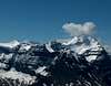 | 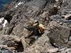 | 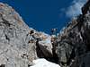 | 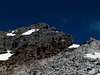 |  |
Route Description
You immediately ascend an avalanche gully and angle over to your right into a broad drainage. Stay to the left for better ground here and eventually cross this drainage as it narrows and continue to ascend via a water worn rock feature (gully). This is a good spot for your helmets due to loose rock, particularly if not solo. Ascend the right side of this waterfall-drainage-gully until you top out onto a scree/snow slope. Staying in the middle of this slope affords you decent ground, firmer than the snow to the left and/or scree to the right. Ascend angling left so you can overtake the skyline sharp ridge on your left. Ascend this next gully angling left when possible, looking for grassy slopes and firm rock to ascend versus the scree. Again, you are looking to traverse into the next gully left (west) underneath a rock face. There is a great lunch spot at about 8200’ below this rock face that not only offers superior views of Mt. Victoria and Cathedral Mountain to the southwest, but also allows you to study the remaining route to the east ridge of Mount Bosworth.You will notice, if early enough in the season, a snow slope that leads to the left. Just right of that slope is a narrow rock problem that is more enjoyable of a climb. Climb to the left of a large boulder that serves as a head to this narrow gully and continue northwest to gain the eastern ridge right below the summit block. This last 100’+ is the crux of the climb. You must pick you way through a maze of loose rock bands to the summit. As stated on the main page, the views from Mount Bosworth, for a 9000’ mountain, are unparalleled in the Canadian Rockies due to the convergence of five separate valleys. Included are the north ridge route of Mt. Victoria, the north glacier of Mt. Temple, Mt. Niblock, Mt. Whyte, Popes Peak, Mt.St. Piran, Narao Peak, Mt. Collier, The Goodsirs, Odaray Mountain, Mt. Vaux, Cathedral Crags, Mt. Stephen, Mt. Carnarvon, The President and Vice President Mts. Daly and Niles, Paget Peak, the Bath Glacier, south end of the Wapta Icefield, Mt. Hector, Redoubt Mountain, Mt. Richardson, Pika and Ptarmigan Peaks and many more.
On ascent of that summit block you can spread out and attack different routes. As well on descent, it is imperative that you not climb on each other. Bosworth’s east ridge is incredibly loose, but not unusual for the Canadian Rockies. Once back down that tricky 100’, catch the snow glissade straight down at least 1000’ before making your traverse left aiming for a “dragons back” buttress section sticking out south from the slopes. There is a considerable water worn cliff below if you continue down the drainage immediately below the summit. You must traverse back to your ascent route which is just on the east side of the before mentioned buttress. If fact in June, we used more snow at that section to lose another 600’ or so on glissade. Return as you ascended making sure not to stray too far left. And again, you must stick close together or far apart through the water worn drainage area to avoid rock fall.