
|
|
Canyon |
|---|---|
|
|
40.30000°N / 108.98°W |
|
|
Overview
Buckwater Draw is a fantastic technical slot canyon in NW Colorado. The entire drainage is known as Buckwater Draw, Magic Chamber is the name of the slot section within the drainage. Slot canyons are canyons that are narrower than they are deep. This canyon is so narrow, you are able to touch both sides with your hands in several sections. Utah and Arizona are well known for slot canyons, but Colorado's slot canyons remain a secret and are very seldom visited. Those who climb only mountains are missing out. This slot canyon is a nice change of pace from the normal climbs of the 14'ers in Colorado. This canyon is very similar to those found in the Escalante or Robbers Roost areas of Utah. This slot canyon is in a very pristine area and until now has not been in any guidebook or website, so please do your part to keep the canyon pristine. Enjoy!Note: This page describes the Main Fork of Buckwater Draw. Click HERE to view the page on the South Fork.
 Inside the Magic Chamber.
Getting There
"Old Route" TrailheadTo get to the trailhead drive to the park headquarters of Dinosaur N.M., which is a few miles east of the town of Dinosaur, CO (Dinosaur is located on Highway 40 just east of the Utah border). Drive north on the Harpers Corner Road for 6.9 miles and park on a little side track on the left. This canyon is in a WSA and the BLM request that you park just inside the gate.
"Plug Hat" trailhead
From the visitor center, drive north along the Hapers Corner Road for 4.2 miles to the Plug Hat Picnic Area. Park here.
 This is the top of what I call the Magic Chamber in the Main Fork of Buckwater Draw.
Routes Overview
There are several route possibilities available. All routes require competency of at least 5.7 climbing.Old Route
To just see the main fork and return via the old route, see the Main Fork Route Page. Briefly put (see the route page for more details): From the trailhead, the route follows the old road until the drainage to the south is starts to deepen. The route then follows the drainage until you reach the beginning of the slot. There are several downclimbs of up to 5.7 in difficulty and the slot gets better and better as you continue down canyon. The canyon is incredibly twisty and there are fantastic erosion features. You may get your feet wet in some pools. The highest rappel is 95 feet and is in the best section of the canyon. There are chockstones and logs wedged almost 100 feet above the canyon floor in the slot. When the canyon opens up and becomes very shallow, the route climbs north and back on to the old jeep road which is followed back to the car. There is about 1800 feet of elevation gain and the jeep trail is very steep, so expect a workout. Expect the route to take 6-9 hours depending on the experience of the group.
Other Routes
There are several other alternate routes available. The "old route" is the original route we took, but later we found that it was less effort to come in from Plug Hat Rock, especially if you want to see both forks. You can also go down the "Old Route" and exit via Plug Hat.
Plug Hat Exit Route
If a car shuttle is available you can do the slot and return via the Alternate Exit Route to Plug Hat Rock (see the route page for details). This is less effort than hiking out to the "Old Route" trailhead.
Grand Tour
If you're up to it and want more you can do both forks of Buckwater in one shot. See the Grand Tour of Buckwater route page for more details. This is highly recommended.
You can either do the “old route” down in and exit via Plug Hat Rock, or you can do the "Grand Tour" round trip from Plug Hat Rock. This is now the recommended route and requires no car shuttle.
Note:
If time is limited, I feel that the South Fork is the better of the two canyons (Main and South). Here is the recommendation for a quicker look at the best parts of the two Buckwater Draws: Park at Plug Hat Rock. Complete the South Fork to the confluence of the Main Fork. Go up the Main Fork and see the Magic Chamber and the falls. Hike back to the confluence and go down Buckwater to the exit on the South Side. Climb out and back to Plug Hat. You will see the best sections of both canyons (both the Main and South Fork). Unfortuantely, you will also miss the really nice rappel into the Magic Chamber, which is also worth doing if you have the time.
The best sections of the canyon system are as follows:
The South Fork Slot, the Magic Chamber, the deep section of the canyon after the confluence of the two forks, and the rap into the Magic Chamber.
 Wall detail in the lower canyon.
Clean Canyoneering Ethics
The canyons in this area are very pristine. Bolts are not needed to descend this canyon, and would detract from the incredibly pristine setting of this slot canyon. We saw no signs of previous descent in June of 2003. Please keep it that way. There are plenty of chockstones to wrap slings around for anchors. It would be best to use a retrievable sling system, but if you don't have any experience with this, leave the sling behind at every drop. Try to leave as little behind as possible. This slot is not for beginners; canyoneering techniques must be practiced before going on this trip. Rap into the chamber.
Red Tape
There are no permits required.When To Climb
The Echo Park road opens in late April in most years. The best times to do this trip are late April, May, early June, September, and October. The trip can be done in summer, but can be very hot. Take lots of water. DO NOT ENTER THIS SLOT CANYON WHEN THERE IS A CHANCE OF RAIN. Flash floods can make slot canyons deadly.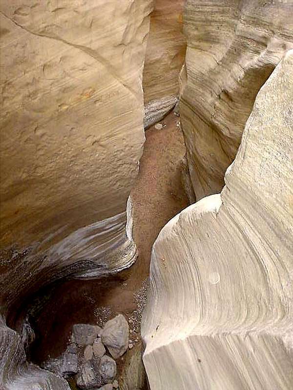 Twisty Narrows in June.
Equipment Needed
Several slings (bring 60 feet minimum), 6-10 rapid links or rappel rings, one 60 meter rope, one 15 meter rope, and a climbing harness. There may be short wades in the slot, but probably never any swimming, so go prepared for that. First rap.
 Camping
There is a campground at Echo Park in Dinosaur National Monument. There are other campgrounds located to the west and near the Dinosaur Quarry Visitor Center. For more information call the park headquarters at 801-789-2115. There are also informal campsites on BLM land along Hwy 40.Mountain Conditions
For weather conditions and road conditions on the Harpers Corner Road call the Dinosaur National Monument Headquarters at 801-789-2115 or the BLM White River Field Office in Meeker at 970-878-3601, or see the website BLM.WEATHER FORECAST
Weather and climate data for the Dinosaur Quarry is below. *National Weather Service Data 1958-2004.
| MONTH | AVE HIGH | AVE LOW | REC HIGH | REC LOW | AVE PRECIP (in) |
| JAN | 30 | 4 | 60 | -39 | .51 |
| FEB | 39 | 11 | 66 | -40 | .62 |
| MAR | 54 | 24 | 85 | -13 | .65 |
| APR | 65 | 33 | 89 | 10 | .78 |
| MAY | 77 | 41 | 103 | 20 | .86 |
| JUN | 88 | 49 | 105 | 30 | .61 |
| JUL | 95 | 55 | 110 | 38 | .62 |
| AUG | 92 | 53 | 106 | 35 | .64 |
| SEP | 82 | 44 | 103 | 20 | .98 |
| OCT | 67 | 32 | 93 | 2 | 1.06 |
| NOV | 49 | 22 | 74 | -10 | .60 |
| DEC | 35 | 10 | 61 | -33 | .56 |