
|
|
Mountain/Rock |
|---|---|
|
|
45.81983°N / 10.65174°E |
|
|
Hiking, Skiing |
|
|
Spring, Summer, Fall, Winter |
|
|
6217 ft / 1895 m |
|
|
Overview
Cima Avez 1895 m is a massive mountain belonging to the Prealpi Bresciane e Gardesane and located in the Cima Avez chain, a ridge running between Bocca Lorina and Passo Tremalzo and bounded by the Valle di S. Michele and Val Lorina. More precisely, Cima Avez is situated between the Bocca di Selvareonda and Passo di Cap. To the West, in the direction of the Val Lorina (Trentino), the mountain shows large bastions of stratified limestone rocks, while in the side of the Valle Prà di Lavino the slopes are gently angled. It is just here on this side where it passes the Normal route, completely free of technical difficulties, but interesting as it follows a broad gravel road mostly built by the italian army during the WWI. At that time this mountainous area was crossed by the border between the Kingdom of Italy and the Austro-Hungarian Empire. The route is known also by the mountain bikers and it is also well passable with snowshoes in winter when the snow is consistent.
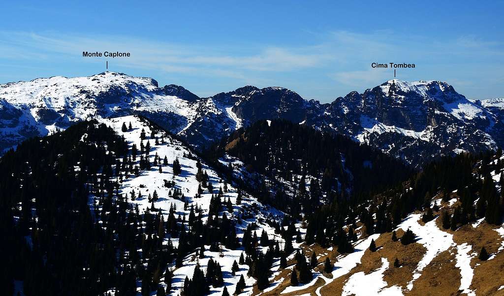
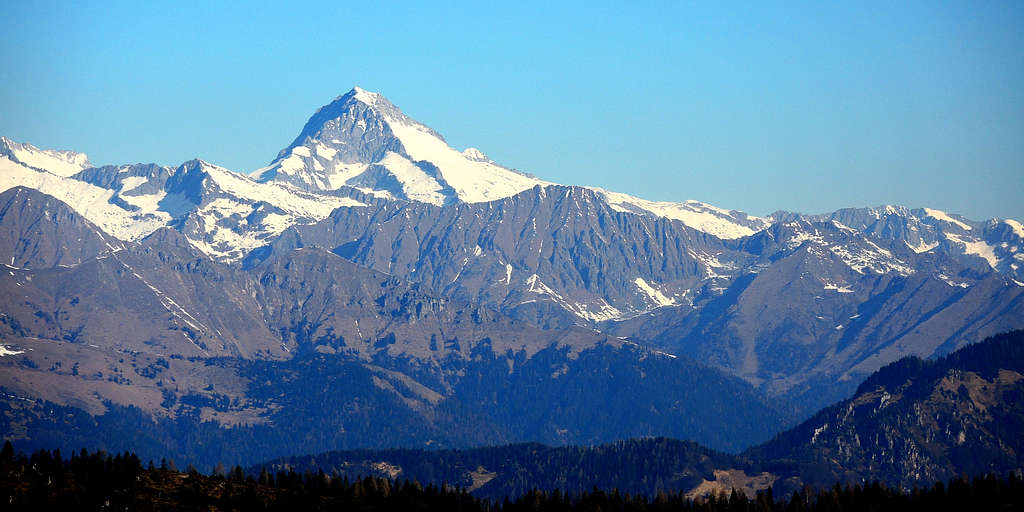
Thanks to its border position, Cima Avez gives wonderful views of the Trentino and the Bresciano and Lago di Garda. Moreover the summit offers a broad and interesting panorama over the distant glaciers of Adamello with the magnificent Carè Alto just in front and Presanella to the NW. At a shorter distance we see several mountain belonging to Ledro Alps with Monte Cadria, the highest one, Monte Caplone and Cima Tombea. Further to the right we see the profiles of the Brenta Dolomites and closer to the north-east Corno della Marogna and Monte Tremalzo. It seems that the toponym Avez derives from the word of the local dialect "aves", meaning "silver fir".
Italian version
Cima Avez 1895 m è una montagna imponente appartenente alle Prealpi Bresciane e Gardesane, catena di Cima Avez, dorsale che corre tra Bocca Lorina e Passo Tremalzo e delimitata dalla Valle di S. Michele e dalla Val Lorina. Più precisamente, Cima Avez è situata tra la Bocca di Selvareonda e il Passo di Cap. Ad Ovest, in direzione della Val Lorina (Trentino), la montagna mostra grandi bastionate di rocce calcaree stratificate, mentre sul lato della Valle Prà di Lavino i pendii sono leggermente più dolci. È proprio da questa parte che passa la via Normale, completamente priva di difficoltà tecniche, ma interessante dal punto di vista ambientale e storico, in quanto segue un'ampia strada sterrata costruita dall'esercito italiano durante la Prima Guerra Mondiale. All'epoca questa area montuosa era attraversata dal confine tra il Regno d'Italia e l'Impero Austro-ungarico. Il percorso è conosciuto anche dagli appassionati di mountain bike ed è anche ben percorribile con le racchette da neve in inverno, quando la neve è generalmente assestata.
Grazie alla sua posizione di confine, Cima Avez regala splendide viste sul Trentino, sul Bresciano e sul Lago di Garda. Inoltre la vetta offre un panorama ampio e interessante sui lontani ghiacciai dell'Adamello con il magnifico Carè Alto proprio di fronte e la Presanella a Nord-Ovest. A breve distanza vediamo diverse montagne appartenenti alle Alpi di Ledro con il Monte Cadria, il più alto, il Monte Caplone e la Cima Tombea. Più a destra vediamo i profili delle Dolomiti di Brenta e più vicini al Nord-Est del Corno della Marogna e del Monte Tremalzo. Sembra che il toponimo Avez derivi dalla parola del dialetto locale "aves", che significa "abete bianco".
Getting There
The starting point for the ascent to Cima Avez is located at a road bend near Passo Tremalzo, an alpine pass at an altitude of 1684 m, connecting the Val di Ledro to the Lago di Garda. The pass can be reached from Riva del Garda through the Valle di Ledro or from Storo in the Giudicarie valley through the Ampola valley.
Road access
From the Brennero autoroute exit Rovereto Sud and take the road to Riva del Garda. From Riva del Garda we follow the state road that leads to Val di Ledro through two long tunnels. After the village of Biacesa the road reachs the Lago di Ledro near the village of Molina. The road runs along the Northern shore of the lake, reaching Pieve di Ledro, then Bezzecca, Tiarno di Sopra and Tiarno di Sotto. We are finally at a second smaller lake on the left of the road, the Lago d'Ampola, a protected biotope due to its particular flora and fauna. Immediately after we leave the main road, to turn left at the signpost "Passo Tremalzo". The concrete road rises with numerous hairpin bends reaching the Passo Tremalzo in about 10 kilometers and the Rifugio Garda 1702 m, located some hundred meters after the pass. Near the refuge, where the road is closed to the motor vehicles, on the right there is a large parking lot where to leave the car. Alternatively we can park the car in a small place near the road bend with signposts where it starts the trail, just before reaching the refuge Garda.
Italian version
Il punto di partenza per la salita alla Cima Avez si trova ad un tornante nei pressi del Passo Tremalzo, valico alpino a quota 1684 m, che collega la Val di Ledro al Lago di Garda. Il passo è raggiungibile da Riva del Garda attraverso la Valle di Ledro oppure da Storo nelle Giudicarie attraverso la Valle dell'Ampola.
Accesso stradale
Dall'autostrada del Brennero uscire a Rovereto Sud e prendere la strada per Riva del Garda. Da Riva del Garda si segue la statale che attraverso due lunghi tunnel conduce in Val di Ledro. Dopo il paese di Biacesa la strada raggiunge il Lago di Ledro nei pressi del paese di Molina e costeggia la sponda settentrionale del lago, raggiungendo Pieve di Ledro, poi Bezzecca, Tiarno di Sopra e Tiarno di Sotto. Si giunge infine presso un secondo lago più piccolo sulla sinistra della strada, il Lago d'Ampola, biotopo protetto per la particolare flora e fauna. Subito dopo si lascia la strada principale, per svoltare a sinistra al cartello "Passo Tremalzo". La strada sale con numerosi tornanti raggiungendo in circa 10 chilometri il Passo Tremalzo e il Rifugio Garda 1702 m, situato qualche centinaio di metri dopo il passo. Nei pressi del rifugio, dove la strada è chiusa ai veicoli a motore, sulla destra c'è un ampio parcheggio dove lasciare l'auto. In alternativa possiamo parcheggiare l'auto in un piccolo spiazzo in prossimità del tornante segnalato dove inizia il sentiero, poco prima di raggiungere il rifugio Garda.
Normal Route from Passo Tremalzo
Cima Avez from Passo Tremalzo
Summit quote: 1897 m
Difficulty: E
Difference in level: 250 m from the refuge
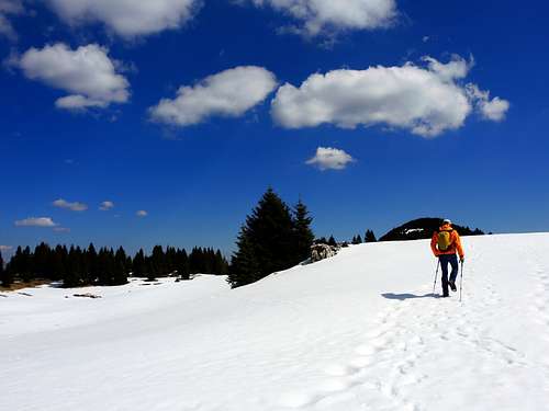
An easy but fine itinerary in a fantastic environment practicable even during the winter with snowshoes and known also by mountain bikers.
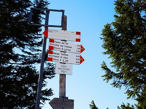
Near to the SAT signposts at the road bend on Passo Crocetta take a slightly uphill road in the forest (path n. 444), which at the beginning is an asphalt road, located on the right (on the left if coming from the Refuge Garda). The road enters a thick fir forest and soon reaches two buildings located on either side. It becomes a gravel track, crossing a large grassy area with a wooden observation tower just before the Passo del Dil. The route continues reaching the broad saddle of Passo del Dil 1724 m, where it is located the region border, passing from Trentino to Lombardy. From the little marked pass the former military road rises with moderate gradient below the summit ridge, dominating deep valleys on the left and cutting on the right the Southern slopes of Monte Lavino, a long crest covered with dwarf pines located between Passo del Dil and Passo del Cap. In front of us, it appears the view of the beautiful pair formed by Monte Caplone and Cima Tombea, the highest peaks within the Parco dell'Alto Garda Bresciano. The itinerary proceeds cutting the slope where it is possible to observe some artificial caves dating back to the period of the WWI.

|
")
|

|

|
After skirting Monte Lavino, continue along the gravel road reaching the Passo di Cap 1800 m, a broad grassy shelf between Monte Lavino and Cima Avez. In the vicinity of Passo del Cap the route changes direction and before starting to go down the gravel road reaches a fork. Here the main trail starts to descend to the Malga Pra di Lavino. Ignore it and turn to the right to walk up the moderate slope of the eastern side of Cima Avez, covered by a sparse coniferous forest. There are no signposts at this fork, anyhow there is no possibility of error. Infact the military gravel road is easily identifiable and starts to rise up with some hairpin bends. About halfway along the route, on the left are some magnificent limestone outcrops, deeply engraved by the erosive action of water.
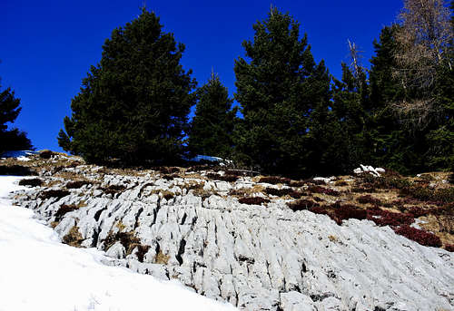
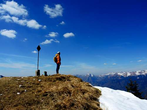
This is the karst phenomenon of the so-called "Campi solcati", a form of superficial karst. Arriving near the summit the wide mule track suddenly ends and on a small path we reach the summit ridge and the summit signal on a broad plateau in a few tens of meters to observe the breathtaking panorama, surprising above all on the glaciers of the Adamello and Presanella groups towards the West.
Descent: reversing the same itinerary
Italian version
Cima Avez dal Passo Tremalzo
Quota vetta: 1897 m
Difficoltà: E
Dislivello: 250 m dal rifugio
Un itinerario facile e interessante in un ambiente fantastico, praticabile anche d'inverno con le ciaspole e noto anche dagli appassionati di mountain bike.
In prossimità della segnaletica SAT, al tornante del Passo Crocetta, si imbocca una strada forestale in leggera salita (sentiero n. 444), che all'inizio è asfaltata, situata sulla destra (a sinistra se si proviene dal Rifugio Garda ). La strada si addentra in un fitto bosco di abeti e in breve raggiunge due edifici posti ai lati. Diventa poi una pista sterrata e attraversa un'ampia zona erbosa con una torretta di osservazione in legno poco prima del Passo del Dil. Il percorso prosegue raggiungendo l'ampia sella del Passo del Dil 1724 m, dove si trova il confine regionale, passando dal Trentino alla Lombardia. Dal valico, in realtà poco marcato, l'ex strada militare sale con moderata pendenza sotto la cresta sommitale, dominando a sinistra profondi valloni e tagliando a destra le pendici meridionali del Monte Lavino, una lunga cresta ricoperta di pini mughi situata tra il Passo del Dil e il Passo del Cap. Davanti a noi si apre il panorama sulla bellissima coppia di montagne formata dal Monte Caplone e dalla Cima Tombea, le vette più alte all'interno del Parco dell'Alto Garda Bresciano. L'itinerario procede tagliando il pendio, dove è possibile osservare alcune grotte artificiali risalenti al periodo della Prima Guerra Mondiale. Dopo aver costeggiato Monte Lavino si prosegue lungo la strada sterrata raggiungendo il Passo di Cap 1800 m, un ampio ripiano erboso tra Monte Lavino e Cima Avez. In prossimità del Passo del Cap il percorso cambia direzione e prima di iniziare a scendere la strada sterrata raggiunge un bivio. Qui il sentiero principale inizia a scendere fino alla Malga Pra di Lavino. Si svolta invece a destra per risalire con moderata pendenza il versante orientale della Cima Avez, ricoperto da un rado bosco di conifere. A questo bivio non ci sono indicazioni, comunque non c'è possibilità di errore. Infatti la strada sterrata militare è facilmente individuabile e inizia a salire con alcuni tornanti. A circa metà del percorso, sulla sinistra, si trovano alcuni magnifici affioramenti calcarei, profondamente incisi dall'azione erosiva dell'acqua. Si tratta del fenomeno carsico dei cosiddetti “Campi solcati”, una forma di carsismo superficiale. Giunti in prossimità della vetta l'ampia mulattiera termina improvvisamente. Su traccia raggiungiamo in poche decine di metri la cresta sommitale e il segnale di vetta su un ampio pianoro. Osserviamo il panorama mozzafiato, sorprendente soprattutto sui ghiacciai dell'Adamello e della Presanella verso Ovest.
Discesa: per lo stesso itinerario
Red Tape
No fees no permits required.
Hiking and scrambling grades of difficulty
T - Turistico (Tourist): Itineraries on wide, clear and well worn paths, sometimes on mule tracks or gravel roads. The routes are never exposed, don't give any orientation problems and don't exceed 2500 meters of altitude. Suitable also for children.
E - Escursionisti (Hikers): Itineraries on marked trails, even narrow and with possible steep and impervious sections. They are never exposed and don't give any orientation problems. They can tread different kinds of ground, such as forests, gravel, meadows, pastures, easy rocks, etc.). They form the majority of the trails that wind up in the mountains and require a certain habit to walk; you need equipment suitable for the altitude and resistant footwear with soles suitable for rough terrain.
EE - Escursionisti Esperti (Experienced Hikers): Itineraries for hikers with experience and good knowledge of the mountain. Some of these paths may have exposed sections, however brief, which require firm foot and no dizziness. They require the ability to adapt to particular terrain, such as steep grassy slopes or stretches of rocks with difficulties that can reach the 1st degree of the UIAA scale. They can also reach high altitudes (3000 m or more). Sometimes they may include unmarked sections, requiring a good sense of orientation. Snow slopes are possible, however which can be overcome without specific mountaineering gear (rope, harness, crampons, ice-axe).
EEA - Escursionisti Esperti con Attrezzatura (Experienced Hikers with equipment - The same as EE, in addition these routes require the use of via ferrata equipment (lanyards, harness, carabiners, heat sink, helmet). This kind of itineraries range from the trails with short easy and not much exposed sections, previously equipped with fixed ropes and iron pegs, to the true and more difficult Via Ferratas climbing on rocky walls or on aerial ridges and ledges, previously equipped with long stretches of iron ropes, iron steps, ladders without which proceeding would constitute a real climbing. It is necessary to know how to use the technical equipment and have a certain habit of exposure and mountaineering terrains.
Nature
Cima Avez is included inside the Parco Alto Garda Bresciano. From the botanical point of view the area of Tremalzo is famous for being a place of biodiversity, due to the presence of numerous endemisms, plants that are found only here and nowhere else. An example is the "Silene elisabethae", an endemic plant that grows between the limestone and dolomitic rocks of Tremalzo: the best period to observe this flower is between August and September.
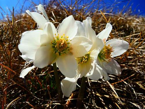
The slopes in the vicinity of Cima Avez are very rich in a very widespread and easily observable flower, the "Christmas Rose" or "Helleborus Niger", a species very present in the Tremalzo area and in all the Prealpi Bresciane e Gardesane. This flower has the particularity of blooming in winter, in December, hence the name "Christmas Rose". The beautiful blooming with large white flowers, sometimes with intense pink shades, lasts until the beginning of Spring.
Cima Avez è compresa all'interno del Parco Alto Garda Bresciano. Dal punto di vista botanico la zona di Tremalzo è famosa per essere luogo di biodiversità, per la presenza di numerosi endemismi, piante che si trovano solo qui e in nessun altro luogo. Un esempio è la "Silene elisabethae", una pianta endemica che cresce tra le rocce calcaree e dolomitiche di Tremalzo: il periodo migliore per osservare questo fiore è tra agosto e settembre.
I pendii nei pressi di Cima Avez sono ricchissimi di un fiore molto diffuso e facilmente osservabile, la "Rosa di Natale" o "Helleborus Niger", specie molto presente nella zona di Tremalzo e in tutte le Prealpi Bresciane e Gardesane. Questo fiore ha la particolarità di sbocciare in inverno, nel mese di dicembre, da qui il nome “Rosa di Natale”. La bella fioritura con grandi fiori bianchi, talvolta con sfumature rosa intense, dura fino all'inizio della primavera.
When to Climb
All year round.
Accomodation
This area is a primary touristic destination, offering several hotels, agriturismo, bed and breakfast, renting rooms and apartments. In the vicinity of Passo Tremalzo there are two shelters:
the Rifugio Garda and the Rifugio Garibaldi.
Bibliography
"Prealpi Bresciane" - Fausto Camerini - Collana Guide dei Monti d'Italia CAI - TCI
Meteo Forecast
Meteo Trentino
Meteo arpalombardia