
-
 25246 Hits
-
 83.1% Score
-
 16 Votes
|
|
Mountain/Rock |
|---|---|
|
|
46.97096°N / 11.18876°E |
|
|
Bolzano Alto-Adige |
|
|
Mountaineering |
|
|
Summer |
|
|
11213 ft / 3418 m |
|
|
Overview
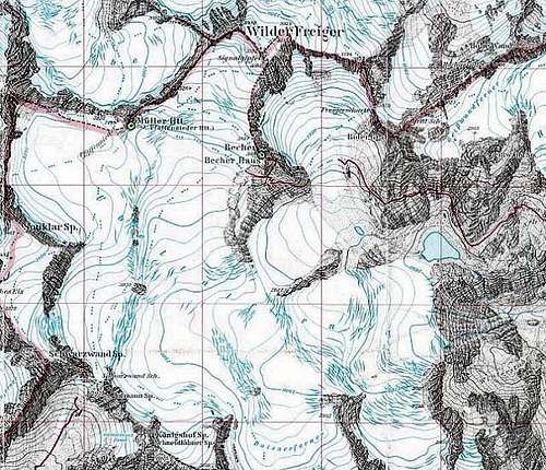
Wilder Freiger - Cima Libera 3418 m
As all the mountains belonging to the regions located near the boundaries between Italy and Austria, this peak has two names: Cima Libera, the italian name, and Wilder Freiger, the original tyrolese place-name. Wilder Freiger is a mountain in the Breonie Alps (Stubai Alps) in the Eastern Rhaetian Alps. It lies along the border between Italy and Austria in the "Middle Hauptkamm" between Pfaffennieder and Freigerscharte. It's the seventh highest summit of the Stubai Alps after Pan di Zucchero-Zuckerhütl 3507 m, Pfaffenschneid, Schrankogel 3497 m, Ruderhofspitze 3474 m, Sonklarspitze 3467 m, and Cima del Prete-Wilder Pfaff 3456 m.


This ice-covered mountain is one of the most visited summits in the region: from all the sides, the main routes are glacier-walks and many huts make the approach easy. The Wilder Freiger has a rather round shape. Sulzenauferner and Freigerferner cover the North face. To the South, on italian side, the Übertalferner is the biggest glacier of the Stubai Alps. Secondary summits : - Becher (Bicchiere) on the S ridge (with the Becher Hut, Rif Gino Biasi al Bicchiere) - Signal summit (3392 m) on the SE.
First ascent: 1865 by Leis.
Getting There
Approach to Cima Libera is possible :
- from Italy via Bolzano. Nearest airports are Milano and Verona. From here two possibilities :
a) over Vipiteno (Sterzing) and Val Ridanna (Ridnaun Tal). To Vipiteno with the train (station on the line Innsbruck - Bolzano) or with the Brenner highway (15 km before the pass on the italian side). To Val Ridanna over Stanghe. The endpoint of the road in Masseria (Maiern) can be reached by car or by bus.
...")

b) over Val Passiria (Passeier Tal) via Merano (Meran). From Merano, follow the Val Passiria to San Leonardo and then the road to Passo del Rombo (Timmelsjoch, Austrian border). The starting point is Belprato, 10 km before the pass.
- from Austria via Innsbruck, Stubaital and Sulzenau Hut, Nürnberger Hut or Stubaier Gletscherbahn Middlestation.
Nearest airport and station: Innsbruck
Routes Overview
Normal Route from Rif. Biasi al Bicchiere (Becher Hut)
From Vipiteno-Sterzing the route goes along the whole Val Ridanna - Ridnaun, to the last parking lot (1417 m, Museum of Mining). Take the path n. 9 getting Aglsboden alm 1717, Rifugio Vedretta Piana - Grohmannhütte 2254 m (10 places overnight; 2.30 hours from the parking lot) and to Rifugio Vedretta Pendente - Teplitzer Hut 2586 m (50 places overnight, 1 hour more). Always follow path n. 9 (with fixed ropes), pass the moraine and briefly cross the glacier; follow the path climbing with several hairpins (some steps with fixed ropes) the rock on which it's located the refuge Biasi al Bicchiere 3195 m, 100 people overnight; 2.30 from Rif. Vedretta Pendente). From the hut go down towards North to a fork at 3156 m, then to the glacier. Heading always to the North the route keeps the glacier's edge or alternatively the rugged and steep ridge with trail (gory passages with fixed ropes), finally getting the point with the "signal" at 3393 m, from which the summit cross 3418 m is gained briefly and without no more difficulties (1 hour from the hut).
Descent: reversing the route

Normal Route from Rif. Cima Libera
From Belprato/Schönau 1794 m - along the road towards Passo del Rombo/Timmelsjoch (parking lot before the bridge) - take the gravel road to Malga del Tumulo. From here follow the path getting the amazing Lago Nero del Tumulo/Grosser Schwarzsee 2508 m, skirt the lake and then follow the well worn trail rising to the upper terrace, where there are other small lakes and the upper meandering stream. From the terrace climb up along the steep snowfields to the saddle named Forcella di Croda Nera/Schwarzwand Scharte 3062, where it appear a brethtaking view towards the glacier named Vedretta di Malavalle/Übeltalferner. Rope up and cross the glacier, getting Rifugio Cima Libera/Pfaffenniederhütte 3145 m

Other routes on the Austrian side:
1) From Sulzenau Hut, 1200 m height difference a) Seescharte - 4,5 hours : easiest route (blue marks) b) Lübeckerweg - 4,5 hours c) Müllerhütte - 4,5 hours d) Leo`s Route - 4 hours Descent to the hut 3,5 hours
2) From Nürnberger Hut over Seescharte

Red Tape
No permits, no fees required.
- Highway tax in Autria (vignette) - Highway toll in Italy
Huts

Rifugio Biasi al Bicchiere/Becherhaus 3195 m
The highest hut in the Stubai Alps. Open from begin july to end september 40 beds 65 lager Adress : Erich Pichler Schmiedgasse 1 I-39010 St.Martin i.P. Südtirol Tel. 0039-0472-656377 (Hut) Tel. 0039-0473-641490 (Valley) Fax 0039-0473-641197 CAI Verona via S. Toscana 11, I-37126 Verona
To get there : - Ascent 8 hours from Ridanna (Ridnaun). From the end of the road of val Ridanna (Ridauntal), take the path n° 9 to the huts Vedretta Piana (Grohmann Hut) and Vedretta Pendente (Teplitzer Hut). Always over path n° 9, walk along the lake Vedretta di Malavalle, to the tong of the glacier Übeltalferner. The rocky ridge of Bicchiere is fitted with fixed ropes and leads to the hut
- from Timmelsjochroad 7 hours. At Gasthof Hochfirst (Timmelsbrücke) over Belprato (Schönau) follow path Nr. 30 to Timmels Alm/Großer Schwarzsee, and to Schwarzwandscharte (3.059m), over the Übeltalferner to Becherhaus (3.195m).
- From Rifugio Cima Libera/Müller Hut 1 hour
Rifugio Cima Libera/Muellerhuette 3148 m
20 beds 70 lager
To get there : - from Stubaital with using the Gletscherbahn to Middlestation/Dresdner Hütte (2.300m) 4,5 hours Over Peiljoch (2.676m) and glacier Fernerstube to Pfaffennieder (climbing path) to Müllerhütte (3.143m), and over Übeltalferner to Becherhaus (3.195m).
- from Ridanna (Ridnaun), 8 - 9 hours. From the end of the road of val Ridanna (Ridauntal), take the path n° 9 to the huts Vedretta Piana and Vedretta Pendente (Teplitzer Hut). Always over path n° 9, walk along the lake Vedretta di Malavalle, to the tong of the glacier Übeltalferner. Before reaching the Becher Hut, after the Becher Rock (fixed ropes) turn to the left over permanent snow in approx. 3000 m height and cross the Übeltalferner in W direction (crevasses) to the hut.
- from Timmelsjochroad 7 hours. At Gasthof Hochfirst (Timmelsbrücke) over Belprato (Schönau) follow path Nr. 30 to Timmels Alm/Großer Schwarzsee, and to Schwarzwandscharte (3.059m), over the Übeltalferner to Müller Hut.
Open from begin june to begin october 48 beds 82 lager Adress : Fam. Siller Martina and Leonhard Schulweg 28 A - 6167 Neustift im Stubaital / Tirol Privat Tel. & Fax 05226 / 30496 Hut Tel. & Fax 05226 / 2492 e-mail: nuernbergerhuette@aon.at
To get there : Park at Ranalt . Over Bsuchalm the hut can be reached in 2,5 hours. Take the forest path to Bsuchalm; the beautiful section over the forest leads easy to the hut.

- SULZENAU HUT 2196 m Home page Open from begin june to begin october 40 beds 100 lager Adress : Norbert Schöpf 6167 Neustift im Stubaital Tel/Fax Hütte ++43 5226 24 32 Tel. Tal ++43 5226 24 55 Fax DW 3 info@sulzenau.com
To get there : Parking at the beginning of way approx. 200 m after the Grawaalm at the Stubaier glacier route in Neustift/Ranalt. 600 height difference , 2 hours going. Cross the mountain stream and climb in turns to the forest border to the Sulzegg. There the path leads into the back of the valley of the Sulzenau. Pass the nearly even valley soil to the Sulzenaualm. After the Alm the slopes traverse on the right side in turns up to the hut.
When To Climb
The mountain is usually climbed between June to September or with skis.
Other Targets near the Wilder Freiger
1) Hikes : - Niederl (2.627m) - Peiljoch (2.676m) - Mairspitze (2.781m) - Old Wegmacherhut Hundsheim (2.850m) - Great Trögler (2.902m) - Feuersteine E summit 3.267 m W summit 3.246 m - Aperer Feuerstein 2.968 m - Maierspitze 2.775 m - Rotgratspitz 3.099 m 2) Ice tours - Gamsspitzl (3.050m) : easy, for beginners - Sonklarspitze (3.467 m) - Botzer (3.250 m) - Wilder Pfaff (3.458 m) - Zuckerhütl (3.507 m)
Meteo
Guidebooks and Maps
"Stubaier Alpen" by Dieter Seibert Ed Rosenheimer, 1994
The recommended guide is the "Alpenvereinsführer" "Stubaier Alpen - alpin" by Walter Klier (Bergverlag Rother) A detailed map is available from the Alpenverein (Hochstubai - 31/1 1: 25000) A good map showing the Stubai Alps in complete as well as parts of the Zillertaler alps is sold by freytag & berndt (Innsbruck Stubai - Sellrain Brenner 1:50000, WK241).
External Links
- Zuckerhütl SummitPost page of Zuckerhütl
- Ruderhofspitze SummitPost page of Ruderhofspitze
- Sonklarspitze SummitPost page of Sonklarspitze
- Wilder Pfaff SummitPost page of Wilder Pfaff
- Home page Home page of Sulzenau Hut
- Home page Home page of Nürnberger Hut
- Austrian Map online Online digital maps of Austria (OEK 50, OEK 200 and OEK 500) by the BEV (Bundesamt für Eich- und Vermessungswesen) - in German