La montagna chiama i suoi figli, ed essi rispondono fedelmente al suo appello…
Osvaldo Cardellina, Diario alpinistico, 1964-65
Page texts: @ OsvaldoCardellina"Osva", passed away on May 2, 2022. Page owners: Christian Cardellina e Osvaldo Cardellina. Any updates from September 12, 2022: Antonio Giani, page administrator, friend and climbing companion.
Testi della pagina: @ OsvaldoCardellina "Osva", scomparso il 2 maggio 2022. Proprietari pagina:Christian Cardellina e Osvaldo Cardellina. Eventuali aggiornamenti dal 12 settembre 2022: Antonio Giani, amministratore della pagina, amico e compagno di salite.
Overview
How many ways are there to go from the wide Pila Basin to Cogne Resort and vice versa? Seven. These are the routes that connect these two places through the Valley of Dora Baltea with that of Torrent Grand'Eyvia and then to that of "tying" the City of Aosta with Cogne Commune. A journey that is lost in the mists of time and made by various procedures and steps quite diversified, especially given the point of departure or the arrival date. There at that place, over the long ridge from Punta de la Pierre, known by all as "La Pera" (2.653m), at the West and above Ozein of Aymavilles reachs Col Tsa Setze or Chaz Sèche (2.815m), there is the Valley Cogne and the Gran Paradiso. In ancient times it was the "Iseran", namely the large area of mountains that were heading for the valleys of Orco and Isère. Then the watershed gets up to one "Spallone" (Great Shoulder) reaching the Tip of Valletta (3.007m, 3.090m), the culmination of this tiny subgroup that ends at Colle Garin, once called "Bassa di Garin" (Low Garin, always 2.815m) before heading to the Group of Mount Emilius. I never knew, despite the researchs done, nothing more than about the name Garin, while Tsa Setze means alp very high, perhaps the last and certainly lack of waters, ie dry. Most likely in the old days, when it was also exploited the last blade of grass, there had to be on the Northern Slope over the Plan de l'Eyve or Eyvie (more water into the tableland) or on the Southern or Arpisson the last pastures, real outposts before reaching the Col Tsa Sétze. In fact, while on the side of Pila Basin are still a trace of the rushing water from under the hill that joins the tiny emissary from a pond (2.525m) at the Western foot of Mont Belleface Punta Valletta (2.970m, 3.090m) forming the Torrent de Plan de l'Eyvie, on the opposite side of Cogne we find nothing. Only two gutters or Torrent de Chasèche and parallel Torrent de Piscicail run through, but from under the Tip Tsavanis and above Epinel, this South side; then to track the water must go down in the center of the more large Vallon of Arpisson, where, at the Plan Bessey, the junction 2.525 meters for Col Garin find a spring gushing from a rock. Or down at the Torrent Arpisson nearby homonymous pasture. Here reappears the name Tsa Sètze becoming Chasèche, which then determines that of the hill above the apex of this small and desolate valley.
Quanti modi ci sono per andare da Pila a Cogne e viceversa? Sono sette. Questi sono gli itinerari che collegano queste due località passando dalla Valle della Dora Baltea a quella della Grand'Eyvia e quindi "legando" la Città di Aosta al Comprensorio di Cogne. Un viaggio che si perde nella notte dei tempi e compiuto tramite diverse modalità e passaggi alquanto diversificati, soprattutto in considerazione del punto di partenza o di quello di arrivo. Là, oltre quella lunga cresta che dalla Punta de la Pierre, conosciuta da tutti come "La Pera" (2.653 m), all'estremità Occidentale e sopra il Villaggetto d'Ozein di Aymavilles raggiunge il Colle Tsa Sètze o Chaz Sèche (2.815 m), esistono la Valle di Cogne ed il Gran Paradiso. Nei tempi antichi miticamente era considerato il lontano "Iseran", ovvero quella grande area di montagne che declinavano verso le Valli dell'Orco e d'Isère in Francia. Poi lo spartiacque si rialza ad uno Spallone raggiungendo la Punta della Valletta (3.007 m, 3.090 m), il culmine di questo minuscolo sottogruppo che si conclude al Colle Garin, una volta chiamata "Bassa di Garin" (sempre 2.815 m) prima di dirigersi verso il Gruppo dell'Emilius. Non ho mai saputo, nonostante le ricerche effettuate, nulla di più del toponimo Garin, mentre Tsa Sètze stà a significare un'alpe molto alta e forse l'ultima e certamente scarsa e povera in acque, cioé piuttosto secca e forse pur arida. Molto probabilmente nei tempi andati, quando veniva sfruttato sin l'ultimo fil d'erba, dovevano esistere sia sul Versante Settentrionale sopra il Plan de l'Eyve od Eyvie (sempre dell'acqua) oppure sul Meridionale o d'Arpisson degli ultimi alpeggi, veri avamposti prima di raggiungere il Col Tsa Sètze. In effetti mentre sul lato Pila troviamo ancora una traccia dello scorrer dell'acque da sotto il colle che si unisce al minuscolo emissario proveniente da uno stagno (2.525 m) alle pendici Occidentali di Mont Bellefaçe e Punta Valletta(2.970 m, 3.090 m) formando il Torrent de Plan de l'Eyvie, su quello opposto o di Cogne non troviamo nulla. Solo due rigagnoli o Torrent de Chaseche e Torrent de Piscicail percorrono, ma da sotto la Punta Tsavanis e sopra Epinel, questo versante Meridionale; quindi per rintracciare l'acqua bisogna scendere nel centro del Vallone d'Arpisson, dove, presso il Plan Bessey, al bivio pel Col Garin ritroviamo una sorgente sgorgante da un masso (2.525 m). Oppure scendendo al Torrent di Arpisson nelle vicinanze dell'omonima alpe. E qui riappare il toponimo Tsa Sètze trasformato in Chaseche, che poi determina quello del soprastante colle all'apice di questo valloncello desolato.
And for the inhabitants of Cogne? Much the same thing. But that ridge forced their to a long tour Aymavilles to gain access to the Dora Valley and Augusta. Where he spent the ancient "Via delle Alpi" connecting Amsterdam to Venices and bypassing the Colli dell'Arietta, Scaletta (Small Ladder) and Acque Rosse with a large business that tied all of Europe down through the entire Valley of Cogne reaching Aymavilles and Villeneuve and then cross the Gran San Bernardo, after scoring four in the European Fairs in Thora or Thouraz, destroyed by a huge landslide at dawn on 6 July 1564. Moreover with half on "Salassian Route" towards Gignod and then with the Via Francigena passing through Gignod, Etroubles, St. Oyen and St. Rhémy always towards the Great in the directive that linked Canterbury to Rome. So the "Cogneins" were accustomed to these transits linking the ancient Conia also with transporting ore by the Romans to the Piedmont and the passage of all these "intruders" towards the Valley of the Dora Baltea. But when they decided to go to St. Marcel, Brissogne, Charvensod, Gressan and Jovençan the speech was different; preferred, the most experienced and knowledgeable of the area, climb the ridges passing in high hills. By that of St. Marcel in the East than the Drink to the West; so for the Pila Basin, which then existed only with ups and seeds isolated pastures. In fact we not find passing notes until 1870, when Monsieur P.-L. Guignard in "Echo des Alpes" in 1877 with the title "Corespondance", pages 71/2 said that to travel from Aosta to Cogne it is passed from a hill at the Tip of the Valletta (3.090m). A report so chaotic that demonstrates how confused, but did not find guides and information on the spot, as the route between the two major centers was not as widely known by everyone. The unusual move from Charvensod Hamlet towards Cogne Common was through "un col 9,000 pieds, dont je ne pus savoir le nom et gravis la cime la plus rapprochée qui, d'après le barométre accusait 9,900 p. environ ...". Surely the Hill of the Valletta (3.000 meters), with a choice of itinerary so reckless as tiring ignoring neighbors Hills "Bassa de Garin" Tsa Sètze (both 2.815m) but for him misleading, since the first addressed by Arbolle Eastward and according by Chamolé toward South-southwest. But the ideas were very clear to the villagers, who passed for the same always, also with the their cattle. A serie of transits usual to cross by one valley to another, moving the same or simply to get to a TSA or a hill to graze the herd.
E pegli abitanti di Cogne? Più o men lo stesso. Quella cresta costringeva ad un lungo giro fino ad Aymavilles per poter accedere alla Valle della Dora ed Augusta. Dove passava l'antica "Via delle Alpi" collegando Amsterdam alle Venezie e scavalcando i Colli dell'Arietta, Scaletta ed Acque Rosse con un grande commercio che legava tutta l'Europa scendendo l'intera Valle di Cogne sino ad Aymavilles e Villeneuve per poi attraversare il Gran San Bernardo, dopo aver realizzato quattro Fiere Europee a Thora o Thouraz, distrutta da enorme frana all'alba del 6 Luglio 1564. Oppure per metà sulla Via dei Salassi fino a Gignod e quindi con quella Francigena transitando per Gignod, Etroubles, St. Oyen e St. Rhémy in direzione sempre del Grande nella direttiva che univa Canterbury a Roma. Quindi i "Cogneins" erano abituati a questi transiti che collegavano anche Conia col trasporto del minerale da parte dei Romani verso il Piemonte ed al passaggio di tutti questi "intrusi" verso la Valle della Dora Baltea. Ma quando decidevano di andare a St. Marcel, Brissogne, Charvensod, Gressan e Jovençan il discorso era ben diverso; preferivano, valligiani i più esperti e conoscitori del territorio, scavalcare le creste passando in alto sui colli. Da quello di St. Marcel ad Oriente a quello del Drink a Ponente; così anche per Conca di Pila, che allora non esisteva se non con alti e semi isolati alpeggi. Infatti non troviamo note di passaggio fino al 1870, quando Monsieur P.-L. Guignard in "Echo des Alpes" 1877 col titolo "Corespondance", pagine 71/2 narra che per recarsi da Aosta a Cogne sia transitato da un colle presso la Punta della Valletta (3.090 m). Una relazione tanto caotica quanto confusa che dimostra, non avendo trovato guide ed informazioni in loco, come l'itinerario tra i due importanti centri non fosse così diffusamente da tutti conosciuto. L'inusuale passaggio da Charvensod a Cogne avveniva tramite: "un col 9,000 pieds, dont je ne pus savoir le nom et gravis la cime la plus rapprochée qui, d'après le barométre accusait 9,900 p. environ ...". Sicuramente il Colle della Valletta (3.000 metri circa), con scelta d'itinerario tanto scriteriata quanto faticosa ignorando i vicini Colli di Garin e di Tsa Sètze (entrambi 2.815 m) ma per lui ingannevoli, poiché il primo rivolto da Arbolle ad Est ed il secondo da Chamolé a Sud-sudovest. Ma le idee erano ben chiare ai valligiani, che passavano per i medesimi da sempre, anche col loro bestiame. Transito usuale per traversare da una valle all'altra spostando il medesimo o più semplicemente per arrivare ad una TSA od a un colle per pascolarne la mandria.
Getting There
BY CAR:
From TORINO, MILANO, etc: Motorway A5. Exit at IVREA or Quincinetto (PIEDMONT).
From IVREA Town: Charvensod, Gressan, Jovençan, Aymavilles Municipalities.
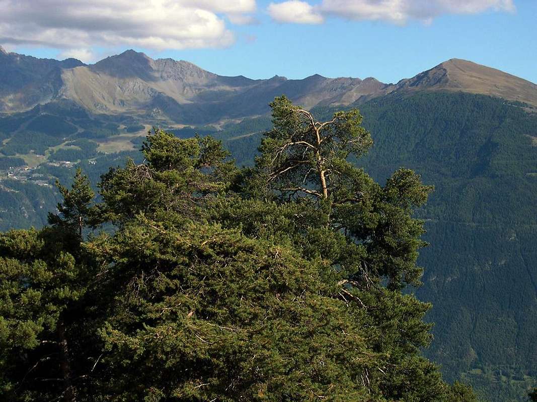
Northern Roads from Dora Baltea Central Valley From Charvensod (main road from Pont Suaz Fraction 567m) with Regional Road towards Reverier Dessus, Péroulaz, Les Fleurs, Petite and Grande Cerise, Eaux Froides, Charémoz, Rosselin Hamlets up to the Pila-Resort. From Gressan (603m; alternative road) towards Leysettaz, Tivet, Les Fleurs Hamlets (1.292m, 1.414m) Pila Basin and Resort (low parking nearby Cableway 1.800m; upper parking 1.850m). From Jovençan(631m) to Western Pila Conca, exclusively through path-muletrack to Tourlin Dessous(1.466m) and by dirt road to Pila-Posse Tennis (1.776m). From Aymavilles(646m) to Western Pila Conca, through Main Road to Cogne Valley, alternative road to Ozein/Turlin di Milieu and Dessus Hamlets and dirt road towards Bren Alp and Pila-Posse.
Southern Roads from Cogne-Resort and Grand'Eyvia Valley From Aymavilles(646m) towards Cogne Valley: reacging Vieyes (1.132m), Epinel, Crétaz Hamlets to Cogne(1.534m); through Main Road. From this by Regional Road towards Montroz and Gimillan(1.785m) Villages; from the last towards the above Arpisson/Tsa Sètze Southern Vallons.
From FRANCE: through the Mont Blanc Tunnel to Entrèves-crossroads to Vény/Ferret Valleys - Mountain Guides of Courmayeur - La Saxe Rock Gym - Courmayeur. By Little Saint Bernard Pass, closed since November until half May to La Thuile Valley - Pré Saint Didier - Courmayeur. It is not necessary to take Motorway A5: you can drive on SS.26, in the direction of AOSTA - IVREA - TURIN.
BY PLANE:
Aeroporto "Corrado Gex" Saint Christophe (Aosta).
Routes Description
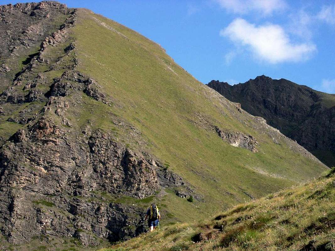
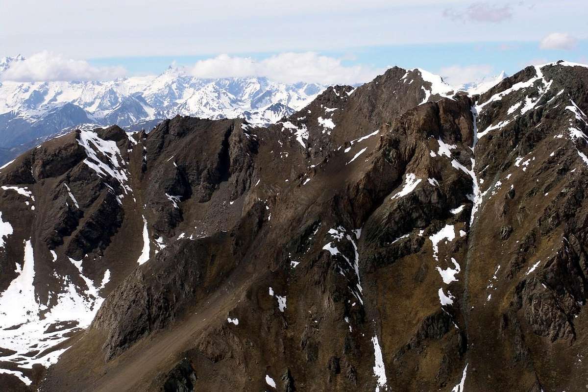
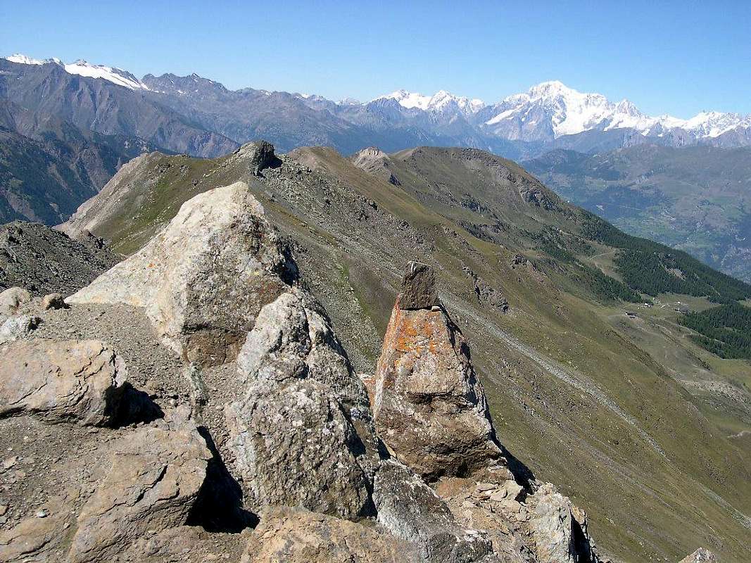
There are seven hills to transit from Cogne Pila and vice versa. Analyze them quickly and then conclude with the classic route suggested by us for a nice Hike. 1) - From Col Arbolle (3.154m) through to that des Laures (3.035m) and descent to the four Lakes Lussert, Grauson Valley, Gimillan, Montroz Villages and Cogne Municipality. It is a route for Experienced Hikers or Mountaineers who want to connect four vallons: Chamolé, Arbolle, Laures and Lussert-Grauson. It is rarely performed and is quite long and strenuous. You can shorten rising to Chamolé Upper Station by chairlift or in Gimillan driving in asphalt road; also it can be divided into two parts when using the Refuge Arbolle. 2) - Via the Pas du Valaisan (3.210m) coming from Pila Resort and through the Chamolé Pass (2.641m) to the Refuge Arbolle (2.516m), route of about half of the namesake valley and slopes of the Western Slope of the Pass and finally down as in the previous route. Via a purely Mountaineering Route and exposed to the falling stones with a route nowadays almost completely abandoned, partly because of changed conditions rather than at the end of the '800 as in "Guide Western Alps" in 1896 by Bobba & Vaccarone. 3) - Always proceeding with semicircular description from Northeast to the Southwest, through the Col or "Bassa de Garin" (Low) with a route frequented by long time and then fell somewhat into disuse. The construction of the new Shelter Arbolle in 1998 and the installation of Bivouac Franco Nebbia (2.741m) in the adjacent Arpisson Vallon in Cogne Valley in 2004 have again revived and today is frequently and rightly popular with beautiful crossing. It looks like a path easy, safe and well served by footpaths on both sides. 4) - We've talked about this in Overview, where the story done well we understand the futility of this pass that requires a drop of 200 meters longer than the nearby Garin Tsa Setze Hills. In addition, the course is boring with steep rocks and residual snowfields on the Northern Slope above Lake Arbolle (2.496m) and Refuge, while in the South it becomes treacherous for the presence of a rocky band rather steep, rotten and with dangerous debris and grassy slopes. Definitely not recommended and should be avoided. 5) -Towards the Basin Plan de l'Eyve to the overhanging mall Vallon Tsa Setze under the North Slope of Punta Valletta (3.090m) with descent to the Arpisson Vallon above theValley of Cogne through the Saddle 2.587 meters at the Tip Tsavanis (2.816m). An itinerary "classic" that from Pila leads to Epinel or Gimillan passing on the Arpisson Pasture (2.328m), served by good footpaths on both sides. Fell into gradual abandonment after the construction of the Shelter Arbolle, he has taken to be well attended after the installation of the Way Overview from Punta de la Pierre in crossing to the same and after the equipment of the Via Ferrata on the West-southwest Ridge of Valletta. It also allows you to combine with the ascension of the homonymous and nearby Punta (2.824 m) or just more to the Southeast with that of Tsavanis. Great views in foreground of the nearby Grivola (3.969m) and over the entire Chain of the Gran Paradiso up to the Tower of Lavina (3.308m), towards the end of Eastern Graian on the border with Piedmont. 6) - Expanding the tour to the Southwest from Pila-Gorraz (1.850m) at the Grand Grimod Dessus (2.232m) and from there to Colle del Drinc (2.579m) both to close the Couìss (2.637m), both at the turn of Bivouac Simone Faccarello "Arno" (2.660m), with a long descent diagonally below the watershed between the Basin of Pila and Cogne Valley in the middle course of Grand'Eyvia up to go down to the Hamlet of Epinel (1.433/52m). Is a Hike very long and pretty tired that has generally the same as half the camp, especially from the Northern side of Pila where is seconded from the ski lifts for skiing, but is very rarely traveled into Cogne, where looks really as primordial and more than wild. 7) - Crossing that connects the Eastern sector of the Basin Pila to the Village of Ozein-Chantel (1.359m), above the Aymavilles Common, now the entrance of the lower Cogne Valley. always from Pila-Gorraz (1.850m) towards the Grimondet Pasture (2.105m) below the Grand Grimod and Punta de la Pierre and through the hill of the latter (2.653m, 2.584m). A "local" traverse popular in the past but recently almost completely fallen into disuse and frequented almost exclusively as a destination for Ski-Mountaineering.
Sette i colli per transitar da Cogne a Pila e viceversa. Analizziamoli rapidamente concludendo con l'itinerario classico da noi suggerito per una bella Escursione. 1) - Tramite il Col di Arbolle (3.154 m) attraversando a quello des Laures (3.035 m) e discesa verso i Laghi di Lussert, Vallone del Grauson, Gimillan, Montroz e Cogne. Si tratta di un itinerario per escursionisti esperti oppure Alpinisti che vogliono collegare quattro valloni: Chamolé, Arbolle, Laures e Lussert-Grauson. Viene assai raramente effettuato e risulta alquanto lungo e faticoso. Si può abbreviare salendo a Chamolé in seggiovia od a Gimillan in auto; inoltre può essere diviso in due parti pernottando al Rifugio di Arbolle. 2) - Con il Pas du Valaisan (3.210 m) arrivando da Pila e pel Col di Chamolé (2.641 m) fino al Rifugio d'Arbolle (2.516 m), percorso di circa la metà dell'omonimo vallone e risalita del Versante Occidentale del Passo ed infine discesa come nel precedente itinerario. Una via prettamente Alpinistica ed esposta alle cadute di pietre con un itinerario oggigiorno praticamente del tutto abbandonato anche a causa delle condizioni alquanto cambiate rispetto alla fine dello '800 come in "Guida Alpi Occidentali" 1896 di Bobba & Vaccarone. 3) - Sempre procedendo da Nordest verso Sudovest, per mezzo del Col o "Bassa di Garin" con un itinerario frequentato da molto tempo e poi caduto un pò in disuso. La costruzione del Rifugio di Arbolle nel 1998 e la posa del Bivacco Franco Nebbia (2.741 m) nello attiguo Vallone di Arpisson in Valle di Cogne nel 2004 lo hanno nuovamente rilanciato ed oggi viene frequentemente e giustamente frequentato con bella traversata. Si presenta come un percorso facile, sicuro e ben servito da sentieri su entrambi i lati. 4) - Già detto di questo colle in Oveview, ove dal racconto effettuato ben si comprende l'inutilità dello stesso richiedente un dislivello di circa 200 metri in più rispetto ai vicini Garin e Tsa Sètze. Inoltre il percorso é noioso con ripide pietraie o residui di duri nevati sul Versante Settentrionale sopra il Lago d'Arbolle (2.496 m) e soprastante Rifugio, mentre a Meridione diventa insidioso per la presenza d'una fascia piuttosto ripida di rocce marce e pericolosi pendii detritico-erbosi. Decisamente sconsigliabile e da evitarsi.
5) - Dalla Conca di Plan de l'Eyvie al soprastante Valloncello di Tsa Sètze sotto il Versante Settentrionale della Punta della Valletta (3.090 m) con discesa verso il Vallone di Arpisson a Cogne tramite la Sella 2.587 metri presso la Punta di Tsavanis (2.816 m). Un itinerario "classico" che da Pila porta ad Epinel o Gimillan passando per l'Alpe di Arpisson (2.328 m), servito da buoni sentieri su entrambi i versanti. Caduto in progressivo abbandono dopo la costruzione del Rifugio di Arbolle, ha ripreso ad essere ben frequentato dopo la installazione della Via Panoramica dalla Punta de la Pierre in traversata verso lo stesso e dopo l'attrezzatura della Via Ferrata sulla Cresta Ovest-sudovest della Valletta. Consente inoltre di combinare con l'ascensione dell'omonima e vicina Punta (2.824 m) oppure, appena più verso Sudest con quella del Tsavanis. grandiose vedute affronte sulla vicina Grivola (3.969 m) e su tutta la Catena del Gran Paradiso fino alla Torre di Lavina (3.308 m), verso l'estremità delle Alpi Graie Orientali ai confini con il Piemonte. 6) - Allargando il giro verso Sudovest da Pila-Gorraz (1.850 m) al Grand Grimod Dessus (2.232 m) e da questo al Colle del Drinc (2.579 m) oppure al vicino del Couìss (2.637 m), entrambi a cavallo del Bivacco Simone Faccarello "Arno" (2.660 m), con lunga discesa in diagonale al di sotto dello spartiacque tra il Bacino di Pila e la Valle di Cogne nel corso medio della Grand'Eyvia fino a scendere alla Frazione di Epinel (1.433/52 m). Escursione lunga ed abbastanza faticosa che ha in genere come metà il bivacco stesso, soprattutto dal lato di Pila dove é assecondata dagli impianti di risalita per lo sci, mentre viene assai raramente percorsa su quello di Cogne, dove si presenta veramente più che selvaggia. 7) - Traversata collegante il settore Orientale della Conca di Pila con il Villaggio di Ozein-Chantel (1.359 m), sopra il Comune di Aymavilles ed ormai all'ingresso della parte inferiore della Val di Cogne. Sempre da Pila-Gorraz (1.850 m) all'Alpeggio del Grimondet (2.105 m) sottostante al Grand Grimod ed alla Punta de la Pierre e tramite il colle di quest'ultima (2.653 m, 2.584). Una traversata locale" frequentata nel passato ma recentemente quasi completamente caduta in disuso e frequentata quasi esclusivamente in Sci-Alpinismo.
More specifically the "our" traverse
Let us analyze in more detail the "our" crossing from North to South, or from the Basin Pila to Col Tsa Setze and down into the Arpisson Vallon in Cogne Valley.
First part: various possibilities to reach Lake Chamolé and then the Plan de l'Eyvie en route to the Col Tsa Setze
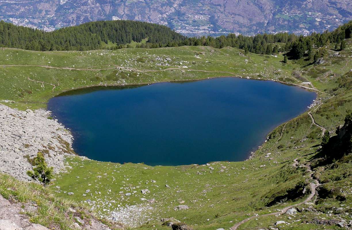
You can reach the Chamolé Lake (2.325m), under the Testa Nera (Black Head; 2.820m) and just to the East of the arrival Stationl of the Chair lift with the same name (2.311m). The use of this and its crossing to the East via easy trail- muletrack is a popular revolt to the mass, whereas on the deep small vallon above the Alpe di Chamolé you make a beautiful Walk-Hike. There are three possibilities:
1) - reached the ruins of Alp Chanté, instead of reaching that of Chamolé, continue straight to South by means of a clear path not numbered, in the middle of the Bois du Jardin Public and between wide expanses of violets, the trail reaches above a little further away from the lake.
2) - reached the Chamolé Pasture climb above the water intake, directly behind the fountain, and the route n° 4/19A/102 and path almost parallel to the previous one reaches the same.
3) - Or, and even more to the East through the trail n° 19 that passes beneath the watershed with Comboé, reaches the emissary of the same, just at the point where the branches start to the Chamolé Pass South (2.641m; to the Refuge Arbolle 2.516m) and the two Hills South and North of Replan. Other options to reach the lake are represented by the trail n° 19B, that from Pila-Gorraz Dèsott (1.930m), after a voyage to the East, the interior rooms of the Bois de Chanté passing below the Chairlift; or more to the West, but by far the most laps with wide paths 19C/22 typically concurrent or near the ski slopes "of the Wood or Renato Rosa, of Fagiani or Nouva". The same do not recommend it either too steep or definitely "dispersive" forcing strenuous climbs or too out of the ideal line of ascent, although you can get more of the same experiences to learn more about the entire Area of Pila in its upper-middle part and to the base of its mountains. This applies to the industry's most Eastern and Central part that concerns the most vital part of the Resort, that from the watershed with the Vallon of Comboé, in the Common of Charvensod, reaches the opposite over the Municipality of Aymavilles at the border with Cogne Valley. From the industry's most popular tourist fact "open" Westward great forests, unfortunately crossed by too many ski lifts for Skiing and traversed by a disproportionate number of farm roads that respectively reach Punta del Couiss (2.611m) and the average altitude of the mountain pastures in 2.200/300 meters around. A trip "classic" and quite popular is the one that, by starting from the Upper Station of the Cable Car Chamolé diagonally in the Southwest through the farm dirt road concomitant with the trail 19C/TVC, reaches slightly downhill the turnoff 2.231 meters, where they arrive also the private dirt roads coming from the runs Skiing of the "Nouva and Leissé". From this, turning to the South with the trail 22/TVC, you reach the renovated Pasture of Plan de l'Eyvie or Eyve (2.253m; Ground Water), located at the foot of the West Ridge of Mont Bellefaçe, as well as at the beginning of the path that leads to the Tsa Sètze Hill (2.815m), between Pila and Cogne Valley.
Second part: from Chamolé Loch or more directly towards the Plan de l'Eyvie and Tsa Sètze Hill
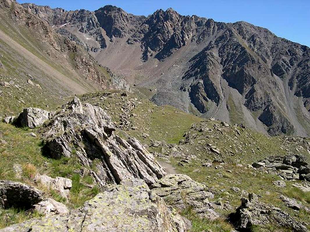
From the lake or from the Upper Station of the Chairlift in crossing with short descent to the West-southwest through the trail n° 19C, concurrent to the farm dirt road, you reach the crossroads in 2.271, 2.231, 2.190 meters (these points you can get directly from Pila with various trails near the ski slope passing by La Chateleine, La Pera and La Nouva) where in a Southerly direction starts the path n°22/TVC to the Plan de l'Eyvie (E/F; 0h'35; 1h'30/2h'00 directly by Pila). From this, still using the same path, after passing a small grassy promontory with a loop under the Northwest Ridge of Mont Bellefaçe, and recovering this direction you reach the altitude 2.382 meters, the Torrent de Plan de l'Eyvie and a small spring. Here the trail flexes slightly more towards the South-southeast, and with the path is not always well evident is brought into a small valley stony and scree with greyish blocks scattered that, with a final in diagonal to the left progressively increasing steepness, reaches the hill just to the left of the Tip of Tsa Setze (2.824/6m) as well as at the beginning of "Via Ferrata" on the West-southwest Ridge of Punta della Valletta (E/F; 1h'20 by Upper Station Chamolé; 3h'00/3h'30 from Pila).
Third stage: the descent from Col Tsa Sètze towards the Arpisson Vallon and Epinel or Gimillan Hamlets in Cogne Valley
From the hill (if desired in a short time there and back you can easily climb through a small track on watershed and a little rock and blocks the nearby Punta Tsa Setze round trip; E/F; 0h'15/0'20) descend to Southeast with the trail No. 2A reaching the Saddle 2.777 meters placed at the Northern margin of small Tip Tsavanis (2.816m; same considerations above) and from the small vallon that is located at the foot of the Valletta and Pian di Bessey Tips until you reach the junction immediately preceding the Pasture of Arpisson (2.328m; E/F; 1h'10 downhill). From this two possibilities of descent to the valley floor, reaching the Hamlets of Epinel (in South) or Gimillan (Southeast): a) - go down by the trail n° 2 reaching, after fording Arpisson Torrent, Tsavanis and (1.859m) Teuvre Alps (1.792m), then Epinel (E/F; 2h'00 by Arpisson; 3h'30 from hill). b) - from Alpe leave on the right (West) the path to Epinel and head instead to Southeast towards a wooden walkway over the Torrent Arpisson; following a long diagonal footpath n° 3/TVC that leads to small Saddle 2.264 meters at the foot of what are called "Cornass Arpisson" at the end of the Southwestern Ridge of Punta di Arpisson (3.035/6m). From here, turning more to the East and increasingly through the same path, through a series of small valleys facing South until you reach a wooded-rocky promontory where the trail begins to descend more steeply. Now, going down into the forest and leaving on the left (Northeast) trail n° 3B toward Tsaplana (2.681m), you reach Pian di Teppe Pastures (1.923m), neighboring a next small votive Chapel of year 1926, the Park Games and then Gimillan (1.787m; E/F; 1h'00/1h'15 from Arpisson).
Prendiamo ad analizzar più nel dettaglio la "nostra" traversata da Nord a Sud, ovvero dalla Conca di Pila al Col Tsa Sètze e discesa all'Arpisson in Val di Cogne.
Prima parte: varie possibilità per raggiungere il Lago di Chamolé e quindi il Plan de l'Eyvie sulla rotta verso il Col Tsa Sètze
Potete raggiungere il Lago di Chamolé (2.325 m), sotto la Testa Nera (2.820 m) nonché subito ad Oriente della Stazione d'arrivo della Seggiovia omonima (2.311 m). L'utilizzo di questa e relativa traversata ad Oriente tramite comoda mulattiera é una meta rivolta alla massa, mentre invece risalendo il valloncello soprastante l'Alpe di Chamolé si effettua una splendida Passeggiata-Escursione. Tre sono le possibilità:
1) - arrivati all'alpe diroccata di Chanté, invece di raggiungere quella di Chamolé, si continua direttamente verso Sud per mezzo di un evidente sentiero non numerato che, in mezzo al Bois Jardin du Public e tra ampie distese di campi di violette, raggiunge la mulattiera di cui sopra a non molta distanza dal lago.
2) - raggiunta l'Alpe di Chamolé si sale alla soprastante presa dell'acqua, subito dietro alla fontana, e con il sentiero n° 14/19A/102 e percorso quasi parallelo al precedente si raggiunge il medesimo.
3) - Oppure ed ancora più ad Est tramite il sentiero n° 19 che, passando al di sotto dello spartiacque col Comboé ed il Segnal Sismonda, raggiunge l'emissario dello stesso, proprio nel punto dove si dipartono le diramazioni per il Colle di Chamolé a Sud (2.641 m; verso il Rifugio di Arbolle 2.516 m) ed i due Colli Sud e Nord di Replan. Altre opzioni per raggiungere il lago sono rappresentate dal sentiero n° 19B, che da Pila-Gorraz Dèsott (1.930 m), dopo una traversata ad Est, sale all'interno del Bois de Chanté passando al di sotto della Seggiovia; oppure più ad Occidente ma tramite giri ben più larghi con i sentieri n° 19C/22 in genere concomitanti o vicini alle piste da sci "del Bosco o Renato Rosa, dei Fagiani o della Nouva". Le sconsigliamo perché o troppo ripide o decisamente "dispersive" costringenti a salite faticose oppure troppo fuori della linea ideale di salita, anche se si posson dalle stesse avere ulteriori esperienze per conoscere più a fondo l'intera Area di Pila nella parte medio-alta. Dal Centro Turistico più frequentato infatti si "aprono" grandi foreste verso Occidente, esageratamente attraversate nella parte più elevata da troppi impianti di risalita atti alla pratica dello Sci e percorse da un numero eccessivo di strade poderali rispettivamente raggiungenti la Punta del Couiss (2.611m), nonché gli alpeggi di montagna insino alla quota media di 2.200/300 metri circa. Una gita "classica" ed abbastanza frequentata é quella che, tramite partenza dalla Stazione Superiore della Funivia di Chamolé in diagonale a Sudovest tramite la strada poderale concomitante con il sentiero n° 19C/TVC, raggiunge in leggera discesa il bivio 2.231 metri, dove arrivano anche le strada poderali provenienti dalle piste da Sci della "Nouva e Leissé". Da questo, volgendo a Mezzogiorno con il sentiero n° 22/TVC, si raggiunge l'Alpe ristrutturata di Plan de l'Eyvie od Eyve (2.253 m; Piano dell'Acqua), situata ai piedi della Cresta Ovest del Mont Bellefaçe, nonché all'inizio del sentiero che conduce al Colle Tsa Sètze (2.815m), tra Conca di Pila e la Valle di Cogne.
Seconda parte: dal Lago di Chamolé o più direttamente verso Plan de l'Eyvie ed il Col Tsa Sètze
Dal lago oppure dalla Stazione Superiore della Seggiovia in traversata con breve discesa verso Ovest-sudovest tramite il sentiero n° 19C, concomitante alla poderale, si raggiungono i bivi 2.271, 2.231, 2.190 metri (a questi punti si può arrivare direttamente da Pila con sentierini vicino alla pista da sci che passa per la Chateleine, La Pera e La Nouva) dove in direzione Sud inizia il sentiero n° 22/TVC per il Plan de l'Eyvie (E/F; 0h'35; 1h'30/2h'00 direttamente da Pila). Da questa, continuando per mezzo dello stesso sentiero, dopo avere superato un piccolo promontorio erboso con un ansa sotto la Cresta Nordovest del Mont Bellefaçe, e riprendendo questa direzione si raggiunge la quota 2.382 metri, il Torrent de Plan de l'Eyvie ed una sorgentina. Qui il percorso flette appena più verso Sud-sudest e con sentiero non sempre ben evidente si porta in una giogaia-macereto con blocchi griastri sparsi che, con un ultimo diagonale verso sinistra in progressivo aumento di ripidità, raggiunge il colle appena a sinistra della Punta di Tsa Sètze (2.824/6 m) nonché all'inizio della "Via Ferrata" sulla Cresta Ovest-sudovest della Punta della Valletta (E/F; 1h'20 dalla Stazione di Chamolé; 3h'00/3h'30 da Pila).
Terza fase: la discesa dal Col Tsa Sètze verso il Vallone di Arpisson ed Epinel o Gimillan in Val di Cogne
Dal colle (volendo in breve tempo tra andata e ritorno si può salire con sentierino e superando una roccetta nel finale la vicina Punta di Tsa Sètze; E/F; 0h'15/0'20) scendere verso Sudest con il sentiero n° 2A raggiungendo la Sella 2.777 metri posta al margine Settentrionale della piccola Punta di Tsavanis (2.816 m; stesse considerazioni della precedente) e da questa il piccolo vallone che é collocato ai piedi delle Punte Valletta e pian di Bessey fino a raggiungere il bivio che immediatamente precede lo Alpeggio di Arpisson (2.328 m; E/F; 1h'10 in discesa). Da questo due possibilità di discesa verso il fondovalle raggiungendo le Frazioni di Epinel (a Sud) oppure di Gimillan (verso Sudest): a)- dall'alpe con piccolo tour a Nordovest e poi decisamente verso Mezzogiorno scendere tramite il sentiero n° 2 raggiungendo, dopo avere attraversato il Torrent de Arpisson, l'Alpe di Tsavanis (1.859 m) e la successiva appena sottostante di Teuvre (1.792 m) e quindi la Frazione di Epinel (E/F; 2h'00 dall'Alpe di Arpisson; 3h'30 dal colle). b)- dall'alpe lasciare a destra (Ovest) il sentiero per Epinel e dirigersi invece a Sudest verso una passerella in legno sopra al Torrent Arpisson; un successivo lungo diagonale tramite sentiero n° 3/TVC conduce alla Selletta 2.264 metri ai piedi di quelli che vengon chiamati "Cornass di Arpisson" al termine della Cresta Sudovest della Punta d'Arpisson (3.035/6 m). Da qui, piegando maggiormente ad Est e tramite sempre il medesimo sentiero, attraversare una serie di piccoli valloncelli esposti a Sud fino a raggiungere un promontorio dove il sentiero prende a calar più ripidamente. Adesso, passando dentro la foresta e lasciando a sinistra (Nordest) il sentiero n° 3B verso la Tsaplana (2.681 m), si raggiunge la località di Pian di Teppe (1.923 m), una successiva Cappellina votiva del 1926, il Parco Giochi e quindi Gimillan Frazione (1.787 m; E/F; 1h'00/1h'15 dall'Arpisson).
Essential Gear
Difficulties
The rating is easy (Hiking or E) or BSA (Ski-Mountaneering) and besides for Expert Trippers (EE), by snowshoes.
Le difficoltà sono da valutare come facile escursione od E oppure gita per Buoni Sciatori Alpinisti (BSA) ed inoltre per Escursionisti esperti (EE) con racchette da neve.
Equipment
Mountaineering equipment, according to season; by Ski or snow's rackets.
Classico da media montagna, secondo la stagione; da Sci-Alpinismo o con racchette da neve.
Mountain Condition
Meteo: you can find all the needed informations at the official site of the Valle d'Aosta Region:


 5922 Hits
 80.49% Score
 12 Votes