
-
 46391 Hits
-
 93.67% Score
-
 44 Votes
|
|
Route |
|---|---|
|
|
45.97690°N / 7.65755°E |
|
|
Mountaineering |
|
|
Summer |
|
|
A long day |
|
|
Alpine AD+ III+ UIAA |
|
|
Overview
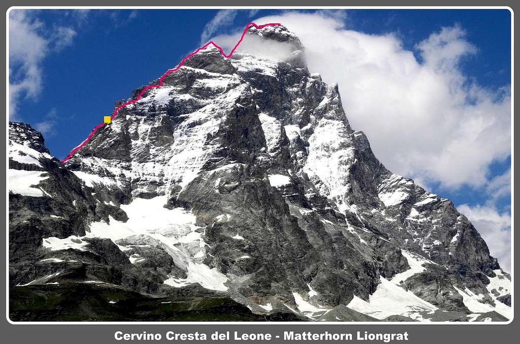
Cresta del Leone – Liongrat or South-West Ridge
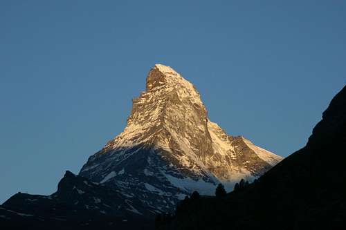
Who doesn’t know Cervino, named Matterhorn on the Swiss side? I limit myself to give a brief description of this world famous 4000s, celebrated by every mountaineer. Check here the complete list of the 82 alpine Fourthousanders and the 46 minor summits: Club4000.
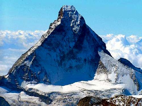
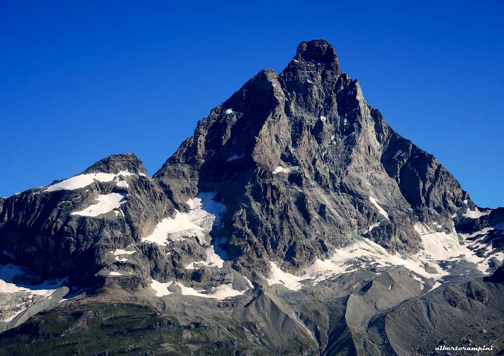
Cervino (Italian name) – Matterhorn (Swiss name) is a perfect pyramid with a quadrangular base, lying in the Pennine Alps and showing four ridges (Hornli, Furggen, Zmutt and Leone), the most natural climbing lines to get the summit, and obviously four faces.
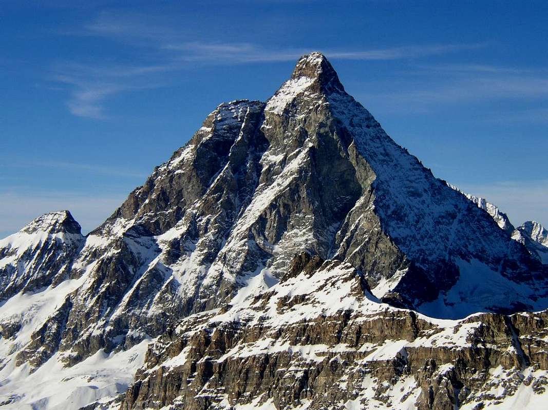
Cresta del Leone, also named "Liongrat“ or "Italian Normal route”, is running on the South-West ridge, overlooking the village of Breuil-Cervinia, lying in the Southern side. It was the route climbed by the second summiters of this tremendous peak and the boundary between Italy and Switzerland runs along it.
At the height of 4241 m. it shows a sharp shoulder named Pic Tyndall, in honour of the British mountaineer John Tyndall, who first climbed this minor peak in 1862, during his attempt to the main summit.
History
- Cervino-Matterhorn first ascent: Edward Whymper, Francis Douglas, Charles Hudson, Douglas Hadow, Michel Croz, and two Zermatt guides, Peter Taugwalder and his son - July 14, 1865 via the Hornli Ridge
- Cresta del Leone-Liongrat first ascent: Jean Antoine Carrel and Jean Baptiste Bich, July 16 and 17, 1865
- Cresta del Leone-Liongrat first winter ascent: Vittorio Sella with the Cervinia guides Jean Antoine, Jean Baptiste and Louis Carrel in 1882
Nowaday the route usually climbed follows the important upper variant, climbed by J.J Maquignaz and J.P. Maquignaz in 1867 during the first repetition of the original route.

|
|
Getting There
The starting point to climb is the village of Breuil-Cervinia (Valtournenche Valley, Italian side), lying at the end of Valtournenche Valley.
Getting to Breuil – Cervinia
- From Turin and Milan: follow the A5 Motorway and exit at Chatillon (Aosta East). Follow the road 406 rising along the Valtournenche Valley, reaching Antey Saint André, Valtournenche and finally Breuil-Cervinia m. 2006 (27 km. from Chatillon).
- From France: you can reach Aosta through Mont Blanc Tunnel or Little St. Bernard Pass, then follow the road 406 running in Valtournenche to Breuil-Cervinia (27 km. from Chatillon)
- From Switzerland: you can reach Aosta through the Great St.Bernard Tunnel or the Great St.Bernard Col, then follow the road 406 running in Valtournenche to Breuil-Cervinia (27 km. from Chatillon)
")
|

|
Walking Approach
Cross Breuil-Cervinia 2006 m and park the car at the end of Via Bich. Take a track on the left that leads to an unsurfaced road. Follow the road past the Capanna degli Alpini and continue to the private hut Rifugio Oriondé - Duca degli Abruzzi 2802 m. It’s possible to take a taxi service to get the hut, otherwise the approach by walk requires about 2,30 hours. Another possibility is to take the first stretch of the Plateau Rosà cable-car until Plan Maison 2550 m. From here take the path to the hut (1 hour).
Cresta del Leone - Liongrat route report

Cresta del Leone - Liongrat report - UIAA Scale
Summit altitude: 4478 m
Difficulty: Alpine AD+, III UIAA, IV UIAA without use the fixed ropes, 45° ice-slopes
Difference in level: 650 m from Capanna Carrel, 1675 m from Rif. Duca degli Abruzzi
Equipment: fixed ropes and chains, stairways, pegs along the pitches
Exposure: SW
First ascent: Jean Antoine Carrel and Jean Baptiste Bich, 1865, july 16th and 17th - Upper section J.J Maquignaz and J.P. Maquignaz 1867, september, 13th
Huts: Rifugio Duca degli Abruzzi 2802 m, Capanna Carrel 3830 m
Starting point: Breuil-Cervinia 2006 m
This route, running on the SW boundary ridge, is more difficult than the NE ridge, or Hornli ridge, on the Swiss side. Even if aided by several fixed gears (ropes, chains and stairways) and the difficulty doesn’t exceed the III grade UIAA (using the fixed gears), this ascent isn’t to be taken lightly, due to the length of the ascent, the altitude, the frequent presence of ice and snow, and the meteorological adversities, particularly sudden and strong even in summer, about which Cervino is quite famous.
Good conditions of the mountain and very good meteo-forecasts are strongly required for a safe climb.
***Part I - Walking from Breuil - Cervinia m. 2006 to Rifugio Duca degli Abruzzi m. 2802
An unsurfaced road, about 6 km. long, rises to Rifugio Oriondé - Duca degli Abruzzi m. 2802, open in summertime season . By foot the time required is about 2 hours and a half. It’s possible to take a taxi service to get the hut, otherwise the approach by walk requires about 2,30 hours. Another possibility is to take the first stretch of the Plateau Rosà cable-car until Plan Maison 2550 m. From here take the path to the hut (1 hour).
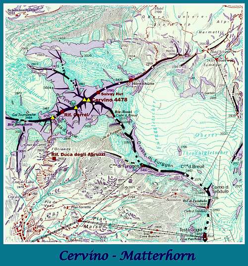
***Part II - Scramble approach from Rifugio Duca degli Abruzzi m. 2802 to Colle del Leone m. 3581
From the hut follow an obvious path heading NW, rising on a first rocky step below the Grand Escalier del Leone (cairns). Climb it on wide ledges and steps reaching the Carrel Cross m. 2920. Climb the rocks on which the cross is lying, heading towards the bottom of an obvious gully. Climb it easily (short fixed rope) to a scree terrace, then to a steep snow-field lying below the characteristic prominence on the SW boundary ridge named Testa del Leone (Lion’s Head). Gain the bottom of Testa del Leone, skirt it towards right (East), traverse on scree slopes alternating with snowy slopes, then follow a ledges-system getting to the saddle named Colle del Leone (Lion’s Col) m. 3581, below the SW ridge. 2,30 hours from Rifugio Duca degli Abruzzi.
***Part III - Climbing section from Colle del Leone m. 3581 to Rifugio Carrel m. 3830
The col is the starting point of the climb on the SW ridge of Cervino. The route runs mainly direct on the ridge, heading sometimes on the South side of the ridge and rising at first on snow slopes, then climbing an upper rocky section, with characteristic passes aided by fixed ropes and chains: the Seiler Slabs, often iced or snow covered, then some steps and a small corner leading to the bottom of a steep wall, what now remains of the famous corner, named Cheminée, entirely fallen down in the summer 2003. Climb the strenuous wall (fixed ropes), then an easier corner, an ice-gully and a snow slope reaching Rifugio Carrel m. 3830, quite an eagle’s nest on the way to the summit. The hut is lying on a terrace along the ridge at the height of 3830 m., below a steep tower named Grande Tour (50 beds, cooking gears). 1 and a half hour from Colle del Leone. It’s quite convenient an overnight stay in the hut, also to keep a better acclimatization. Reservations are mandatory from summer 2019 (info@guidedelcervino.com).

|

|
***Part IV - Climbing section from Rifugio Carrel m. 3830 to the Italian summit m. 4476 and to the Swiss summit m. 4478
Get the scree terrace behind the hut, where it was situated the Capanna Luigi Amedeo, at the bottom of Grande Tour. Start to climb the wall on the S side of Grande Tour and a small overhang, aided by the fixed ropes (“Corda della Sveglia”, III+), then follow a rocky step and small ledges, skirting Grande Tour on the South side (right). Head slanting left, (fixed ropes), then rightward again up to a narrow notch, leading into a rocky basin named Vallon des Glacons, often ice-covered. Traverse it slants to right about 30 meters with the aid of some fixed ropes, getting a 25 m chimney. Climb the chimney (fixed ropes), exit it and climb about 30 meters on slabs and ledges (II+), getting a gully. Climb the gully, gaining the Grande Tour summit ridge, showing numberless small pinnacles, named Crête du Coq (Cockscomb). Don’t climb the pinnacles, but bypass these latters keeping on the South side (right) and following easy ledges. After this stretch climb up to the ridge, getting a notch. Climb Placche Cretier and ignore the next prominence on the ridge traversing rightward to get a narrow, arcing shot and exposed ledge, named Mauvais Pas. Cross the ledge with a delicate move (III) and gain the bottom of a smooth rock: the Rocher des Ecritures, on which is visible the signature of the pioneers.

|
")
|
Slightly downclimb towards the base of the Linceul, a steep snow slope. Climb it on its left edge (fixed ropes), getting to a rocky outcrop. Skirt it on the right, then definitely climb up towards the summit ridge heading to the base of the 30 meters high corner (tombstone), the Grande Corde or Corde Tyndall, steep but aided by chains. Climb it strenuously (III+), getting again the summit ridge at 4080 m. Follow the smooth sloping slabs on the ridge (I-II), one of the most dangerous portion of the whole route when iced, keeping on the Swiss side (North). Cross the Cravate, a wide horizontal ledge on the Italian side (South), often snow-covered. Follow the dizzy ridge again, gaining the summit of the great shoulder named Pic Tyndall m. 4241. 3 hours from Rifugio Carrel. Here is quite visible the upper part of the route, climbing the imposing Testa del Cervino, and the impressive Scala Jordan (Jordan Stairway). Follow the narrow horizontal ridge named Cresta Tyndall about 200 m. long, with snowy portions and two rocky towers. Rappel 10 meters to reach the Enjambée, a narrow notch between Pic Tyndall and Testa del Leone. From the notch traverse to the opposite wall, climb a snow-gully and follow a ridge getting a wide ledge below a steep wall. Traverse rightward skirting the wall, then return left climbing a small sloping corner. Mixed terrain and some rocky steps lead to a narrow terrace named Col Félicité, tribute to Félicité Carrel, the first woman getting this point in 1867. Now it starts the climb on Testa del Cervino, the summit peak.

|

|
Climb to the left of the ridge, reaching a narrow ledge, from which it's visible a new succession of fixed ropes. Traverse the ledge to the right, reaching the first fixed rope, Prima Corda della Testa. After the rope, traverse slanting right on easier ground, then up the second fixed rope along a wide slab, gaining the bottom of the impressive Scala Jordan. Up the stairway (12 steps) overcoming a small overhang, then continue along the fixed ropes: at first the Corda Pirovano along a smooth slab, then another one allowing to traverse left on a sloping slab, the Gite Wentworth. Return on the ridge and follow the fixed ropes on the left, then again come back on the right side on a narrow ledge, Pass Thioly. Climb the ending snow-covered rocks, gaining the Italian summit m. 4476. 4-5 hours from Rifugio Carrel. The Swiss summit m. 4478 is lying on the exposed ridge beyond the Italian summit. Downclimb to a notch (iron cross), then follow the 60 meters exposed ridge, usually snow-covered, gaining the Swiss summit, the highest (10 minutes from the first summit). 5-6 hours from Rifugio Carrel.

|

|
Descent

Descent – Two possibilities:
- downclimbing the same route (possible various abseils on anchors in place)
- another descent is possible by downclimbing on the NE Ridge (Hörnli Ridge) on the Swiss side, aided by an emergency bivouac at the height of 4003 m. (Solvay Hut) and another hut at 3260 m. (Hörnli Hut). This option allows to do the complete traverse of the mountain, a great outing! The descent on the Swiss side along the Hörnli ridge has the advantage of taking place on easier terrain (lower difficulties, but don't underestimate this descent), but the disadvantage of not knowing the route, not having climbed it uphill. Another disadvantage is not to descend to the same starting point. Reached the Hörnli Hut, the itinerary descends to the Schwarzsee, from where you can reach Breuil-Cervinia, the starting point, with the lifts up to the Klein Matterhorn and then by foot to the Testa Grigia, where you find the lifts to Cervinia on the Italian side.
Essential gear
Ropes (better 2x60 m. for rapping), helmet, ice-axe, crampons, a couple of friends, slings, ten quickdraws.
Cervino - Matterhorn views
|

|

|
")
|

|
Red tape
No particulary restrictions
When to climb
Best season goes from the end of July to the middle September
Meteo
Meteo Regione Valle d'Aosta
Meteoswitzerland
Guidebooks and maps

NEW GUIDEBOOK
"Cervino - Valtournenche and Valle Saint Barthelemy" - Andrea Greci - Federico Rossetti (Vie Normali Valle d'Aosta series) - IDEA MONTAGNA2019
 |
 |
 |
 |
 |
Guidebooks
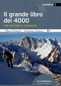
"Il grande libro dei 4000 - Vie normali e classiche" by Marco Romelli, Valentino Cividini - Idea Montagna Editore, 2015
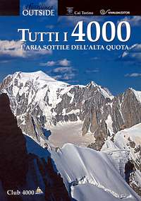
“Tutti i 4000” – L’aria sottile dell’alta quota” – CLUB 4000 CAI TORINO – Vivalda Editori
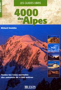
“The 4000 of the Alps” by Richard Goedeke (CAAI) – All the normal routes to the 4000m. summits of the Alps – Libris Edition
“I Quattromila delle Alpi” by Karl Blodig and Helmut Dumler – Zanichelli Editore
“Alpi Pennine Volume 2“ by Gino Buscaini - Guide dei Monti d'Italia C.A.I.-T.C.I.
Map Kompass n° 87, Breuil-Cervinia - Zermatt, scala 1:50.000