
-
 8069 Hits
-
 76.66% Score
-
 7 Votes
|
|
Fact Sheet |
|---|---|
|
|
Aosta |
OVERVIEW INTERVIEW with the HELL
PREAMBLE
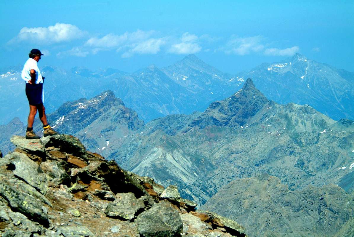
You look over there, far to the South-east and see endless mountain ranges, which run from the Aosta Valley to the Piedmont, the River Po Valley and then the Sea. From the Summit of Emilius I saw it. It was the Dawn of January 5, 1975 and shone confused between a "sea of clouds". On the other side the view was lost to the Dolomites, with the Tofana of Rozès ahead with its South Face pale yellow, where they were born the first nuances of the Morning. Also from Tersiva you see the Ligurian Sea, but I've never had this Fortuna. You can not have Everything in Life, but almost everything. In spite of the Devil and Hell which is thought to dwell on these immaculate Summits. We go to the search: we'll see if it corresponds to Reality.
The chains are aligned parallel so drawn in by Mother Nature Millions of years, the rivers flow downstream recording them every day, and the rocks crumble under the heat and ice of winter. A cycle lord, carefully observing and passion, opens like a book in the reading desk, making you back in the past and, at the same time, projecting yourself into the future. With a little Fantasy you'll see the logical and natural evolution of these mountains up to that they will merge with the Sea.
But it is not a design Infernal, but a Wheel of Time which is screwed onto itself the Infinite ...
^ From Emilius Group to Groups & Subgroups of Southeastern Graian Alps, with Northwestern View, by Osw
You look over there, far to the South-east and see endless mountain ranges, which run from the Aosta Valley to the Piedmont, the River Po Valley and then the Sea. From the Summit of Emilius I saw it. It was the Dawn of January 5, 1975 and shone confused between a "sea of clouds". On the other side the view was lost to the Dolomites, with the Tofana of Rozès ahead with its South Face pale yellow, where they were born the first nuances of the Morning. Also from Tersiva you see the Ligurian Sea, but I've never had this Fortuna. You can not have Everything in Life, but almost everything. In spite of the Devil and Hell which is thought to dwell on these immaculate Summits. We go to the search: we'll see if it corresponds to Reality.
The chains are aligned parallel so drawn in by Mother Nature Millions of years, the rivers flow downstream recording them every day, and the rocks crumble under the heat and ice of winter. A cycle lord, carefully observing and passion, opens like a book in the reading desk, making you back in the past and, at the same time, projecting yourself into the future. With a little Fantasy you'll see the logical and natural evolution of these mountains up to that they will merge with the Sea.
But it is not a design Infernal, but a Wheel of Time which is screwed onto itself the Infinite ...
 |
PREAMBOLO
Tu guardi, laggiù, lontan verso il Sudest e vedi un'infinità di catene montuose, snodantesi dalla Valle verso il Piemonte, la Pianura Padana e poi il Mar. Dalla Vetta dell'Emilius l'ho visto. Era l'Alba del 5 di Gennaio 1975 e brillava confuso tra un "mare di nuvole". Dall'altra parte la vista si perdeva fino alle Dolomiti, con la Tofana di Rozès in evidenza colla sua Parete Sud color giallo pallido, ove nascevano le prime Nuances del Mattino. Anche dalla Tersiva si vede il Mar Ligure, ma io non ho mai avuto la Fortuna. Non si può aver Tutto dalla Vita, ma quasi tutto si. A dispetto del Diavolo e dell'Inferno che, par, abitino su quest'immacolate Vette. Andiam cercando: vedrem se corrisponde a Realtà.
Le catene si allineano parallele, così tracciate in Milioni di anni da Madre Natura, i fiumi scorron a valle incidendole ogni giorno di più, le rocce si sgretolano sotto la calura ed il ghiaccio dell'inverno. Un ciclo Eterno che, osservando con attenzione e passione, si apre come un libro nel leggio, facendo rientrare te nel tempo passato e, nello stesso momento, proiettando te nel futuro. Con un poco di Fantasia vedrai la logica e naturale evoluzione di questi monti fino a che gli stessi si fonderanno con il Mare.
Ma non é un disegno Infernale, bensì una Ruota del Tempo che si avvita su se stessa all'Infinito ...
From Emilius Group to Groups & Subgroups of Southeastern Graian Alps, with Northwestern View, by marco87
Tu guardi, laggiù, lontan verso il Sudest e vedi un'infinità di catene montuose, snodantesi dalla Valle verso il Piemonte, la Pianura Padana e poi il Mar. Dalla Vetta dell'Emilius l'ho visto. Era l'Alba del 5 di Gennaio 1975 e brillava confuso tra un "mare di nuvole". Dall'altra parte la vista si perdeva fino alle Dolomiti, con la Tofana di Rozès in evidenza colla sua Parete Sud color giallo pallido, ove nascevano le prime Nuances del Mattino. Anche dalla Tersiva si vede il Mar Ligure, ma io non ho mai avuto la Fortuna. Non si può aver Tutto dalla Vita, ma quasi tutto si. A dispetto del Diavolo e dell'Inferno che, par, abitino su quest'immacolate Vette. Andiam cercando: vedrem se corrisponde a Realtà.
Le catene si allineano parallele, così tracciate in Milioni di anni da Madre Natura, i fiumi scorron a valle incidendole ogni giorno di più, le rocce si sgretolano sotto la calura ed il ghiaccio dell'inverno. Un ciclo Eterno che, osservando con attenzione e passione, si apre come un libro nel leggio, facendo rientrare te nel tempo passato e, nello stesso momento, proiettando te nel futuro. Con un poco di Fantasia vedrai la logica e naturale evoluzione di questi monti fino a che gli stessi si fonderanno con il Mare.
Ma non é un disegno Infernale, bensì una Ruota del Tempo che si avvita su se stessa all'Infinito ...
 |
COMMENTS TOPOGRAPHICAL and GEO-HISTORICAL NOTES
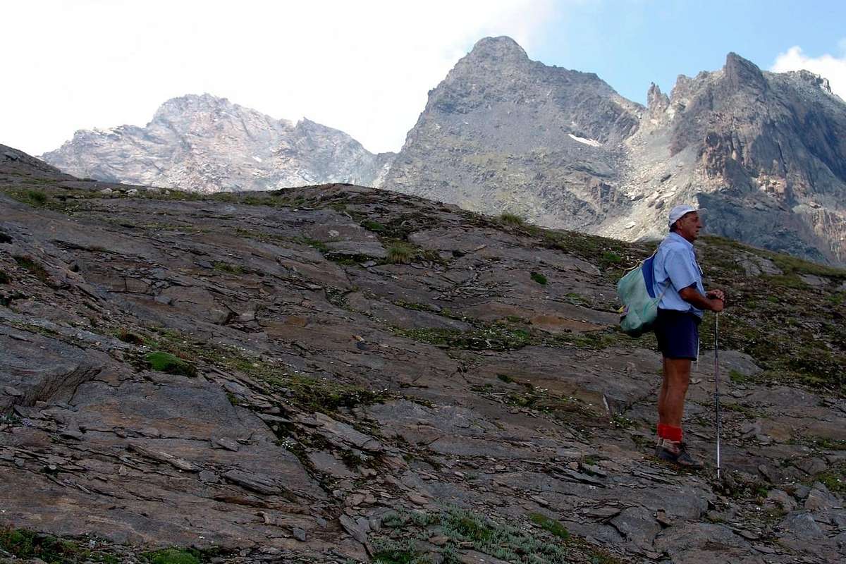
This Third Part , as we had already anticipated in CURTAIN VII°, is directed to that sector in most Southeast of Mount Emilius, in a very large area belonging Graian at the Southeast, and the same holds all the valleys and in the walloons of the South River Baltea, beginning to the West by the Municipality of Aymavilles and arriving at Pont Saint Martin, where does the Eastern boundaries of Vally of Aosta. It also includes the great Valley of Champorcher that , starting from the Central Valley in Bard (very famous Fortress who arrested the march of Napoleon for 16 days in the Italian Campaign, recently restored to visit, absolutely) stretches from the Northeast to the Southwest to meet the boundaries with the Piedmont Region and to join the Cogne Valley via the Saddle of Peradzà and the Hills Window Champorcher and Ponton, all facing the High Urtier Walloon. This stream is up to Lillaz with beautiful waterfalls and then joins the Torrent Grauson East entrance of Cogne and Valnontey to the opposite side, forming the River Grand'Eyvia or Great Water, in turn, flows to the Northwest rejoining the Baltea at Aymavilles, defining in such a way and circularly this great area. The Torrent Urtier is also the limit of the Gran Paradiso National Park (P.N.G.P.), which by the Dora di Rhêmes reaches here, the natural , rather logically, extends much further in the distance and, ideally, in the future we see the conjunction of this with the Hunting Reserve Turati, a former Reserve the Baron Beck Peckoz, to the North and the unification of the Natural Reserve Park of Mount Avic, among other things, not far away, in the Northeast. The Champorcher Valley is in turn divided into two parts by the Ayasse Torrent: one to the North by the watershed that Peradzà/Costazza/Ponton/Pontonnet is directed to Tersiva/Moutsaillon/Delà/Glacier/ Gran Rossa/Cima Piana and Eastern appendices; a second, in the South, to Asgelas/Rosa of Banchi/Nero/Mars/Corni. In addition, other savages parallel walloons descend to the Towns of Pont Bozet, Bard, Donnas and Pont Saint Martin arriving perpendicular to Baltea and the "Lower" Valley. The ridge dividing the Piedmont aligns with Corni/Arbueil/Tre Denti/Dondogna/Debat/Valletta/Andelmel/Strie/Bonze and Cima della Battaglia to finally sloping with elevations less and less towards the Plain of Ivrea, with its large moraine, called The Serra, the front of the Great Glacier Balteo that the Ice Age, down from Mount Blanc here to finish his "race".
Of this arc of mountains, vast sector as still limited since Graie extend from the Cozie Alps Pennine Alps therefore including the Groups of Gran Paradiso, Sassière, Rutor and Chain of Mount Blanc, the Graie of Southeast or, even Eastern , as in: "Scrambles in the Eastern Graians" of Gerorges Yeld, Edit. Fisher Unwin, London, 1900 is still very little is talked about and even less written. Aside from some occasional observation of magazines, you have to wait "Guida delle Alpi Occidentali" C.A.I. Turin, 1896 and 1889, by Giovanni and Luigi Bobba Vaccarone to experience one careful study of organic and geographically structured. Mountains always neglected and voluntarily excluded from the "Gran Paradiso", 1939, 1963 and 1980, by Renato Chabod in the Series of Mounts of Italy, which stopped at the Arietta's Hill, have been partially addressed in the "Guida del Monte Emilius", 1978 and in "Emilius Rosa dei Banchi Parco del M.Avic", by Giulio Berutto and Lino Fornelli in 2005, always in the same necklace.
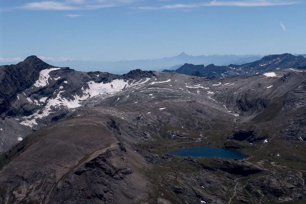
From Tersiva Group towards Mount Delà, Fussì Hill & Mount Glacier Subgroup, with West-southwestern View, by Antonio
This Third Part , as we had already anticipated in CURTAIN VII°, is directed to that sector in most Southeast of Mount Emilius, in a very large area belonging Graian at the Southeast, and the same holds all the valleys and in the walloons of the South River Baltea, beginning to the West by the Municipality of Aymavilles and arriving at Pont Saint Martin, where does the Eastern boundaries of Vally of Aosta. It also includes the great Valley of Champorcher that , starting from the Central Valley in Bard (very famous Fortress who arrested the march of Napoleon for 16 days in the Italian Campaign, recently restored to visit, absolutely) stretches from the Northeast to the Southwest to meet the boundaries with the Piedmont Region and to join the Cogne Valley via the Saddle of Peradzà and the Hills Window Champorcher and Ponton, all facing the High Urtier Walloon. This stream is up to Lillaz with beautiful waterfalls and then joins the Torrent Grauson East entrance of Cogne and Valnontey to the opposite side, forming the River Grand'Eyvia or Great Water, in turn, flows to the Northwest rejoining the Baltea at Aymavilles, defining in such a way and circularly this great area. The Torrent Urtier is also the limit of the Gran Paradiso National Park (P.N.G.P.), which by the Dora di Rhêmes reaches here, the natural , rather logically, extends much further in the distance and, ideally, in the future we see the conjunction of this with the Hunting Reserve Turati, a former Reserve the Baron Beck Peckoz, to the North and the unification of the Natural Reserve Park of Mount Avic, among other things, not far away, in the Northeast. The Champorcher Valley is in turn divided into two parts by the Ayasse Torrent: one to the North by the watershed that Peradzà/Costazza/Ponton/Pontonnet is directed to Tersiva/Moutsaillon/Delà/Glacier/ Gran Rossa/Cima Piana and Eastern appendices; a second, in the South, to Asgelas/Rosa of Banchi/Nero/Mars/Corni. In addition, other savages parallel walloons descend to the Towns of Pont Bozet, Bard, Donnas and Pont Saint Martin arriving perpendicular to Baltea and the "Lower" Valley. The ridge dividing the Piedmont aligns with Corni/Arbueil/Tre Denti/Dondogna/Debat/Valletta/Andelmel/Strie/Bonze and Cima della Battaglia to finally sloping with elevations less and less towards the Plain of Ivrea, with its large moraine, called The Serra, the front of the Great Glacier Balteo that the Ice Age, down from Mount Blanc here to finish his "race".
Of this arc of mountains, vast sector as still limited since Graie extend from the Cozie Alps Pennine Alps therefore including the Groups of Gran Paradiso, Sassière, Rutor and Chain of Mount Blanc, the Graie of Southeast or, even Eastern , as in: "Scrambles in the Eastern Graians" of Gerorges Yeld, Edit. Fisher Unwin, London, 1900 is still very little is talked about and even less written. Aside from some occasional observation of magazines, you have to wait "Guida delle Alpi Occidentali" C.A.I. Turin, 1896 and 1889, by Giovanni and Luigi Bobba Vaccarone to experience one careful study of organic and geographically structured. Mountains always neglected and voluntarily excluded from the "Gran Paradiso", 1939, 1963 and 1980, by Renato Chabod in the Series of Mounts of Italy, which stopped at the Arietta's Hill, have been partially addressed in the "Guida del Monte Emilius", 1978 and in "Emilius Rosa dei Banchi Parco del M.Avic", by Giulio Berutto and Lino Fornelli in 2005, always in the same necklace.
 |
OSSERVAZIONI GEO-TOPOGRAFICHE nonché NOTE STORICHE
Questa terza parte, come avevam già anticipato in CURTAIN VII°, é rivolta a quel settore più a Sudest del Monte Emilius, in un'area molto vasta appartenente Alle Alpi Graie di Sudest; la medesima ricopre tutte le valli ed i valloni a Mezzogiorno del Fiume Dora Baltea, iniziando ad Occidente dal Comune di Aymavilles ed arrivando a Pont Saint Martin, dove finiscono i confini Orientali della Valle d'Aosta. Inoltre é comprensiva della grande Valle di Champorcher che, iniziando dalla Valle Centrale a Bard (famosissimo Forte che arrestò la marcia di Napoleone per 16 giorni nella Campagna d'Italia, recentemente ristrutturato; da visitare, assolutamente) s'allunga da Nordest a Sudovest per incontrar i confini con la Regione Piemonte e per unirsi alla Valle di Cogne tramite la Sella di Peradzà ed i Colli Finestra di Champorcher e di Ponton, tutti rivolti all'Alto Vallone dell'Urtier. Questo torrente arriva fino a Lillaz con belle cascate per poi unirsi al Torrent Grauson all'entrata Est di Cogne ed a quello di Valnontey nel lato opposto, formando il Fiume Grand Eyvia o Grande Acqua che, a sua volta, scorre a Nordovest riunendosi alla Dora Baltea presso Aymavilles, delimitando in siffatto modo e circolarmente questa grande area. Il Torrente Urtier costituisce, inoltre, il limite del Parco Nazionale del Gran Paradiso, che dalla Dora di Rhêmes arriva insino a qui; quello naturale, invece logicamente, s'estende molto di più in lontananza e, idealmente, vediamo nel futuro la congiunzione di questo con la Riserva di Caccia Turati, ex Riserva del Barone Beck Peckoz, a Settentrione e l'unificazione con la Riserva Naturale del Parco del Monte Avic, tra l'altro non molto distante, a Nordest. La Valle di Champorcher é a sua volta suddivisa in due parti dal Torrent Ayasse: una più a Nord che dallo spartiacque Peradzà/Costazza/Ponton/Pontonnet si indirizza alla Tersiva/Moutsaillon/Delà/Glacier/Gran Rossa/Piana ed appendici Orientali; una seconda, a Mezzogiorno, verso Asgelas/Rosa dei Banchi/Nero/Marzo/Corni. Oltre, altri selvaggi valloni paralleli discendono verso i Comuni di Pont Bozet, Bard, Donnas e Pont Saint Martin giungendo perpendicolarmente alla Dora Baltea ed alla "Bassa" Valle. La cresta spartiacque con il Piemonte si allinea con i Corni/Arbueil/Tre Denti/Dondogna/Debat/Valletta/Andelmel/Strie/Bonze e Cima della Battaglia per infin digradare con elevazioni sempre minori verso la Pianura di Ivrea, con la sua grande morena, detta La Serra, fronte del Grande Ghiacciaio Balteo che, nell'Era Glaciale, scendeva dal Monte Bianco per qui terminare la sua "corsa".
Di quest'arco di montagne, settore per quanto vasto pur sempre limitato poiché le Graie s'estendono dalle Alpi Cozie alle Pennine comprensive quindi anche i Gruppi di Gran Paradiso, Sassière, Rutor e Catena del Monte Bianco, delle Graie di Sudest od, ed ancora Orientali, come in : "Scrambles in the Eastern Graians" di Gerorges Yeld, Edit. Fisher-Unwin, London, 1900, sempre molto poco si é parlato ed ancor meno scritto. Oltre a qualche osservazione saltuaria su riviste, bisogna attendere infatti "Guida delle Alpi Occidentali" del C.A.I. di Torino, 1896 e 1889, ad opera di Giovanni Bobba e Luigi Vaccarone per riscontrare un'attento studio organico e geograficamente strutturato. Montagne sempre neglette e volontariamente escluse dalla Guida del "Gran Paradiso", 1939, 1963 nonché 1980, di Renato Chabod nella Collana dei Monti d'Italia, che s'arrestava al Colle dell'Arietta, sono state trattate parzialmente in "Guida del Monte Emilius", 1978, ed in "Emilius Rosa dei Banchi Parco del M.Avic" di Giulio Berutto e Lino Fornelli nel 2005, sempre nella medesima collana.
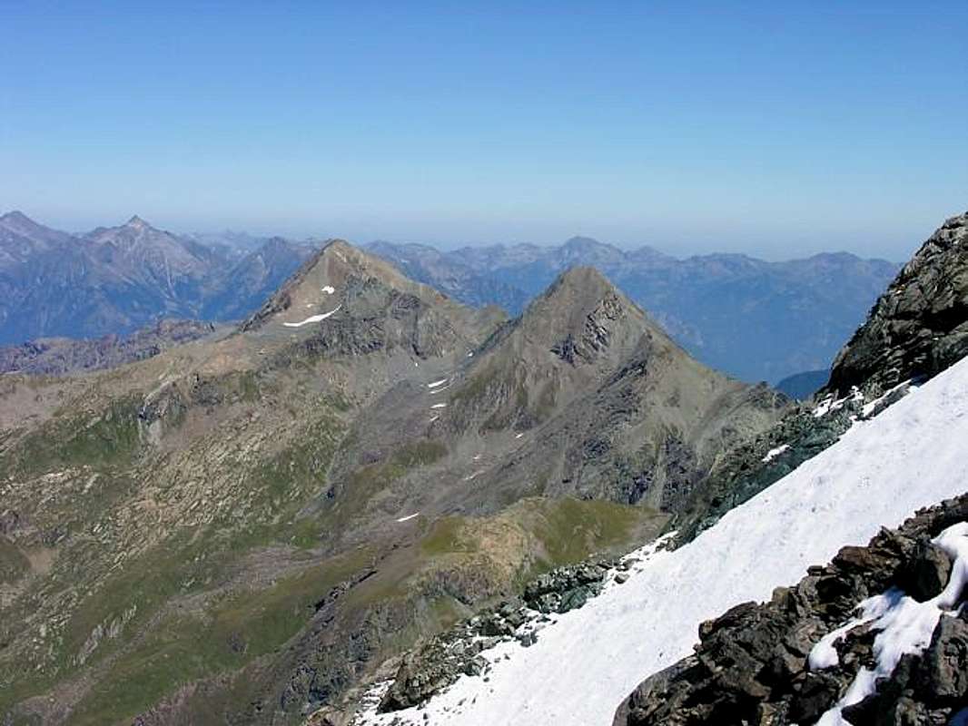
From Tersiva Group to Southeastern Graians and Punta Nera & Lavina's Tower. To the left Arietta Pass, with North-northwestern View, by Antonio
Questa terza parte, come avevam già anticipato in CURTAIN VII°, é rivolta a quel settore più a Sudest del Monte Emilius, in un'area molto vasta appartenente Alle Alpi Graie di Sudest; la medesima ricopre tutte le valli ed i valloni a Mezzogiorno del Fiume Dora Baltea, iniziando ad Occidente dal Comune di Aymavilles ed arrivando a Pont Saint Martin, dove finiscono i confini Orientali della Valle d'Aosta. Inoltre é comprensiva della grande Valle di Champorcher che, iniziando dalla Valle Centrale a Bard (famosissimo Forte che arrestò la marcia di Napoleone per 16 giorni nella Campagna d'Italia, recentemente ristrutturato; da visitare, assolutamente) s'allunga da Nordest a Sudovest per incontrar i confini con la Regione Piemonte e per unirsi alla Valle di Cogne tramite la Sella di Peradzà ed i Colli Finestra di Champorcher e di Ponton, tutti rivolti all'Alto Vallone dell'Urtier. Questo torrente arriva fino a Lillaz con belle cascate per poi unirsi al Torrent Grauson all'entrata Est di Cogne ed a quello di Valnontey nel lato opposto, formando il Fiume Grand Eyvia o Grande Acqua che, a sua volta, scorre a Nordovest riunendosi alla Dora Baltea presso Aymavilles, delimitando in siffatto modo e circolarmente questa grande area. Il Torrente Urtier costituisce, inoltre, il limite del Parco Nazionale del Gran Paradiso, che dalla Dora di Rhêmes arriva insino a qui; quello naturale, invece logicamente, s'estende molto di più in lontananza e, idealmente, vediamo nel futuro la congiunzione di questo con la Riserva di Caccia Turati, ex Riserva del Barone Beck Peckoz, a Settentrione e l'unificazione con la Riserva Naturale del Parco del Monte Avic, tra l'altro non molto distante, a Nordest. La Valle di Champorcher é a sua volta suddivisa in due parti dal Torrent Ayasse: una più a Nord che dallo spartiacque Peradzà/Costazza/Ponton/Pontonnet si indirizza alla Tersiva/Moutsaillon/Delà/Glacier/Gran Rossa/Piana ed appendici Orientali; una seconda, a Mezzogiorno, verso Asgelas/Rosa dei Banchi/Nero/Marzo/Corni. Oltre, altri selvaggi valloni paralleli discendono verso i Comuni di Pont Bozet, Bard, Donnas e Pont Saint Martin giungendo perpendicolarmente alla Dora Baltea ed alla "Bassa" Valle. La cresta spartiacque con il Piemonte si allinea con i Corni/Arbueil/Tre Denti/Dondogna/Debat/Valletta/Andelmel/Strie/Bonze e Cima della Battaglia per infin digradare con elevazioni sempre minori verso la Pianura di Ivrea, con la sua grande morena, detta La Serra, fronte del Grande Ghiacciaio Balteo che, nell'Era Glaciale, scendeva dal Monte Bianco per qui terminare la sua "corsa".
Di quest'arco di montagne, settore per quanto vasto pur sempre limitato poiché le Graie s'estendono dalle Alpi Cozie alle Pennine comprensive quindi anche i Gruppi di Gran Paradiso, Sassière, Rutor e Catena del Monte Bianco, delle Graie di Sudest od, ed ancora Orientali, come in : "Scrambles in the Eastern Graians" di Gerorges Yeld, Edit. Fisher-Unwin, London, 1900, sempre molto poco si é parlato ed ancor meno scritto. Oltre a qualche osservazione saltuaria su riviste, bisogna attendere infatti "Guida delle Alpi Occidentali" del C.A.I. di Torino, 1896 e 1889, ad opera di Giovanni Bobba e Luigi Vaccarone per riscontrare un'attento studio organico e geograficamente strutturato. Montagne sempre neglette e volontariamente escluse dalla Guida del "Gran Paradiso", 1939, 1963 nonché 1980, di Renato Chabod nella Collana dei Monti d'Italia, che s'arrestava al Colle dell'Arietta, sono state trattate parzialmente in "Guida del Monte Emilius", 1978, ed in "Emilius Rosa dei Banchi Parco del M.Avic" di Giulio Berutto e Lino Fornelli nel 2005, sempre nella medesima collana.
 |
KEY reading and interpretation of PAGE
The reading of this page, so as to complete the triptych with CURTAIN VII° addressed to Monte Emilius and X° CURTAIN° to its surroundings, implies a position of acceptance among a mix between serious and humorous, in fact, while dealing with the work and Scientifically premise and also almost always a source or at least Historical Legendary, there have been attempts to "animate" these mountains, then as happens in Reality. It would be a serious mistake to see them only as a heap of rocks and ice (just for the truth in the area), separating them from what has been and still is their Human History. Indeed, as the Universe would not exist if it were not for the Man who observes and studies, similar would happen to the mountains, so as to remain unknown and shapeless Matter. The human work instead discovered them, appointed, popular and valued up to dissect in detail. From the Mont Maudit, or Mount Doom that had to appear to the poor inhabitants underlying to which only provided Fears One has come to the various denominations, generally related to civilization. So for the Matterhorn or the Horn of Matter, Cervino in Italian making it derive from the Latin Servae Mons or of the Forest (but it's all here to discuss because if there is a mountain "worn" on our side and this is certainly in the other Swiss I only see glaciers.'ll talk), the Aiguille de l'E'boulement or of the Landslide, or with names linked to mountaineering feats, such as the Mount Emilius. For still others, the name is lost in the Mists of Time, difficult to interpret as The Grivola, which has become the Jungfrau in the Valley of Aosta or the Rutor also Ruitor, of ancient (Celtic? Also Ru Tort, ie Stream Twisted?) and uncertain denomination.
What small Indiana Jones we seek, but always with a smile and, most importantly, having fun!
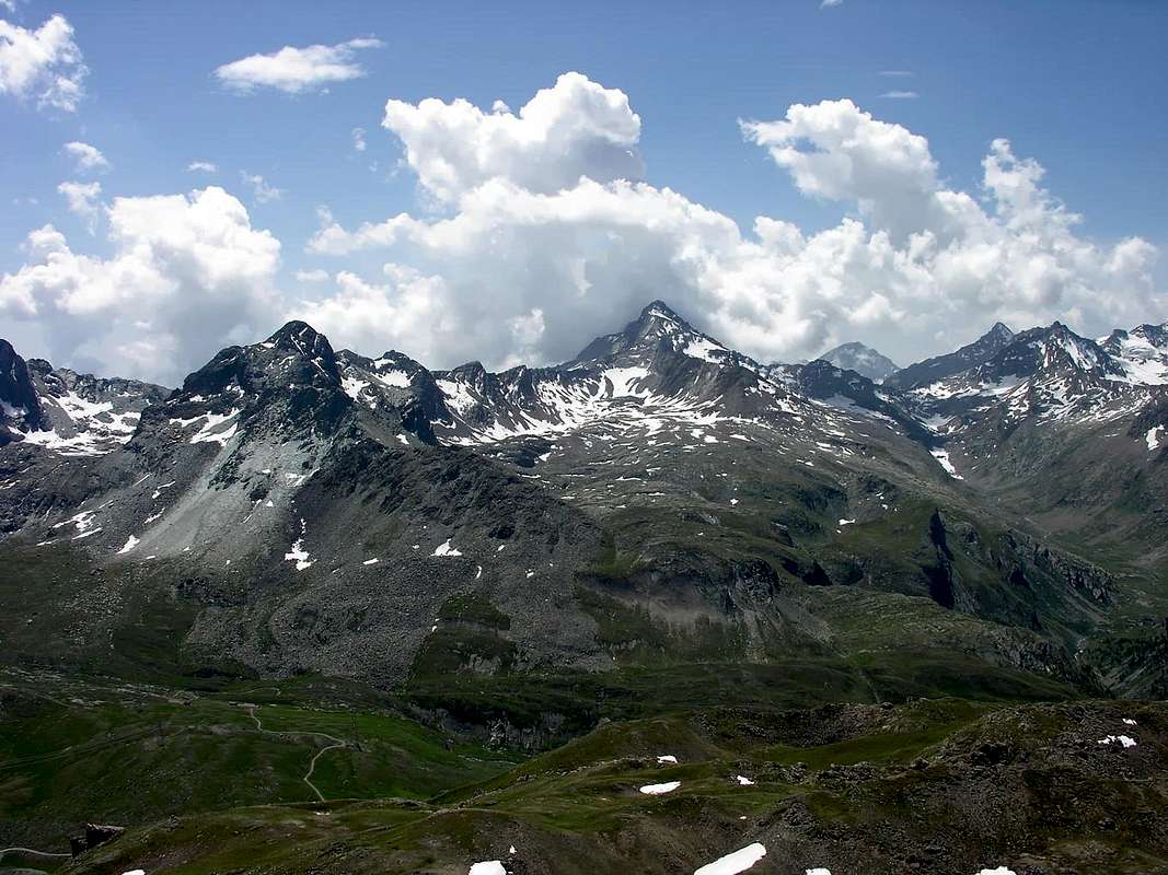
From Mount Glacier Subgroup to Southeastern Graians and Rosa dei Banchi & Monviso in Cottian Alps, with North-northwestern View, by emilius
The reading of this page, so as to complete the triptych with CURTAIN VII° addressed to Monte Emilius and X° CURTAIN° to its surroundings, implies a position of acceptance among a mix between serious and humorous, in fact, while dealing with the work and Scientifically premise and also almost always a source or at least Historical Legendary, there have been attempts to "animate" these mountains, then as happens in Reality. It would be a serious mistake to see them only as a heap of rocks and ice (just for the truth in the area), separating them from what has been and still is their Human History. Indeed, as the Universe would not exist if it were not for the Man who observes and studies, similar would happen to the mountains, so as to remain unknown and shapeless Matter. The human work instead discovered them, appointed, popular and valued up to dissect in detail. From the Mont Maudit, or Mount Doom that had to appear to the poor inhabitants underlying to which only provided Fears One has come to the various denominations, generally related to civilization. So for the Matterhorn or the Horn of Matter, Cervino in Italian making it derive from the Latin Servae Mons or of the Forest (but it's all here to discuss because if there is a mountain "worn" on our side and this is certainly in the other Swiss I only see glaciers.'ll talk), the Aiguille de l'E'boulement or of the Landslide, or with names linked to mountaineering feats, such as the Mount Emilius. For still others, the name is lost in the Mists of Time, difficult to interpret as The Grivola, which has become the Jungfrau in the Valley of Aosta or the Rutor also Ruitor, of ancient (Celtic? Also Ru Tort, ie Stream Twisted?) and uncertain denomination.
What small Indiana Jones we seek, but always with a smile and, most importantly, having fun!
 |
CHIAVE di lettura ed interpretazione della PAGINA
La lettura di questa pagina, tal da completare il trittico con CURTAIN VII° rivolto al Monte Emilius e CURTAIN X° al suo circondario, comporta una posizione d'accettazione tra un mélange tra il serio ed il faceto; infatti, pur trattando Scientificamente il lavoro e premettendo quasi sempre ed altresì una fonte Storica od almeno Leggendaria, s'é cercato di "animare" queste montagne, come poi avviene nella Realtà. Sarebbe un grave errore vederle solamente come un ammasso di rocce e ghiacci (pochi per la verità in zona), separandole da quella che é stata e tuttora é la loro Storia Umana. In effetti, come l'Universo, non esisterebbe se non fosse per l'Uomo che l'osserva studiandolo, similmente avverrebbe per i monti, tali da rimaner sconosciuti ed informi nella Materia. L'opera umana invece li ha scoperti, nominati, frequentati e valorizzati fino a sezionarli nei minimi particolari. Dal Mont Maudit, o Monte Maledetto che tal doveva apparir ai poveri abitanti sottostanti ai quali forniva soltanto Paure, si é giunti alle varie denominazioni, generalmente legate alla civilizzazione. Così per il Matterhorn o Corno di Matter, in Italia Cervino facendolo derivare dal latino Servae Mons o della Foresta (ma qui é tutto da discutere perché s'esiste una montagna "splelacchiata" sul nostro versante é di sicuro questa e negli altri svizzeri io vedo sol ghiacciai. Ne riparleremo), l'Aiguille de l'Eboulement o della Frana o, con denominazioni collegate ad imprese alpinistiche, come il Monte Emilius. Per altri ancora il toponimo si perde nella Notte dei Tempi, difficilmente interpretabile come per La Grivola, che é diventata la Jungfrau della Valle d'Aosta od il Rutor o Ruitor, di antica (Celtica? O da Ru Tort, cioé Ruscello Contorto?) ed incerta denominazione.
Quali piccoli Indiana Jones andiamo alla ricerca, ma sempre con il sorriso sulle labbra e, soprattutto, divertendoci!
From Leppe's Point Subgroup to Eastern Graians with Raye Chevrère Pass (right), Mount Avic, Hill Varotta, Mount Rouvic & Mount Giron, with South-southwestern View, by emilius
Graian ALPS
La lettura di questa pagina, tal da completare il trittico con CURTAIN VII° rivolto al Monte Emilius e CURTAIN X° al suo circondario, comporta una posizione d'accettazione tra un mélange tra il serio ed il faceto; infatti, pur trattando Scientificamente il lavoro e premettendo quasi sempre ed altresì una fonte Storica od almeno Leggendaria, s'é cercato di "animare" queste montagne, come poi avviene nella Realtà. Sarebbe un grave errore vederle solamente come un ammasso di rocce e ghiacci (pochi per la verità in zona), separandole da quella che é stata e tuttora é la loro Storia Umana. In effetti, come l'Universo, non esisterebbe se non fosse per l'Uomo che l'osserva studiandolo, similmente avverrebbe per i monti, tali da rimaner sconosciuti ed informi nella Materia. L'opera umana invece li ha scoperti, nominati, frequentati e valorizzati fino a sezionarli nei minimi particolari. Dal Mont Maudit, o Monte Maledetto che tal doveva apparir ai poveri abitanti sottostanti ai quali forniva soltanto Paure, si é giunti alle varie denominazioni, generalmente legate alla civilizzazione. Così per il Matterhorn o Corno di Matter, in Italia Cervino facendolo derivare dal latino Servae Mons o della Foresta (ma qui é tutto da discutere perché s'esiste una montagna "splelacchiata" sul nostro versante é di sicuro questa e negli altri svizzeri io vedo sol ghiacciai. Ne riparleremo), l'Aiguille de l'Eboulement o della Frana o, con denominazioni collegate ad imprese alpinistiche, come il Monte Emilius. Per altri ancora il toponimo si perde nella Notte dei Tempi, difficilmente interpretabile come per La Grivola, che é diventata la Jungfrau della Valle d'Aosta od il Rutor o Ruitor, di antica (Celtica? O da Ru Tort, cioé Ruscello Contorto?) ed incerta denominazione.
Quali piccoli Indiana Jones andiamo alla ricerca, ma sempre con il sorriso sulle labbra e, soprattutto, divertendoci!
 |
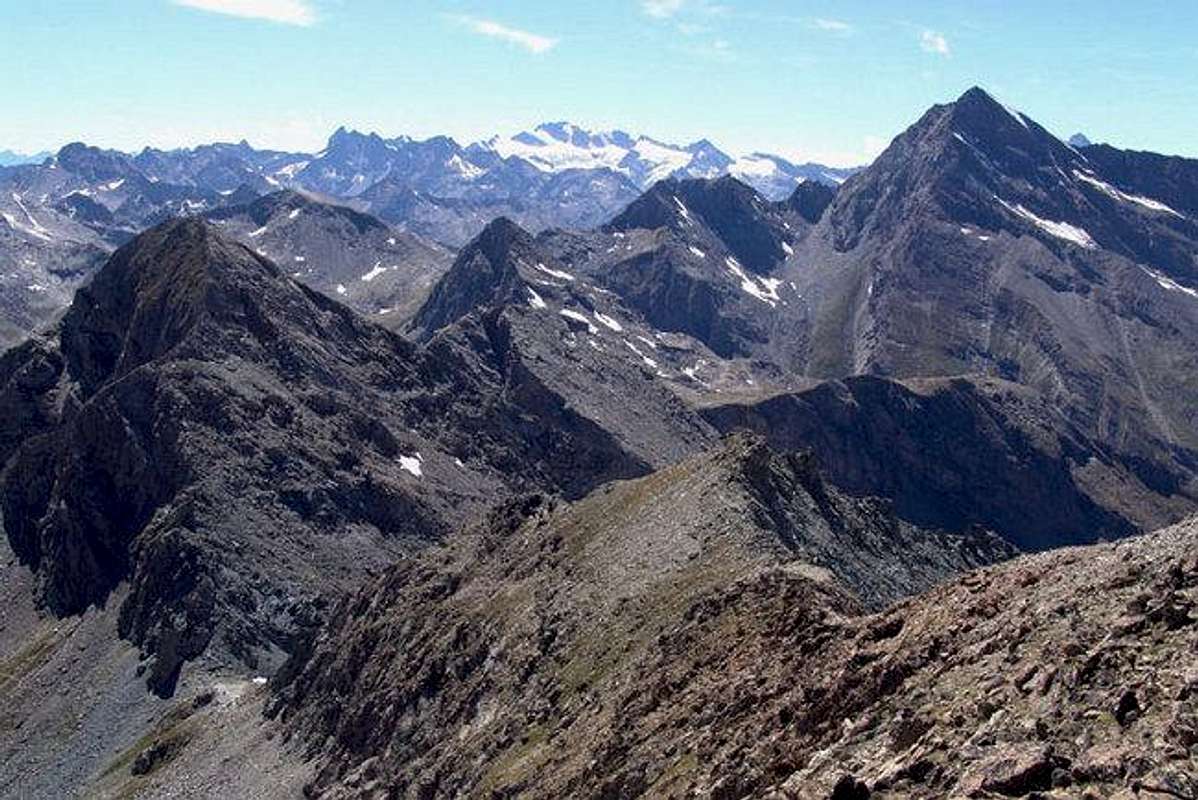
Over that ridge begin to GRAIANS SOUTHEAST
What is the dividing line of Graian of Southeast? Does not exist. The Graian are single chain that extends from the East, ie from Monviso in the Cottian Alpes, in the West, or the Chain of Mount Blanc. Passing through the chains formed from smaller groups to the East and Southeast of the Gran Paradiso Massif, as well as those immediately to the West, so-called Central Graian. But it is an artificial division, useful to better identify Groups, especially in the writing of Mountaineering and Climbing Guides. Keep it, making us also a "manipulation" arbitrary and comfortable. In fact some of these mountains lie even to the North (Emilius, Range Roèses) or at Northeast (Tersiva and branches, Glacier, Rafrey, Avic) compared to the Gran Paradiso, on the other hand many other watersheds are oriented to the East, and progressively in Southeast (Rosa dei Banchi, Corni and Mount Mars). The same continues even further in this direction progressing towards Piedmont, and then go to join the Cottians.
So "our" boundary line begins at the Arietta Pass (2947m), at the end of the long spur which the Tower of Lavina (3308m) down to the Northeast, acting as a divider between the Walloon of Acque Rosse (Red Water) in Aosta Valley and that of Rancio in Piedmont, in addition, after the Testa of the Nouva (3034m), the watershed is coming more to the East coming to the Point Peradzà (3021m) where, just beyond, there is an important node in topographic altitude of 3000 meters about. A branching continues East towards Col de la Balma, Point Corona, Point of th'Asgelas, Rosa's Pass and Rosa of Banchi (3164m), dividing the Champorcher Valley from that of Campiglia in Piedmont, a second is addressed decisively in the North forming the Bec Costazza, Fenetre of Champorcher, Ponton Tower and Pontonnet Hill, these two last steps of the Cogne Valley and the Champorcher. From this the watershed gets up, more to the North-northwest, the Tower Pontonnet culminating in Point Tersiva (3513/4m), this important Summit, second in height only to Mount Emilius (3559m) throughout this vast area, it releases North along a buttress, which divides the Walloons of Grauson-Doreire to the West by the High Comba Tersiva in the Valley Fénis up to Point of Tessonet (3266m). From this the watershed divides: one branch goes to the North forming in succession the Hill of Lavodilec, Petit Avert, Terre Bleue Hill, Grand Avert (2991m), the Grande Cresta or Crest of the Devil, Point Plan Rué, Col Belfrond , Crotey Hill, Mount Corquet, where splits again right towards La Torrasse and Mount Saint Julien, left towards the Mount Roux with its Coppermines and Iron. The second branch instead falls to Northwestern, after the collar Tessonet form the Point Gianni Vert and the two peaks of Laval, and then descend to the Corona's Hill or Saint Marcel (2913m), where he began the Group of Emilius.
This little dissertation is added to distinguish the Emilius Group and its subgroups from those who identify as "Graian Southeast", although some subgroups, as already stated, are located in the East or, indeed, like that of the Mount Avic, to the Northeast. So part of this naming all those mountains on the seaward side of the Hill of Saint Marcel and, returning back but in order to be even more explicit, the Tersiva, the Point Peradzà and Hill of the Arietta.
Also divide, following the fashion of the Ridges and the Lightning who "break" the Infinite, this CURTAIN XI° in three Parts, with relative Pages:
First)-: From the Pass of th'Arietta Tersiva and the two arms towards the Saint Marcel Hill and the Great Avert.
Second)-: From Tersiva to the East to the duo Delà/Glacier and the ramifications to the Mount Rafray ede the Natural Park of Mont Avic.
Third)-: From Peradzà to the Rosa of Banchi and all his great district to the East and Southeast towards Mount Marzo, towards Piedmont.
Of these mountains, paths personally far and wide on several occasions, narrate illustrating not all, of course, but a part of them, those internal to the Valley of Aosta or if neighboring on its side, which left a big mark in our Experiences and Fantasies. Always among the Serious and Playful ...
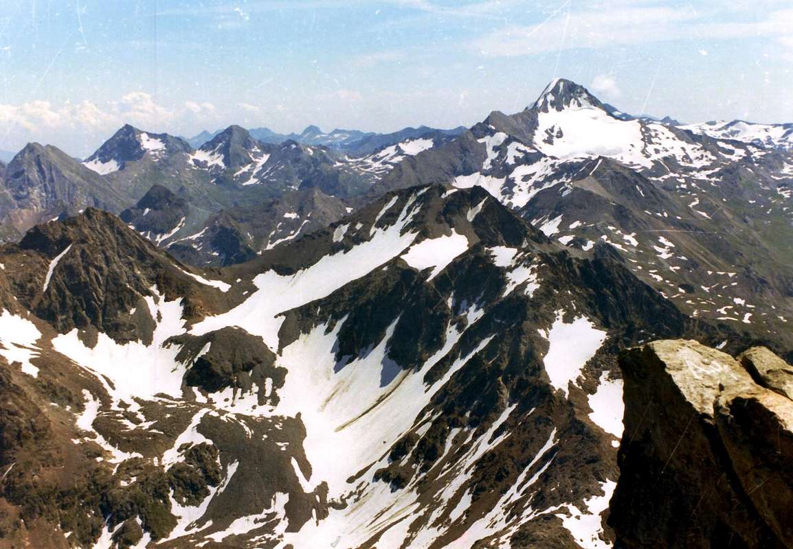
After Leppe Point, and Corona's Lake, Subgroup begin the Eastern Graian, with South-southwestern View, by Osw
ALPI GRAIE
So "our" boundary line begins at the Arietta Pass (2947m), at the end of the long spur which the Tower of Lavina (3308m) down to the Northeast, acting as a divider between the Walloon of Acque Rosse (Red Water) in Aosta Valley and that of Rancio in Piedmont, in addition, after the Testa of the Nouva (3034m), the watershed is coming more to the East coming to the Point Peradzà (3021m) where, just beyond, there is an important node in topographic altitude of 3000 meters about. A branching continues East towards Col de la Balma, Point Corona, Point of th'Asgelas, Rosa's Pass and Rosa of Banchi (3164m), dividing the Champorcher Valley from that of Campiglia in Piedmont, a second is addressed decisively in the North forming the Bec Costazza, Fenetre of Champorcher, Ponton Tower and Pontonnet Hill, these two last steps of the Cogne Valley and the Champorcher. From this the watershed gets up, more to the North-northwest, the Tower Pontonnet culminating in Point Tersiva (3513/4m), this important Summit, second in height only to Mount Emilius (3559m) throughout this vast area, it releases North along a buttress, which divides the Walloons of Grauson-Doreire to the West by the High Comba Tersiva in the Valley Fénis up to Point of Tessonet (3266m). From this the watershed divides: one branch goes to the North forming in succession the Hill of Lavodilec, Petit Avert, Terre Bleue Hill, Grand Avert (2991m), the Grande Cresta or Crest of the Devil, Point Plan Rué, Col Belfrond , Crotey Hill, Mount Corquet, where splits again right towards La Torrasse and Mount Saint Julien, left towards the Mount Roux with its Coppermines and Iron. The second branch instead falls to Northwestern, after the collar Tessonet form the Point Gianni Vert and the two peaks of Laval, and then descend to the Corona's Hill or Saint Marcel (2913m), where he began the Group of Emilius.
This little dissertation is added to distinguish the Emilius Group and its subgroups from those who identify as "Graian Southeast", although some subgroups, as already stated, are located in the East or, indeed, like that of the Mount Avic, to the Northeast. So part of this naming all those mountains on the seaward side of the Hill of Saint Marcel and, returning back but in order to be even more explicit, the Tersiva, the Point Peradzà and Hill of the Arietta.
Also divide, following the fashion of the Ridges and the Lightning who "break" the Infinite, this CURTAIN XI° in three Parts, with relative Pages:
First)-: From the Pass of th'Arietta Tersiva and the two arms towards the Saint Marcel Hill and the Great Avert.
Second)-: From Tersiva to the East to the duo Delà/Glacier and the ramifications to the Mount Rafray ede the Natural Park of Mont Avic.
Third)-: From Peradzà to the Rosa of Banchi and all his great district to the East and Southeast towards Mount Marzo, towards Piedmont.
Of these mountains, paths personally far and wide on several occasions, narrate illustrating not all, of course, but a part of them, those internal to the Valley of Aosta or if neighboring on its side, which left a big mark in our Experiences and Fantasies. Always among the Serious and Playful ...
 |
Qual'é la linea di demarcazione delle Alpi Graie di Sudest? Non esiste. Le Alpi Graie son un'unica catena estendentesi da Oriente, cioé dal Monviso nelle Alpi Cozie, ad Occidente, ovvero alla Catena del Monte Bianco. Passando per le dorsali formate da gruppi minori ad Est ed a Sudest del Massiccio del Gran Paradiso, nonché a quelle subito ad Ovest, cosiddette Alpi Graie Centrali. Ma é una divisione artificiale, utile ad individuare meglio i Gruppi, soprattutto nella stesura di Guide Alpinistiche. La manteniamo, effettuando pure noi una "manipolazione" arbitraria e di comodo. In realtà alcuni di questi gruppi montuosi si collocano addirittura a Settentrione (Emilius, Catena delle Roèses) od a Nordest (Tersiva e diramazioni, Glacier, Rafrey, Avic) rispetto al Gran Paradiso; per contro molte altri spartiacque si indirizzano ad Est e, progressivamente a Sudest (Rosa dei Banchi, Corni e Mont Mars). Le stesse proseguono ancora maggiormente in questa direzione progredendo verso il Piemonte, per poi andare ad unirsi alle Cozie.
Quindi la "nostra" linea di confine s'inizia al Colle dell'Arietta (2947 m), al termine del lungo contrafforte discendente dalla Torre di Lavina (3308 m) verso Nordest, facendo da divisorio tra il Vallone di Acque Rosse in Valle di Aosta e quello del Rancio in Piemonte; oltre, dopo la Testa della Nouva (3034 m), lo spartiacque volge maggiormente ad Est arrivando alla Punta di Peradzà (3021 m) ove, appena più in là, esiste un importante nodo topografico a quota 3000 metri circa. Una ramificazione prosegue ad Est verso Col de la Balma, Punta Corona, Punta dell'Asgelas, Colle della Rosa e Rosa dei Banchi (3164 m), dividendo la Valle di Champorcher da quella di Campiglia in Piemonte; una seconda s'indirizza decisamente a Settentrione formando il Bec Costazza, Fenetre de Champorcher, Torre Ponton e Col Pontonnet, questi due ultimi passi tra la Valle di Cogne e quella di Champorcher. Da questo lo spartiacque si rialza, maggiormente a Nord-nordovest, alla Tour Pontonnet per culminare nella Punta Tersiva (3513/4 m); questa importante vetta, seconda per altezza al solo Monte Emilius (3559 m) in tutta questa vasta area, rilascia a Nord un lungo contrafforte, divisorio il Vallone del Grauson-Doreire ad Ovest dall'Alta Comba Tersiva nella Valle di Fénis fino alla Punta del Tessonet (3266 m). Da questa lo spartiacque si "spezza" in due: un ramo discende verso Nord formando in successione il Colle di Lavòdilèc, Petit Avert, Colle di Terre Bleue, Grand Avert (2991 m), la Grande Cresta detta in loco anche Cresta del Diavolo, Punta di Plan Rué, Col Belfrond, Col Crotey, Mont Corquet, ove si sdoppia nuovamente a destra verso La Torrasse ed il Mont Saint Julien, a sinistra verso il Mont Roux con le sue Miniere di Rame e Ferro. Il secondo ramo invece scende a Nordovest; dopo il Colletto Tessonet forma la Punta Gianni Vert e le due Vette della Laval, per poi scendere al Col Corona's o di Saint Marcel (22913 m), dove inizia il Gruppo dell'Emilius.
Questa piccola dissertazione s'é resa necessaria onde distinguere il Gruppo dell'Emilius ed i suoi Sottogruppi da quelle che individuiamo Come "Alpi Graie del Sudest", anche se alcuni Sottogruppi, come già affermato, son posizionati ad Est od, addirittura, come quello del Monte Avic, a Nordest. Quindi fan parte di questa denominazione tutte quelle montagne site al di là del Colle di Saint Marcel e, tornando all'indietro ma al fine d'esser ancor più espliciti, della Tersiva, della Punta di Peradzà e del Colle dell'Arietta.
Inoltre divideremo, seguendo la moda delle Creste e dei Fulmini che si "spezzano" all'Infinito, questo CURTAIN XI° in tre Parti, alle quali seguiranno le relative Pagine:
Prima)-: Dal Colle della Arietta alla Tersiva e ai due rami verso il Colle di Saint Marcel ed il Grand Avert.
Seconda)-: Dalla Tersiva ad Oriente verso il duo Delà/Glacier e le ramificazioni verso il Mont Rafray ede il Parco Naturale del Monte Avic.
Terza)-: Dalla Peradzà alla Rosa dei Banchi e tutto il suo grande circondario ad Est verso il Monte Marzo ed Sudest, sinal Piemonte.
Di questi monti, percorsi personalmente in lungo ed in largo ed a più riprese, narreremo illustrandoli non di tutti, logicamente, ma d'una parte d'essi, quelli interni alla Valle d'Aosta o, se confinanti, sul suo lato, che ha lasciato una traccia maggiore nelle nostre Esperienze e Fantasie. Sempre tral Serio ed il Faceto ...
MISTER DEVIL of Arietta's Pass.
Quindi la "nostra" linea di confine s'inizia al Colle dell'Arietta (2947 m), al termine del lungo contrafforte discendente dalla Torre di Lavina (3308 m) verso Nordest, facendo da divisorio tra il Vallone di Acque Rosse in Valle di Aosta e quello del Rancio in Piemonte; oltre, dopo la Testa della Nouva (3034 m), lo spartiacque volge maggiormente ad Est arrivando alla Punta di Peradzà (3021 m) ove, appena più in là, esiste un importante nodo topografico a quota 3000 metri circa. Una ramificazione prosegue ad Est verso Col de la Balma, Punta Corona, Punta dell'Asgelas, Colle della Rosa e Rosa dei Banchi (3164 m), dividendo la Valle di Champorcher da quella di Campiglia in Piemonte; una seconda s'indirizza decisamente a Settentrione formando il Bec Costazza, Fenetre de Champorcher, Torre Ponton e Col Pontonnet, questi due ultimi passi tra la Valle di Cogne e quella di Champorcher. Da questo lo spartiacque si rialza, maggiormente a Nord-nordovest, alla Tour Pontonnet per culminare nella Punta Tersiva (3513/4 m); questa importante vetta, seconda per altezza al solo Monte Emilius (3559 m) in tutta questa vasta area, rilascia a Nord un lungo contrafforte, divisorio il Vallone del Grauson-Doreire ad Ovest dall'Alta Comba Tersiva nella Valle di Fénis fino alla Punta del Tessonet (3266 m). Da questa lo spartiacque si "spezza" in due: un ramo discende verso Nord formando in successione il Colle di Lavòdilèc, Petit Avert, Colle di Terre Bleue, Grand Avert (2991 m), la Grande Cresta detta in loco anche Cresta del Diavolo, Punta di Plan Rué, Col Belfrond, Col Crotey, Mont Corquet, ove si sdoppia nuovamente a destra verso La Torrasse ed il Mont Saint Julien, a sinistra verso il Mont Roux con le sue Miniere di Rame e Ferro. Il secondo ramo invece scende a Nordovest; dopo il Colletto Tessonet forma la Punta Gianni Vert e le due Vette della Laval, per poi scendere al Col Corona's o di Saint Marcel (22913 m), dove inizia il Gruppo dell'Emilius.
Questa piccola dissertazione s'é resa necessaria onde distinguere il Gruppo dell'Emilius ed i suoi Sottogruppi da quelle che individuiamo Come "Alpi Graie del Sudest", anche se alcuni Sottogruppi, come già affermato, son posizionati ad Est od, addirittura, come quello del Monte Avic, a Nordest. Quindi fan parte di questa denominazione tutte quelle montagne site al di là del Colle di Saint Marcel e, tornando all'indietro ma al fine d'esser ancor più espliciti, della Tersiva, della Punta di Peradzà e del Colle dell'Arietta.
Inoltre divideremo, seguendo la moda delle Creste e dei Fulmini che si "spezzano" all'Infinito, questo CURTAIN XI° in tre Parti, alle quali seguiranno le relative Pagine:
Prima)-: Dal Colle della Arietta alla Tersiva e ai due rami verso il Colle di Saint Marcel ed il Grand Avert.
Seconda)-: Dalla Tersiva ad Oriente verso il duo Delà/Glacier e le ramificazioni verso il Mont Rafray ede il Parco Naturale del Monte Avic.
Terza)-: Dalla Peradzà alla Rosa dei Banchi e tutto il suo grande circondario ad Est verso il Monte Marzo ed Sudest, sinal Piemonte.
Di questi monti, percorsi personalmente in lungo ed in largo ed a più riprese, narreremo illustrandoli non di tutti, logicamente, ma d'una parte d'essi, quelli interni alla Valle d'Aosta o, se confinanti, sul suo lato, che ha lasciato una traccia maggiore nelle nostre Esperienze e Fantasie. Sempre tral Serio ed il Faceto ...
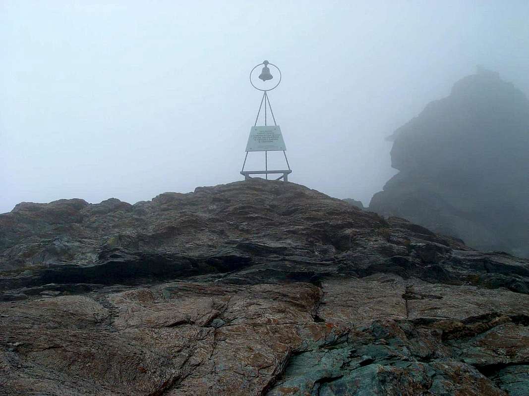
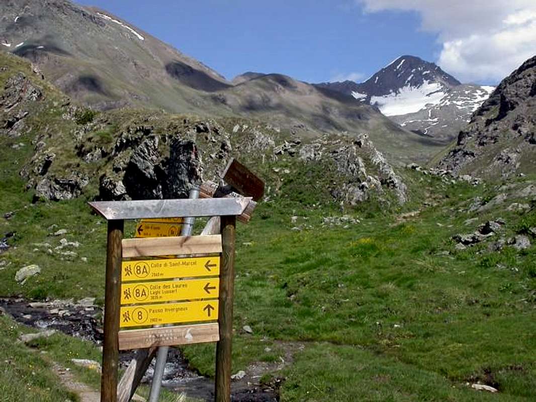
We went to play at the Bell Hill of Arietta to get rid of THE DEVIL
Whenever we leave for the Arietta's Hill the Weather is Nice. But like us, entering the Urtier Walloon, we address the Pass of Arietta, he turns his Back on us and Bad changes. A Curse? Can be. Incidentally everyone knows that the Pass is manned by Mr. DEVIL, which is the Good and Bad Weather. How do you want him too, we know what we're up to. It is an Ancient History, two, perhaps, Years 3000 Ago. Ve tell.
THE DEVIL, angry, burned before the whole Snow, then called back a flock of big Clouds full of Rain, "Now these Bales Break them settle Me!"
, by Antonio.
, by Antonio.
Ogni qual volta partiamo pel Colle dell'Arietta il Tempo é Bello. Ma come noi, entrando nel Vallone dell'Urtier, c'indirizziam al Colle dell'Arietta, lui ci volta le Spalle e cambia in Brutto. Una Maledizione? Può essere. Daltronde tutti san che il Passo é presidiato dal Signor DIAVOLO, che fa il Bello ed il Cattivo Tempo. Come vuol Lui. Anche noi sappiam cosa andiam incontrar. Trattasi d'Historia Antica, di due, forse, 3000 d'Anni Fa. Ve la racconteremo
It seems to me that this here ni begins again to make ROW-DIN! Look at the Rainclouds ... / Me par sto qua anca stavolta ricominci far CASIN! Varda che Nuvolon ...
, by emilius.
 |
, by emilius.
The History of the Arietta's Pass is very old and predates the arrival of the Romans, it had to be frequented by Salassians, People of Celtic origin. Indeed it seems that already inhabitants of Cogne come from the Orco Valley-Soana and only then are transferred in the Valley of Cogne at Crest, coming from what was then not called the Hill of th'Arietta but the Noua or New. Ie new step as an alternative to the Window of Champorcher, however, such as to require the passage before or at the Rosa and of the Balma Hills, at the Rosa of Banchi, and the descent to great Lake Miserin, in Champorcher Valley. The Hill of the Noua allowed a more direct transit, however, complicated by a crossing far from simple, especially in the Piedmont side of a steep ledge, where oblique cut through the rock, diagonally from Northeast to Souhwest. A passage to say the least harsh and not too well known, so much so that even the Cartographers Italian Military Geographic Institute (I.G.M.) represent it in a rather inaccurate. Also, the path to the North to arrive in Aosta Valley was not easy and also very exposed to falling stones from the West Face of the Head of the Nouva (3034m). The use was donated to the transition between the two valleys , and also to transport the precious mineral Mines Cogne (Magnetite or Loadstone of Mines of Larsinaz Veins, Colonna and Costa of the Pino), the same was not brought exclusively in the valley to be worked in Aosta but mainly the last two strands, followed the path through the various hills of the Piedmont. On top of the great rock band above the dirt farm road along the Urtier Valley there is a Cote Piemont that leads to Alp Tsavanis, a name that clearly indicate a way forward in order to get from the Colonna's Mine and passing through the Taveron(n)a, Seutse or Suches, Gueula Dessus and Desot Pastures, the walloons of the aforementioned hills allege in this region. Remain the clear traces of Drive-Ways built for this purpose, not only to Colle dell'Arietta but also to that of the Acque Rosse, under the Tower of Lavina. These steps, along with those of the Hills, from the Northeast to the Southwest, of the Miserino, Scaletta's Pass and the Bocchetta of Rancio favored trade , business, culture and good marriages last.
The LORD DEVIL is right behind it. I do not know if you can see IT
, by emilius.
 |
, by emilius.
La Storia del Colle dell'Arietta é molto antica e precede l'arrivo dei Romani; esso doveva essere frequentato già dai Salassi, popolo di origine Celtica. Anzi pare che gi abitanti di Cogne provengano dalla Valle dell'Orco-Soana e solo successivamente si sian trasferiti nella Valle di Cogne in località Crest, arrivando da quello che allora si chiamava non Colle di Arietta bensì della Noua o Nouva. Cioé nuovo passaggio in alternativa a quello della Finestra di Champorcher, tale però da richiedere lo scavalcamento antecedente tramite i Colli o della Rosa o della Balma, presso la Rosa dei Banchi, e la discesa al grande Lago Miserin, in Valle di Champorcher. Il Colle della Noua permetteva transito maggiormente diretto, complicato però da un'attraversata per nulla semplice, soprattutto nel versante Piemontese, ove una ripida cengia obliqua tagliava diagonalmente da Nordest a Sudovest la parete rocciosa. Un passaggio a dir poco impervio e neppur troppo ben conosciuto, tanto ne é che anche i Cartografi dell'Istituto Geografico Militare Italiano (I.G.M.) lo rappresentano in modo alquanto impreciso. Inoltre anche il percorso a Settentrione per giungere in Valle di Aosta non era semplice ed inoltre molto esposto alla caduta di Pietre dal Versante Ovest della Testa della Nouva (3034 m). L'utilizzo era devoluto al passaggio tra le due vallate ed inoltre al trasporto del pregiato minerale delle Miniere di Cogne (Magnetite dei Filoni di Larsinaz, Colonna e Costa del Pino); lo stesso non veniva portato esclusivamente a valle per esser lavorato ad Aosta ma, principalmente i due ultimi filoni, seguiva la via del Piemonte tramite i vari colli. Al di sopra della grande fascia rocciosa soprastante la strada poderale del Vallone dell'Urtier esiste una Cote Piemont che raggiunge l'Alpe Tsavanis, toponimo tale da indicare chiaramente una via da seguire onde raggiungere, partendo da Colonna e transitando per le Alpi Taverona, Seutse, Gueula Dessus e Desot, i valloni dei predetti colli che adducono a questa regione. Rimangono le nette tracce di Carraie costruite a tal scopo, non solo al Colle di Arietta ma anche a quello di Acque Rosse, sotto alla Torre di Lavina. Questi passaggi, insieme a quelli dei Colli, da Nordest a Sudovest, di Miserino, Passo della Scaletta e la Bocchetta del Rancio favorivano gli scambi, commerciali, culturali e buon da ultimo i matrimoni.
More and more emilius plays the "DIAVOLACCIO" is making me ANGRY TIME increasingly BAD. But emilius "not does & not loosen and never gives",
by Osw.
 |
by Osw.
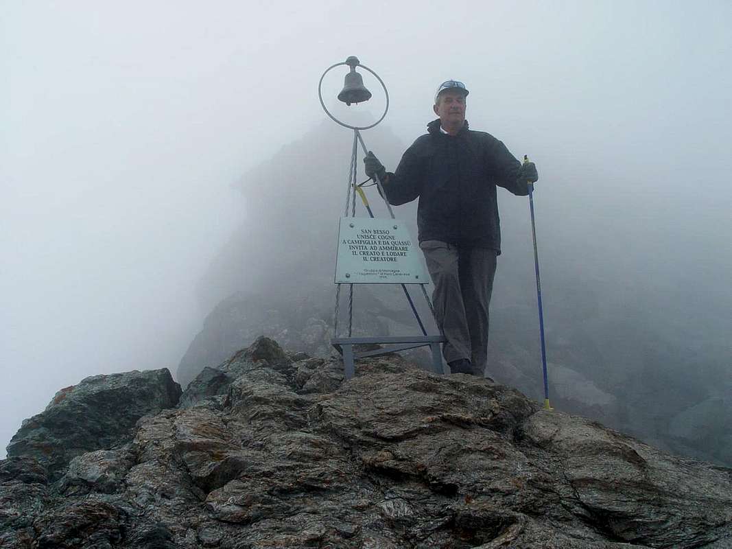
We, however, that we are the "Stubborn" , we continue to move upwards. "Ugly Devil Horned We 'll show you who we are!". And began the climb to the Col of Arietta. One more time. " Ah, yes, you are right the "Obstinates", you two. Who you think you are to come to challenge Me, Mr. Devil. Already I had to retire here, because there where I lived before, to Truc de Lo Dzjablo or Grange the Diabùl, they built the Sanctuary of San Besso and I have dislodged. And now you come too to annoy with your "cameretta". Luckily, you do not have even pulled behind the other. That'Antonio is that you "shoot" photos like a machine gun. So much of My Privacy. But as I settled Salassians and Romans, as well settle too. Only Mother Church has managed to limit my range. But, you know , those are Priests and they have wings behind the back Vatican ... ". He said that and so he did: first , by boiling Anger, set fire to the Head of Arietta and Point of Nouva, melting all the snow that oozed from Fear, then drew a flock of Mass of Clouds pregnant with Rain, which became white as Seagulls in short blacks as ugly Ravens. It turned out The Bedlam. emilius and I slid from all sides, bluish on that rock, where probably "our" had poured liquid soap. In fact exhilarating as the tiny soap. The Little Bell just over there seemed unattainable. We reached it, too. After an attempt to emilius, to which I had witnessed in astonishment, that he had not been successful despite a prolonged sound, I departed the office. Struggling in the manner of "Fantozzi" , joined her. The ringing to the point that I would have to feel down in Cogne and throughout the Valsoana. A loud laughter echoed in the air. Immediately after a shower of rain there very violent beatings. Then a great voice thundered: " Look at this idiot who pretends, with that face in the form of dopey, to be too surprised. Ah , I'll give you the Bell, but in the head !". A gust of wind and rain hit us head-on. Slowly descended on the smooth rock, smooth and wet, trying not to beat your ass. We took shelter under the usual rock, a little shaped canopy. The Rock of Despair. Anoraks and slipped silently ate our sandwich. By God we had defied The DIAVUL, that is not something of little importance ...
Noi, che però siam degli "Ostinati", continuiamo ad andar in sù. "Brutto Diavolo Cornuto ti facciam veder Noi chi siam!". Ed iniziò la salita verso il Colle di Arietta. N'altra volta ancora. "Ah! si, siete proprio dei "Testardi", voi due. Ma chi credete d'esser da venir sfidar Me, il Signor DIAVOLO. Già mi son dovuto ritirar quassù, perché laggiù dove abitavo prima, al Truc de Lo Dzjablo o alla Grangia del Diabùl, han costruì il Santuario del San Besso e m'han sloggià. E adesso venite anca voi a dar rottura con la vostra macchinetta fotografica. E men mal che non avete tirato dietro anche quell'altri. Si quel Antonio che "spara" foto come 'na mitragliatrice. Alla faccia della Mia Privacy. Ma come ho sistemato Salassi e Romani, così adesso sistemo anche voi. Solo Madre Chiesa l'é riuscita a limitar mio raggio d'azion. Ma, si sa, quelli sono Preive ed han dietro ala schiena il Vatican ... ". Così disse e fece: prima, bollente dalla Rabbia, diede fuoco alla Testa di Arietta ed alla Punta della Nouva, sciogliendo tutte le nevi che trasudavano dalla Fifa, poi richiamò 'no Stormo di Nuvolon gravidi di Pioggia, che da bianchi come Gabbiani si fecer in breve ner come Corvacci. Ven fuor el Finimondo. emilius ed io scivolavamo da tutte le parti, su quella roccia bluastra, dove probabilmente "il nostro" aveva versato sapone liquido. Infatti slittavamo come saponette. La Campana appen lì sopra sembrava irraggiungibile. La raggiungemmo, ugualmente. Dopo un tentativo dell'emilius, al quale avevo assistito attonito co 'na faccia da cretino, che non aveva dato buoni frutti nonostante un suono prolungato, partii io alla carica. Arrancando, alla maniera di "Fantozzi", la raggiunsi. La feci squillar a tal punto ch'avrebbero dovuto sentir giù fin a Cogne e tutta la Valsoana. 'Na risata terrificante echeggiò nell'aere. Subito dopo un scroscio di pioggia viùlent ci percosse. Poi 'na gran Voce tuonò: "Ma guarda stò stupid che fa finta, con quella faccia da scimunì, d'esser anche sorpreso. Ah, te la dò io la Campana, ma in testa!". 'Na raffica di vento con pioggia ci frustò frontalmente. Lentamente calai su quella roccia liscia, levigata e bagnata, cercando di non batter culo. Ci rifugiammo sotto la solita roccia, un pò a forma di tettoia. La Roccia della Disperasion. Infilammo le giacche a vento e muti mangiammo il nostro panino. Perdio avevam sfidà El DIAVUL, che mica l'é cosa da rider ...
Better and better we play this "SATANASSO" gets bored. Osva looks stunned: "I'm going to play me! Worse than to go at Night!! Take refuge!!!
by emilius & Osw.
 |  |  |  |
by emilius & Osw.
The Story of San Besso, which is in any case always connected to the Evil One, is lost in time. Holy Shepherd of the Theban Legion or killed by other shepherds to envy? Legend tells that , in any case, he was thrown from the Monte Fauterio or Fautenio and even also called Fantono, from the Alp Fanton just below, at the foot of which was built alongside the Sanctuary with a small votive chapel. Previous Place of Worship Christian Era was recognized by the Pagans, probably the Populations Celtic - Salassian that passed between the Canavese and the Cogne Valley for business affairs, but since then, probably, also for the transport of Ironore, the religion then turned to Other Gods, before the Middle Ages arose Worship and the relative Fear of the Devil. It appears, that the place had a name relating to the same. It could be the Truc of the Devil? Where the Truc is to mean a rock by the passage difficult. Incidentally the passage of the hill instilled fears always. Understandable. In the Seventeenth Century was built the shrine dedicated it to San Besso, was completed in 1669 and major renovations took place in 1857 and 1985. Traditional destination for meetings between the populations of the two valleys on August 10th, even today , make a Procession, with the "Cogneins" required to pass the Arietta's Hill to be able to go to the San Besso Sanctuary. Almost a recognition due to their distant origins, so that in time past were worn traditional costumes. But this was also true for the Piedmontese of each valley, as if to confirm their Identity. Tradition has it that the statue completes a lap around the big boulder of Martyrdom and, in time past, there were few arguments which broke out among the inhabitants of Campiglia Soana and those of Cogne in order to obtain the Honor of Transportation, with lots of tender ritual. Other times, today, maybe, it could happen the other way around! Other devotees come for the occasion, also from Champorcher Valley, through the primeval Balma's Hill, a unit of devotees intent, which gets connected to another Legend as to highlight a link between the Saints Porzio or Porciero ( whence Champorcher ) and Besso, it would seem, comrades escape from the Theban Legion and both, then, Martyrs. Indeed it is said that belonged to that group of Milites 6600, led by Saint Maurice, murdered in 286 AD by order of Emperor Maximian for refusing to worship the Pagan Gods, the massacre happened at Agaunum, currently in Bourg Saint Maurice Swiss Canton of Valais. The survivors, including the Legionary Besso, strove for the Evangelization in the Mountains, with the Emperor minions always at their heels, determined to make a clean sweep. Other versions speak instead of a plot of mountaineers who would then handed over to the Romans and this hypothesis is true for the one as the other valley, so that may have been killed by them in Cogne, where he had fled. Finally, a further history, its research scholar Anthropologist Robert Hertz in 1912, according to which a story passed down from generation to generation in the Cogne Valley is only as a good shepherd with his flock prosperous, and his devotion and his "well-being" would have provoked the envy and rage of other mountaineers atheists, then the architects of Martyrdom.
But who was really San Besso? You want to remember as the Great Healer, Protector of Soldiers from the War and finally Holy Man.
But who was really San Besso? You want to remember as the Great Healer, Protector of Soldiers from the War and finally Holy Man.
La Storia di San Besso, che va in ogni caso sempre collegata al Maligno, si perde nel Tempo. Santo della Legione Tebea o Pastore ucciso da altri pecorai per invidia? La Leggenda tramanda che, in ogni caso, fu gettato dalla Monte Fauterio o Fautenio oppure ed anche Fantono dall'Alpe Fanton appena sotto, ai piedi del quale é stato costruito il Santuario con al fianco una cappellina votiva. Luogo di Culto precedente all'Era Cristiana era riconosciuto dai Pagani, probabilmente le Popolazioni Celtico-Salasse che transitavano tral Canavese e la Valle di Cogne per affari commerciali, ma già sin d'allora, probabilmente, anche per il trasporto del Minerale di Ferro; la religione di allora si rivolgeva ad Altri Dei, prima che dal Medio Evo sorgesse il Culto e la relativa Paura del Diavolo. Par, infatti, che il luogo avesse un toponimo riguardante il medesimo. Potrebbe esser il Truc del Diavolo? Dove quel Truc sta a significar una roccia dal passaggio difficile. Daltronde il passaggio del colle incuteva paure da sempre. Comprensibili. Nel XVII° Secolo venne edificato il Santuario dedicandolo a San Besso; fu completato nel 1669 ed importanti restauri avvennero nel 1857 e nel 1985. Tradizionale meta di incontro tra le popolazioni delle due vallate che il 10 di Agosto, ancor oggigiorno, effettuano una Processione, con i "Cognensi" obbligati a passar il Colle d'Arietta per potersi recare al Santuariodel Santo Besso. Quasi un riconoscimento dovuto alle loro lontane origini, tanto che nel tempo passato venivan indossati i costumi tradizionali. Ma questo valeva anche per i Piemontesi d'ogni vallata, palesemente a voler confermar la loro Identità. La Tradizione vuol che la statua compia un giro attorno al roccione del Martirio e, nel tempo passato, non poche eran le liti che scoppiavano tra gli abitanti di Campiglia Soana e quelli di Cogne onde ottenere l'Onore del Trasporto, con tanto di bando rituale. Altri tempi, oggi, forse, potrebbe succedere il contrario! Altri devoti giungono, per l'occasione, anche dalla Valle di Champorcher, attravers'al primigenio Colle della Balma; un'unità di devoti intenti, che si fà collegare ad altra Leggenda tale da evidenziare un legame tra i Santi Porzio o Porciero (donde Champorcher) e Besso, sembrerebbe, compagni di fuga dalla Legione Tebea ed entrambi, poi, Martiri. Anzi si racconta che appartenesse a quella schiera di 6600 Milites, con a capo San Maurizio, trucidata nel 286 dopo Cristo con ordine dell'Imperatore Massimiano per non aver voluto adorare gli Dei Pagani; l'eccidio avvenne ad Agaunum, attualmente Bourg Saint Maurice nel Canton Vallese Svizzero. I superstiti, tra i quali il Legionario Besso, si adoperarono per l'Evangelizzazione nelle Montagne, con alle calcagne sempre gli sgherri dell'Imperatore, decisi ad effettuar tabula rasa. Altre versioni parlano invece d'un complotto di montanari che lo avrebbero poi consegnato ai Romani e questa ipotesi vale per l'una quanto l'altra vallata, tanto che potrebbe essere stato ucciso dagli stessi a Cogne, ove s'era rifugiato. Infine, un'ulteriore storia, propria della ricerca dello studioso Antropologo Robert Hertz del 1912, secondo la quale un racconto tramandato di generazione in generazione nella Valle di Cogne lo rappresenta solo come un buon pastore con il suo prospero gregge; la sua Devozione ed il suo "benessere" avrebbero scatenato l'invidia e la furia di altri montanari atei, poi artefici del Martirio.
Ma chi era veramente San Besso? Lo si vuole ricordare come Grande Taumaturgo, Protettore di Soldati dalla Guerra ed infine Santo.
It was certainly not easy for the poor devils bring before the cart, then the mule and finally walk the ore from Cogne to the Plain of Ivrea. It was really a DEVIL's ROAD!
, by emilius.
Ma chi era veramente San Besso? Lo si vuole ricordare come Grande Taumaturgo, Protettore di Soldati dalla Guerra ed infine Santo.
 |  |  |  |
, by emilius.
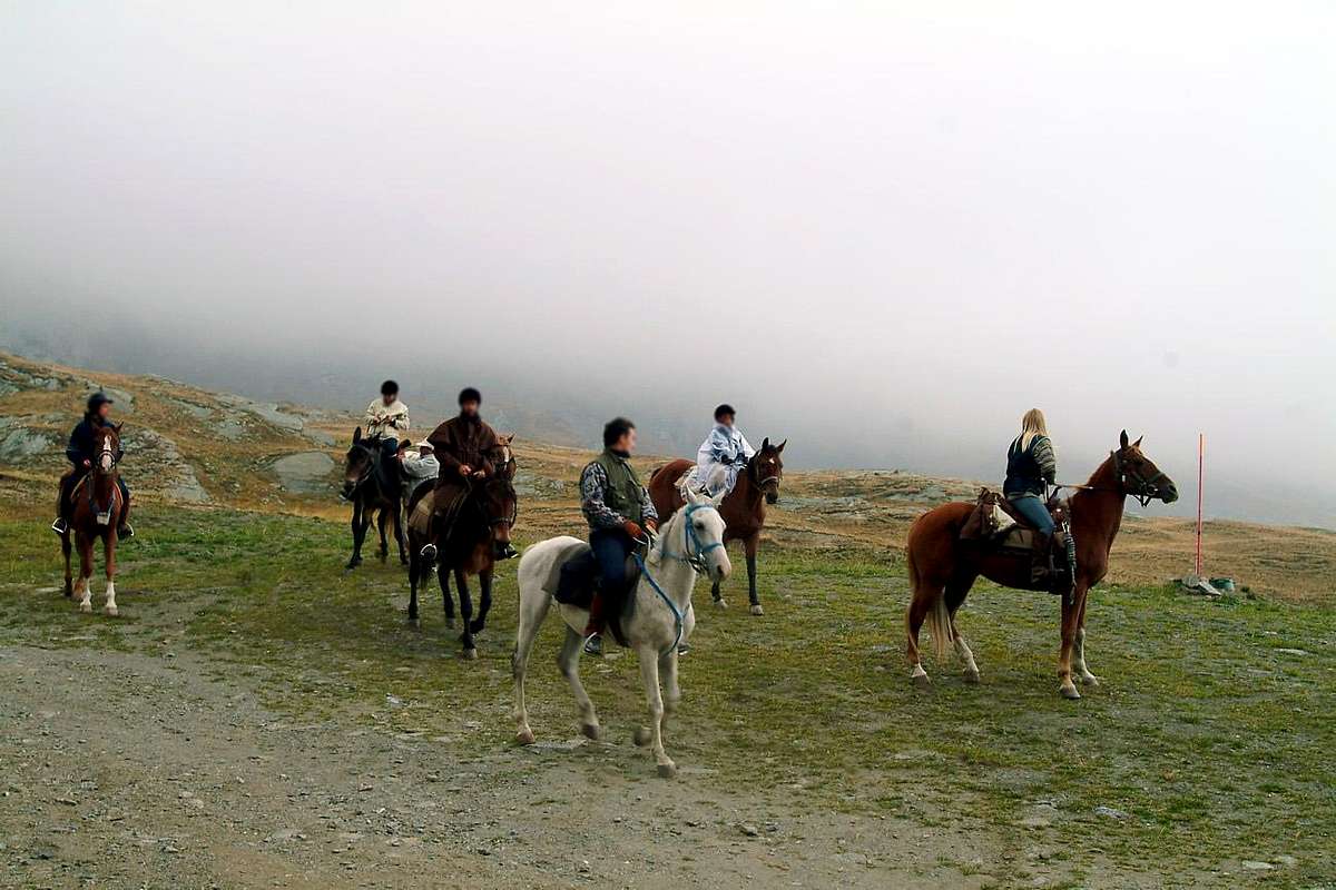
After this break-culinary meditative, recharge the batteries, despite the fact that Mr. Devil does not put an end to the bad weather, we decided one more thing: "If it will not go ringing the Bell of the Holy Ghost, the wander behind and, after having climbed the Head of th'Arietta (2988m) along the Northeast Ridge, we attack the downhill behind, forcing him to escape". Redone the "baggage" we begin to climb in a dense Fog, almost like those of Dante, that smells like Hell. Truly a Time of the Devil! After reaching the Summit, we descend to start the WAR with the Devil. Painfully descend on those rocks. Easy but wet and slippery. Sometimes we have to support over to the shoulder, not to lose the balance. "Ah, good to have two sticks, first to help the down and two to four whacks him in the head! Other than giving the bell at the head of us ...". Never mind, it will face in surprise and the lash down the ravine of th'Arietta in Valsoana, as they did for San Besso. "But when we get to the rock above the bell no longer find even his Shadow, Shadow of the Devil. Yet the view we had, indeed photographed. We are Witnesses also You, that in the "Painting" (literal translation from Italian) here above you saw hip Vol Come on we are serious people, not of Bale counter!". No, there is not a Devil Nothing ... Returning downstream we encounter a platoon of riders. Us assume that soldiers giving them the mission to Attack the Devil. We want to just see if he can escape even this attempt this Hell of a Devil ...
Dopo sta pausa culinaria-meditativa, ricaricate le batterie, nonostante ch'il Signor Diavolo non faccia cessar Maltempo, decidiamo 'n'altra cosa: "Se non sen va suonando la Campana del Santo, lo aggiriam alle spalle e, dopo aver salito la Testa dell'Arietta (2988 m) lungo la Cresta Nordest, l'aggrediamo in discesa alle spalle, costringendolo alla Fuga". Rifatti i "bagagli" iniziam a salir in fitta Nebbia, quasi come quelle Dantesche, che puzzan d'Inferno. Veramente un Tempo del Diavolo! Raggiunta la Vetta, scendiam per dar inizio alla GUERRA col Diavol. Penosamente caliam su quelle rocce. Facili ma bagnate e scivolose. A volte dobbiam poggiar un di spalla all'altro, per non perder Equilibrio. "Ah, aver due buon baston, per prima cosa aiutar discesa e due per dargli quattro randellà in testa! Altro che dar la Campana in testa a noi ... Niente, l'affronterem sorpresa e lo sbattiam giù dalla burra dell'Arietta in Valsoana, com'han fatto col San Besso". Ma quando arriviam al roccion sopra la Campanella non troviam più neppur l'Ombra, l'Ombra del Diavolo. "Eppur l'avevam vista, anzi fotografata! Ne siete Testimoni anche Voi, che nella "Pittura" (traduzione alla lettera dall'English) qua sopra l'avete vista anca Voi. Suvvia siam gente seria, mica dei Contaballe!". Niente, non c'é un Diavol di Gniente ... Tornando a valle contriam un ploton de cavallerissi. Lo assoldiam dand lor Mission d'attaccar el Diavol. Ah, vogliam propri veder se riesce scansar anche sto tentativo sto Diavol d'un Diavol ...
Mission on horseback against the DEVIL. Ready GO!
, by emilius.
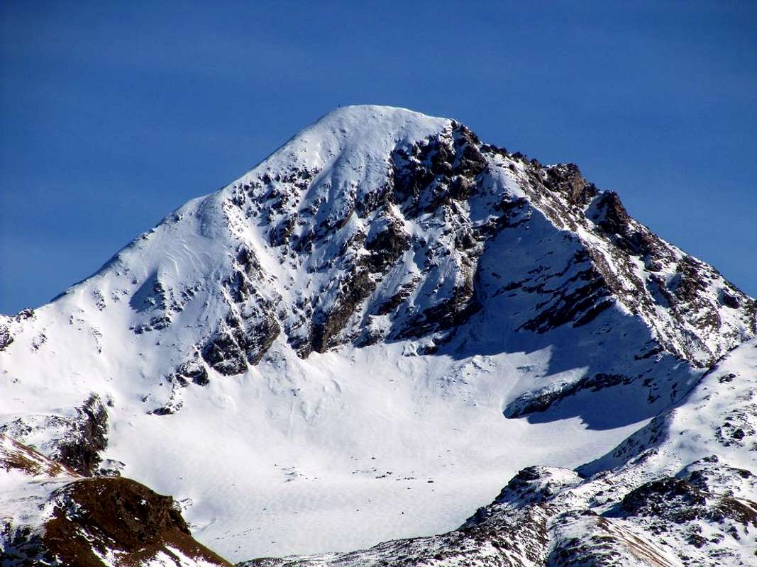
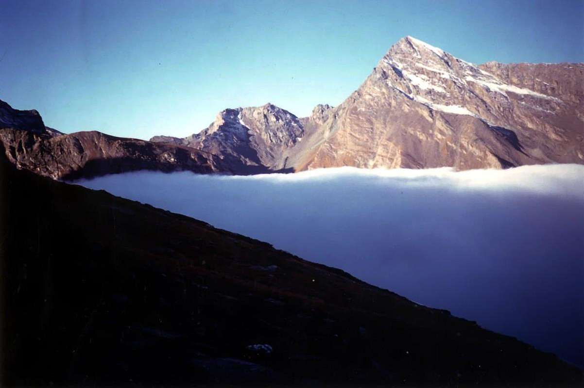
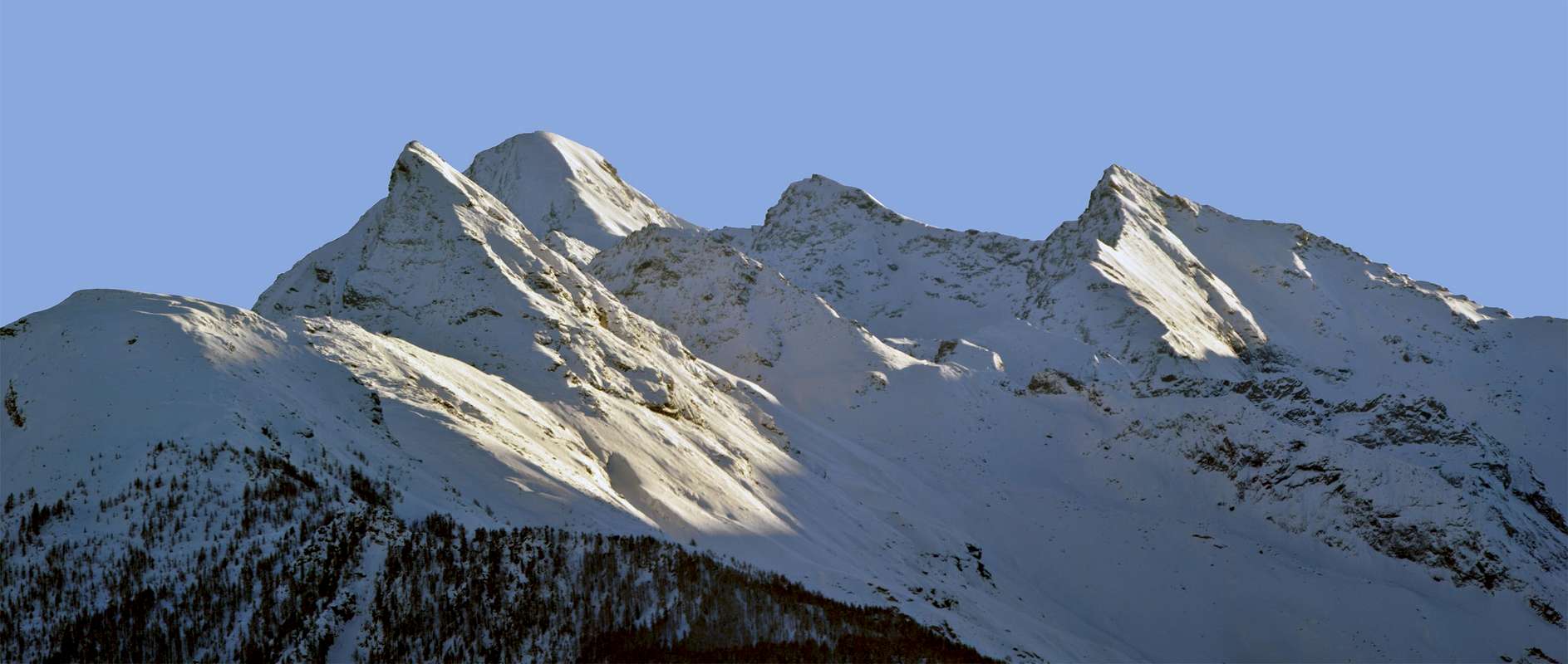
"I am The Tersiva. There is no more to say!The August 23, 1842, the Curé of Cogne & a Student made me become the QUEEN of GRAIANS Southeast",
by Corvus
 |
, by emilius.
The Madame Tersiva rides three Tigers
by Corvus
 |
Everyone knew he was a Tersiva The Lioness, ready to bite chiunqe you did find close; few know that she dominates three Tigers. They are the valleys that originate vital waters. Fénis-Clavalité, Cogne and Champorcher "host" Madame. She is not nobody's is, simply, The Tersiva. It rises and dominates for over on the World and not interested in anything or anyone. "I am the Tersiva, this is sufficient. Of the men and what they think I do not care anything! My Throne is in these mountains, which have already been marginalized by man. But I live well too and I do not want to have other disorders. I am the Lady of the valleys, and when winter comes, I rise like a goddess, like Ama Dablam. They are white and shiny but, above all, unreachable.". So for Millennia Madame dominated his world, his Piccolo Mondo Antico. The three Tigers obeyed without resistance. It was the Life Cycle. Everything flowed naturally and no one had anything to say. But there came a man ...
"Signs here, signals there. Just now there are more panneaux that Mushrooms! ..." / "Cartelli di qua, cartelloni di là. Basta, ormai ci son più panneaux che Funghi! ... ",
by livioz
This brought signs and signals everywhere: up, down, which alp, lake or hill, to the right and to the left, how many hours walk and minutes, with circles, and yellow triangles rectangles, with what difficulties and so forth. Never a word about Tersiva, never a mention of the name of the streams. "But what are we, League B or are we the backbone and the Life for these Valleys?". So he questioned Madame and her Vassals, three Tigers that she rode through the Walloons of Urtier of Grauson-Doreire and, in the North, to the Dora Baltea River, Fénis-Clavalité-High Comba Tersiva. Ah, had "ruined" with this last hint. Little stuff. He felt terribly offended. And the others with her.
Tersiva said: "But we in the great Flood of 2000 we did not hurt anyone. Oblige to ostracism because these there?" The answer was easy: they know not what they say and, more importantly, what they do. These live in the Fashion and, you know, fashion is the time that it finds. We must not we change in mood much. We are what we are. They, like all fashions, they last a while and are destined to disappear without even realizing what is happening. So Tersiva continued to live peaceful and quiet and also its three main torrents. The problems were something that belonged to others. Not to Madame La Tersiva and his Emissaries. Three Tigers ready to roar ...
"and when Winter comes, I rise like a goddess, like Ama Dablam. They are white and shiny ..." / "e, quando arriva l'Inverno, m'innalzo siccome Dea, come l'Ama Dablam. Son bianca e lucente ... ",
by Antonio
by livioz
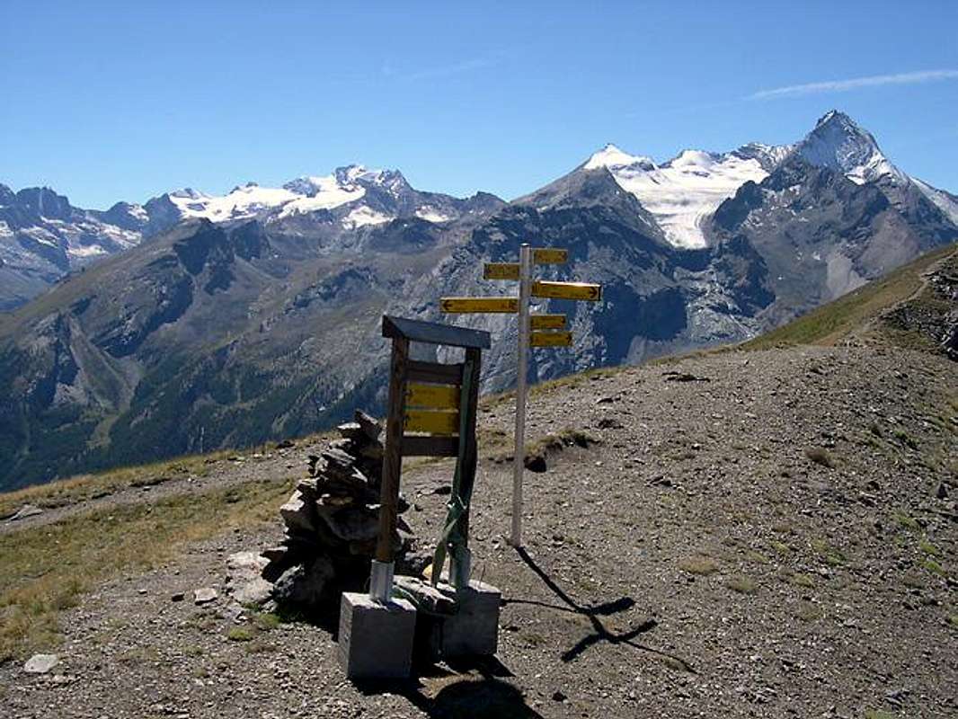 |
This brought signs and signals everywhere: up, down, which alp, lake or hill, to the right and to the left, how many hours walk and minutes, with circles, and yellow triangles rectangles, with what difficulties and so forth. Never a word about Tersiva, never a mention of the name of the streams. "But what are we, League B or are we the backbone and the Life for these Valleys?". So he questioned Madame and her Vassals, three Tigers that she rode through the Walloons of Urtier of Grauson-Doreire and, in the North, to the Dora Baltea River, Fénis-Clavalité-High Comba Tersiva. Ah, had "ruined" with this last hint. Little stuff. He felt terribly offended. And the others with her.
Tersiva said: "But we in the great Flood of 2000 we did not hurt anyone. Oblige to ostracism because these there?" The answer was easy: they know not what they say and, more importantly, what they do. These live in the Fashion and, you know, fashion is the time that it finds. We must not we change in mood much. We are what we are. They, like all fashions, they last a while and are destined to disappear without even realizing what is happening. So Tersiva continued to live peaceful and quiet and also its three main torrents. The problems were something that belonged to others. Not to Madame La Tersiva and his Emissaries. Three Tigers ready to roar ...
by Antonio
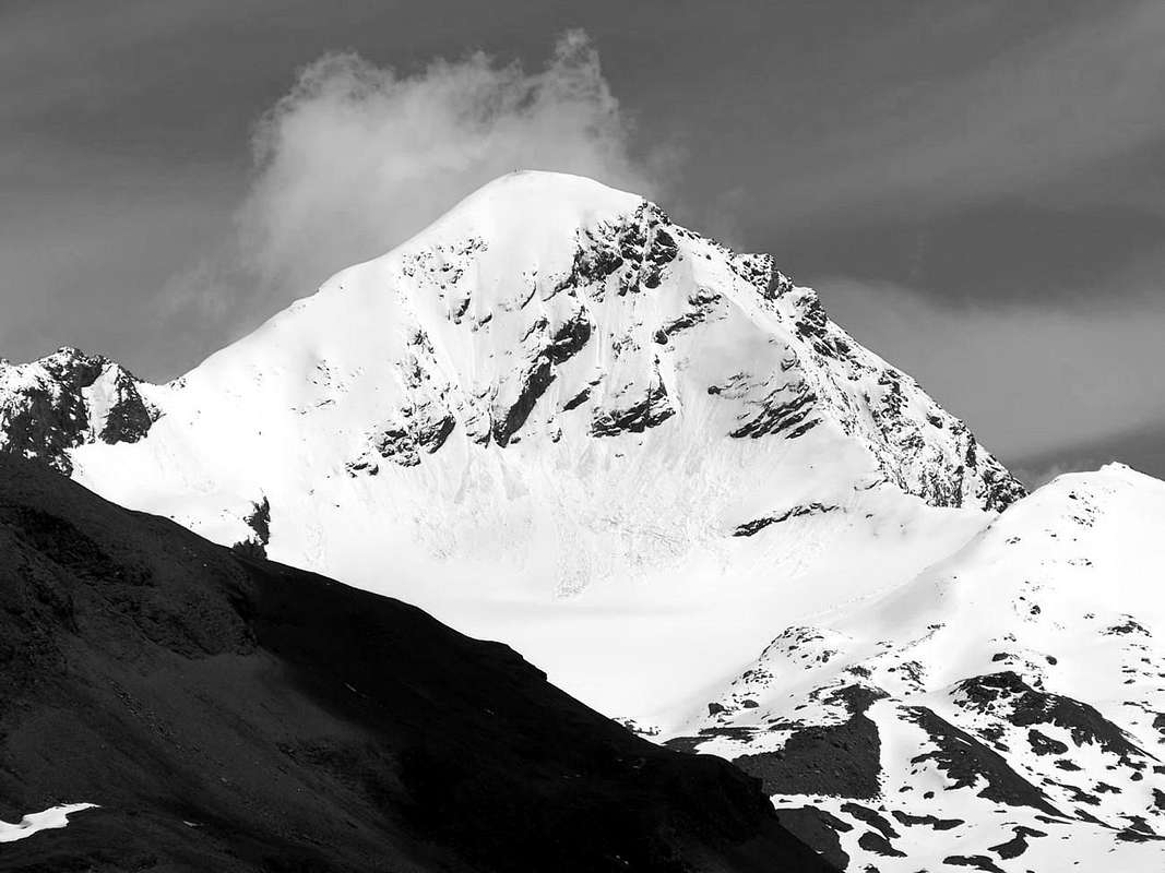 |
Tutti sapevan che La Tersiva era 'na Leonessa, pronta a morder chiunqe si facesse trovar vicino; pochi sanno che lei domina tre Tigri. Sono le valli che originano acque vitali. Fénis-Clavalité, Cogne e Champorcher "ospitano" Madame. Lei non é di nessuno: é, semplicemente: La Tersiva. S'innalza per oltre 3500 metri sul Mondo e non le interessa di Niente e di Nessuno. "Sono la Tersiva, questo é sufficiente. Degli uomini e di quello che pensano non mi interessa proprio nulla! Il mio Trono é tra queste montagne, che già sono state emarginate dall'uomo. Ma io vivo bene ugualmente e non voglio avere altri disturbi. Domino le valli e, quando arriva l'Inverno, mi innalzo come una Dea, come l'Ama Dablam. Sono bianca e lucente ma, soprattutto, irrangiungibile.".
Così per Millenni Madame dominava il suo Mondo, il suo Piccolo Mondo Antico. Le tre Tigri obbedivano senza alcuna Resistenza. Era il Ciclo della Vita. Tutto scorreva in modo naturale e nessuno aveva nulla da dire. Ma arrivò l'uomo ...
"'It is no quoted it anymore. Had fallen into OBLIVION and the signs indicating only the hills ... " / "Ormai non la citava più nessuno. Era scivolata nell'OBLIO ed i panneaux eran tutti pei Colli ... ",
by Antonio
Così per Millenni Madame dominava il suo Mondo, il suo Piccolo Mondo Antico. Le tre Tigri obbedivano senza alcuna Resistenza. Era il Ciclo della Vita. Tutto scorreva in modo naturale e nessuno aveva nulla da dire. Ma arrivò l'uomo ...
by Antonio
 |
Questo metteva cartelli e segnalazioni ovunque: In sù, in giù, a quale alpe, lago o colle, a destra ed a sinistra, con quante ore di percorrenza e minuti, con circoli, rettangoli e triangoli gialli, con quali difficoltà eccetera. Mai una sola parola sulla Tersiva, mai un accenno al nome dei torrenti. "Ma cosa siam noi, di Serie B oppur siam noi l'asse portante e la Vita per questi Valli?". Così s'interrogavano Madame ed i suoi Vassalli, tre Tigri che lei cavalcava attraverso i Valloni dell'Urtier, del Grauson-Doreire ed, a Settentrione verso la Dora Baltea, di Fénis-Clavalité-Alta Comba Tersiva. Ah, s'eran "rovinati" con questo ultimo minimo accenno. Poca roba. Si sentiva terribilmente offesa.
"He felt terribly offended and looking at the remains of its glaciers regretted the Good Old Days" ... / Si sentiva terribilmente offesa e guardando i resti dei suoi ghiacciai rimpiangeva i Bei Tempi Passati" ... ,
by Antonio
E gli altri con lei. Disse la Tersiva: "Ma noi nella grande Alluvione del 2000 non abbiam fatto del Male a Nessuno. Perché questi ci costrigono all'ostracismo?" Facile fu la risposta: questi non sanno quello che dicono e, soprattutto, quello che fan Questi vivono alla Moda e, si sa, la moda trov'al tempo che trova. Non dobbiamo alterarci più di tanto. Noi siamo quello che siam. Loro, come tutte le mode, duran 'n attimo e sono destinati a sparir senza nemmeno accorgersi di quanto sta succedendo. Così la Tersiva continuò a vivere serena e tranquilla ed anche i suoi tre principali torrenti. I problemi eran cosa che apparteneva agli altri. Non a Madame La Tersiva ed ai suoi Emissari. Tre Tigri pronte a ruggir ...
"Three Tigers were in the Soul of his Torrents and Tersiva began in Silence. The Disappointment drained their Veins ..." / "Tre Tigri ch'eran nell'Anima dei suoi Torrents e la Tersiva tacquero in Silenzio. La Delusion prosciugò lor Vene ... ",
by emilius
by Antonio
 |
E gli altri con lei. Disse la Tersiva: "Ma noi nella grande Alluvione del 2000 non abbiam fatto del Male a Nessuno. Perché questi ci costrigono all'ostracismo?" Facile fu la risposta: questi non sanno quello che dicono e, soprattutto, quello che fan Questi vivono alla Moda e, si sa, la moda trov'al tempo che trova. Non dobbiamo alterarci più di tanto. Noi siamo quello che siam. Loro, come tutte le mode, duran 'n attimo e sono destinati a sparir senza nemmeno accorgersi di quanto sta succedendo. Così la Tersiva continuò a vivere serena e tranquilla ed anche i suoi tre principali torrenti. I problemi eran cosa che apparteneva agli altri. Non a Madame La Tersiva ed ai suoi Emissari. Tre Tigri pronte a ruggir ...
by emilius
 |
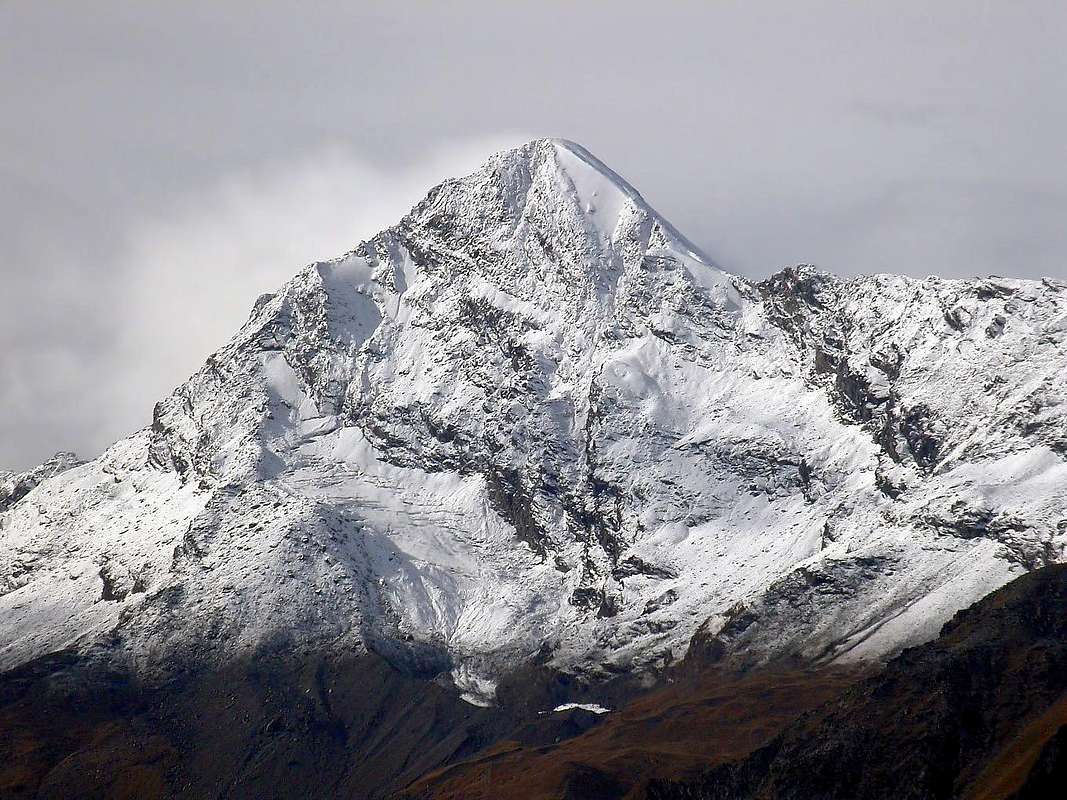
But this fact to be Falling by the wayside gave her a significant Nuisance. Touched his Pride Female. Sea of Clouds at first looked in the mirror between them, "My God how I became old and ugly, they are completely dry and wrinkled. Maybe they have a point to forget". He called to review the clouds and gave them orders to cover it with a nice white coat, like when he was young. The clouds promptly obeyed, and with a big snowfall, the engulfed in a thick white blanket. It seemed an Ermine! He looked in the mirror again and tide, happy, he found himself again Very Beautiful.
She also became more generous, sending torrents and tiny waterfalls to its three main streams. Even they felt transformed and regenerated. They ran toward the walloons as Three Tigers, roaring at every bend ...
"MIRROR, oh Mirror of my CRAVINGS, tell me if I'm back to being the fairest of the KINGDOM ..." / "SPECCHIO, oh specchio delle mie BRAME dimmi se son tornata ad esser la più Bella del REAME ... ",
by Osw
She also became more generous, sending torrents and tiny waterfalls to its three main streams. Even they felt transformed and regenerated. They ran toward the walloons as Three Tigers, roaring at every bend ...
by Osw
 |
Però sto fatto d'esser caduta nel Dimenticatoio le dava notevole Fastidio. Toccava il suo Orgoglio di Femmina. Al primo Mar di Nuvole si guardò allo specchio tra le stesse: "Mio Dio come son diventata vecchia e brutta, son completamente asciugata e pien di rughe. Forse non hanno tutti i torti a dimenticarmi!". Chiamò a rassegna le Nubi e dette lor ordine di ricoprirla d'un bel manto bianco, come quand'era giovine. Le nuvole prontamente obbedirono e, con una grande nevicata, la sommersero d'una spessa coltre bianca. Sembrava un Ermellino! Si guardò di nuovo nello specchio della marea e, felice, si ritrovò nuovamente Bellissima.
Diventò anche più generosa, inviando torrenti e cascatelle d'acqua verso i suoi tre torrenti principali. Anche lor si sentiron trasformati e rigenerati. Si rimiser a correr verso valloni come Tre Tigri, ruggendo ad ogni ansa ...
"Clouds They gave her a new LOOK making her return to Young & Beautiful ..." / "Le Nuvole Le diedero un nuovo LOOK facendola tornar Giovin & Bella ... ",
by Antonio
"I am the Pear that protects the Tersiva cold Winds from the North. I am Launcelot the Brave" / "Son la Spada che protegge la Tersiva dai freddi Venti del Nord. Il Prode Lancillotto",
by emilius
Diventò anche più generosa, inviando torrenti e cascatelle d'acqua verso i suoi tre torrenti principali. Anche lor si sentiron trasformati e rigenerati. Si rimiser a correr verso valloni come Tre Tigri, ruggendo ad ogni ansa ...
by Antonio
 |
There was Launcelot? It looks like the Point of Tessonet
by emilius
 |
The Punta del Tessonet takes its name from the adjacent Glacier Tessonet, once also called Doreire or Dorère that the strap on the south slope going up to the pyramid Tersiva. A form of small triangular arrow lies slightly to the East, is a node topographic very important, from the top down two significant ramifications in the structure of this group of mountains. The first is North facing and, in the shape of a Y which she forms the basis, and even the watershed between the Walloons of Saint Marcel (West) and on the opposite side of Fénis-Clavalité-High Comba Tersiva, the two vertices are made by Montroux in North-northwest and from the Mont Saint Julien North-northeast. The node partition of these two branches is located in Mount Courquet (2529m), large grassy-rocky dome, which looks like a large balcony on the Central Valley River Dora Baltea. Its other branch is even more extensive and important: in this case the Point of Tessonet forms the base of a large tree, the foliage of which extends from the North to the Northwest to finally bend to the South and Southwest with a span of about 270° and over, if we consider the "beam" after which horizontal, 360° complete. In fact, various nodes topographic unfold, with the trend above, by sending back a radial pattern in order to reach the Central Valley of the Dora, the City of Aosta, the Municipality of Aymavilles, at the Valley of Cogne, and Cogne it and, going back to the North, its Walloon of Grauson. We will have a first axis, which would constitute the "trunk" of this great plant, formed by the Collar Tessonet, Point Gianni Vert, two Tops of Laval, Saint Marcel or Corona's Hill, Mount Vallonet and glues and finally Leppe's Point. From here the tree "open" and extends its branches, always with the guidance above, give rise to:
a)- branching Range Roèses, ending with Becca and the Tower of Salé, above the Municipality of Grand Brissogne .
b)- branching from the Group of Emilius, made up of many joints, which ends in his right arm to the North-northwest, or at Père Laurent Mount above the little towns of Grand Brissogne and Pollein and in the left, the more "incomplete", the Becca of Nona, above the Municipalities of Pollein and Charvensod, on the Southern outskirts of Aosta City.
c)- branching from Emilius first to the South including Point Rossa, Mount Valaisan, Peak Garin and his long South--southwest Buttress that goes down to the Point Arpisson, above the Tourist Village of Gimillan.
d)- internal branching from Punta Rossa axis which meets in West/East again to the Leppe's Point, what great support beam horizontally within the tree itself.
e)- small inside branch between Garin and Grauson Tower.
f)- large branch, in succession and in a radial pattern, Mount Valaisan at the Point of the Valletta and from this to the Southwest to North to Punta del Dard above the town of Charvensod and Northwest to the dividing ridge, between the small towns of Gressan, Jovençan and Aymavilles and the Cogne Valley, which ends with the Point of the Pierre. These two branches form the Basin, as well as Tourist Area of Pila, famous for skiing.
g)- secondary appendage and internal, that from the Mount Ròss of Comboé form the Buttress South-southwest of Mount Emilius and ending with the Trident of Comboé above Walloon, Refuge and two Lakes Arbolle.
All this gives rise to the knot of Point of Tessonet, located just to the Northwest of the pyramid Tersiva (3513/5m).
"Few are able to attack me I'm Dangerous!" / "Pochi m'assalgon. Son Pericoloso!",
by marco87
a)- branching Range Roèses, ending with Becca and the Tower of Salé, above the Municipality of Grand Brissogne .
b)- branching from the Group of Emilius, made up of many joints, which ends in his right arm to the North-northwest, or at Père Laurent Mount above the little towns of Grand Brissogne and Pollein and in the left, the more "incomplete", the Becca of Nona, above the Municipalities of Pollein and Charvensod, on the Southern outskirts of Aosta City.
c)- branching from Emilius first to the South including Point Rossa, Mount Valaisan, Peak Garin and his long South--southwest Buttress that goes down to the Point Arpisson, above the Tourist Village of Gimillan.
d)- internal branching from Punta Rossa axis which meets in West/East again to the Leppe's Point, what great support beam horizontally within the tree itself.
e)- small inside branch between Garin and Grauson Tower.
f)- large branch, in succession and in a radial pattern, Mount Valaisan at the Point of the Valletta and from this to the Southwest to North to Punta del Dard above the town of Charvensod and Northwest to the dividing ridge, between the small towns of Gressan, Jovençan and Aymavilles and the Cogne Valley, which ends with the Point of the Pierre. These two branches form the Basin, as well as Tourist Area of Pila, famous for skiing.
g)- secondary appendage and internal, that from the Mount Ròss of Comboé form the Buttress South-southwest of Mount Emilius and ending with the Trident of Comboé above Walloon, Refuge and two Lakes Arbolle.
All this gives rise to the knot of Point of Tessonet, located just to the Northwest of the pyramid Tersiva (3513/5m).
by marco87
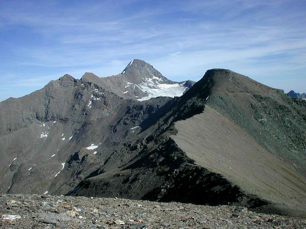 |
La Punta del Tessonet trae il suo nome dall'attiguo Ghiacciaio di Tessonet, una volta chiamato anche Doreire o Dorère, che la fascia sul suo Versante Sud risalendo fino alla piramide della Tersiva. In forma di piccola freccia triangolare leggermente adagiata ad Oriente, costituisce un nodo topografico alquanto importante; dalla sua Sommità discendon due ramificazioni significative nella struttura di questo gruppo di montagne. La prima é rivolta a Nord ed, a guisa d'una Y della quale lei ne costituisce la base, forma lo spartiacque tra i Valloni di Saint Marcel (Ovest) e nel lato opposto di Fénis-Clavalité-Alta Comba Tersiva; i due vertici son costituiti dal Montroux a Nord-nordovest e dal Mont Saint Julien a Nord-nordest. Il nodo divisorio di questi due rami é situato nel Mont Courquet (2529 m), grande cupolone erboso-roccioso, affacciantesi qual grande balconata sulla Valle Centrale del Fiume Dora Baltea. L'altra sua ramificazione risulta ancor più vasta ed importante: in questo caso la Punta del Tessonet costituisce la base d'un grande albero, la chioma del quale s'allarga da Nord a Nordovest per infine piegare a Sud e Sudovest con arco di oltre 270° circa e, se consideriamo la "trave" orizzontale di cui dopo, a 360° completi. Infatti vari nodi topografici si dispiegano, con l'andamento di cui sopra, inviando dorsali a raggiera tali da raggiungere la Valle Centrale della Dora, la Città di Aosta. il Comune di Aymavilles, all'imbocco della Valle di Cogne, e Cogne medesima e, tornando all'indietro a Settentrione, il suo Vallone del Grauson. Avremo dapprima un asse, tale da costituire il "tronco" di questa grande pianta, formato dal Colletto Tessonet, Punta Gianni Vert, due Punte di Laval, Colle di Saint Marcel o Corona's, Mont Vallonet e colle ed infine Punta di Leppe. Da qui l'albero s'"apre" ed allarga i suoi rami che, sempre con l'orientamento sopra citato, danno adito a:
a)- ramificazione della Catena delle Roèses, terminante con la Becca e la Tour di Salé, sopra il Comune di Grand Brissogne.
b)- ramificazione verso il Gruppo dell'Emilius, formata da molti snodi, che termina nel suo braccio destro a Nord-nordovest, ovvero al Mont Père Laurent sopra i Comuni di Grand Brissogne e di Pollein ed in quello sinistro, più "monco", alla Becca di Nona, sopra i Comuni di Pollein e Charvensod, alla periferia Meridionale di Aosta.
c)- ramificazione dall'Emilius dapprima verso Sud comprensiva Punta Rossa, Mont Valaisan, Punta Garin ed il suo lungo Contrafforte Sud-sudovest discendente alla Punta di Arpisson, sopra il Villaggio Turistico di Gimillan.
d)- ramificazione interna dalla Punta Rossa riunentesi in asse Ovest/Est nuovamente alla Punta di Leppe, qual grande trave di sostegno orizzontale all'interno dell'albero medesimo.
e)- piccolo ramo interno tra la Garin e la Tour Grauson.
f)- grande ramo, in successione ed a raggiera, dal Mont Valaisan alla Punta della Valletta verso Sudovest e da questa a Nord fino alla Punta del Dard sopra il Comune di Charvensod ed a Nordovest verso la cresta spartiacque, tra i Comuni di Gressan, Jovençan ed Aymavilles e la Valle di Cogne, che finisce con la Punta de la Pierre. Questi due rami formano la Conca, nonché Bacino Turistico, di Pila, famoso per lo sci.
g)- appendice secondaria ed interna, che dal Mont Ròss de Comboé compone il Contrafforte Sud-sudovest del Monte Emilius e terminante con il Trident de Comboé sovra Vallone, Rifugio e due Laghi d'Arbolle.
Tutto questo origina il nodo della Punta di Tessonet, posta appena a Nordovest della piramide della Tersiva (3513/5 m).
"Hide in the Shadows, and from there I prevent Step" / "Mi scondo nell'Ombra impedendo qualsiasi Passaggio",
by livioz
a)- ramificazione della Catena delle Roèses, terminante con la Becca e la Tour di Salé, sopra il Comune di Grand Brissogne.
b)- ramificazione verso il Gruppo dell'Emilius, formata da molti snodi, che termina nel suo braccio destro a Nord-nordovest, ovvero al Mont Père Laurent sopra i Comuni di Grand Brissogne e di Pollein ed in quello sinistro, più "monco", alla Becca di Nona, sopra i Comuni di Pollein e Charvensod, alla periferia Meridionale di Aosta.
c)- ramificazione dall'Emilius dapprima verso Sud comprensiva Punta Rossa, Mont Valaisan, Punta Garin ed il suo lungo Contrafforte Sud-sudovest discendente alla Punta di Arpisson, sopra il Villaggio Turistico di Gimillan.
d)- ramificazione interna dalla Punta Rossa riunentesi in asse Ovest/Est nuovamente alla Punta di Leppe, qual grande trave di sostegno orizzontale all'interno dell'albero medesimo.
e)- piccolo ramo interno tra la Garin e la Tour Grauson.
f)- grande ramo, in successione ed a raggiera, dal Mont Valaisan alla Punta della Valletta verso Sudovest e da questa a Nord fino alla Punta del Dard sopra il Comune di Charvensod ed a Nordovest verso la cresta spartiacque, tra i Comuni di Gressan, Jovençan ed Aymavilles e la Valle di Cogne, che finisce con la Punta de la Pierre. Questi due rami formano la Conca, nonché Bacino Turistico, di Pila, famoso per lo sci.
g)- appendice secondaria ed interna, che dal Mont Ròss de Comboé compone il Contrafforte Sud-sudovest del Monte Emilius e terminante con il Trident de Comboé sovra Vallone, Rifugio e due Laghi d'Arbolle.
Tutto questo origina il nodo della Punta di Tessonet, posta appena a Nordovest della piramide della Tersiva (3513/5 m).
by livioz
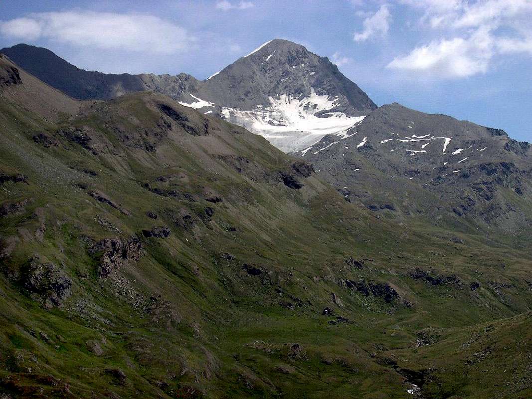 |
I climbed only once on the Punta del Tessonet and it's been almost twenty years. It was 27 August 1994 when, starting from Les Druges Hamlet (1676 m) with Lamazzi said Joseph "Peppino" go back along the Walloon of Saint Marcel, current Hunting Reserve of the Marquis Turati and former reserve the Ancient and Noble Baron Peckoz Gressoney, to reach the House Hunting Grande Chaux (2370m), is a beautiful three-hour walk, and if you do not waffle, time never passes. We chat. From here, always with the path n ° 4 and heading Southwest, you enter the Walloon Fenetre and climb to the Saint Marcel Hill or Corona (2913m), because dedicated to the famous Mountaineer Joseph Corona, in 1875, crossed it with his group first in Winter from Cogne to Saint Marcel. For which what is now, to English, Corona 's Pass, ie by the Corona, had aroused much impression at that time his company . With a final diagonal between "Ollari Stones" (stone of blue color much sought after for local sculptures and carvings) we reach the hill. And they are another couple of hours. Always chatting. And sweating . From this we "eat" the two Tops of Laval and Gianni Vert and go down to the Collar Tessonet (3051m). Here the other time with Marco Cossard , called "Crevassino" (+ 16th January 2013) we had turned around. It was June 29th, 1973 and that the Dromedary "Crevasse" had decided to go for the crest Tersiva and then doing the route in reverse, to climb the Leppe's Point, get off to the Lakes Lussert, climb to the Col des Laures, navigate to that of Arbolle and one of the "Three Capuchins" and to go up to Emilius to make the Fires of Peter and Paul with the Band Zulian and Grand Brissogne. Not reached neither the one nor the other. Who wants too! When the "Crevassino also Little Crevasse" saw the crest of Tessonet until the Tersiva, had suffered an afterthought. As a retired Army General of the Troop and immediately changed the Program. "It goes straight to the Emilius!". A small thing, just that it was necessary to climb over the other three walloons: Lussert, Laures and Arbolle, which, with that of Saint Marcel, become four. Things to two pennies, for the Ship of the Desert. Ah, of course, passing for Summits Leppe and Lussert. "Commands!", and you go. But the Army falls to 150 meters in the dark of Emilius. Defeat! Nothing Fires of Peter and Paul. For this year ...
"This is Great Chaux and behind there is the Punta del Tessonet. What a way to go to the Tersiva and Emilius!",
by Osw
Not this time. The "Pepin" and I have a better idea: you go to Point of Tessonet (3266m), which we have never gone up, and that's it. Enough. The General, who, when it comes to sharp ridges and cliffs, has Memory of an Elephant is not. He did not go to taste. So the "Pepin" and I are alone. Without Command. But the Devil is less ugly as he is painted. Turning a little to the North, then a little to the South between rocks exposed in this direction, trite to say the speed, and passing a small plaque at the end we Tessonet. Doing a little bit of attention, especially downhill. There are many. He said to us, in return, Gamekeeper Osvaldo Pianfetti said "Yogi", who also died in this year. Even many hunters, and he knew it well because there had spent twenty-plus years of his Life ...
But as it was considered to be the ascent of this mountain almost a Century and a half ago? They tell us our tutelary Numens that B&V in "Guide of the Western Alps", 1896, on page 65: "... then you reach the top - m. 3263 - with a rather arduous climb for an hour on the western ridge of the peak. ridge north it is more difficult, it leads to the glacier mentioned that it is very steep and wider than that is not apparent from below ... ". Our take also into account the Coast also Crest of Tessonet (altitudes 3188, 3213, 3315, 3273, 3280, 3305 and 3327 meters), which is the continuation (see photo below) between Point of Tessonet to Tersiva's Collar (3310m) and the same. Wonder how expanding the Northern Glacier Tessonet in the Walloon of Saint Marcel, now reduced to a snowfield, which reached the height of North Ridge completely from the moraines overlying Grande Chaux.
"I'm a Sentinel Invincible to arrive at the Court of King Arthur" / "Son Sentinella Invincibile per giunger a Corte del Re Artù",
by zed
by Osw
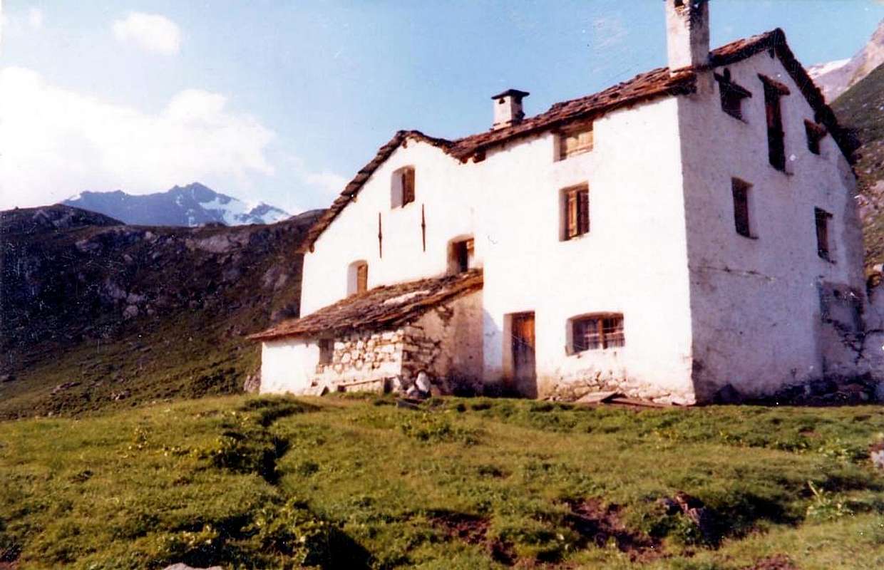 |
Not this time. The "Pepin" and I have a better idea: you go to Point of Tessonet (3266m), which we have never gone up, and that's it. Enough. The General, who, when it comes to sharp ridges and cliffs, has Memory of an Elephant is not. He did not go to taste. So the "Pepin" and I are alone. Without Command. But the Devil is less ugly as he is painted. Turning a little to the North, then a little to the South between rocks exposed in this direction, trite to say the speed, and passing a small plaque at the end we Tessonet. Doing a little bit of attention, especially downhill. There are many. He said to us, in return, Gamekeeper Osvaldo Pianfetti said "Yogi", who also died in this year. Even many hunters, and he knew it well because there had spent twenty-plus years of his Life ...
But as it was considered to be the ascent of this mountain almost a Century and a half ago? They tell us our tutelary Numens that B&V in "Guide of the Western Alps", 1896, on page 65: "... then you reach the top - m. 3263 - with a rather arduous climb for an hour on the western ridge of the peak. ridge north it is more difficult, it leads to the glacier mentioned that it is very steep and wider than that is not apparent from below ... ". Our take also into account the Coast also Crest of Tessonet (altitudes 3188, 3213, 3315, 3273, 3280, 3305 and 3327 meters), which is the continuation (see photo below) between Point of Tessonet to Tersiva's Collar (3310m) and the same. Wonder how expanding the Northern Glacier Tessonet in the Walloon of Saint Marcel, now reduced to a snowfield, which reached the height of North Ridge completely from the moraines overlying Grande Chaux.
by zed
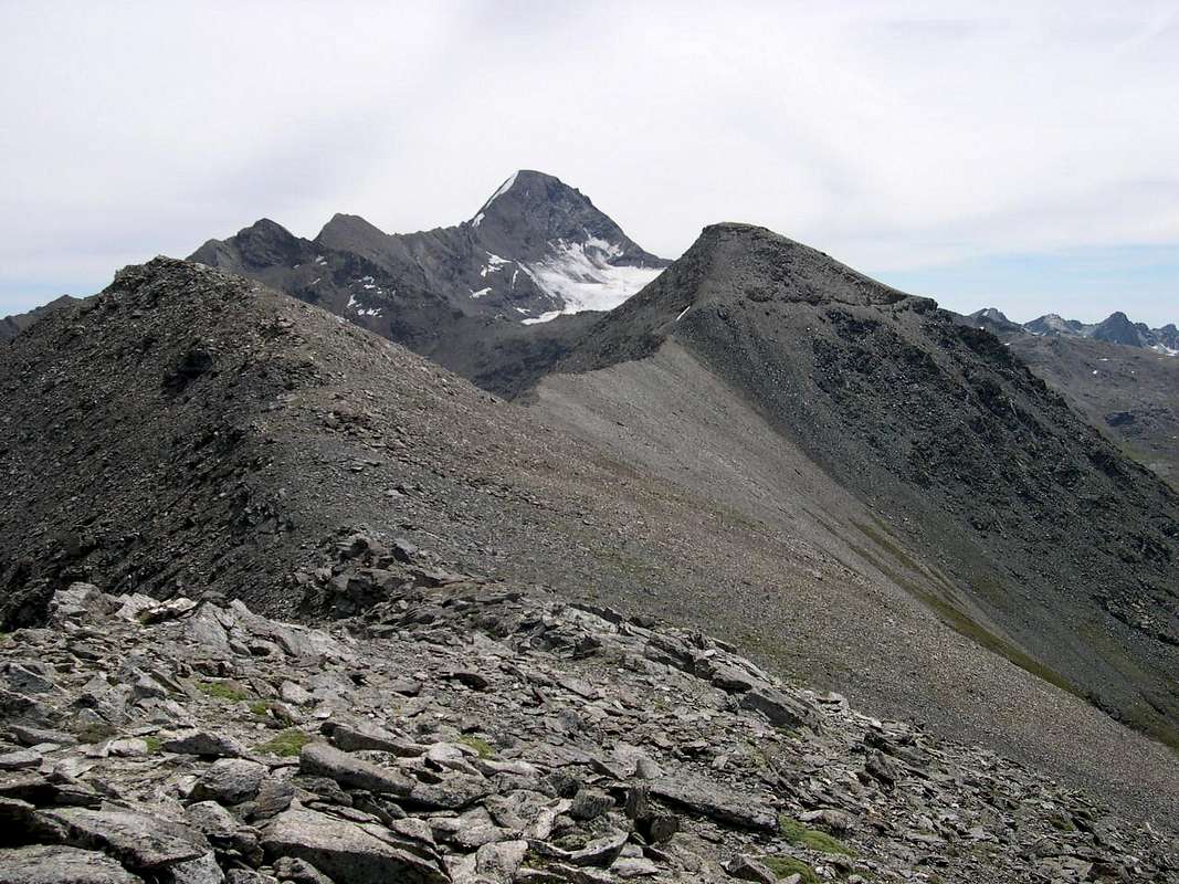 |
Son salito un'unica volta sulla Punta del Tessonet e son passati quasi venti anni. Era il 27 di Agosto del 1994 quando, partendo da Les Druges (1676 m) con Giuseppe Lamazzi detto "Peppino" risaliamo il lungo Vallone di Saint Marcel, attuale Riserva di Caccia del Marchese Turati ed ex Riserva dell'antico e nobile Barone Peckoz di Gressoney, per raggiungere la Casa di Caccia di Grande Chaux (2370 m); é 'na bella camminata di tre ore e, se non chiacchieri, il tempo non passa mai. Noi chiacchieriamo. Da qui, sempre col sentiero n° 4 e con direzione Sudovest, si entra nel Vallone Fenetre e si sale al Colle di Saint Marcel o di Corona (2913 m), perché dedicato al famoso Alpinista Giuseppe Corona che, nel 1875, lo attraversò con la sua comitiva per primo in Inverno da Cogne a Saint Marcel. Per la qual cosa é divenuto, all'Inglese, Colle Corona's, cioé di Corona, tant'aveva suscitato impressione a quei tempi la sua Impresa. Con un ultimo diagonale tra "Pietre Ollari" (pietra di color blù molto ricercata per le locali sculture ed intagli) giungiam al colle. E son n' altro paio d'ore. Sempre chiacchierando. E sudando. Da questo ci "mangiamo" le due Punte di Laval e la Gianni Vert e scendiamo al Colletto Tessonet (3051 m). Qui l'altra volta insieme al Marco Cossard, detto "Crevassino" (+ 16 Gennaio 2013) avevam fatto dietro front. Era il 29 Giugno 1973 e quel Dromedario del "Crevasse" aveva deciso d'andar per cresta alla Tersiva e poi, facendo il percorso all'inverso, di salir la Punta di Leppe, scender ai Laghi di Lussert, salir al Col des Laures, traversar a quello di Arbolle ed a quello dei "Tre Cappuccini" ed andar sù all'Emilius a far Fuochi di Pietro e Paolo con la Banda di Zulian e di Grand Brissogne. Non raggiungemmo né l'una, né l'altro. Chi troppo vuol! Quando il "Crevassino o Piccola Crepaccia" vide la Cresta del Tessonet fin alla Tersiva, ebbe subito ripensamento. Come un Generale d'Armata ritirò la Truppa e cambiò subito Programma. "Si va subito allo Emilius!". 'Na cosettina, sol ch'era necessario scavalcar altri tre vallon: di Lussert, delle Laures e dell'Arbolle, che, con quel di Saint Marcel, diventan quattro. Cosette da due soldi, per la Nave del Deserto. Ah, logicamente, passando anche per le Punte di Leppe e di Lussert. "Comandi!", e si va. Ma l'Armata crolla a 150 metri nel buio dell'Emilius. Disfatta! Niente Fuochi di Pietro e Paolo. Per questo anno ...
"On the left the Tersiva, right Emilius, in front Garin Peak. Where to?" / "A sinistra la Tersiva, a destra l'Emilius, davanti la Garin. Dove si va?",
by Marco Cossard "Crevassino"
Questa volta no. Il "Pepin" ed io abbiam idee più chiare: si va alla Punta del Tessonet (3266 m), che non abbiam mai salito, e basta. Basta che avanza. Il General, che, quando si tratta di creste affilate e strapiombi, possiede Memoria d'Elefante non vien. Non gli vanno a gusto. Così il "Pepin" ed io siamo soli. Senza Comando. Ma il Diavolo é men brutt di come lo si dipinge. Passando un poco al Nord, poi un pò al Sud tra rocce esposte in questa direzion, trite per non dir marce da far schifo, e superando 'na placchetta final siam al Tessonet. Facendo un poco d'attenzione, soprattutto in discesa. Non ci vengono in molti. Lo diceva a noi, al ritorno, il Guardiacaccia Osvaldo Pianfetti detto "Yogi", anche lui morto in questo anno. Neppur tanti Cacciador, e lui lo sapeva ben perché lì aveva trascorso venti e più anni della sua Vita ...
Ma com'era cosiderata la salita di questa montagna quasi un Secolo e mezzo orsono? Ce lo dicon i nostri Numi tutelari B&V che in "Guida delle Alpi Occidentali", 1896, alla pagina 65: " ... quindi si raggiunge la sommità - m. 3263 - con una scalata piuttosto ardua un'ora su per la cresta occidentale del picco. La cresta nord ne é più difficile; essa conduce al ghiacciaio accennato che é assai scosceso e più vasto di quello che non paia dal basso ... ". I nostri prendono, inoltre, in considerazione la Cresta o Costa del Tessonet (quote 3188, 3213, 3315, 3273, 3280, 3305 e 3327 metri), chè é la continuazione (vedi foto sotto) tra la Punta di Tessonet verso il Colle della Tersiva (3310 m) e la stessa. Fa meraviglia di come s'espandeva il Ghiacciaio Settentrionale di Tessonet nel Vallone di Saint Marcel, oggi ridotto a nevato, che raggiungeva il colmo della Cresta Nord completamente dalle morene soprastanti Grande Chaux.
"This ridge, you see, it will never be raped. I swear on my Honor!" / "Questa cresta, che tu vedi, non sarà mai violentata. Te lo giuro sul mio Onor!",
by Gino Bolfo
by Marco Cossard "Crevassino"
 |
Questa volta no. Il "Pepin" ed io abbiam idee più chiare: si va alla Punta del Tessonet (3266 m), che non abbiam mai salito, e basta. Basta che avanza. Il General, che, quando si tratta di creste affilate e strapiombi, possiede Memoria d'Elefante non vien. Non gli vanno a gusto. Così il "Pepin" ed io siamo soli. Senza Comando. Ma il Diavolo é men brutt di come lo si dipinge. Passando un poco al Nord, poi un pò al Sud tra rocce esposte in questa direzion, trite per non dir marce da far schifo, e superando 'na placchetta final siam al Tessonet. Facendo un poco d'attenzione, soprattutto in discesa. Non ci vengono in molti. Lo diceva a noi, al ritorno, il Guardiacaccia Osvaldo Pianfetti detto "Yogi", anche lui morto in questo anno. Neppur tanti Cacciador, e lui lo sapeva ben perché lì aveva trascorso venti e più anni della sua Vita ...
Ma com'era cosiderata la salita di questa montagna quasi un Secolo e mezzo orsono? Ce lo dicon i nostri Numi tutelari B&V che in "Guida delle Alpi Occidentali", 1896, alla pagina 65: " ... quindi si raggiunge la sommità - m. 3263 - con una scalata piuttosto ardua un'ora su per la cresta occidentale del picco. La cresta nord ne é più difficile; essa conduce al ghiacciaio accennato che é assai scosceso e più vasto di quello che non paia dal basso ... ". I nostri prendono, inoltre, in considerazione la Cresta o Costa del Tessonet (quote 3188, 3213, 3315, 3273, 3280, 3305 e 3327 metri), chè é la continuazione (vedi foto sotto) tra la Punta di Tessonet verso il Colle della Tersiva (3310 m) e la stessa. Fa meraviglia di come s'espandeva il Ghiacciaio Settentrionale di Tessonet nel Vallone di Saint Marcel, oggi ridotto a nevato, che raggiungeva il colmo della Cresta Nord completamente dalle morene soprastanti Grande Chaux.
by Gino Bolfo
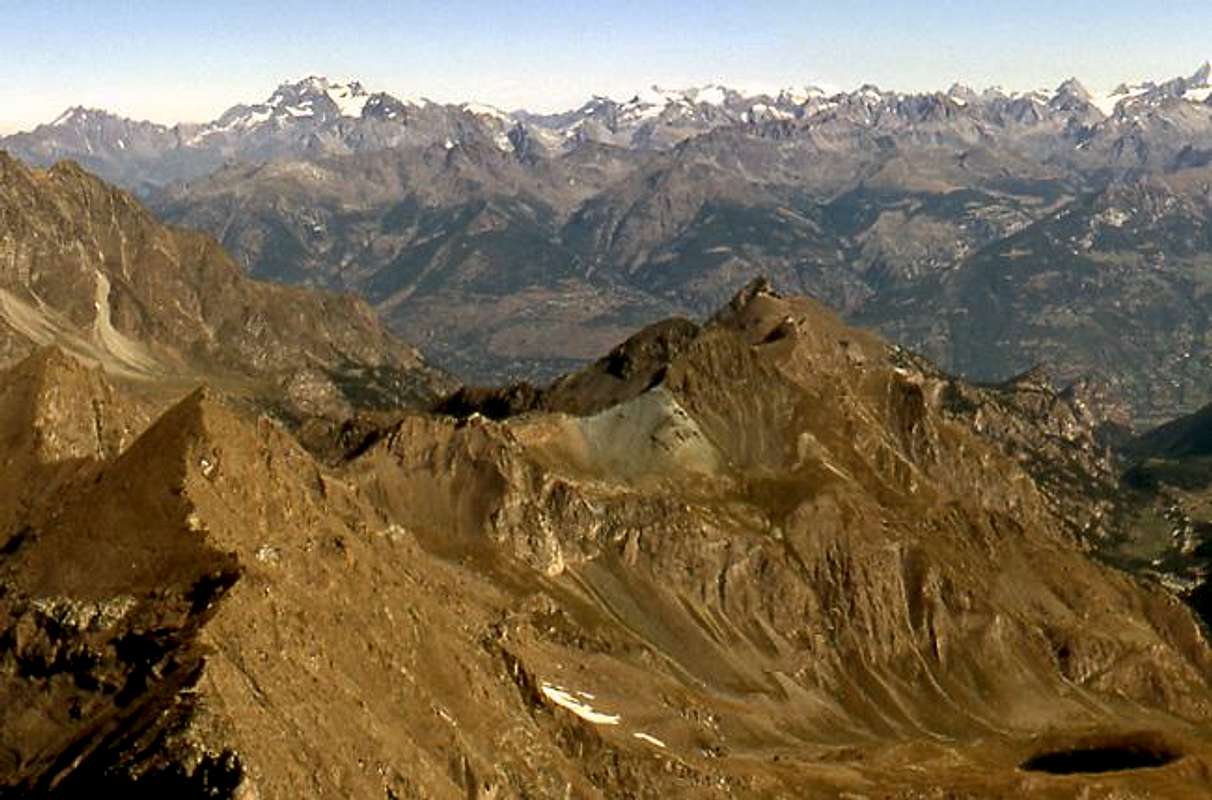 |
"Tell me or MIRROR of My CRAVINGs, Who is the fairest of them all. Petit Avert or I?"
Of these two Mountains I want to tell you Three Stories. Three True Stories, which are outside the Joke or the Legend, but rather reflect a lived reality. One is addressed to the Grand Avert, climbed under a Lightning Thunderstorm with large, two at Petit with a stunning climb after a night snowfall but encountering, to return almost to the end of the descent, the Viper of Species "Marassus Collericum" aggressor, if irritated , the man and another of a "double" ascent from Lavodilec's Hill.
<Mirror of Longingsts>
"I am the Grand Avert. There is no question. But when ever it is heard that a little can compete with a Great. Even in the Sea Fish Big eats small fish ...",
by emilius
"I am the Grand Avert. There is no question. But when ever it is heard that a little can compete with a Great. Even in the Sea Fish Big eats small fish ...",
by emilius
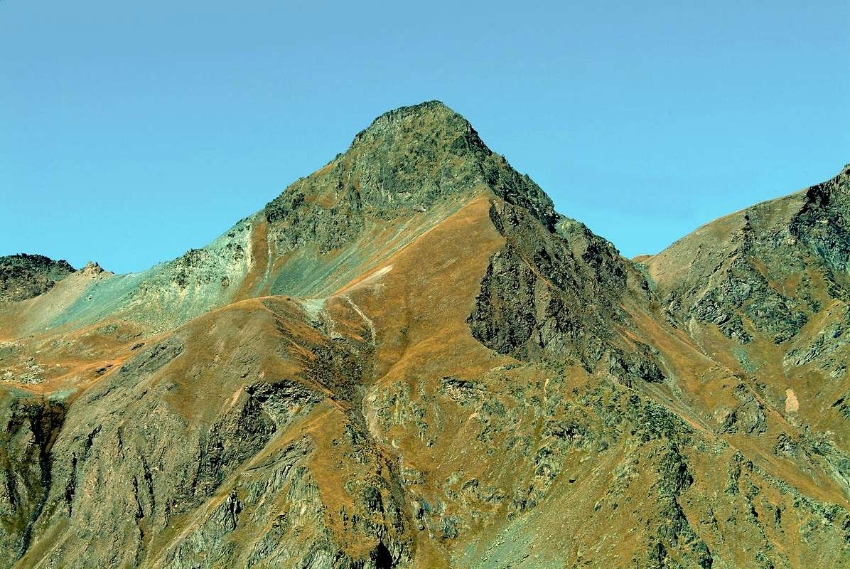 |
Di queste due Montagne voglio raccontarvi Tre Storie. Tre Storie Vere, che esulano lo Scherzo o la Leggenda, bensì riflettono una realtà vissuta. Una é rivolta al Grand Avert, salito sotto un Temporale con grandi Fulmini, due al Petit con una splendida salita dopo una nevicata notturna ma incontrando, al ritorno quasi al termine della discesa, la Vipera della Specie "Marassus Collericum" che aggredisce, se irritato, anche l'uomo; un'altra di una "doppia" salita dal Colle di Lavodilec.
"Anywhere you look at me, you see, are squat and massive. But how can this little guy to make comparisons with Me? ...",
by emilius
by emilius
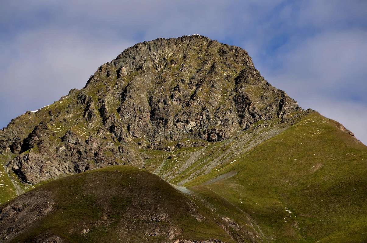 |
Already coming to Grande Chaux (2370m), the path along the Walloon of the Village of Saint Marcel Les Druges High (1567 m), it is not that time is a show. Black clouds pregnant with rain coming from the East and Southeast, from Graian. We stop at the House Hunting of the Marquis Turati, formerly owned by the Baron Beck Peckoz, to have breakfast at the beautiful fountain. The Great Avert he looks dark and threatening. What to do? You have breakfast, then we'll see "Antea edere, deinde philosophare". The Gamekeeper not there. We do not see a living soul. Finished, we take to rise. We cross towards Little Chaux Pasture (2419 m), follow it for a short time the Torrent de Saint Marcel then, turning to the left, we enter a small walloon secondary and the Intervalleys path No. 102 to the Col Lavodilec climb up to 2658 meters crossroads; here abandon him and another less pronounced, which is subsequently lost in a track in the stone, we trudge towards a saddle unnamed, locally called Colle di Terre Bleue (2830m). Meanwhile the weather worsens and when the reach is really dark blue, like the sky above it.
Meanwhile the weather worsens and when the raggiungiam is really dark blue, like the sky above it. The "Pepin" is somewhat doubtful but then lets himself be convinced to go aloft, so we attack the rump blue towards the Summit, which appears here in the form of a shark's tooth. One step after another, a heavy step and without enthusiasm, we carry the base of the rocky wall of the Edge Southwest. Let's start with a short time the climb that breaks the Thunderstorm. Violent. You go on the same "Ca cousta l'on cà cousta, Viva Aousta", that is "Whatever It Takes, Long live the Aosta" (motto of the Alpine Troops Battalion in the First World War). Up to a certain point. Because when we come to a small corner steep, with grass and exposed, where the water runs down like a torrent, the "Pepin" sends me to the Devil and watched for a little while my climb back down. There is no chance to make it go up. There is no flattery. He shakes his head and walks away. I'm going up. Among the crackle of lightning to Summit. More cautiously I also go down and run to Terre Bleue Hill, which is no longer blue but black as the sky ...
"To resolve this Dilemma, the "Peppino" and I go to check where is the Reason. So from Col de Terre Bleue we go to the Crest Southwest. We decide for a comparative analysis, which is not the Merit "Compare" (Godfather)! ...",
by Osw
"Ma ove te voto andar, Mona, cò stò Tempasssccc!" / "But where do you go, Stupid, with a Baaadddd Weather, like this! ...",
by Osw
Meanwhile the weather worsens and when the raggiungiam is really dark blue, like the sky above it. The "Pepin" is somewhat doubtful but then lets himself be convinced to go aloft, so we attack the rump blue towards the Summit, which appears here in the form of a shark's tooth. One step after another, a heavy step and without enthusiasm, we carry the base of the rocky wall of the Edge Southwest. Let's start with a short time the climb that breaks the Thunderstorm. Violent. You go on the same "Ca cousta l'on cà cousta, Viva Aousta", that is "Whatever It Takes, Long live the Aosta" (motto of the Alpine Troops Battalion in the First World War). Up to a certain point. Because when we come to a small corner steep, with grass and exposed, where the water runs down like a torrent, the "Pepin" sends me to the Devil and watched for a little while my climb back down. There is no chance to make it go up. There is no flattery. He shakes his head and walks away. I'm going up. Among the crackle of lightning to Summit. More cautiously I also go down and run to Terre Bleue Hill, which is no longer blue but black as the sky ...
by Osw
 |  |  |  |
by Osw
Già arrivando al Gran Chaux (2370 m), fatto il lungo Vallone del Saint Marcel dal Villaggio di Les Druges Alte (1567 m), non é che il tempo fosse 'no spettacolo. Nere nuvole gravide di pioggia arrivavano dall'Est e dal Sudest, dall'Alpi Graie. Ci fermiam presso la Casa di Caccia del Marchese Turati, ex proprietà del Baron Beck Peckoz, per far colasion, presso 'na bella fonte. Il Grand Avert ce scorcia tenebroso e cativo. Che far? Se fa colasion, poi vedrem "Antea edere, deinde philosophare!". Il Guardiacaccia non ghe s'é. Non vediam anima viva. Finito, prendiamo salir. Attraversiam verso le Malghe del Petite Chaux (2419 m), seguiam per poco tempo il Torrent de Saint Marcel poi, svoltando sinistra, entriam in un valloncel men important e col sentiero Tra le Valli n° 102 pel Col Lavodilec montiam fin'al bivio 2658 metri; qui l'abbandoniam e con altro men chiaro, che poi si sperde in 'na traccia indentro la pietraia, arranchiam verso 'na sella innominata, localmente chiamata Colle di Terre Bleue (2830 m). Nel frattempo il tempo comincia a scarseggiar'lteriormente e quando la raggiungiam é veramente blù scuro, com il ciel che sta sovra. Il "Pepin" é alquanto dubioso ma poi si lascia andar ad 'ndar sù; così tacchiam la groppa blù verso la Sommità, che da qui appar a forma d'un dentin di squalo. Un passo dietro l'altro, pesante e senz'alegria, ci portiam alla base del salton roccioso della Cresta Sudovest, qui in forma di spigolettin. Non facciam tempo cominciar che si scaten'el Tempural. Viulent. Si va sù lo stesso "Ca cousta l'on cà cousta, Viva l'Aousta ", cioé "Costi quel che costi, Viva l'Aosta" (motto del Battaglione degli Alpini nella Prima Guerra Mondiale). Fin an certo punto. Perché quando arriviam ad un diedrin ripido, merdoso d'erba ed esposto, dove l'acqua va dzò com'un torrent, il "Pepin" mi mand'al Diavolo e, guardato per pochettin il mio salir, va giù. Non c'é speranza farlo montar. Gnanche la lusinga. Scuote la testa e sen va. Io salgo. Tra lo scoppiettar dei fulmini giungo in Vetta. Più prudentemente scendo e scapp'anch'io al Col di Terre Bleue, che non l'é più blù ma ner, com'el ciel ...
" View this photograph, honestly, we're even. Draw: X. ...",
by Antonio
by Antonio
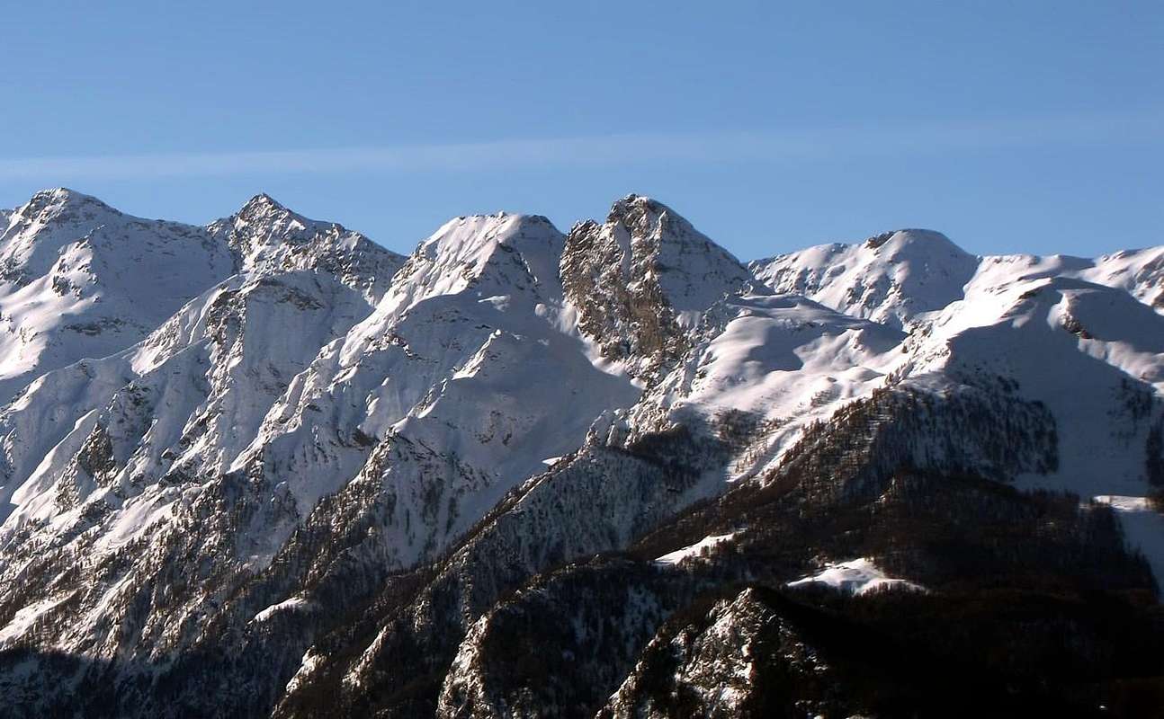 |
The Summer 1994 is ending: September 18th is when the "Peppino" walk the long Walloon Fénis-Clavalitè, to the East of the divide between the Point of Tessonet and the two Avert. We go to Little Avert (2947m), which we never did, even to take a look at Lake Lavodilec (2357m), which call themselves wonders. During the night it snowed and the snow is also abundant. Without getting to the bottom of the farm Alpage Grand Alpe (2129m; excellent whole cheese "Fontina"!), Take the fork immediately after the Alp Meney Damon (1929m) and with a small path, not numbered and in the semi-circular form, we connect to the diagonal that n° 7/102 comes from Grand Alpe Pastures; passing through Alp in forfeiture of Lavodilec (2264m) and focusing strongly in short we in the West to the lake. Truly wonderful! Colors ranging from green to turquoise blue. With this direction, and with a long diagonal, due to the snow, we should go further up against a rocky area near to one grassy-rocky rampart, we climb with care, in the last stretch back up against the rocks and with a short diagonal to the left, often sinking in deep snow, we to Lavodilec's Hill (2963m). Everything below is a special whiteness, with the snow that shine and begin to melt. The day is beautiful and the sky, which stands above the Point of Tessonet, looks like a postcard hanging on the blue sky. In short, at first through the Southwest Slope to the left and then placing in the final section to the West-northwest Ridge, which rises from Petite Chaux Pastures, we reach the quota 2808 meters altitude on the same, and then the Summit of the Petit Avert (2947m). Lovely day out. We eat and we go down, this time going down the steepest slope. But when we arrive and we are almost at the bottom to reach the private dirt road on the floor valley, just as we are traveling with that sprightly rhythm in the mountains makes you seem to operate in unison, where the trail with a beautiful staircase hewn stone, invites to go even faster, just in the finishing straight, here is the Little Surprise! A viper is raised vertically between the legs of the "Peppino", that not even realize it. I, who almost glued behind the trip, I do not even time to warn him, because now it's up to me. With a flash prodigious, worthy of better times, the jump ... and not fall even him to "Pepin", which is already over. When you cry, "Viper, viper!", She is already crawling towards a broad furrow and dried torrential, just to the side. The "Pepin" begins to throw stones, "Berta Bicia, bert Bicia" (ugly beast, beast). The excitement does exclaim in "patois" (dialect French/Provençal of the Aosta Valley), rather than in Italian. He that is of Pavullo, Emilia Romagna! The viper, already far away of a ten meters and within the furrow, suddenly turns around and, with a change of direction of travel and worthy of the best handball player or basketball, if you prefer, pointing right at us. Back to top that looks like a "Littorina (Italian train of the Fifties). Letting go of the bags we give to flee. Alia, that: "Berta Bicia, now I'll show you". And she was right, because not only did not bitten, but, in addition, we have broken the bales!
We'll know, but then, that area of the two Avert lives and thrives, perhaps the only place in the world because this reptile is timid in nature and if it does not bite pests, the "Marassus Collericum" or "Viper Angry", which annoyed , is not afraid to attack humans, especially when they make Stupid Actions ...
"Looking at this Picture, there is no comparison, because it sees only the Terre Bleue Pass. But it appears the Lake Lavodilec and then you understand that the Little Noble is ...",
by emilius
We'll know, but then, that area of the two Avert lives and thrives, perhaps the only place in the world because this reptile is timid in nature and if it does not bite pests, the "Marassus Collericum" or "Viper Angry", which annoyed , is not afraid to attack humans, especially when they make Stupid Actions ...
by emilius
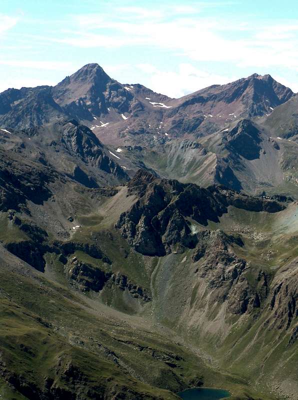 |
L'Estate 1994 sta finendo: é il 18 di Settembre quando col "Peppino" percorriamo il lungo Vallone di Fénis-Clavalitè, ad Est dello spartiacque tra la Punta del Tessonet ed i due Avert. Noi andiamo al Petit (2947 m), che non abbiam mai fatto, anche per dar un'occhiata al Lago di Lavodilec (2357 m), del quale si dicon meraviglie. Nella notte ha nevicato ed il manto é anche abbondante. Senza arrivare fino in fondo alla poderale all'Alpeggio di Grand Alpe (2129 m; ottima Fontina!), prendiamo il bivio subito dopo l'Alpe di Meney Damon (1929 m) e con piccolo sentiero, non numerato e dal percorso semicircolare, ci colleghiamo a quello diagonale che arriva da Grand Alpe o n° 7/102; passando dall'Alpe in decadenza di Lavodilec (2264 m) e puntando decisamente ad Ovest, in breve, siamo al lago. Veramente splendido! Dai colori che van dal verde turchese all'azzurrino. Con questa direzione e con un lungo diagonale che, causa la neve alta, ci conviene percorrere più in alto contro una fascia rocciosa raggiungiamo uno spalto roccioso-erboso, che saliamo con precauzione; nell'ultimo tratto torniamo in alto contro le rocce e con un breve diagonale a sinistra, affondando spesso nella neve alta, siamo al Colle di Lavodilec (2963 m). Tutto al di sotto é d'un candore speciale, con le nevi che brillano ed incominciano a fondersi. La giornata é splendida ed il cielo, stagliantesi sopra la Punta del Tessonet, sembra una cartolina azzurra appesa alla volta celeste. In breve, dapprima attraversando il Versante Sudovest verso sinistra e poi appoggiando nella parte finale alla Cresta Ovest-nordovest, che sale dalla Petite Chaux, raggiungiamo la quota 2808 metri sulla medesima, e successivamente la Vetta del Petit Avert (2947 m). Bella gita. Mangiamo e discendiamo, questa volta calando per la massima pendenza. Ma quando arriviam quasi in fondo e stiam per raggiunger la strada poderale sul fondo valle, proprio mentre viaggiamo con quel pimpante ritmo che in montagna ti fa sembrar d'andar all'unissono, dove il sentiero, con una bella gradinata in pietra squadrata, invita a calar ancor più veloci, proprio in dirittura d'arrivo, ecco la Sorpresina! Una vipera s'alza in verticale in mezzo alle gambe del "Peppino", che neppur se n'accorge. Io, che gli viaggio quasi al culo, non faccio neppur tempo ad avvisarlo, perché tocca subito a me. Con colpo di reni prodigioso, degno dei tempi migliori, la salto ... e non casco neppur addosso al "Pepin", ch'é già oltre. Quando grido: "Vipera, vipera!", lei sta già strisciando verso un largo ed essiccato solco torrentizio, appen a lato. Il "Pepin" comincia a tirar sassi: "Berta bicia, berta bicia" (brutta bestia, brutta bestia). L'emozione lo fa esclamare in patois (dialetto Franco/Provenzale della Val d'Aosta), invece che in italiano. Lui ch'é di Pavullo, Emilia Romagna! La vipera, già lontana d'un dieci metri e dentro il solco, di colpo si torce e, con un cambio di senso e di marcia degno del migliore giocatore di pallamano o basket, se preferite, punta dritto contro di noi. Torna indietro che sembra 'na Littorina (treno italiano degli Anni Cinquanta). Mollando gli zaini ce la diamo a gambe levate. Altro che: "Berta bicia, mò ti faccio veder io!". Ed aveva ragione lei, perché non solo non ci'ha morsicato, ma, in più, le abbiam rotto le balle!
Sapremo, ma poi, che nell'area dei due Avert vive e prospera, fors'unico posto al Mondo perché questo rettile é di natura timido e se non lo pesti non morde, il "Marassus Collericum" o "Vipera Collerica", che, infastidita, non ha paura d'attaccar l'uomo, soprattutto quando commette Azioni Stupide ...
"Noting that there is no Probative. But serious are the Clues that is tiny, especially looking at the other Mountains ...",
by emilius
Sapremo, ma poi, che nell'area dei due Avert vive e prospera, fors'unico posto al Mondo perché questo rettile é di natura timido e se non lo pesti non morde, il "Marassus Collericum" o "Vipera Collerica", che, infastidita, non ha paura d'attaccar l'uomo, soprattutto quando commette Azioni Stupide ...
by emilius
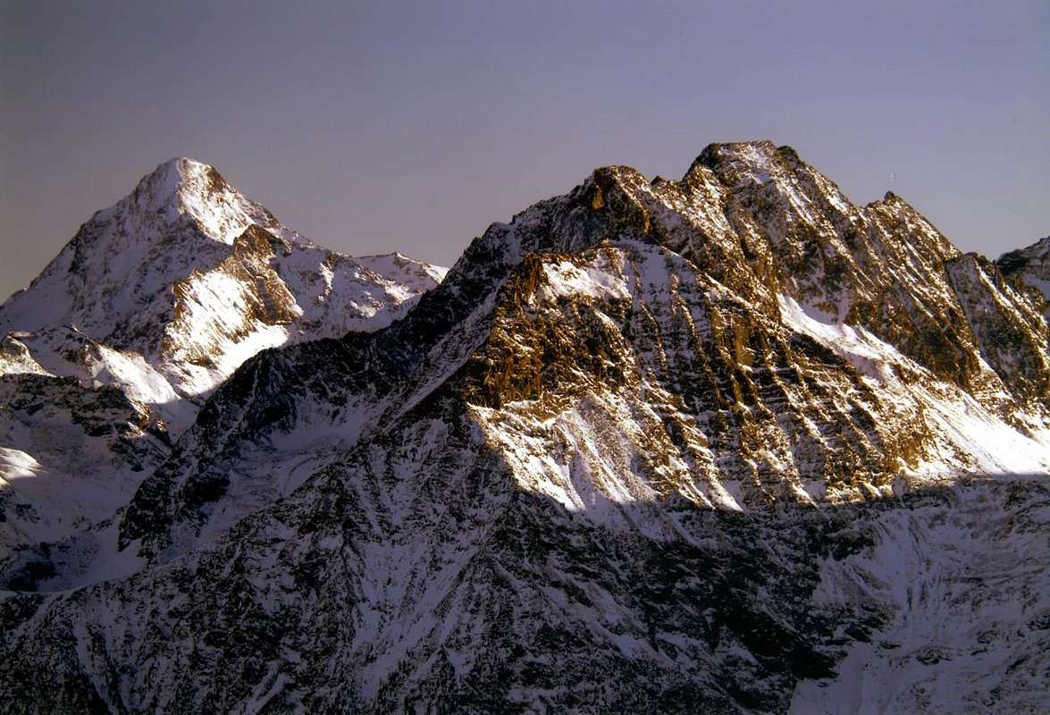 |
Return to Little Avert on August 17, 2003 (do not have to go to the mountains on this day , a "superstition" of the mountaineers so recommends, also see " The my Mountains" by Walter Bonatti, 1961). But this is a walk and we we do not care about this idea. Indeed, the two who are with me do not even know. Thankfully! Who am I? One is Gianfranco Vicentini, my Former Headmaster at School, which is in the mountains with us since 1997, and the other is the Nicholas Colajanni, Judge of the Supreme Court, as well as Professor in Bari University, who was also from 1997, ie from when it comes to making holidays Valle, host of the Gianfranco. A beautiful and heavy responsability. His? No my to have the courage to take him up the mountains. He who is Man Sea, however, already wanderer in the Dolomites. It "arranges", pretty good. I 'm not doing the long. The approach is always the same, long and exhausting, and the Petit Avert, it seems to me, has not been moved since the last time that I saw it. The Lavodilec (Lake of the Loch) is in place. Indeed, this is why we're here, to make them see the magnificent lake. However, be careful. At the "Viper Choleric"? No, to the Dean. This is how my Friend "Crevassino" ( is dead January of this year), when putting the Turbo exterminates a Camel. Nicolas instead fits, but that he "did the Via Ferrata of the Dolomites" is more a lover of Rock. To walk goes beyond imagination for someone who comes from the sea, and without training. But he does from "Disgusted". He is for the High Peaks. Headmaster no. Dislikes gullies , walls, ridges dizzy and everything appears solid and level. As the granite. If you go back, not indulged his marching beat. Do not be fooled by its low profile, since destroys you, so then there is no longer the desire to climb. Before you sit at the "salle à manger" and there "die". Day closed ! What he wants ...
With the proper introduction, we make the climb up to the lake and to Lavodilec's Hill. But the "Preside" is not able to eliminate us. Throw a "Tramontana" Wind on this "salle", that forces us in the shelter of some rocks. Here you can eat, drink, photographing and then if you want, you can even sleep. So he decided the Dean, that to go higher up does not really want to know. "With this bad wind, wherever you want to go?". He's right, but Nicola and I we're two "Stubborns". Let's go up anyway. And not for the usual Normal Route, but we go on the Southwestern Edge of the Ridge, where there are few passers. So we take even more the gusts of wind. That "Dunces"! The rock is steep, exposed, but not beautiful, because crumbly. From the pass we follow the Dean shook his head and, occasionally, by sending us a reproach. From the Summit we descend down from the Standard. We see it, is heartening. When we get to him I play the Trump Card. I convince him to go to the Peak. For the Normal. Logically. The Nico did not really want to go back upwards. Convince him well. Oh, did I just wrong Craft. I had to do the Ombudsman. So, back upwards for the second time, with the "Preside" and the Normal. Logically ...
"Photography decisive for the Verdict: The Grand is higher, but the Petit is more Noble because it owns the lake, which is not seen here as it is on the other side. Thus, the Court decided! ...",
by Zed
With the proper introduction, we make the climb up to the lake and to Lavodilec's Hill. But the "Preside" is not able to eliminate us. Throw a "Tramontana" Wind on this "salle", that forces us in the shelter of some rocks. Here you can eat, drink, photographing and then if you want, you can even sleep. So he decided the Dean, that to go higher up does not really want to know. "With this bad wind, wherever you want to go?". He's right, but Nicola and I we're two "Stubborns". Let's go up anyway. And not for the usual Normal Route, but we go on the Southwestern Edge of the Ridge, where there are few passers. So we take even more the gusts of wind. That "Dunces"! The rock is steep, exposed, but not beautiful, because crumbly. From the pass we follow the Dean shook his head and, occasionally, by sending us a reproach. From the Summit we descend down from the Standard. We see it, is heartening. When we get to him I play the Trump Card. I convince him to go to the Peak. For the Normal. Logically. The Nico did not really want to go back upwards. Convince him well. Oh, did I just wrong Craft. I had to do the Ombudsman. So, back upwards for the second time, with the "Preside" and the Normal. Logically ...
by Zed
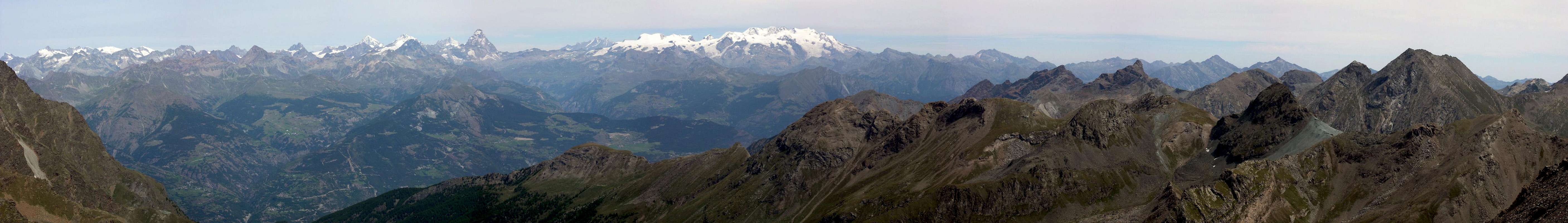 |
Torno al Petit Avert il 17 Agosto del 2003 (non si deve andar montagna in questo giorno; una "superstizione" degli alpinisti così consiglia; vedi anche "Le Mie Montagne" di Walter Bonatti, 1961). Ma questa é 'na passeggiata e noi ce ne freghiam di st'idea. Anzi i due che son con migo neppur la conoscon. Per fortuna! Chi son? Uno é il Gianfranco Vicentini, mio ex Preside a Scuola, che vien in montagna con noi dal 1997; l'altro é il Nicola Colajanni, Magistrato di Cassazione, nonché Professore d'Università a Bari, anche lui dal 1997, cioé da quando vien far ferie in Valle, ospite del Gianfranco. 'Na bella resposabilità. La sua? No la mia ad aver coraggio di portar sù per le Montagne. Lui che é Uom di Mare, però già girovago delle Dolomiti. S'"arrangia", abbastanza ben. Non ve la stò far lunga. L'avvicinamento é sempre lo stesso, lungo e spossante, ed il Petit Avert, mi sembra, non s'é mosso dall'ultima volta, che l'ho visto. Anche il Lavodilec (Lago del Lago) é a posto. Anzi, é per questo che siam qui, per far veder lor il magnifico lago. Però bisogna far attenzion. Al "Marasso Collerico"? No, al Preside. Questo é come il mio Amico "Crevassino" (é morto a Gennaio di questo anno); quando metton il Turbo stroncan anch'un Cammel. Nicola invece s'adatta, ma lui che "ha fatto le Vie Ferrate" delle Dolomiti ama più la Roccia. Per camminar procede oltre ogni immaginazion per un ch'arriva dal mar, e senza gnanch'un pel d'allenamento. Ma lo fà da "Schifà". Lui é per l'Alte Cime. Il Preside no. Odia burroni, pareti, creste vertiginose e tutto ciò che non appar solido ed in pian. Com'el granito. Se gli andé de rio, non assecondate il suo marciar. Non fatev'ingannar da suo basso profil perché ve stronca, così poi non vi vien più voglia de rampegar. Vi sedete alla prima "salle à manger" e lì "morite". Giornata chiusa! Quel che lui vuol ...
Con dovuta premessa, facciam la salita fino al Lago ed al Colle di Lavodilec. M'al Preside non é riuscì farci fora. Tira 'na Tramontana su sta "salle", che costringe al ripar d'alcuni massi. Qui si mangia, si trinca, si fotografa e poi, se vuoi, puoi anche farti un pisolin. Così ha deciso il Preside, che d'andar più sù non ne vuol proprio saper. "Con sto ventaccio, dove vuoi andare?". Gà reson lù, ma Nicola ed io che siam due "Teston", andiamo sù gualmente. E non per la solita Via Normale, bensì andiam sul fil di Cresta Sudovest, ove non passa mai nessun. Così prendiam ancora più raffiche di Vento. Che "Zuccon"! La roccia é ripida, esposta, ma non bella, perché friabil. Dal colle il Preside ci segue scotendo la testa e, di tanto in tanto, ci manda 'na rampognada. Dalla Vetta scendiam giù dalla Solita. Lo vediam, si rincuora. Quando arriviam da lù me giogo l'Asso nella Manica. Lo convinco ad andar sù in Vetta. Per la Normale. Logicamente. Il Nico non ha mica tanta voglia tornar sù. Convinco pure lui. Ah, ho proprio sbagliato Mestier. Dovevo far il Mediator. Così andiam sù per la seconda volta, col Preside e per la Solita. Logicamente ...
<Mirror of Longingsts>
From left or South: Lavodilec Hill, Little & Great Avert, Terre Bleue Pass at the Great Crest also Devil's Crest. In background Emilius Group,
by emilius
The Cresta del DIAVOLO
"You see me? Not possible, because the greatest Makeup & Hoax of the Devil is make believe that He is Not There ... / Mi scorgete? Impossibil. Il più gran Trucco ed Inganno sta nel far creder ch'Io Non Esisto ...",
by emilius
"This is My Cresta, Crest of Diavolo. You dominated by the Tersiva, but come on then I'll understand! ...",
by Antonio
Con dovuta premessa, facciam la salita fino al Lago ed al Colle di Lavodilec. M'al Preside non é riuscì farci fora. Tira 'na Tramontana su sta "salle", che costringe al ripar d'alcuni massi. Qui si mangia, si trinca, si fotografa e poi, se vuoi, puoi anche farti un pisolin. Così ha deciso il Preside, che d'andar più sù non ne vuol proprio saper. "Con sto ventaccio, dove vuoi andare?". Gà reson lù, ma Nicola ed io che siam due "Teston", andiamo sù gualmente. E non per la solita Via Normale, bensì andiam sul fil di Cresta Sudovest, ove non passa mai nessun. Così prendiam ancora più raffiche di Vento. Che "Zuccon"! La roccia é ripida, esposta, ma non bella, perché friabil. Dal colle il Preside ci segue scotendo la testa e, di tanto in tanto, ci manda 'na rampognada. Dalla Vetta scendiam giù dalla Solita. Lo vediam, si rincuora. Quando arriviam da lù me giogo l'Asso nella Manica. Lo convinco ad andar sù in Vetta. Per la Normale. Logicamente. Il Nico non ha mica tanta voglia tornar sù. Convinco pure lui. Ah, ho proprio sbagliato Mestier. Dovevo far il Mediator. Così andiam sù per la seconda volta, col Preside e per la Solita. Logicamente ...
From left or South: Lavodilec Hill, Little & Great Avert, Terre Bleue Pass at the Great Crest also Devil's Crest. In background Emilius Group,
by emilius
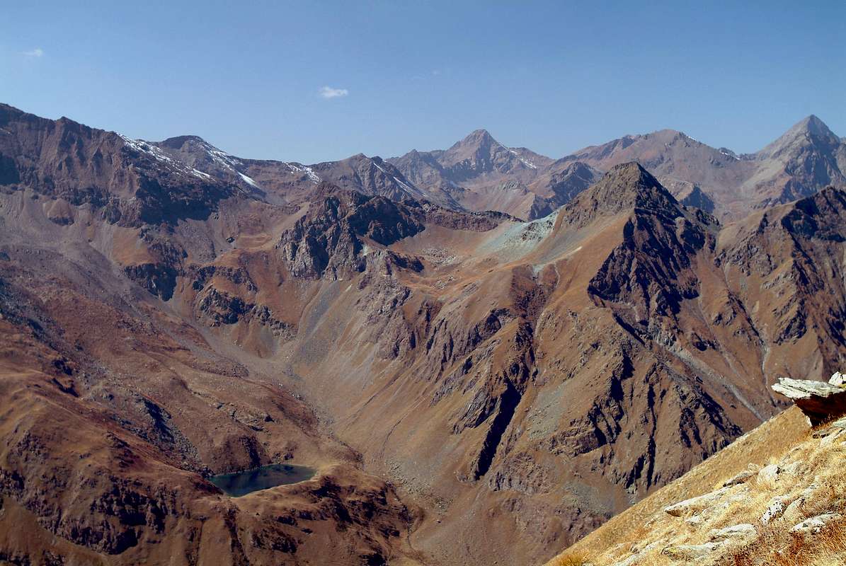 |
I am the Devil, and this is my Big Ridge
"You see me? Not possible, because the greatest Makeup & Hoax of the Devil is make believe that He is Not There ... / Mi scorgete? Impossibil. Il più gran Trucco ed Inganno sta nel far creder ch'Io Non Esisto ...",
by emilius
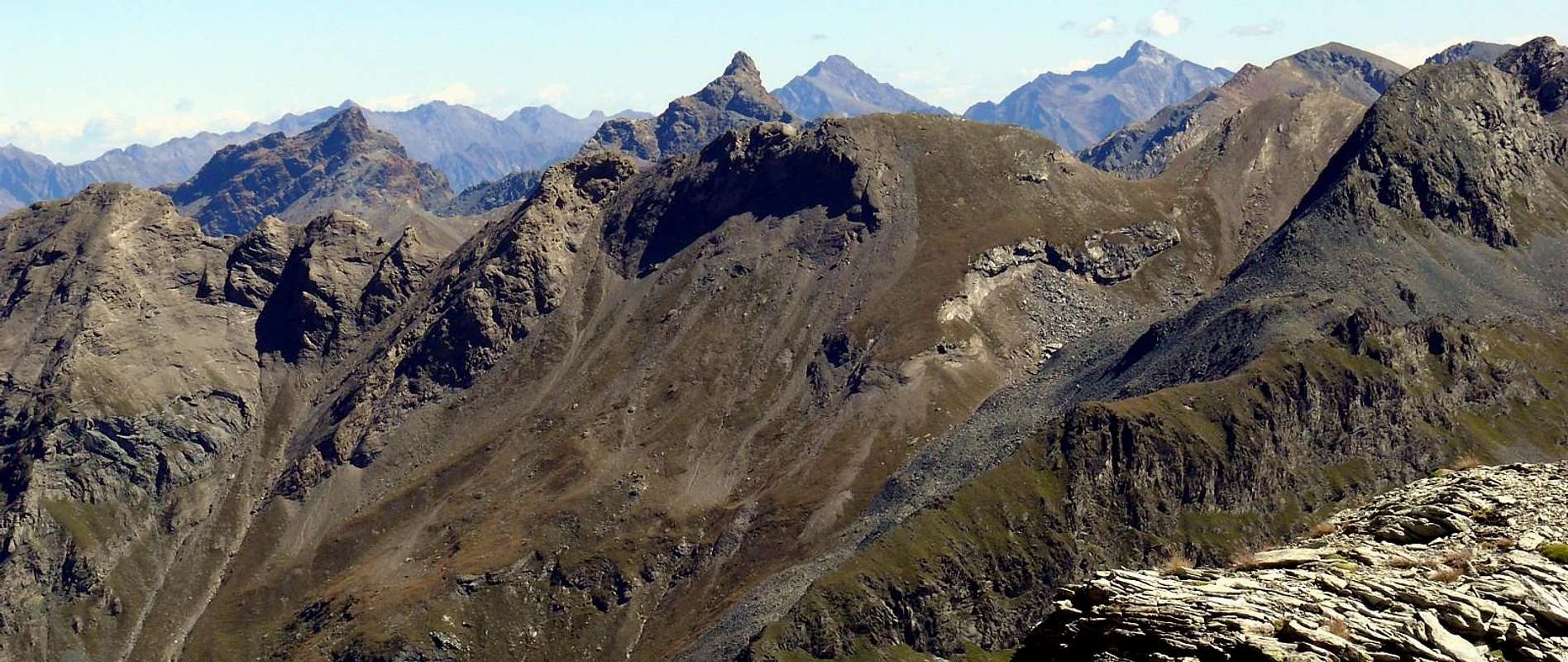 |
"This is My Cresta, Crest of Diavolo. You dominated by the Tersiva, but come on then I'll understand! ...",
by Antonio
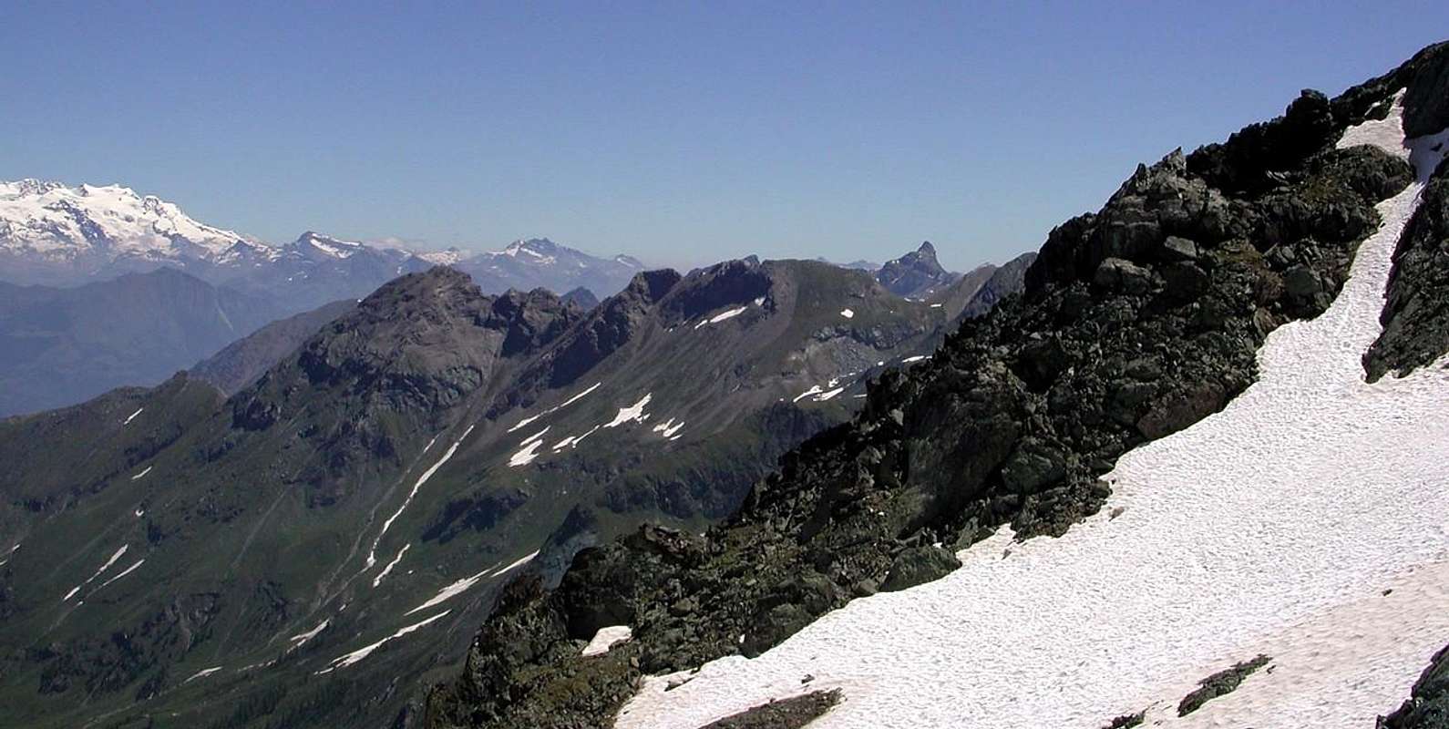 |
The Great Cresta I do not I ever climb. But if they did it in a few uphill. Perhaps no one. Even my friend Osvaldo Pianfetti, called "Yogi", which in this walloon for many years has been the job of Gamekeeper. Someone also called the Devil's Ridge. and there is a reason. Its spiers are rugged and steep, and if you see them through the storm appears to be the Anti Chamber of Hell. So if someone tries to go to this place: "101. Grande Cresta 2908 m IGM .... follow the easy ridge at the end of debris and grass up to 2941 meters altitude IGM. Summit or climb over the rocks around them to the left and go towards keeping N in preference to the left of the ridge, pass me the share in 2904 to reach the top ... ". So in "Emilius Rosa dei Banchi Park M.Avic", by Lino Fornelli, pages 174/5, March 2005. But why 2908 meters, if we come to 2941 meters? Mystery, And after that? That stretch of the Ridge South Summit reaches the collar with the Point Plan Rué? Mystery within the Mystery ... I said Lino that someone had tried to climb it, but then, for the bad quality of the rock, he had given up. Even more Mystery within the Mystery. A i believe no one has gone beyond. Why, because, gentlemen, this is the Ridge of the Devil and he lives here. knows even babies, so that just below the Village of Les Druges there "Locanda del Diavolo". More than this !
The Cresta del Diavolo
"No one can judge me! I stretch my spine towards the Valley and swallow ...",
by Antonio
The Cresta del Diavolo
"No one can judge me! I stretch my spine towards the Valley and swallow ...",
by Antonio
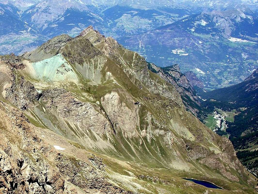 |
La Grande Cresta io non l'ho mai salita. Ma se l'hanno salita l'han fatto in pochi. Forse nessuno. Neppure il mio amico Osvaldo Pianfetti, detto "Yogi", che in questa valle per tanti anni ha svolto il mestiere di Guardiacaccia. Qualcuno la chiama anche Cresta del Diavolo. E ce n'é un motivo. Le sue Guglie son aspre e dirupate e se le vedete sotto il temporale appaion come l'Anti Camera dell'Inferno. Così se qualcun prova ad andare in questo posto: " 101. Grande Cresta 2908 m IGM.... seguire la facile cresta di fine detrito ed erba sino alla quota 2941 m IGM. scavalcare le rocce sommitali od aggirarle a sinistra continuando verso N tenendosi di preferenza a sinistra del filo di cresta, superare la quota 2904 m e raggiungere la vetta ... ". Così in "Emilius Rosa dei Banchi Parco del M.Avic", da parte di Lino Fornelli, pagine 174/5, Marzo 2005. Ma perché 2908 metri, se poi arrivano a 2941 metri? Mistero, E dopo? Quel tratto di cresta che dalla Sommità Sud raggiunge il colletto con la Punta di Plan Rué. Mistero nel Mistero ... Mi disse Lino che qualcuno aveva provato a percorrerlo, ma poi, per la cattiva qualità della roccia, aveva rinunciato. Ancor di più Mistero dentr'il Mistero. A mio avviso nessuno é andato oltre. Perché? Perché, Signori, questa é la Cresta del Diavolo e lui qui abita. Lo sanno anche i neonati, tanto ne é che appena al di sotto del Villaggio di Les Druges esiste la "Locanda del Diavolo". Più di cosi
The Cresta del Diavolo
"Go ahead to Tersiva, so will increase the trace of Mass. Here are intent the Illuminateds! ...",
by Antonio
"Si possono fare due partite di Calcio contemporanea, leggere un Giallo o pascolare tranquillamente da 400 a 500 Vacche / You can do two games of Football contemporary, read a Thriller or graze quietly from 400 to 500 Cows",
by emilius
The Cresta del Diavolo
"Go ahead to Tersiva, so will increase the trace of Mass. Here are intent the Illuminateds! ...",
by Antonio
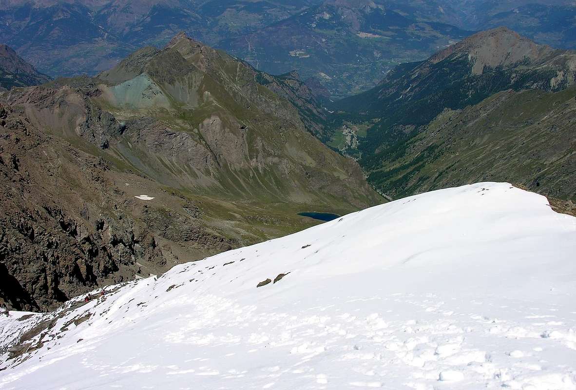 |
"The Sleeping into Wood Beauty": the Corquet or Courquet?
Il Mont Courquet, ossia "coricato"/Mount Corquet, or "lying down"by emilius
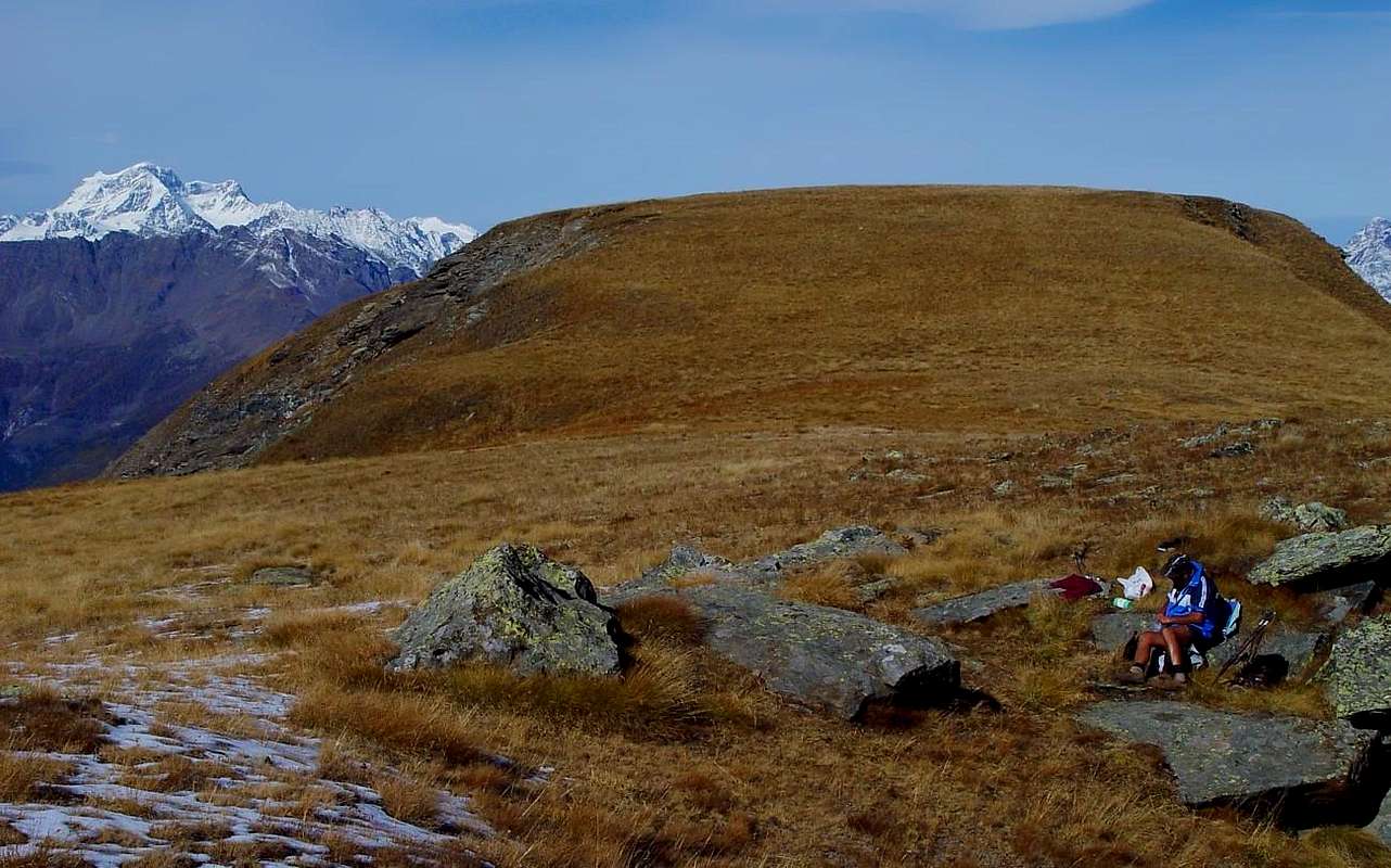 |
Mount Courquet is not the Mont Corquet. As it is not Mount Corquet? Sure Mount Corquet does not exist, but there is Mont Courquet, as they know the towns of Saint Marcel and Fénis, places at his feet. For them, the Mount Courquet is the Monte Lying , ie lying down, as if asleep. And they are absolutely right! Then the cartographers can mangle all the names of the Earth, but he remains the Mont Courquet. So even call him Giovanni and Luigi Bobba Vaccarone that they were Erudites on the subject, in their "Guide of the Western Alps", 1896, on page 114: "Mont Courquet m. 2529. Upon request, the buttress of Montroux, but more south, is accessible from almost every side" and then also Montroux and not Mount Roux, for his appendix to the North-northwest. So, rightly, reproduce Giulio Berutto and Lino Fornelli, 109 years later, in Guidebook "Emilius Rosa of Banchi Park M.Avic", 2005, on page 175: "103 . Mount Courquet 2530m IGM . Great dome and a flat peak that overlooking the beautiful valley of Les Druges. Good vantage point ... ". This was precisely the Courquet, or the Mount Lying. Nor can one use a French word, since in this language the word is translated as coucher lie down, lie down and étendre is if coucher, s'aliter, see the coucher du soleil and, finally, the lying is just coucher. No, there is no justification whatsoever. A nice dilemma . What to do? Simple: eliminate all cards Geographical and belittling. Double Dilemma, because doing so would come into play Politics and Diplomacy. But see if this little Courquet had to create all the fuss! But he has reason to sell. Imagine if you will if they call me Cordellina, or Cerdellina , or Cirdellina also Curdellina and again, only a different voice and everything changes, nothing to do, my name is Cardellina, which is the female goldfinch, a beautiful little bird good at singing. Once this was widely: the surnames came from a nickname. Mr. Moulin owned a Mill, Mr. Bois had at least one Wood, Mr. Conti had allegedly had an ancestor Count etc. and to infinity. Even the villages and hamlets of the mountains in Aosta Valley: Ronc in Saint Marcel was the Family Ronc, Moulin de l' Or or the Water Mill in Champorcher Valley, the old shelter Pouleins to Arbolle small Foals, as it is still in ' emblem on the front seat of the Municipality of Pollein, ChezlesMerloz ie at the Family Merloz, Frassiney or near a forest of Ash trees and so on ad infinitum. Even the Romans, more practical, Quart was to Quartum Milium from Augusta Praetoria Salassorum, Nus in Nine Miles and Cogne Conium, where he drew his Loadmine and the coins were minted Empire. Fénis? do not know , but those are all details. So I think that my Grandfather Francesco had to be a good singer. He sang like a Goldfinch, that he too is called in this name since it is voracious eater Cardoons. In such a case, I think, otherwise the derivation of my last name you should ask it to my Grandfather Francesco, who had 16 children, half males and half females do no wrong to anyone. Anticipated a Century to the Times. Some doubt the truth, and I still, however , my name is Cardellina, at most Cardellàina , but this is a Translation into American. It can be accepted. Fashion is ...
For such reason, the Courquet not really want to know to become Mr. Corquet.
Indeed, the Courquet resented this lack of respect. From big and nice Great Cat, asleep with her head turned to the North to resting on the left leg, bent in the direction of Montroux and the left stretched toward the Saint Julien, became a Wild Cat and Bad. Expected to wait for the Winter all the way through. When the snow fell, which covered it with their white mantle as an Ermine, became even worse: a Lynx. He knew that the other parties could not move and was waiting for them in the North, with its steep ridges and road filled with powdery snow and dangerous. Beware Ladies and Gentlemen Ski Mountaineers who wander with Snowshoes, the Friend is dangerous and has already made a Victim. Then, as we age, it has become even more evil and 2000, Year of the Great Flood, was thrown from a landslide Crest North-northwest facing slopes to the North, where You spend Vol Do not fall into the trap of looking only in Summer, when on his large and spacious Summit, which descends towards the South on Crotey Pass, can be carried out simultaneously two games of Football, Thriller or read quietly graze a herd of 400 to 500 Cows ...
"But if they get the Snows Music changes and the Ascent and the Quick Glances / Ma se cadon le Nevi la Musica cambia e con lei la Salita ed i Colpi d'Occhio",
by emilius
For such reason, the Courquet not really want to know to become Mr. Corquet.
Indeed, the Courquet resented this lack of respect. From big and nice Great Cat, asleep with her head turned to the North to resting on the left leg, bent in the direction of Montroux and the left stretched toward the Saint Julien, became a Wild Cat and Bad. Expected to wait for the Winter all the way through. When the snow fell, which covered it with their white mantle as an Ermine, became even worse: a Lynx. He knew that the other parties could not move and was waiting for them in the North, with its steep ridges and road filled with powdery snow and dangerous. Beware Ladies and Gentlemen Ski Mountaineers who wander with Snowshoes, the Friend is dangerous and has already made a Victim. Then, as we age, it has become even more evil and 2000, Year of the Great Flood, was thrown from a landslide Crest North-northwest facing slopes to the North, where You spend Vol Do not fall into the trap of looking only in Summer, when on his large and spacious Summit, which descends towards the South on Crotey Pass, can be carried out simultaneously two games of Football, Thriller or read quietly graze a herd of 400 to 500 Cows ...
by emilius
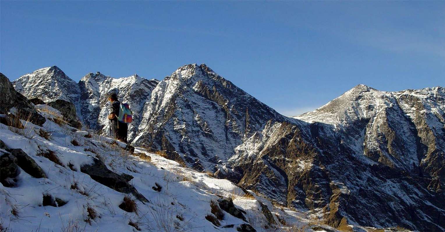 |
Il Mont Corquet non'é il Mont Corquet. Come non'é il Mont Corquet? Certo il Mont Corquet non esiste, ma abbiamo il Mont Courquet, come lo conoscon i centri abitati di Saint Marcel e Fénis, posti ai suoi piedi. Per lor il Mont Courquet é il Monte Coricato, cioé sdraiato, quasi che dorme. Ed han pienamente ragione! Poi i cartografi posson storpiar tutti i nomi della Terra, ma lui rimane il Mont Courquet. Così lo chiamano anche Giovanni Bobba e Luigi Vaccarone, ch'eran dei Dotti in materia, nella loro "Guida delle Alpi Occidentali", 1896, alla pagina 114: "Mont Courquet m. 2529. Trovasi sullo stesso contrafforte del Montroux, ma più a sud; é accessibile pressoché da ogni banda"; e quindi anche Montroux e non Mont Roux, per la sua appendice di Nord-nordovest. Così, giustamente, riprendon Giulio Berutto e Lino Fornelli, 109 anni appresso, in Guida "Emilius Rosa dei Banchi Parco del M.Avic", 2005, alla pagina 175: "103. Monte Courquet 2530 m IGM. Grosso cupolone dalla sommità pianeggiante che domina la bella conca di Les Druges. Buon punto panoramico ... ". Trattasi proprio del Courquet, ovvero del Monte Adagiato. Neppur si può ricorrer a Francesismo, poiché in questa lingua il verbo coricare si traduce con coucher, étendre e coricarsi é se coucher, s'aliter, vedi le coucher du soleil ed, infine, il coricamento risulta proprio coucher. Niente, non esiste Giustificazione alcuna. Un bel Dilemma. Cosa fare? Semplice: eliminare tutte le carte Geografiche e rifarle. Doppio Dilemma, perché così facendo entrano in gioco la Politica e la Diplomazia. Ma guarda se sto piccolo Courquet doveva crear tutto sto trambusto! Ma lui ha Ragion da vendere. Immaginate se a voi vi chiamassero Cordellina, o Cerdellina, o Cirdellina oppure ed ancora Curdellina, solo una vocale diversa e tutto cambia; niente da fare mi chiamo Cardellina, ch'é la femmina del Cardellino, un bel uccellino bravo a cantar. Una volta così s'usava: i cognomi provenivano dal sovrannome. Il Signor Moulin era proprietario d'un Mulino, il Signor Bois aveva almen'un Bosco, il Signor Conti si vantava d'un antenato Conte ecc. ed all'infinito. Anche i Villaggi e le Frazioni di montagna in Valle di Aosta: Ronc a Saint Marcel era della Famiglia Ronc, Moulin de l'Or o Mulino delle Acque a Champorcher, il vecchio Ricovero Pouleins ad Arbolle da Puledrini, com'é ancor oggidì nell'emblema posto sul frontespizio del Comune di Pollein, ChezlesMerloz ossia presso la Famiglia Merloz, Frassiney ovvero vicino ad un Frassineto e così all'infinito. Anche pei Romani, ancor più pratici, Quart era ad Quartum Milium ab Augusta Praetoria Salassorum, Nus a Nove Miglia e Cogne da Conium, dove s'estraeva la Magnetite e si coniavan le Monete dell'Impero. Fénis? non si sa, ma quelli son tutti particolar. Così'o penso ch'un mio avo doveva esser un buon cantante. Cantava come un Cardellino, che pure lui si chiama in codesto nome poiché é vorace mangiatore di Cardi. In questa maniera penso, altrimenti la derivazione del mio cognome si dovrebbe chiederla a mio Nonno Francesco che aveva avuto 16 figli, metà maschi e metà femmine per non fare torto a nessuno. Anticipava d'un Secolo i Tempi. Qualche dubbio per la verità, mi riman e, comunque, mi chiamo Cardellina, al massimo Cardellàina, ma questa é una Translation in American. Può esser accettata. Fa Moda ...
Per siffatto motivo, il Courquet non ne vuole proprio saper di diventar il Signor Corquet.
Anzi, il Courquet si offese per questa mancanza di rispetto. Da grande e simpatico Gattone, addormentato con la testa rivolta a Settentrione ad appoggiata sulla zampa sinistra, piegata in direzione del Montroux e la sinistra allungata verso il Saint Julien, diventò un Gatto Selvatico e Cattivo. Attendeva l'Inverno per attendere tutt'al varco. Quando cadevan le nevi, che lo coprivano con il lor bianco Mantello come un Ermellino, diventava ancor peggio: una Lince. Sapeva che dalle altri parti non potevan passar e li aspettava a Nord, con i suoi pendii colmi e stra colmi di neve farinosa e pericolosa. Attenti Signori Sci Alpinisti e Signori che gironzolate con le Racchette da Neve, l'Amico é pericoloso ed ha già fatto una Vittima. Poi, invecchiando, é diventato ancora più Maligno e nel 2000, Anno della Grande Alluvione, ha scaraventato una frana dalla Cresta Nord-nordovest verso i pendii a Nord, ove passate Voi. Non cadete nel tranello di guardarlo soltanto in Estate, quando sulla sua larga e spaziosa Sommità, discendente verso Sud al Col Crotey, si possono effettuare in contemporanea due partite di Calcio, leggere tranquillamente un Giallo o pascolare una mandria da 400 a 500 Mucche ...
"But when the Snow covers it with his invisibility cloak, looks with a Sly Eye on the Tersiva and with each other, Bad & Malignant, to Valley / " Ma quando la Neve lo ricopre col suo Mantello, con un Occhio Sornione guarda la Tersiva e con l'altro, Cattivo & Maligno, giù per la Valle ... ",
by maria grazia s
START & END
Per siffatto motivo, il Courquet non ne vuole proprio saper di diventar il Signor Corquet.
Anzi, il Courquet si offese per questa mancanza di rispetto. Da grande e simpatico Gattone, addormentato con la testa rivolta a Settentrione ad appoggiata sulla zampa sinistra, piegata in direzione del Montroux e la sinistra allungata verso il Saint Julien, diventò un Gatto Selvatico e Cattivo. Attendeva l'Inverno per attendere tutt'al varco. Quando cadevan le nevi, che lo coprivano con il lor bianco Mantello come un Ermellino, diventava ancor peggio: una Lince. Sapeva che dalle altri parti non potevan passar e li aspettava a Nord, con i suoi pendii colmi e stra colmi di neve farinosa e pericolosa. Attenti Signori Sci Alpinisti e Signori che gironzolate con le Racchette da Neve, l'Amico é pericoloso ed ha già fatto una Vittima. Poi, invecchiando, é diventato ancora più Maligno e nel 2000, Anno della Grande Alluvione, ha scaraventato una frana dalla Cresta Nord-nordovest verso i pendii a Nord, ove passate Voi. Non cadete nel tranello di guardarlo soltanto in Estate, quando sulla sua larga e spaziosa Sommità, discendente verso Sud al Col Crotey, si possono effettuare in contemporanea due partite di Calcio, leggere tranquillamente un Giallo o pascolare una mandria da 400 a 500 Mucche ...
by maria grazia s
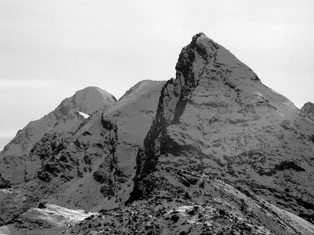 |
The END of First Part
It closes this First Part of Graian of Southeast and we do it with a nice zooming to regress back to the Hill of Arietta ideally, where we had started. But the Second Part will not take its start from this point, But from the Pontonnet Hill (2897m), between the Towers of Pontonnet and Ponton. In fact, the dividing ridge from the Arietta Hill, proceeding first towards the East to the Cima Peradzà, form the Point of the Nouva and a ridge called the pseudo straight Black Rocks of Peradzà, the Top Peradzà and a wide Saddle 2946 meters, an important node topographic and after and this the ridge splits:
a)-: one branch continues Eastward in the direction of Rosa of Banchi and Graian, more specifically, of Southeast.
b)- Another turns North and forms the Bec Costazza and the Tower of Ponton, before of Pontonnet Hill.
As we said from the latter and from the trio Tower of Moussaillon also Moutsaillon, Mount Delà and Mount Glacier, the highest in this area which constitutes the Graian East, will begin the Second Part of Curtain XI°.
"This first part starts from the Hill dell'Arietta and returns to the same, then the ridges run towards East ...",
by Antonio
a)-: one branch continues Eastward in the direction of Rosa of Banchi and Graian, more specifically, of Southeast.
b)- Another turns North and forms the Bec Costazza and the Tower of Ponton, before of Pontonnet Hill.
As we said from the latter and from the trio Tower of Moussaillon also Moutsaillon, Mount Delà and Mount Glacier, the highest in this area which constitutes the Graian East, will begin the Second Part of Curtain XI°.
by Antonio
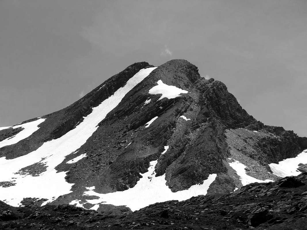 |
Si chiude questa Prima Parte delle Alpi Graie di Sudest e lo facciamo con una simpatica zoommata a regresso tornando idealmente al Colle dell'Arietta, ove avevamo iniziato. Ma la seconda parte non prenderà il suo avvio da questo punto, bensì dal Colle Pontonnet (2897 m), tra la Tour Pontonnet e la Torre Ponton. In realtà la cresta spartiacque dal Colle dell'Arietta, procedendo dapprima verso Est fino alla Punta di Peradzà, forma la Punta della Nouva ed una cresta pseudo rettilinea detta delle Rocce Nere di Peradzà, la Cima di Peradzà ed una larga Sella 2946 metri, importante nodo topografico; dopo e da questa la cresta si sdoppia:
a)-: un ramo prosegue verso Est in direzione della Rosa dei Banchi e delle Alpi Graie, più specificatamente, di Sudest.
b)-: Un altro volge al Nord andando a formare il Bec Costazza e la Torre Ponton, prima del Colle Pontonnet.
Come dicevasi da questo ultimo e verso il trio Torre di Moussaillon o Moutsaillon, Mont Delà e Mont Glacier, il più elevato in questo settore che costituisce le Alpi Graie Orientali, inizierà la Seconda Parte di Curtain XI°.
"But it is the Tersiva that begins the Second Part ...",
by Antonio
a)-: un ramo prosegue verso Est in direzione della Rosa dei Banchi e delle Alpi Graie, più specificatamente, di Sudest.
b)-: Un altro volge al Nord andando a formare il Bec Costazza e la Torre Ponton, prima del Colle Pontonnet.
Come dicevasi da questo ultimo e verso il trio Torre di Moussaillon o Moutsaillon, Mont Delà e Mont Glacier, il più elevato in questo settore che costituisce le Alpi Graie Orientali, inizierà la Seconda Parte di Curtain XI°.
by Antonio
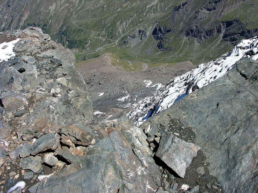 |