Curtain VII° Emilius (Ridges & Walls) First Part

Curtain VII° Emilius (Ridges & Walls) First Part

Page Type Page Type: Fact Sheet
Additional Information County: Aosta

ABOVE the OVERVIEW

This work, always within our Curtains, is divided into three stages: 1)-: crests and walls on the Monte Emilius and the "satellite" Becca di Nona in CURTAIN VII°, which will in turn be divided into a first part in a revolt on the first and second part devoted to "Becca"; 2)-: ridges, walls and buttresses of the mountains that make up its surroundings in CURTAIN X°; 3-: analysis and histories of some nearby mountains but owned by other Groups or Subgroups (Punta Tersiva, Peaks to the North of Arietta's Pass, Mount Glacier, Mount Avic and Rosa of Banchi) Area all of Graian Alps of the Southeast CURTAIN XI°. In addition, this last will be divided into the First, Second, and Third Part, since it covers a very large area of mountains that border the nearby Piedmont. In this first part, after an introduction immediately below, which applies to all three areas under question, I will explain some climbs and personal relations with no taken from Magazines, Newspapers, Diaries Mountain, written notes or, more simply, with oral information had at the time or today. Let's hope so in the Memory! All the three CURTAIN concluded with a Chapter on some peculiarities, or even special "quirks" that relate to the specific sector; the same are just a "hint" photo, referring to the captions included in the same event represented a deepening. Even here the hand of man has left his mark by "changing face", if not in Nature, in Religious signals are widespread in the mountains of Aosta Valley, or, more semply, in route indications and mounds on the road and on the Summits. The messages that you encounter with black lettering inside circular yellow panels (local trails) or rectangular (tracks that combine multiple valleys, or High Routes in the Valley of Aosta in triangular panel) are the result work of five Experts recruited by the Autonomous Region of Aosta Valley in the year 1987, I have personally taken care of this area by the Communes of Aymavilles to that of Pont Saint Martin, Eastern entrance of this Region, or the entire Southern part of the River Dora Baltea and the Champorcher Valley. In the same directions of travel time have been arbitrarily and voluntarily "spread", since the proposals offered trips to the ground, then with very uneven attendance in technical skills and in the degree of training.
^ EMILIUS & "BECCA" North Walls and the two North-northeast great Edges, by emilius.
Questo lavoro, sempre all'interno dei nostri Sipari, si divide in tre momenti: 1)-: creste e pareti concernenti il Monte Emilius ed il "satellite" Becca di Nona in CURTAIN VII°, a sua volta suddiviso in due Parti delle quali la Prima é perlappunto dedicata all'Emilius; 2)-: creste, pareti e contrafforti delle montagne che costituiscono il suo circondario in CURTAIN X°; 3-: analisi e storie di alcune montagne vicine ma appartenti ad altri Gruppi o Sottogruppi (Punta Tersiva, Cime a Nord del Colle dell'Arietta, Mont Glacier, Monte Avic e Rosa dei Banchi) tutti nell'Area delle Alpi Graie del Sudest in CURTAIN XI°. Inoltre questo ultimo sarà diviso in Prima, Seconda e Terza Parte, poiché ricopre un'area molto vasta di montagne confinanti con la vicina Regione Piemonte. In questa prima parte, dopo una premessa subito qui in basso, tale da valere per tutte e tre le aree prese in questione, verran illustrate alcune salite personali e no con relazioni tratte da Riviste, Giornali, Diari di Montagna, appunti scritti o, più semplicemente, con informazioni orali avute a suo tempo oppure ai giorni nostri. Speriam ben nella Memoria! Tutti i tre CURTAIN sono conclusi con un Capitolo concernente alcune peculiarità, particolarità od anche "stranezze", che riguardano il settore specifico; le medesime sono un semplice "accenno" fotografico, rinviando alle didascalie inserite nelle medesime un approfondimento all'evento rappresentato. Anche qui la mano dell'uomo ha lasciato il suo segno facendo "cambiar volto", se non nella Natura, nei segnali religiosi, molto diffusi sulle montagne della Valle d'Aosta, o, più semplicemente, nelle indicazioni di percorso e nei tumuli lungo la via e sulle Sommità. Le segnalazioni che s'incontran con scritte in nero all'interno di pannelli gialli circolari (sentieri locali) o rettangolari (tracciati che uniscono più valli, oppure Alte Vie della Valle d'Aosta in pannello triangolare) son frutto del lavoro cinque Esperti reclutati dalla Regione Autonoma della Valle di Aosta nell'anno 1987; personalmente ho curato questa zona dal Comune di Aymavilles a quello di Pont Saint Martin, all'ingresso Orientale di questa Regione, ovvero tutta la parte a Meridione del Fiume Dora Baltea, nonché la Valle di Champorcher. Nei medesimi le indicazioni del tempo di percorrenza son state arbitrariamente e volontariamente "allargate", essendo le gite proposte offerte alla massa, quindi con frequentazione molto disomogenea nelle capacità tecniche e nel grado di allenamento.
The Group of Mount Emilius from Western View, by emilius

Accounts, Informations and Advices for Hiking & Mountaineering-Climbing

We indicate by means of a small schematic preamble, the ones that are the most famous or known Emilius or ridges and walls of the surrounding mountains, we will consider the most challenging climbs and the most popular. We will analyze only the area around this mountain part, in a narrower sense, the same, or on the Central Valley of Dora Baltea Stream, near the City of Aosta in the stretch between the Towns of Aymavilles to the West and to the East of Saint Marcel with the above Pila Basin and in succession, always from West to East, the Vallons of Dard/Comboé/Arbole, of the Arpisson, Laures and Saint Marcel. In the Southwestern boundary of the zone is bounded by the Grand Torrent Eyvia that descends from the Valley of Cogne, in which the interesting part to us is facing north with another valley, this Arpisson said, and the much larger and extended in the Vallon of the Grauson, this will only discuss the ramification of the left (West) or Lussert, and will exclude all but the opposite or Doreire that dates back to Punta Tersiva (3515m). In fact, the extreme limit we have taken into account is the Hill of Saint Marcel or Col Corona('s), located in the extreme South of the valley, which is, strictly speaking, the Eastern border of this group of mountains. For convenience, we will divide the Group of Emilius by Subgroups of the three Roèses (3357m) to the East, from the Tower of Salé and Becca as Col Saint Marcel. the Subgroup of the Point Garin (3461m) to the South, from the Hill of Arolle to the Arpisson Point. and Point of the Valletta (3090m) to the West-southwest, from the Col Garin to Punta de la Pierre. Section by section, we will give you concise information on the history and composition of these faces and ridges, starting from the Maximum Peak and other mountains to the major highlight; also some details and notes, as well as techniques on the various ways forward. From the most famous and well known to those less important, but perhaps more interesting and fun, or simply view. The overall difficulty are listed with the traditional Scale U.I.A.A. and with the progressive acronyms F, PD, AD, D, MD and ED, ranging from easy to extremely difficult, as regards the steps are evaluated by the I° to VI°. In both cases may be accompanied by signs - or +, depending on whether you wish to signal a decrease or an increase of the same difficulties. The slopes or ice couloirs or goulottes, just for the truth, are stated in degrees of slope (= °). To note, in each case, which are the preferred paths in ridge rather than not on the walls, even on those, in monolithic appearance, as the Black Triangle of Emilius; actually the quality of the rock, everywhere, leaves much to desired, being almost always broken and presenting objective dangers for the existing suspended material. The climbing is safe only in short stretches, where it is more compact, but that can be counted on the fingers, even the paths on the ridge require caution at all times to the same considerations. We are far from protogine of Mont Blanc or the Gran Paradiso granite! These considerations also apply to other groups of neighboring Tersiva's Point, Mount Glacier, Mount Avic, there farthest from Champorcher Valley on the border with Piedmont, Rosa of the Banchi. There have been attempts to enrich this exhibition with anecdotes, stories personalized or personal memories of friends or acquaintances, guides or other climbers or just for the one that says little and sparse literature, incidentally as for all minority groups. Hoping to please ...
^ ^ "Edges", by Osw
Possiamo indicare, tramite un piccolo preambolo schematico, quelle che sono le più famose o conosciute creste e pareti dell'Emilius (3559m) o delle montagne circostanti; prenderemo in considerazione le ascensioni più impegnative e le maggiormente frequentate. Analizzeremo solo quell'area intorno a questa montagna facente parte, in senso più ristretto, della medesima; ovvero concernente la Valle Centrale della Dora Baltea, presso la Città di Aosta nel tratto compreso tra i Comuni di Aymavilles ad Occidente e di Saint Marcel ad Oriente con la soprastante Conca di Pila ed in successione, sempre da Ovest ad Est, i Valloni del Dard/Comboé/Arbole, dell'Arpisson, delle Laures e di Saint Marcel. A Sudovest il confine della zona é delimitato dal Torrent Grand Eyvia discendente dalla Valle di Cogne, nella quale la parte a noi interessante é rivolta a Settentrione con un altro vallone, anche questo detto di Arpisson, ed il ben più vasto ed esteso Vallone del Grauson; di questo tratteremo solo nella ramificazione di sinistra (Ovest) o di Lussert, mentre escluderemo quasi del tutto l'opposta o di Doreire risalente insino alla Punta Tersiva (3515 m). Infatti il limite estremo da noi preso in considerazione risulta esser il Colle di Saint Marcel o di Corona(s), sito nella parte estrema e Meridionale dell'omonima valle, che costituisce, in senso stretto, il confine Est di questo gruppo di montagne. Per comodità, divideremo il Gruppo dell'Emilius dai Sottogruppi delle tre Roèses (3357 m) ad Est, dalla Torre di Salè e Becca al Colle di Saint Marcel. della Punta Garin (3461 m) a Sud, dal Colle di Arolle alla Punta di Arpisson. e della Punta della Valletta (3090 m) ad Ovest-sudovest, dal Col Garin alla Punta de la Pierre. Sezione per sezione, vi doneremo concise informazioni sulla storia e sulla composizione di queste pareti e creste, partendo dalla Vetta Massima e fino alle altre montagne notevoli di evidenziazione; inoltre alcuni ragguagli e note informative, nonché tecniche, sulle varie vie da percorrersi. Da quelle più rinomate e conosciute a quelle meno importanti ma, forse, più interessanti e divertenti o, semplicemente, panoramiche. Le difficoltà complessivente sono elencate con la tradizionale Scala U.I.A.A. e e con la progressiva siglatura di F, PD, AD, D, MD ed ED, che vanno dal Facile all'Estremamente Difficile; per quanto concerne i passaggi vengono valutati dal I° al VI°. In entrambi i casi possono essere assecondati dai segni - oppure +, a seconda dal fatto che si voglia segnalare una diminuzione od un aumento delle difficoltà medesime. I pendii glaciali o le goulottes o couloirs, pochi per la verità, vengono valutati in gradi di pendenza (= °). Da annotarsi, in ogni caso, che sono da privilegiare i percorsi in cresta piuttosto che non sulle pareti, anche su quelle, in apparenza monolitiche, come il Triangolo Nero dell'Emilius; in realtà la qualità della roccia, ovunque, lascia alquanto a desiderare, essendo quasi sempre rotta e presentando pericoli oggettivi per il materiale sospeso esistente. L'arrampicata rimane sicura soltanto in brevi tratti, ove é più compatta, ma che si contano sulle dita delle mani; anche i percorsi in cresta richiedono sempre prudenza per le medesime considerazioni. Siamo ben lontani dal protogino del Monte Bianco o dal granito del Gran Paradiso! Queste considerazioni valgono anche per gli altri gruppi viciniori della Tersiva, del Mont Glacier, del Monte Avic e, laggiù più lontana in Valle di Champorcher ai confini con il Piemonte, della Rosa dei Banchi. Si é cercato di arricchire questa esposizione con aneddoti, racconti personalizzati o ricordi personali, di amici o conoscenti, guide oppure altri alpinisti o, semplicemente, per quello che riporta una scarsa e scarna letteratura, daltronde come per tutti i gruppi minori. Sperando di far cosa gradita ...
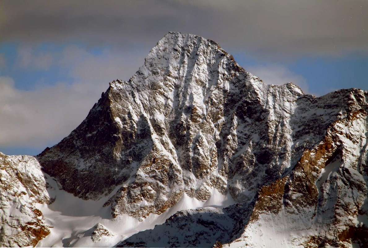
The Group of Mount Emilius from Salé Tower (left) to Vallaisan Pass and, in distance, Tersiva Point, by Antonio

West-northwest Ridge or The "CHAINED" Emilius

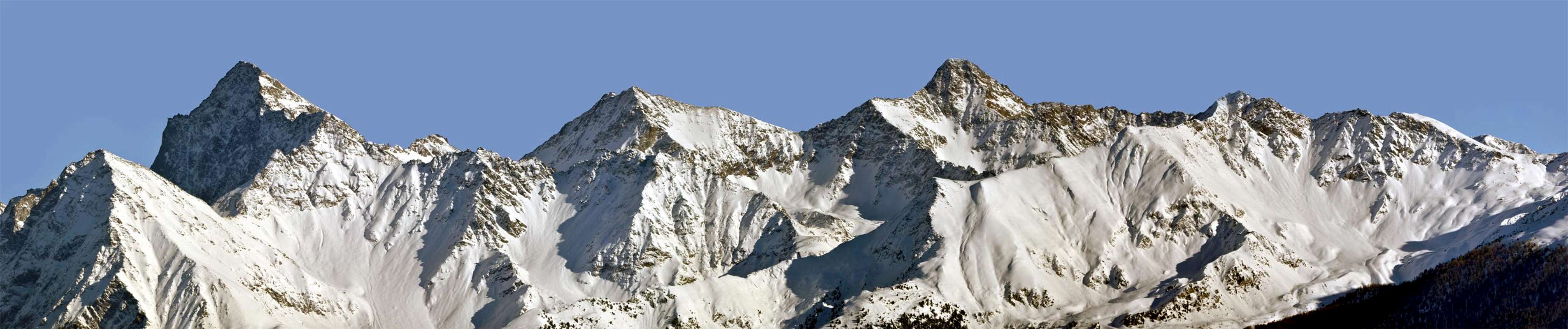
^ ^ ^ From a "natural & uncontaminated" EMILIUS to Great Paradise Mountain Chain or Southwestern View, by marco87.
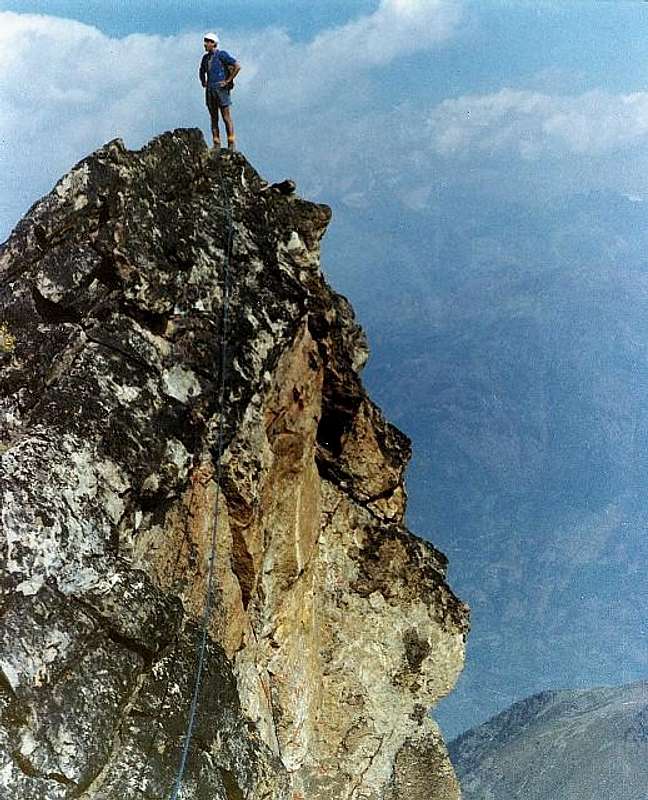
The history of this beautiful and long ridge that links the Monte Emilius to her younger sister Becca of Nona, almost an arm on the shoulder of the other, has a twofold face with diametrically opposed aspects. On one side of a ridge of classic and not so difficult nor easy path and see that since 1902, the year of its first ascent in 2004, the year of the opening of the Via Ferrata on the same, just pass a dozen groups rope climbers. The Jag 3150 meters (3050 feet and not as I.G.M. reported in its Charter to 1:25.000) or the Red Tower was a passage not easy and not such as to require a bypass to the North with an exposed passage in descent of about 25 meters, this and the three small, square red towers, followed by a gray vertical jump, in the end, slammed the initiative and it was not this way for everyone. How to show the steps in more than a Century. The first to arrive on the same are the two climbers Giovan Battista Devalle and Ercole Daniele accompanied by Mountain Guides Valtournanche Alexander Pession Luiugi Bich. The previous day, August 29th, 1897, had made the first ascent of the Becca of Seneva (3086m) through the steep Western Wall facing to the Arpisson. The next day looking for the first ascent of the North Face of Emilius, who had already unsuccessfully attempted September 18th, 1878 by Martino Baretti and Luigi Bruno with the Guides of the Susa Valley Augusto and Vittorio Sibille, who had to give up not far from the Top rejected by the "verglass" with a path not easy to find (C.A.I. Bulletin 1878 page 565), even though this a group of rope climbers is rejected from the wall itself and you will have to "settle" to rise much further to the right through the wall of the North Little Emilius (3342 m). The rope will be released on the West Ridge near the same and go up the ridge skirting the most difficult points in the North Wall. It turns out, however, the first via and the "loopholes" are necessary despite the fact that the group is made ​​up of strong climbers (RM 1897, page 385). And even the doodles that accomplish the Abbot Joseph Maria Henry with his mule Guide Charvensod Grégoire Comé when in September 16th, 1902, after exploring downhill slopes and in the opposite Crest East while it is virgin, come down from the rope down to the near the Little Emilius before rebounding with a diagonal across the South Slope (RM 1903 pages 76/78), the next day will complete the exploration reaching the same point with some workarounds, starting from the Hill Carrel between "Becca" and Emilius. Ascent combined with some digression, but in a clean and genuine. A few days later two good climbers, and Emilio Questa with Felice Mondini, unaware that they had been preceded, run directly by the City of Aosta to even bypass them by a few, the first complete ascent (RM 1902, page 434 and 1908 page 308), the crest is made​​, not integrally , but entirely with the criteria of the time.
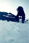
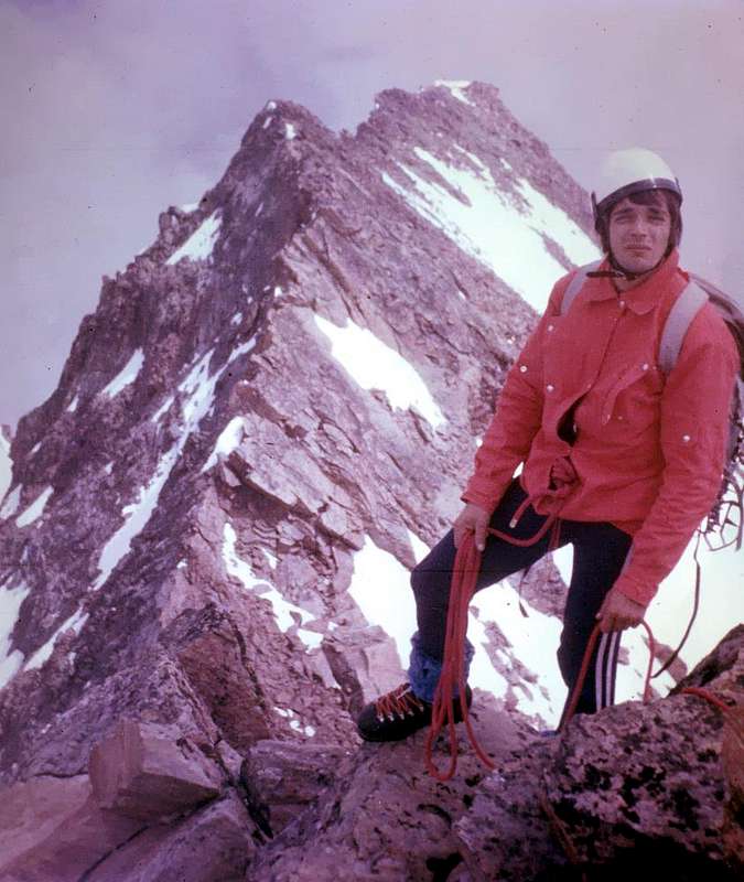
On EMILIUS Old and Original WEST CREST, 1974, 1976, 1977 and 1991, by SalVal, Camillo Roberto Ferronato, & Osw..
EMILIUS s SW Buttress, First Ascent 1974: Descendig from Comboé s TRIDENT
<i>To distrust from those low profile and that they walk to low head ...</i>
Descent of Trident de Comboé after the climb<br> of the entire Monte Emilius s  SW spur
EMILIUS s SOUTHWEST Buttress, First Ascent Absolute and Integral 1974
MONTE EMILIUS SW Spur crossing 1974 with Variant on North Face Right Route 1998
Then the ridge falls by the wayside for many years, because since 1926 the focus has turned to the North Wall, climb completely a year later by Amilcare Crétier and Lino Binel, and to the East, after the disgrace of 1929, will have to wait until 1935 with Giusto Gevasutti and Renato Chabod. We find traces of the same only in the Winter 1940/41 when the brave mountaineer Trieste Nerino Gobbo performs the first solo and the first winter. A nice firm, as well as "wild". In the next Summer we have a brilliant achievement by the Mountain Guide Aosta Giulio Adolfo "Dulo" Ourlaz who with his wife Aurora Wuillerminaz (will be shot by the Nazis) salt N-NE Edge, go down the West Ridge, goes back to the " Becca" which descend through the N-NE "Crestone" on a tour of the Vallon of almost total Arpisson. But after the war intentions are directed to the first repetition, and so we will have to Pietro "Piero" Rosset and Franco Garda in the Summer of 1946 to the East, while the same in February of '49 completed the first winter of the Edge N-NE, across the North Wall. But the real goal becomes the Black Triangle, located at the edge of the latter. After many attempts, even by illustrious names, it will be won in September 1960 by the same Mountain Guide Rosset together to champion and Valpelline Mountain Guide Angel "Angelino" Bozzetti. The remote on the East Giovanni "Agostino" Zulian in September 1961 and the opening of a new route along the Pillar of Right on the North by Renato Quendoz and "Pino" Trevisan in September 1970 closed almost completely at this stage. Now all that remains is to go to "correct" the itineraries of the past. When we go August 1th, 1976, with Camillo, to explore it starting from the Hill Carrel we are faced with the surprise of the Tooth 3150 meters from the Top of Mot Ròss of Comboè we knew of two years ago, because we had taken August 04th the long crossing of the South-southwest Buttress starting from Pila and through the Vallon of Arbolle. Even though we are tired, we had avoided the "Jumping Grey" on the North Wall (worse than ever) on broken rocks and marches, as did the rope in 1897. This time, the tooth fell on the wire, we cross the line until at Summit. A year later, July 11th, we're going to fix what was done in 1974: we go up to the Western Slope of Ròss Pass and again we walk in full. Surely it is a great undertaking that carried out between the Summers amongst 1985 and 87 by Carlo Lucianaz Charvensod that, even starting from his house, making a path similar to that of the roped Ourlaz-Wuillerminaz in July 1941, but uphill and downhill on "Becca" after the ""Crestone" North-northeast of the Becca di Nona, through both East and West of the Glaciers Arpisson, climb on North-northeast Edge and go down the West Ridge to the Carrel Hill, with, finally, return to Charvensod Hamlet. A beautiful Marathon! Worthy of a colt bred. Some partial path, linked to other objectives such as the ascent of the East Face of Mount Ròss is crossing up to the Little Emilius of June 6th, 1999, closed the speech of this old ridge, seen in the original way of travel. I am not aware of many other climbs since then; see the box below. And all this until 2004 when equipped the Via Ferrata; but since then the via can not be considered the same, as distorted by the technical point of view and also naturalistic. Indeed, we are aware of several failures of the rock in pieces equipped, so much so that it was necessary to make the temporary closure.
 Aug 01, 1976: along the Monte Emilius s west<br> ridge; in the foreground  Piccolo Emilius <i>3342m</i>
MOUNT EMILIUS Original West Ridge with Storm 1976
Brooken s SPECTRE on WEST Ridge
MONTE EMILIUS 33 ROUTES HISTORY W-NW Ridge 1976
EMILIUS s INFERNAL & Integral stormy WEST RIDGE 1976
La storia di questa bella e lunga cresta che lega il Monte Emilius alla sorella minore Becca di Nona , quasi un braccio sulla spalla dell'altra, possiede una duplice faccia con aspetti diametralmente opposti. Da una parte una cresta di tipo classico, non così difficile ma neppur di semplice percorso e tal da vedere dal 1902, anno della sua prima salita, al 2004, anno di apertura sulla medesima della Via Ferrata, transitare appena una dozzina di cordate. Il Dente 3150 metri (e non 3050 metri come I.G.M. riporta nella sua Carta al 25.000) o Torre Rossa costituiva un passaggio non facile e tale da richiedere un aggiramento a Nord con un passaggio esposto ed in discesa di circa 25 metri; questo e le tre piccole e squadrate torri rosse, seguito da un salto grigio verticale, nella parte finale, frenavano le iniziative e questa via non era per tutti. Come dimostrano i passaggi in più d'un Secolo. I primi ad arrivare sulla medesima sono i due alpinisti Giovan Battista Devalle ed Ercole Daniele accompagnati dalle Guide di Valtournanche Alessandro Pession e Luigi Bich. Il giorno precedente, 29 Agosto 1897, avevano effettuato la prima ascensione della Becca di Seneva (3086 m) tramite la ripida Parete Ovest che guarda verso l'Arpisson. Il giorno dopo cercano la prima salita della Parete Nord dell'Emilius, che già infruttuosamente era stata tentata il 18 Settembre 1878 da Martino Baretti e Luigi Bruno con le Guide della Valle di Susa Augusto e Vittorio Sibille, i quali dovettero rinunciare a non molto dalla Cima respinti dal "verglass" con un percorso non facile da individuarsi (Bollettino CAI 1878, pag.565); anche questa cordata però viene respinta dalla parete vera e propria e si dovrà "accontentare" di salire molto più a destra tramite la Parete Nord del Piccolo Emilius (3342 m). La cordata uscirà sulla Cresta Ovest nei pressi del medesimo e salirà la cresta aggirando i punti più difficili a Nord sulla parete. Risulta, comunque, il primo percorso e le "scappatoie" son necessarie nonostante che la cordata sia composta da forti alpinisti (RM 1897, pag. 385). Ed anche i ghirigori che compiono l'Abate Joseph Maria Henry con la sua Guida a mulo di Charvensod Grégoire Comé quando il 16 Settembre 1902, dopo aver esplorato in discesa ed in risalita l'opposta Cresta Est pur essa vergine, scendono dalla Cima fino nei pressi del Piccolo Emilius per poi risalire con un diagonale attraverso il Versante Sud (RM 1903, pagine 76/78); il giorno appresso completeranno l'esplorazione raggiungendo il medesimo punto con alcuni aggiramenti partendo dal Colle Carrel tra "Becca" ed Emilius. Salita combinata con qualche divagazione, ma in modo pulito e genuino. Qualche giorno dopo due bravi alpinisti, Emilio Questa e Felice Mondini, ignari d'esser stati preceduti, partono direttamente dalla Città di Aosta per effettuare, anche loro tramite qualche aggiramento, la prima salita completa (RM 1902, pag. 434 e 1908, pag. 308); la cresta é fatta, non integralmente, ma interamente con i criteri dell'epoca. Poi la cresta cade nel dimenticatoio per molti anni, perché dal 1926 l'attenzione é rivolta alla Parete Nord, salita completamente l'anno dopo da Amilcare Crétier e Lino Binel, ed alla Est che, dopo la disgrazia del 1929, dovrà attendere il 1935 con Giusto Gevasutti e Renato Chabod. Ritroviamo tracce della medesima solo nell'Inverno 1940/41 quando il bravo alpinista di Trieste Nerino Gobbo compie la prima solitaria e la prima invernale. Una bella impresa, ed anche "selvaggia". Nella successiva Estate abbiamo una bel exploit da parte della Guida di Aosta Giulio Adolfo "Dulo" Ourlaz che con la moglie Aurora Wuillerminaz (sarà fucilata dai Nazisti) sale lo Spigolo N-NE, scende per la Cresta Ovest, risale alla "Becca", alla quale scenderà tramite il Crestone N-NE in un giro quasi totale del Vallone dell'Arpisson. Però dopo la guerra gli intenti son rivolti alle prime ripetizioni e così avremo quella di Pietro "Piero" Rosset e Franco Garda nell'Estate del 1946 alla Est, mentre gli stessi nel Febbraio del '49 compiono la prima invernale dello Spigolo N-NE, dall'altra parte della Parete Nord. Ma il vero obiettivo diventa il Triangolo Nero, posto al limite di quest'ultimo. Dopo molteplici tentativi, anche da parte di nomi illustri, sarà vinto nel Settembre del 1960 dallo stesso Rosset insieme al fuoriclasse nonché Guida di Valpelline Angelo "Angelino" Bozzetti. La solitaria sulla Est di Giovanni "Agostino" Zulian nel Settembre 1961 e l'apertura d'una via nuova lungo il Pilastro di Destra sulla Nord da parte di Renato Quendoz e "Pino" Trevisan in Settembre 1970 chiudono quasi del tutto questa fase. Ormai non rimane che andare a "correggere" i percorsi del passato.
Direct to MONT ROSS de COMBOE and Integral West Ridge to EMILIUS 1977
Osvaldo Cardellina al Col Ross...
Emilius
EMILIUS 33 ROUTES HISTORY BECCA East Wall
On EMILIUS s Old and Original WEST Ridge at present & since 2000  via  ferrata  also  iron route  (SIC !)
Quando il 1 Agosto 1976 andiamo, con il Camillo, ad esplorarla partendo dal Colle Carrel ci troviamo davanti la bella sorpresa del Dente 3150 metri; la parte superiore dal Mont Ròss de Comboè la conoscevamo di già da due anni, perché il 04 Agosto avevamo compiuto la lunga traversata del Contrafforte Sud-sudovest partendo da Pila e tramite il Vallone di Arbolle. Anche noi però, stanchi, avevamo evitato il "Salto Grigio" a Nord sulla parete (peggio che mai) su rocce rotte e marce, come fece la cordata del 1897. Questa volta, sceso il dente sul filo, la percorriamo integralmente fin'in Cima. L'anno dopo, l'11 Luglio, andiamo a rimediare quanto fatto nel 1974: saliamo al Col Ròss da Ovest e nuovamente la percorriamo integralmente. Sicuramente é una bella impresa quella effettuata tra le Estati del 1985 e 87 da Carlo Lucianaz di Charvensod che, addirittura partendo da casa sua, compie un percorso similare a quello della cordata Ourlaz-Wuillerminaz del Luglio 1941, ma in salita e non in discesa sulla "Becca": dopo il "Crestone" Nord-nordest della Becca di Nona, attraversa i due Ghiacciai Ovest ed Est di Arpisson, sale lo Spigolo Nord-nordest e scende per la Cresta Ovest al Colle Carrel, per infine rientrare a Charvensod. Una bella Maratona! Degna di un puledro di razza. Qualche percorso parziale, legato ad altri obiettivi come nella salita della Parete Ovest del Mont Ròss e traversata fino al Piccolo Emilius del 6 Giugno 1999, chiude il discorso di questa vecchia cresta, intesa nel modo originale di percorrenza. Non sono a conoscenza di tante altre salite da allora; vedi il riquadro sottostante. E tutto ciò fino al 2004 quando viene attrezzata la Via Ferrata; ma da allora la via non può essere considerata più la stessa, poiché stravolta dal punto di vista tecnico ed anche naturalistico. Anzi, siamo a conoscenza di diversi cedimenti della roccia in parti attrezzate, tanto che é stato necessario effettuarne la momentanea chiusura.
*******
The known ascents (12) on the W-NW Ridge, before the opening of the "Via Ferrata 2004". Since 1897 until 1999

1)- August 30th, 1897:
Giovan Battista Devalle & Ercole Daniele with Valtournanche Mountain Guides Luigi Bich & Alessandro Pession, from terminal part of Western Crest, after the first ascent on North Face of Little Emilius (first absolute ascent on this Northern Slope).

2)- September 16/7, 1902: Abbot Joseph Maria Henry with Charvensod Mountain Guide Grégoire Comé, in descent from Summit to nearby of Little Emilius (16th) and from Carrel Hill to Little Emilius (17th).

3)- September 20th, 1902: Felice Mondini & Emilio Questa, in ascent directly from Aosta Town (!) and entire Crest.

4)- Winter 1940/41: Nerino Gobbo of Trieste, lone; in ascent from Carrel Pass or from Col Ròss?

5)- July 20th, 1941: Mountain Guide Adolfo Giulio "Dulo" Ourlaz with the wife Aurora Wuillerminaz; after the ascent on N-NE Edge of Monte Emilius, in descent to "Becca" and again descent through N-NE "Crestone".

6)- August 01th, 1976: Osvaldo Cardellina & Camillo Roberto Ferronato (Integral Route from "Becca"); in ascent in day from Pila, Comboé, Federigo Zullo Bivouac. .

"On original West Ridge 1977", by Osw

^^^^^^^

7)- July 11th, 1977: Osvaldo Cardellina & Camillo Roberto Ferronato; first ascent? from Ròss Pass; in ascent in day from Pila, Comboé, Federigo Zullo Bivouac.

8)- June 30th, 1985: Alberto Sciardi, lone, in descent after North Wall, Central Couloir.

9)- Summer 1985 or 1986 or 1987: Carlo Lucianaz Charvensod, lone, in descent after the two N-NE Crest of "Becca" and Emilius.

10)- June 23 th, 1991: Osvaldo Cardellina, solo (from Ròss Pass); in ascent in day from Pila, Comboé, Federigo Zullo Bivouac.

11)- October 06th, 1996: Valpelline Mountain Guide Aldo Cambiolo & Stefano Mottini (from Ròss Pass); in ascent from Pila, Comboé, Federigo Zullo Bivouac.

12)- June 06th, 1999: Osvaldo Cardellina, alone, (after first ascent of West Wall of Mount Ròss of Comboé and subsequent traverse to Little Emilius & Saddle about 3325/30 metres).

13)- July 24th, 1999: Courmayeur Mountain Guide Pellin with Andreas Meurer of Berlin and Ruggero Pellin.

NOTE: In addition, there are other routes but more partial and less and less long starting from West to East in relation to the routes opened on the Southern Side of Piccolo Emilius (3.342m) and on the just adjacent West-Southwestern, Southwestern and Southern Faces of Monte Emilius (from about 3.450 to 3.5557/9 meters). Gradually the stretch of distance remains increasingly limited, logically, approaching the Summit. While the short parts after the exits out of the routes from the Northern Wall were not taken into consideration. Furthermore, it should be noted that this list cannot be considered perfectly complete, but has been drawn up on the basis of existing mountain and alpine literature and even by the various sport climbing books, as well as personal information, at times, sparingly and painstakingly obtained. We list some of them:

NOTA: Inoltre esistono altri percorsi ma più parziali e sempre meno lunghi partendo da Ovest verso Est in relazione alle vie aperte sul Versante Sud del Piccolo Emilius e su quelli Ovest-sudovest, Sudovest e Sud dell'Emilius. Via via il tratto di percorrenza rimane sempre più limitato, logicamente, avvicinandosi alla Vetta. Elenchiamone alcune:

14)- October 13th, 1968: Osvaldo Cardellina, solo, on Southern Face of Little Emilius and Western Crest; from Laks of Boulders near Lago Gelato.

15)- September 12th, 1911: Giovanni Battista Bozzino and Carlotta "Tina" Bozzino on S-SW Slope and W Arête: (Lake Gelato, SW Slope of "Little Saddle" 3325m and W Crest); in descent from Monte Emilius.

16)- Sepember 09th, 1875: Giuseppe Corona, Venanzio Defey and Charvensod Guide Grégoire Comé W-SW Slope ("Passaggio Corona"): from Pila, Lago Gelato.

17)- October 04th, 1992: First repetition: Osvaldo Cardellina, solo; (Oct 04th, 1992); in day from Pila, Chamolé, Arbolle, Boulders's Lochs; in descent by S-SE Crest to Gelato Lake.

18)- August 10th, 1994: Osvaldo Cardellina and Alessandro Cardellina on South "Rib of Red Turrets" (about 3.450/60m) and W Crest; in day, Pila, Lago Gelato.

19)- October 11th, 1986: Osvaldo Cardellina and Danilo Garzotto on W-SW "Great Pillar" and W Crest ("Direct Line to Grey Jump"); in day from Pila, Arbolle, Frozen Loch.

20)- June 19th, 1994: Osvaldo Cardellina, Roy Cardellina and Danilo Garzotto on S Slope (Direct Line on S-SW "Ribbing pear-shaped"); in day from Pila.

ADDITIONAL REMARKS: while the short parts after the exits out of various routes existing from the Northern Wall were not taken into consideration and yet, on the other hand, other but more complete and increasingly longer routes have been completed over a long period of time, starting from the Southwest and the Northwest (ie from the Becca di Nona (3.142m) and from the underlying Col Carrel (2.912m), however with ascents already partially mentioned above) towards the East in relation to the routes opened on the Southwestern Buttress climbing over the Trident de Comboé ( (Northeast 3083m, Central about 3070/1m, Southwestern 3057m), the homonymous hill, the Punte del Lago Gelato (3.113/5m) to join the previous routes with the Col Ròss (3.08im); in these cases the stretch of travel becomes more and more elongated, logically, moving away from the Summit. As already over mentioned, furthermore for an insistent desire for precision, it should be noted that this list cannot be considered perfectly complete, but has been drawn up on the basis of existing mountain and alpine literature as well as personal information, at times, sparingly and painstakingly obtained.

ANNOTAZIONE SUPPLETTIVA: mentre non si sono presi in considerazione i brevi tratti di cresta percorsi dopo le salite a conclusione delle vie tracciate sulla Parete Nord, ed ancora, per contro, sono stati realizzati nell'arco di un lungo tempo, altri percorsi ma più completi e sempre più lunghi partendo da Sudovest e da Nordovest (cioé dalla Becca di Nona (3.142 m) e dal Col Carrel (2.912 m), peraltro con ascensioni già parzialmente sopra citate) verso Est in relazione alle vie aperte sul Contrafforte SO scavalcando il Trident de Comboé ( (Nordest 3083 m, Centrale circa 3070/1 m, Sudovest 3057 m), l'omonimo colle, le Punte del Lago Gelato (3.113/5 m) per congiungersi con le vie precedenti al Col Ròss (3.081m); in questi casi il tratto di percorrenza diventa sempre più allungato, logicamente, allontandosi dalla Vetta. Inoltre é bene precisare, per volontà d'essere giustamente precisi, che questa elencazione non può considerarsi perfettamente completa, bensì é stata stilata in base alla tradizionale letteratura di montagna ed alpina e dai diversi libri di arrampicata sportiva esistenti, nonchè alle informazioni personali, a volte, sparutamente e faticosamente ottenute. Vediamole:

21)- August 19th, 1974: Osvaldo Cardellina and Camillo Roberto Ferronato through SW Buttress and W Arête (Trident of Comboé-Punte del Lago Gelato-Mont Ròss de Comboé - Piccolo Emilius and W Ridge); in day from Pila and Arbole Vallon.

22)- July 11th, 1977: Osvaldo Cardellina and Camillo Roberto Ferronato along W Slope of Ròss Pass, S-SW Arête of Mont Ròss of Comboé and W Crest: Osvaldo Cardellina and Camillo Roberto Ferronato; in day from Pila, Chamolé Alpage, Colle Plan Fenetre, Comboé, Gros Scez.

23)- June 06th, 1999: Osvaldo Cardellina, solo on W Wall of Mont Ròss di Comboé and W Ridge; in day from Pila, Colle Plan Fenetre, Comboé, Plan Valé.

24)- September 16/7th, 1902: Abbot Joseph Maria Henry and Mountain Guide of Charvensod Grégoire Comé; NW Ridge (from Carrel Pass through Mont Ròss de Comboé - Piccolo Emilius and W Ridge in final part): in descent from M.Emilius and in ascent from Col Carrel strarting Comboé;

25)- September 20th, 1902: Felice Mondini and Emilio Questa with same route integrally in day, unaware of the previous climb starting directly from Aosta Town (!).

*******

at present & since 2004 "Via Ferrata" also "Iron Route" (SIC ! and SIC ! ! & sic ! ! !). MOUNT EMILIUS (3559m)

Action photo by Camillo Roberto FERRONATO

Since Summer 2004, this crest has been completely altered equipping such as Via Ferrata beginning a few feet above the Federigo Zullo Bivouac (2907m) at Carrel Hill and up to the Summit. The havoc that has been done is enormous and completely away this beautiful and long ridge from its origins. History, Nature and Landscape. Also has become truly "dangerous" because, beyond the signs that decline, logically, any liability of whether to follow it, has become an invitation for everyone. Good, less good or completely naive or equipped. The path length and the lack of proper evaluation, also the weather conditions, make that many are exposed to risks and dangers of underestimating the same elements. When you carry such other Via Ferrata, or climb to the Giant's Tooth or the Matterhorn, I am always very puzzled. How many people would go up to the "Gran Becca" without all this paraphernalia? What do you mean "I made the Jag or the Matterhorn", maybe without even touching the rock? A non-sense of the mountain that I find completely disagree. Security issues, they respond. In fact, where nothing ever happened, we had already died and we saw someone coming to the Refuge Arbolle, after having climbed through the storm, screaming, with hair still entitled to the electrostatic charges: "Never again, never again!". But because the fact of going to the mountains is an obligation, a medicine prescribed by the doctor? Better instead to respect Nature, and even his own Life: the experiences progressively make learning a little every day to assess the difficulty and skill-ability of which is in possession. Try not to overdo it, invent or improvise, and then be able to say "I did this or that other". This is not a football game or a race, if you lose today you can win next Sunday. Here just a mistake once, because there will be the next race ...
Tibetan gangway among the Red Tooth 3150m and the Crest NW of the Mont Ròss of Comboé on “Ferrata Route” 2000 ---> SINE COMMENT! also Absque commentatione Scandalpicture by Antonio GIANI & Buxlex
Along the via Ferrata.
Mont Ross di Comboè
Via Ferrata
Emilius bridge
Via Ferrata
Con passerella tibetana tra il Dente Rosso 3150 m e la Cresta NO del Mont Ròss de Comboé sulla Via “Ferrata” del 2000 ---> SINE CUMMENTATIONIS! * * * * * * * * * * * * * * * * * * * L'EMILIUS "INCATENATO"
Dall'Estate del 2004 questa cresta é stata completamente snaturata attrezzandola come Via Ferrata dall'inizio a pochi metri sopra il Bivacco Federigo Zullo (2907 m) al Colle Carrel e fin alla Sommità. Lo scempio che é ne stato effettuato é enorme ed allontana completamente questa bella e lunga cresta dalle sue origini. Storiche, Naturalistiche e Paesaggistiche. Inoltre é diventata veramente "pericolosa", poiché, al di là dei cartelli che declinano, logicamente, ogni responsabilità dal fatto di percorrerla, é diventata un invito a tutti. Bravi, meno bravi oppur completamente sprovveduti od attrezzati. La lunghezza del percorso e la mancanza di valutazione adeguata, anche delle condizioni del tempo, fan si che molti si espongano a rischi e pericoli sottovalutando gli stessi elementi. Quando si portano ad esempio altre Vie Ferrate, oppure la salita al Dente del Gigante od al Cervino, rimango sempre molto perplesso. In quanti salirebbero alla "Gran Becca" senza tutto questo armamentario? Cosa vuole dire "Ho fatto il Dente od il Cervino", senza magari neppur toccare roccia? Un non senso della montagna che mi trova completamente in disaccordo. Questioni di sicurezza, rispondono. Difatti dove mai era accaduto nulla, già abbiamo avuto un morto ed abbiam visto arrivare qualcuno al Rifugio di Arbolle, dopo la salita sotto al temporale, che urlava, con i capelli ancora diritti per le cariche elettrostatiche: "Mai più, mai più!". Ma perché il fatto d'andar in montagna é un obbligo, una ricetta prescritta dal dottore? Meglio invece rispettar Natura ed anche la propria Vita: effettuare le esperienze progressivamente imparando un pò ogni giorno a valutare le difficoltà e le abilità-capacità delle quali si é in possesso. Cercar di non strafare, inventare oppure improvvisare, per poi poter dire "ho fatto questo o questo altro". Questa non é una partita di calcio oppure una corsa, che se oggi perdi puoi vincer la prossima domenica. Qui basta sbagliare 'na sola volta, perché non ci sarà la prossima ...

The dangerous North Wall & Black Triangle

^ ^ ^ ^ ^ ^ NORTH WALL & BLACK TRIANGLE, shady & snowy in upper part, by Antonio.
When at 5 and 30 of August 16, 1926 Amilcare Crétier attacks the North Wall of Emilius, along with his friends Lino Binel and Renato Chabod, is a special day of your life, just seventeen (Verres was born in 1909) is fresh from success on the North Wall, in reality the Northeast, the Grivola rising fifteen days before with Lino Binel (1/2/3 August). It lead to the base of the wall at 5 and e'30: "Always following the left lip of the grand couloir, which immediately brings us very high. Without realizing it we support getting too much to the left (going up) and we carry on North Edge is an hour away from the tip". So the group of roped climbers effected about two-thirds of the wall and put on edge about an hour North-northeast from the Summit, to conclude a tracing made ​​by them in C.A.I. Monthly Magazine (RM) is very relative, because they probably retreated to the edge much sooner than stated, which is about an hour from the Top. In the following year, but without Chabod, the two will complete the work: " ... 1st complete ascension and II ascension to the north wall of M. Aemilius 3559 m .... it just requires a continuous care, the danger the fall of the stones is almost nil .... ". But they are the first to face this shattered, and therefore dangerous wall, high, at its most expensive, almost 700 meters? Absolutely not. Already nearly thirty years before, August 30th, 1897, the roped Daniele-Devalle with two strong Mountain Guides Valtournanche Anselmo Pession and Luigi Bich had explored by performing the same, much to the right or West, a route on the wall below the Little Emilius , but even this has not been the first "visit". Indeed, we have news (Bulletin of the C.A.I., 1878, page 565) of a climb, or at least attempt on the part of the famous Luigi Martino Baretti with Luigi Bruno and the two Mountain Guides of the Susa Valley Vittorio and Augusto Sibille: "... a very dangerous work 4 to 5 hours for all those rocks covered with ice and cut anywhere from walls impossible to overcome, hard to get around, took us to 100 m. from the Top. Unable to climb higher for the condition of the rocks we retired ... ". A distance of time, and knowing better the wall, I came to the conclusion that the party has followed the diagonal couloir that cuts through the wall from West to East, so close to the Black Triangle, or just above, finding the steep final part of about 180 meters ice, as most had to be in those days, decided the return. We deduce that the 100 metres is actually almost twice as much, but this is easy to understand for those who know that "prospects from below" are always very illusory. So no West Ridge, where ice you have never seen except in winter, but real North Wall. In honor of the four protagonists of 135 years ago! Even the Abbot Henry, who in 1902 had fallen in most Western under the Mont Ross with the Mountain Guide of Charvensod Grégoire Comé, he realized the opportunity to climb the North Face climbing in 1906, the North-northeast Edge, but in the end there had never tried: "... Let's look at the North wall, and we all agree that we must be able to climb quite easily, provided, however to take all the precautions of time and now, out of respect to the fall of stones: we note as well that you could climb to depression where we are, directly from the glacier Arpisson following the entire great couloir, but also taking care of the stones here to danger ... ".
After North Face the "Legendary" AMILCARE CRETIER (* 1909 / + 1933), with the marmot in Summit
In 1927, but without Renato Chabod "attracted to other mountains", 21 August Amilcare with Lino return to the office. From the "Diary Climbs Mountaineering in Valle di'Aosta 1921-1933", July 1993: "Overnight. In a corner of the hut I find a marmot, living, pen in my rucksack, marmot that the next day will do in my bag the ascension of north dell'Aemilius .... I ° and II complete ascension to the north wall of M. Aemilius 3559 m. (for the first time see pages back.) up to the path of the other year available roped Binel, then Crétier up in top: Crétier-Binel. No difficulty: it requires only a constant caution. Danger of falling stones is almost nil". So , made ​​the climb complete (but the climbers went out on the West Ridge about 50 meters from the Summit ) the wall for a short time falls by the wayside. You have to wait another thirteen years old when is rising again, but for a new way, in the Summer of 1940, but the date is not certain because even the Falcoz was not sure of the data, the pair Anselmo "Ansel" Falcoz and Professor of Music of Turin Massimo Mila go up the Center Couloir. In good snow conditions, is definitely the easiest, fastest, and perhaps safer, on the wall, so I also confirmed that Alberto has Sciardi solo ascent June 29th, 1985. The same goes for West Crétier-Binel about seventy meters from the Top. Even in the Forties, and then in the middle of World War II°, there are two other climbs: we are in April of 1942 when the guide Adolfo Giulio Ourlaz , called "Dulo" track along a new route to the Lieutenant of the Alpine Troops Emanuele Tosana. Attack near the Black Triangle (and perhaps this was a tacit attempt the same), but then gradually move to the West and, through steep slabs with cracks encrusted with snow and ice, you carry on the great progressively "Udder" rocky, large rib pear-shaped with the petiole tilted to the left that separates the two Glaciers of Western and Eastern Arpisson, this is indeed, from its base, sinking like a bow in the same, the highest part of the wall with about 700 vertical meters. Gainers rounding the edge thereof, or falling from the East side opposite more "internal" and above the large diagonal channel; conclude follow it to a narrow slot at the characteristic "hand" ahead of Triangle Peak and come in through the Edge North-northeast or "Crest of the Three Curates". Definitely a nice firm, taking into account that we are about halfway through the month of April, worthy of climbers "wrist", which was "Dulo" and surely the Lord Lieutenant if the same had chosen him as a companion. The two live in the same refer Autumn, making a path that is a "miscellaneous" attack the first 200 meters on Crétier-Binel 1927 gradually uphill through the Central Couloir Falcoz-Mila, 1940, date back to about 130 metres on two small spurs twins, cross again, but in the opposite direction , the channel and end up on the West Ridge, along the Via of '27. Probably the conditions autumn, sometimes even worse than the winter, forcing them to these wanderings. After the war, the wall falls completely into oblivion. Now everything has been realized. But it is not true, so that in 1967 an Officer of the "Alpini", a native of Auronzo and then a climberf Dolomite, completed the first Solo ascent, along the Via del '27, that is forty years later. It is Gianni Pais Becher Alpine Military School in Aosta, as transcribed from a simple note from the Book of the Peak. But now all the attention was directed at the Black Triangle, forepart rocky perpendicular to on the Glacier Eastern Arpisson. After many attempts by many (it seems that there was also a concern by Emilio Comici, when staying at the Alpine School, and none other than Walter Bonatti), certainly after the interest of Augusto Leone, who is also the S.M.A. of Aosta, we have attempts by Ourlaz, Mountain Guides Dino Fracasso and Franco Garda and the Hunter "Agostino" Zulian. All ran aground after few hundred meters, the nail with carabiner, before crossing to the first snowfield. Will the Guide "Piero" Rosset and Angelo Bozzetti to solve the problem. With so much a traverse acrobatics, as daring for its time and made ​​boots, the champion of Aosta, Mountain Guide Valpelline, fail to pass. But bad weather forced them to give up going out for a rocky couloir diagonally on the Corner North-northeast. We are in August of 1960 and 10/11 September of the same year the two decisive begins its attack. They descend from the edge, where they went out, and date from the Black Triangle with a company that will remain legendary. Will no longer be repeated until 23 July 1983 when another guide whimsical, Dante Bibois of Cogne, make the climb along with two other Aspirants Guide Cogne, Alfredo and Ettore Grappein, probably descended from the famous Dr. Grappein. One will lose their lives in the tragedy on the Wall of the Southeast Lyskamm in 1985, right in the course that was supposed to give him a degree of Guide. In 1990, August 01th, we still have a "jolt", with the Mountain Guide of Valpelline Aldo Cambiolo combined with its strong climber Roberta Vittorangeli of Parma, open a Via Direct on Triangle: the attack is to the right of Bozzetti-Rosset, through a dihedral sulfur; exit, after crossing at the top of the Route, 1960, to the left on the North-northeast Edge. Even "Angelino", meanwhile, was gone. Winter of 1967, after having made ​​the first Winter ascent on the West Face of the Aiguille Noire de Peuterey with Luigi Pramotton Donnas , via Ratti-Vitale, to fall back on the Normal. Ends the Story of a Champion, both modest and very strong. The September 27, 1970 Renato Quendoz with Giuseppe "Pino" Trevisan making the first ascent of the Pillar of the Right to a route that was an old idea. We had to perform it August 13th, 1967 Ilario Antonio Garzotto and I go with the combination of both the North: that of Becca, the new way he made ​​last year with my brother Dario (14 years-old) and my conscript Walter Ferronato (+), and this on the North Emilius. Once the first we could not accomplish the latter, because Hilary was not feeling well. From his diary: "I ​​repeat with the same Osva made ​​by 24th July 1966 on the Becca di Nona (with some variations). The climb, the more loads than last time, in half the time (4 hours: 12.30 - 16. 30th after walking 2h and 30 to get to the attack.)". From my "... will try a new via: the superdirect route along the spur of right (west). Without a doubt this is the route, excluding the Triangle, which is more difficult ... At 16.45, preceded by Hilary, we are the summit, took exactly 4 hours to travel the nearly 850 m high wall. Unfortunately, a bitter disappointment awaits us: the North of Emilius is in even worse conditions than we thought. Ilario is also tired and not feeling well. He tells me that it's better to go straight home, without spending a night trek up here. ". The two spend the Via to Ilario and Gianni Junod fell 29 September 1969 with Gianni Junod Aiguille J.J. Croux, Via Ottoz. While I'm happy for the dedication of Renato and "Pino", on the other, are honest, I feel a sense of disappointment, because we were "stolen" something that was ours. I can well understand Walter Bonatti to Pilier of Freney. Illusions and delusions, love and youth! And in the latter, and more than forty years? Not to dwell too much history, be brief promising greater detail in an Article and in a Route SummitPost. Paradoxically, because personally I climbed the wall three times (1980, 1984 and 1998) and this last year my son Christian Gianni Ilario has the Solo ascent. Indeed, not knowing it and having it accidentally learned July 19th, 1998, opening day of the Refuge Arbolle, from my friend "Peppino" for revenge I went there too. E alone. Come on a little respect! And so, after the two-way Direct in 1980 and 1984 are back on. Alone and new route: the more you dangerous to Right Couloir or Western. And for the last time. Meanwhile the good Valpelline Mountain Guide Alberto Chéraz (+ 2009 Tour Ronde, swept down by a boulder on Pilier Barnazat) with my former student Corrado Framarin had made December 30/31th, 1984 the first Winter, aided by a winter long overdue, long Via Quendoz-Trevisan 1970, and in June 16/17th, 1990, the Guide Valpelline Aldo Cambiolo had, along with Pierluigi Sartore, climbed the "Couloir Ghost," a gully between the Triangle and the "Mammellone". Finally, the Guide Ezio Marlier of Pollein, my former student at school and my former luge racer, opened in October with the Lombard Rossano Libera a new route on the Northwest Wall of the Triangle, in October 25/26th, 2006, just repeteaded after few days (6/7th November) by Roger Schàli (CH) and Robert Jasper (D). A few days later, November 18/19th, will open a new route Solo in the right sector or Western between the West Couloir and the Little Emilius. The end of all the stories? No, because, as the strong Ezio: "I've seen some incredible possibilities for climbing in ice on goulottes". If he says so. However, as already mentioned, will be back in topic ... Quando alle ore 5 e '30 del 16 di Agosto 1926 Amilcare Crétier attacca la Parete Nord dell'Emilius, insieme ai suoi Amici Lino Binel e Renato Chabod, é un giorno particolare della Sua Vita; appena diciassettenne (é nato a Verrès nel 1909) é reduce dal successo sulla Parete Nord, in realtà Nordest, della Grivola che sale quindici giorni prima con Lino Binel (1/2/3 Agosto). Si portano alla base della parete alle ore 5 e'30 e: "Seguendo sempre il labbro sinistro del gran canalone, che ci porta subito molto in alto. Senza che ce ne accorgiamo appoggiamo sempre troppo verso sinistra (salendo) e ci portiamo sulla Cresta Nord ad un'ora circa dalla punta". Quindi la cordata effettuò circa due terzi della parete e si portò sullo Spigolo Nord-nordest a circa un'ora dalla vetta; per concludere anche il tracciato effettuato dagli stessi in Rivista Mensile C.A.I. (RM) risulta molto relativo, perché probabilmente ripiegarono sullo spigolo molto prima di quanto evidenziato, ovvero a circa un'ora dalla Vetta. Nell'anno successivo, ma senza Chabod, i due completeranno l'opera: " ... 1° ascensione completa e II ascensione per la parete nord del M. Aemilius 3559 m. ... si richiede solo una continua prudenza, Il pericolo della caduta delle pietre é quasi nullo. ...". Ma sono i primi ad affrontare questa frantumata, e quindi pericolosa muraglia, alta, nel suo punto maggiormente elevato, quasi 700 metri? Assolutamente no. Già quasi trenta anni prima, il 30 di Agosto 1897, la cordata Devalle-Daniele con le due forti Guide di Valtournanche Anselmo Pession e Luigi Bich aveva esplorato la medesima effettuando, molto più a destra od Ovest, una via sulla parete sottostante il Piccolo Emilius; ma anche questa non é stata la prima "visita". Abbiamo infatti notizia (Bollettino del C.A.I. del 1878, pagina 565) d'una salita, od almeno tentativo, da parte del celeberrimo Martino Baretti con Luigi Bruno e le due Guide della Valle di Susa Augusto e Vittorio Sibille: " ... un pericolosissimo lavoro di 4 a 5 ore per quelle roccie tutte coperte di ghiaccio e tagliate ovunque da pareti impossibili da superarsi, difficili a girarsi, ci portò a 100 m. dalla cima. Impossibile prendere più in alto per la condizione delle roccie ci ritirammo ... ". A distanza di tempo, e conoscendo meglio la parete, son arrivato alla conclusione che la cordata ha seguito il canale diagonale che taglia la parete da Ovest ad Est; quindi nei pressi del Triangolo Nero, od appena sopra, trovando la ripida parte finale di circa 180 metri ghiacciata, come maggiormente doveva essere in quei tempi, abbia deciso il rientro. Si deduce che i 100 metri siano in realtà quasi il doppio, ma questo é facile da comprendere per chi sa che le "prospettive dabbasso" son sempre molto illusorie. Quindi niente Cresta Ovest, ove ghiaccio non se ne vede se non in inverno, ma vera e propria Parete Nord. Ad onor dei quattro protagonisti di 135 anni orsono! Anche l'Abbé Henry, che nel 1902 era sceso nel settore più Occidentale sotto al Mont Ròss con la Guida di Charvensod Grégoire Comé, aveva intravvisto la possibilità di scalare la Parete Nord salendo nel 1906 lo Spigolo Nord-nordest, ma alla fin fine non ci aveva mai provato: " ... Esaminiamo la parete Nord e conveniamo tutti che si deve poterla scalare abbastanza agevolmente , a condizione però di prendere tutte le precauzioni di tempo e di ora, per rispetto alla caduta di pietre: constatiamo pure che si potrebbe salire alla depressione dove siamo, direttamente dal ghiacciaio di Arpisson seguendo tutto il canalone, ma badando bene anche qui al pericolo delle pietre ... ".
On Summit of Petit Capucin the "very Strong" Valpelline Mountain Guide ANGELO BOZZETTI (* 1934 / + 1967)
Nel 1927, ma senza Renato Chabod "attratto da altri monti", il 21 Agosto Amilcare con Lino tornano alla carica. Dal "Diario Alpinistico Ascensioni in Valle di'Aosta 1921-1933", Luglio 1993: "Pernottamento. In un angolo della capanna trovo una marmotta che, viva, rinchiudo nel mio sacco da montagna, marmotta che il giorno seguente farà nel mio sacco l'ascensione della nord dell'Aemilius. ... I° ascensione completa e II per la parete nord del M. Aemilius 3559 m. (per la prima volta vedi pagine addietro). Fino al percorso dell'altro anno disp. cord. Binel, Crétier poi fino in vetta: Crétier-Binel. Nessuna difficoltà: si richiede solo una continua prudenza. Il pericolo della caduta delle pietre é quasi nullo.". Così, effettuata la salita completa (ma la cordata uscì sulla Cresta Ovest a circa 50 metri dalla Vetta) la parete per un poco di tempo cade nel dimenticatoio. Si devono attendere altri tredici anni quando viene salita nuovamente, ma per una via nuova; nell'Estate del 1940, ma la datazione non é certa poiché anche il Falcoz non era sicuro del dato, la coppia Anselmo "Ansel" Falcoz ed il Professore di Musica di Torino Massimo Mila salgono il Canale Centrale. In buone condizioni di neve é sicuramente la via più facile, veloce e, forse sicura, sulla parete; così mi ha confermato anche Alberto Sciardi che la ha salita in solitaria il 29 Giugno 1985. La stessa esce ad Ovest della Crétier-Binel ad una settantina di metri dalla Sommità. Ancora negli Anni Quaranta, e quindi in piena Guerra Mondiale, si registrano altre due salite: siamo nell'Aprile del 1942 quando la Guida Adolfo Giulio Ourlaz, detto "Dulo", traccia un nuovo itinerario insieme al Tenente degli Alpini Emanuele Tosana. Attaccano nei pressi del Triangolo Nero (e forse questo era un tacito tentativo sullo stesso), ma poi si spostano gradualmente verso Ovest e, tramite ripide placche con fessure incrostate dalla neve e dal ghiaccio, si portano progressivamente sulla grande "Mammella" rocciosa, grande costola a forma di pera con il picciuolo inclinato a sinistra atta a separare in due i Ghiacciai Occidentale ed Orientale di Arpisson; questa anzi costituisce, dalla sua base, che affonda come una prua dentro i medesimi, la parte più elevata della parete con circa 700 metri di dislivello. Salgono doppiando lo spigolo dello stesso, ovvero portandosi dal lato Est all'opposto più "interno" e soprastante il grande canale diagonale; concludono percorrendolo fino ad uno stretto intaglio presso la caratteristica "mano" a monte del Triangolo e giungono in Vetta tramite lo Spigolo Nord-nordest o "Cresta dei Tre Curati". Sicuramente una bella impresa, tenendo conto che siamo circa a metà del mese di Aprile, degna di alpinisti "di polso", quale era "Dulo" e sicuramente il Signor Tenente se lo stesso lo aveva scelto come compagno. I due si rifanno vivi nello stesso Autunno, compiendo una via che é una "miscellanea": attaccano i primi 200 metri sulla Crétier- Binel 1927, attraversano progressivamente in salita il Canale Falcoz-Mila 1940, risalgono per circa 130 metri su due piccoli speroni gemelli, attraversano di nuovo, ma in senso opposto, il canale e finiscono sulla Cresta Ovest, lungo la Via del '27. Probabilmente le condizioni autunnali, a volte anche peggiori di quelle invernali, li costringono a queste varie peregrinazioni. Nel dopoguerra la parete cade completamente nell'oblio. Ormai tutt'é stato realizzato. Ma non é vero, tanto che nel 1967 un Ufficiale degli Alpini, originario di Auronzo e quindi un Dolomitista, compie la prima salita Solitaria, lungo la Via del '27, cioé quarant'anni dopo. Si tratta di Gianni Pais Becher della Scuola Militare Alpina d'Aosta, come da semplice nota trascritta dal Libro di Vetta. Ma ormai tutte le attenzioni eran rivolte al Triangolo Nero, avancorpo roccioso perpendicolare per 400 metri sul Ghiacciaio Orientale dell'Arpisson. Dopo tanti tentativi da parte di molti (pare vi sia stato anche un interessamento da parte di Emilio Comici, quando soggiornava alla Scuola Alpina, e niente poco di meno che di Walter Bonatti); sicuramente dopo l'interessamento di Augusto Leone, anche lui della S.M.A. di Aosta, abbiamo dei tentativi da parte di Ourlaz, delle Guide Dino Fracasso e Franco Garda e d'"Agostino" Zulian. Tutti si arenavano, dopo cento metri scarsi, al chiodo con moschettone, prima del traverso verso il primo nevaio. Saran le Guide "Piero" Rosset ed Angelo Bozzetti a risolvere il problema. Con un'attraversata tanto acrobatica, quanto ardimentosa per l'epoca e realizzata con scarponi, il fuoriclasse di Aosta, Guida della Valpelline, riuscirà a passare. Ma il cattivo tempo li costringe a rinunciare uscendo per un canale roccioso in diagonale sullo Spigolo Nord-nordest. Siamo ad Agosto del 1960 e il 10/11 Settembre dello stesso anno i due sferrano l'attacco decisivo. Scendono dallo spigolo, dove erano fuorusciti, e risalgono il Triangolo Nero con un'impresa che rimarrà mitica. Non sarà più ripetuta fino al 23 Luglio 1983 quando un'altra Guida estrosa, Dante Bibois di Cogne, effettuerà la salita insieme ad altri due Aspiranti Guida di Cogne, Alfredo ed Ettore Grappein, probabilmente discendenti dal famoso Dottor Grappein. Uno perderà la vita nella tragedia sulla Parete Sudest dei Lyskamm nel 1985, proprio nel Corso che avrebbe dovuto laurearlo Guida. Nel 1990, primo di Agosto, abbiamo ancora un "sussulto", con la Guida di Valpelline Aldo Cambiolo, insieme alla forte alpinista parmense Roberta Vittorangeli, aprono una Via Diretta sul Triangolo: l'attacco é a destra della Bozzetti-Rosset, tramite un diedro sulfureo; l'uscita, dopo aver incrociato nella parte alta la Via 1960, a sinistra sullo Spigolo Nord-nordest. Anche "Angelino, intanto, se n'era andato. Nell'inverno del 1967, dopo avere realizzato la prima invernale sulla Parete Ovest dell'Aiguille Noire de Péuterey insieme a Luigi Pramotton di Donnas, via Ratti-Vitale, cadrà al ritorno sulla Normale. Finisce la Storia d'un fuoriclasse, tanto modesto quanto fortissimo.
******
Il 27 Settembre 1970 Renato Quendoz con Giuseppe "Pino" Trevisan effettuano la prima salita del Pilastro di Destra per una via ch'era stata una mia vecchia idea. Dovevamo effettuarla il 13 Agosto 1967 Ilario Antonio Garzotto ed io con la combinazione di salire tutte e due le Nord: quella della Becca, per la nuova via da lui realizzata l'anno precedente con mio fratello Dario ed il mio coscritto Walter Ferronato, e questa sulla Nord dell'Emilius. Effettuata la prima non potemmo realizzare la seconda, perché Ilario non si sentiva bene. Dal suo Diario: "Ripeto con Osva la stessa via fatta il 24 Luglio 1966 sulla Becca di Nona (con qualche variante). La saliamo, più carichi della volta scorsa, in metà tempo (4 ore: 12.30 - 16. 30 dopo aver camminato 2h e 30 per arrivare all'attacco)". Dal mio: " ... tenteremo una via nuova: la direttissima lungo lo sperone di destra (ovest). Senza dubbio é questo l'itinerario, Triangolo a parte, che presenta maggiori difficoltà ... Alle 16,45, preceduto da Ilario, siamo in vetta; abbiamo impiegato esattamente 4 ore per percorrere la parete alta quasi 850 m. Purtroppo una amara delusione ci attende: la Nord dello Emilius é in condizioni ancora peggiori di quanto pensassimo. Ilario inoltre é stanco e non si sente bene. Mi dice che é meglio tornare subito a casa, senza passare una notte disagevole quassù.". I due dedicano la Via ad Ilario caduto il 29 Settembre 1969 con Gianni Junod all'Aiguille J.J. Croux, Via Ottoz. Se da una parte son contento per la dedica di Renato e "Pino", dall'altra, son sincero, provo un senso di delusione, perché ci han "rubato" un qualcosa che era nostro. Capisco bene Walter Bonatti al Pilier di Freney. Illusioni e delusioni, amare, giovanili! Ed in questi ultimi, ed oltre, quaranta anni? Per non dilungare troppo la storia, sarò telegrafico promettendo un maggiore dettaglio in un Articolo ed in una Route di SummitPost. Paradossalmente, perché ho salito personalmente tre volte la parete (1980, 1984 e 1998) ed in questo ultimo anno anche mio figlio Christian Gianni Ilario la ha salita in solitaria. Anzi, non sapendo la cosa ed avendola appresa casualmente il 19 Luglio 1998, giorno dell'inaugurazione del Rifugio di Arbolle, dal mio amico "Peppino", per rivalsa ci sono andato anche io. E da solo. Evvia un poco di rispetto! E così, dopo le due vie Dirette del 1980 e 1984, sono tornato sù. Da solo e per via nuova: il più che pericoloso Canale di Destra od Ovest. E per l'ultima volta. Nel frattempo la brava Guida Alpina Alberto Chéraz (+ 2009 Tour Ronde, travolto in discesa da un masso sul Pilier Barnazat) con il mio ex allievo Corrado Framarin avevano effettuato il 30/31 Dicembre 1984 la prima Invernale, favoriti da un inverno in grande ritardo, lungo la Via Quendoz-Trevisan 1970 e il 16/17 Giugno 1990 la Guida di Valpelline Aldo Cambiolo aveva, insieme a Pierluigi Sartore, salito il "Couloir Fantasma", una goulotte tra il Triangolo ed il "Mammellone". Per ultimo la Guida di Pollein Ezio Marlier di Pollein, mio ex alunno a Scuola e mio ex corridore di slittino, ha aperto ad Ottobre con il lombardo Rossano Libera una nuova via sulla Parete Nordovest del Triangolo, il 25/26 Ottobre 2006, subito ripetuta dalla cordata Roger Schàli (CH) e Robert Jasper (D), il 6/7 Novembre. Pochi giorni dopo, il 18/19 Novembre, aprirà una nuova via in solitaria nel settore di destra od Occidentale, tra il Canale Ovest ed il Piccolo Emilius. Fine di tutte le storie? No perché, come dice il forte Ezio,: "Ho visto delle possibilità incredibili per l'arrampicata in ghiaccio su goulottes". Se lo dice lui. Comunque, come già detto, torneremo in argomento ...
NORTH WALL "Superdirect Route", July 28th, 1984

North-northeast Edge elegant line

^ ^ ^ ^ ^ To left the North-northeast Edge, outline of the Black Triangle & North Face, by livioz.
Surely the North-northeast Edge of Emilius has a very special charm. "Suspended" between the North and East Walls, presents a line of rising and very elegant, and the path is safe and stylish place to climb exceptional teaching. Let us not dwell in his mountaineering history, if not in the fact that the first to celebrate this exploit were the Abbots Bovet, Bonin and Henry with the young Engineer Nino Tofani, in 1906. Yet it is still modern climbing, which has made it difficult for more than one person, in the presence of snow or ice, it completely changes his appearance that, while it never trivial, it becomes quite challenging in such a way, to the point of forcing the strong Mountain Guide of Valpelline Angel Bozzetti to conclude, after the Black Triangle and having found these conditions, alone on the vertical East Wall, opening a new Via below the edge. So it is a climb of Medium Difficulty, but never to be underestimated. When completed, the day August 8th, 1976, by Camillo Roberto Ferronato knew that. We wanted to go up as the first climbers, ie without other means if the rope to respect what they have accomplished, as should be done for each climb and unfortunately almost never happens. So it was, but we set two more goals. First up in the day, as they had done the Valpelline's Mountain "Piero" Rosset and Aosta Mountain Guide Franco Garda in February 1949 during the first Winter, while the first climbers had "bivouacked" to Laures in the former stable block, the Baron Beck Peckoz, according to the fact of traveling , probably for the first time, the ridge integrally on the edge of the ridge. And so it was. A beautiful climbing (I remember a passage with overhanging block wedged into a narrow chimney to about 120/30 meters from the Summit) with spectacular exit through a dihedral-chimney on the lead 500 meters impending to East Wall. The final stretch between the Summit and the Summit meeting of the Triangle-shaped knife blade, suspended between the two, as he said the Abbé Henry, "Abyss"; never goes beyond the Medium Difficulty (except the two mentioned steps before for other avoidable on the right or West), but the climb is spectacular and aerial, certainly suitable for a novice to get used to the sense of the Void.
N-NE Edge, Last passage above the 500 metres of East Wall
An indelible memory in time that even the long descent, under a scorching sun, for the Vallon of th'Arbolle can delete. They were with us, "Gigi" Gadin and Marco Cossard "Crevassino", which, with its camera equipped with zoom, that from East Cres "immortalized the Enterprise ". Much less fun the descent from the summit of the Pass "Three Capuchins," Frozen Lake and this, along with the long Walloon of Arbolle, for Arbolle same (time there was no refuge), "painful" the ascent to the Chamolé Hill (2641 m) and even worse the descent to Lake Chamolé (2325 m) along the "Ski Run of the Wood". Stuff to break your legs when you've already made ​​the Emilius for Normal, imagine for a ride as well, carried out in a day from Pila/Pila. Worse us only Garda and Rosset in 1949 when, in such a way, They carried the first Winter: "A" swim "endless march in the snow by now!" Says the Good "Piero" ...
Red-hot Return from Frozen Loch (2956m) through Arbolle Walloon towards Pila Resort
Sicuramente lo Spigolo Nord-nordest dell'Emilius possiede un fascino tutto particolare. "Sospeso" tra le Pareti Nord ed Est, presenta una linea di salita alquanto elegante ed il percorso é sicuro ed elegante, atto ad un'arrampicata didattica eccezionale. Non stiamo a dilungarci nella sua storia alpinistica, se non nel fatto che i primi a celebrare questo exploit furono gli Abati Bovet, Bonin ed Henry in compagnia del giovane Ingegnere Nino Tofani, nel lontano 1906. Eppure risulta ancora un'arrampicata moderna, che ha messo in difficoltà più d'una persona; in presenza di neve oppure ghiaccio, cambia infatti completamente il suo aspetto che, pur non essendo mai banale, diventa in siffatto modo alquanto impegnativo, al punto di costringere la forte Guida di Valpelline Angelo Bozzetti a concludere, dopo il Triangolo Nero ed avendo riscontrato queste condizioni, in solitaria sulla verticale Parete Est, aprendo una via nuova sotto cresta. Quindi é una salita di Media Difficoltà, ma mai da sottovalutarsi. Quando lo percorsi, il giorno 8 di Agosto 1976, con Camillo Roberto Ferronato sapevamo di ciò. Volevamo salire come i primi salitori, ovvero senz'altri mezzi se non la corda per rispettare quanto da lor compiuto, come dovrebbe avvenire per ogni salita e purtroppo non avviene quasi mai. Così fu, ma ci eravamo prefissati altri due obiettivi. Primo salire in giornata, come avevano fatto le Guide di Valpelline "Piero" Rosset e di Aosta Franco Garda nel Febbraio del 1949 durante la prima Invernale, mentre i primi salitori avevano "bivaccato" alle Laures nella ex Casa di Caccia del Barone Beck Peckoz; secondo il fatto di percorrere, probabilmente per la prima volta, la cresta integralmente sul filo di cresta. E così anche fu. Una splendida arrampicata (ricordo un passaggio strapiombante con blocco incastrato in uno stretto camino a circa 120/30 metri dalla Vetta) con un'uscita spettacolare tramite un diedro-camino a piombo sui 500 metri della Parete Est. Il tratto finale tra la Sommità del Triangolo e la Vetta sale a forma di lama di coltello, sospeso tra i due, come diceva l'Abbé Henry, "Abissi"; non va mai oltre la Media Difficoltà (tranne i due passaggi di cui prima, per altro evitabili sulla destra od Ovest), ma la salita é area e spettacolare, certamente idonea ad abituare un novizio al senso del Vuoto.
E per finire in "Bellezza", volendo, un'uscita vertiginosa a piombo sui 500 metri della Est
Un ricordo indelebile nel tempo che neppure la lunga discesa, sotto un torrido sole, pel Vallone dell'Arbolle può cancellare. Eran con noi il "Gigi" Gadin ed il Marco Cossard detto "Crevassino", che, con la sua macchina fotografica attrezzata con lo zoom, dalla Cresta Est "immortalò l'Impresa". Molto men divertente la discesa dalla Vetta al Passo dei "Tre Cappuccini", Lago Gelato e da questi, tramite il lungo Vallone dell'Arbolle, ad Arbolle medesimo (allora non esisteva ancora il rifugio); "penosa" la salita al Colle di Chamolé (2641 m) ed ancor peggio la discesa al Lago di Chamolé (2325 m) lungo la "Pista del Bosco". Roba da spaccar gambe già quando hai fatto l'Emilius per la Normale; immaginiamo per un giro così, effettuato in giornata da Pila a Pila. Peggio di noi solo Garda e Rosset nel 1949 quando, in siffatta maniera, effettuarono la prima Invernale: "Una "nuotata" infinita nella neve ormai marcia!", dice il buon "Piero" ...
N-NE Edge, over the Black Triangle & North Face SMART & ELEGANT LINE
At the start of the crack (N-E arête)<br> of monte Emilius ( Aug 08, 1976)
NW arête of  Monte Emilius <i>(3559 m) </i>:   crossing  the  dita  above Triangolo Nero (Aug 8, 1976)
 Three Abbots  N-NE Edge
Osvaldo Cardellina on the Black Triangle of the Emilius <i>3378m</i> (August 8th,1976)
MONTE EMILIUS 33 ROUTES HISTORY N-NE Edge 1976
N-NE Edge windy rope
MONTE EMILIUS N-NE Edge up the Black Triangle
33 HISTORY from Black Triangle to North Edge 1976

The vertical East Wall

^ ^ ^ ^ THE rocky and vertical EAST FACE from Les Laures Walloon, by Antonio.
When on June 26 (the day I was born,fourteen years after) in 1935 the strong party composed of Turin Giusto Gervasutti said "The Fortissimo" (he died a wrong abseiling to Mont Blanc de Tacul on that Pilier that now bears his name) and the Academic of Aosta's Valley Reanato Chabod, a native of Pont Valsavarenche (later to become President of the Italian Alpine Club) went up first, then the untouched East Wall collapsed a Myth: that of insuperability of this vertiginous wall that rises 500 meters above the Glacier Blantsette, in the Vallon of the Laures. It was "avenged" the Death of the two brothers "Dino" and Jean Charrey and Cino Norat that rushed, not very far from the Peak, August 25 six years earlier. A tragedy that lay a terrible alone on this rocky face that, at nightfall, takes on an even more harsh and bleak. It might seem that, with the ascent of a mountain or a wall, the story ends there running the "mandate", but instead is just the opposite from that moment begins the real history with its complexity and various enrichments. First Ascents, Winter, Solitaries, Direct and Super Direct Routes and so on, and so forth: it is part of the human soul and its implicit sense of emulation. Then come the "Enchainement" and the last good "Racings against Time" with the Chronon Men as in all other sports. Only there is a problem for which the Mountaineering, to scientific rigor, can not be considered as such. The lack Official, and, due to a Subjective Assessment of everything, and often not detectable and recordable with absolute precision, because a record of events, if not arbitrary, certainly at least in part. Just as well, even though we do not feel this frame of human activity in the Metaphysics or, as some do, even in the sense of Religion. It is a business and just like so many other non-assignable or framed in a specific category. So also evolves the story of our Wall: before shooting the spring of the first Ripetition. They are two guys from Aosta, in their twenties, who perform in the Summer of '46, just after the Second World War. They go to bed at Laures the pitiful remains of the house of Baron Hunt Peckoz Beck of Gressoney. One in the drawer of an old dresser, the other because it is too long, on the plank floor. I'm Peter, said, "Piero" Rosset and Franco Garda. Become two Alpine Guides. During the climb, says "Piero" after so many years, they will find a ski mask white with inside yet a lock of hair, broken off on impact. A not very from the Summit, a sign that the climbers Charreys-Norat he had almost made ​​it. With their rudimentary means and hemp cordage. How many years ago had confirmed that eyewitness who followed them with binoculars from Ménabreaz, time to get a moment and go out again and he had not seen since. He doubted that they were already out in the Peak. But they have to spend another fifteen long years since the wall is "awakening" is in fact the Hunter Luin-Grand Brissogne Giovanni Matteo "Agostino" Zulian to make the firstLonely in day of the 5 September, 1961, and not 1960 as reported in "Guide of Mount Emilius", in 1978 and "Emilius Rosa dei Banchi Park M.Avic", 2005. Not for error of the authors of the same, but the same Zulian, as then he will admit correcting. A nice firm, crowned by a variant Direct from above the "Pulpit" about the Peak, along a path already indicated as possible by Giusto Gervasutti in "Climbings in the Alps", Turin 1961 S.E.I. and by Renato Chabod in the "Monthly Magazine (RM) of the C.A.I." 1935, page 562. In this way, the wall becomes a little "more Nostra or Our", ie those who live at'"Envers", ie to the South of Dora Baltea River and the slopes of Mount Emilius. It becomes even more "Nostra" July 18, 1969 when a young man of Pian Felina, Ilario Antonio Garzotto, goes to repeat it for the fourth time. With Renato Quendoz of Aosta Town, a skinny little nervous and the undoubted ability of climbing, after sleeping at Laures, go to attack. It will be a long climb nearly 8 hours, because of the many photos taken with its pauses (up to this time there was only one black and white photos that faded portrayed "Piero" Rosset to the right of the "Pulpit" by Franco Garda in 1946), but especially for a path failure, because the rope went too far to the right of the hardest rocks and subsequently was forced to long crossing to the left to "return". Even after the "Pulpit" missed again, this time in the opposite direction and then return under the jump terminal, where "even" Gervasutti planted two nails (V°). It turned out, unintentionally a new way to 80%. Garzotto died a little over two months after the Aiguille Jean Joseph Croux on Via Ottoz together with Gianni Junod with whom climbed simultaneously, without any security. Security "on his shoulder". I tried several times this feeling with Hilary, who was ahead as the Angel Bozzetti, some current fashions and with whom I grew up performing more than 100 ascents. As Charreys/Norat, as my Friend "Piero": "Drive a nail was almost a disgrace. But when fell one in the shape of a foil shot fell with all the form of a foil shot". They only two more years when, September 30th, 1971, another young Aosta, Guido Matteotti, seeking a new adventure on the wall. Laures rose in the evening to the morning at 6 o'clock and '30 attacks on the Via Gervasutti-Chabod, but the "big black blot" he misses taking too much on the right. The day is very cold and you are on the same scale of snow and even ice; rise further in that direction and, through a small rocky canal in diagonal, will be released on the Edge North-northeast, after traveling two-thirds of the wall. At the top of 14h '00, for an adventure not to be repeated. Everything is silent until the Summer of 1975. This time it is a boy groped Charvensod to the company alone. Ezio Donzel, the day after August Holiday, it leads to the base and starts "at large", that is all wrong right from the beginning; held the left of the Via of the '35 and, three times along the wall for insurance (two climbing and one downhill), opens a new route along a series of plaques that alternate with dihedrals: "It seemed to me a rock harder, but also more secure.", he will say in 1978. But it lacked the Quest for Excellence, ie the First Winter. Already get to the base during the bad season is not made ​​of little importance, facing the long climb to Laures and from these to the base of the wall. After a couple of attempts with Sergio Matteotti and "Tato" of Verrès, comes the right time. This occasion, the strong Alpine Guide Abele Blanc Ozein, high Hamlet of Aymavilles and always in the district of Emilius, we test with Mountaineer of Charvensod Carlo Lucianaz: "With Carlo would have done on any climb", he says in 2009, by me heard for "33 ROUTES OF MONTE EMILIUS" in SP. Abel, now head of the Guides in Cogne and has won a Curriculum with all 14 Eight-Thousanders and twice the Everest. Then something was missing, but we say "was on track". They accomplish the company January 01th, 1989 and they stop to camp just below the Summit. It will be a bivouac so cold as joyful ... Happy New Year! And after that? Nothing more. Perhaps the wall was really exhausted His Story ...
EAST Wall, conclusive passage exit to Summit after 500 metres above Blantsette Glacier, by Renato Quendoz 1969
Quando il 26 Giugno (il giorno nel quale son pur nato io, quattordici anni dopo) del 1935 la forte cordata composta dal Torinese Giusto Gervasutti detto "Il Fortissimo" (morirà sbagliando una corda doppia al Mont Blanc de Tacul, su quel Pilier che oggi porta il suo nome) e l'Accademico Valdostano Reanato Chabod, originario di Pont Valsavarenche (poi diventerà Presidente del Club Alpino Italiano) salì, per prima, l'allora inviolata Parete Est crollò un Mito: quello della insuperabilità di questo muro vertiginoso che s'innalza per 500 metri sopra il Ghiacciaio Blantsette, nel Vallone delle Laures. Era "vendicata" la Morte dei due fratelli "Dino" e Jean Charrey e di Cino Norat che precipitarono, non molto distanti dalla Vetta, il 25 Agosto di sei anni prima. Una tragedia tale da stendere un terribile alone su questa faccia rocciosa che, al calar della sera, assume un aspetto ancor più ostico e tetro. Potrebbe sembrare che, con la salita di una montagna o di una parete, la storia finisca lì esaurendo il "mandato"; invece é esattamente il contrario: da quel momento inizia la vera storia con le sue complessità ed arricchimenti vari. Prime Ripetizioni, Invernali, Solitarie, Dirette e Direttissime e chi più ne ha, più ne metta: fa parte dell'animo umano e del suo implicito senso di emulazione. Poi vengono gli "Enchainement" e buon ultime le "Corse contro il Tempo" con i super dotati Chrono Man. Come in tutti gli altri Sport. Soltanto che esiste un problema per il quale l'Alpinismo, a rigor scientifico, non può essere considerato tale. La mancanza di Ufficialità, dovuta ad una Valutazione del tutto Soggettiva e, spesso non documentabile e registrabile con assoluta precisione, causa una registrazione degli Eventi, se non arbitraria, sicuramente almeno parziale. Meglio così, anche se non ci sentiamo neppure di inquadrare questa attività umana nella Metafisica o, come fa qualcuno, addirittura nel senso della Religione. Si tratta d'un'attività e basta, come tante altre non inquadrate od inquadrabili in una specifica Categoria. Così s'evolve anche la storia della nostra Parete: prima scatta la molla della prima Ripetizione. Son due ragazzi di Aosta, ventenni, che la effettuano nell'Estate del '46, appen finita la Seconda Guerra Mondiale. Vanno a dormire alle Laures nei miseri resti della Casa di Caccia del Barone Beck Peckoz di Gressoney. Un dentro il cassetto d'un vecchio comò, l'altro, perché troppo lungo, sul tavolaccio del pavimento. Sono Pietro, detto "Piero", Rosset e Franco Garda. Diventeranno due Guide Alpine. Durante la salita, racconta "Piero" tanti anni dopo, troveranno un passamontagna di colore bianco con dentro ancora una ciocca di capelli, staccatasi nell'impatto. A non molto dalla Vetta, segno che la cordata Charreys-Norat ce l'aveva quasi fatta. Con i loro rudimentali mezzi e la corda in canapa. Com'aveva confermato molti anni or sono quel testimone oculare che li seguiva binocolandoli dal Ménabreaz; il tempo d'entrare un attimo e di nuovamente uscire che non l'aveva più rivisti. Dubitò che fossero già usciti in Vetta. Ma devon passar altri quindici lunghi anni perché la parete si "risvegli": é infatti il Cacciatore di Luin-Grand Brissogne Giovanni Matteo "Agostino" Zulian a compiere la prima Solitaria nel giorno del 5 di Settembre 1961, e non 1960 come riportato in "Guida del Monte Emilius", 1978 ed in "Emilius Rosa dei Banchi Parco del M.Avic", 2005. Non per errore degli autori delle medesime, ma dello Zulian stesso, come poi lui ammetterà correggendo. Una bella impresa, coronata da Variante Diretta da sopra il "Pulpito" circa alla Vetta, lungo una via già indicata come possibile da Giusto Gervasutti in "Scalate nelle Alpi", S.E.I. Torino 1961 e da Renato Chabod nella "Rivista Mensile (RM) del C.A.I." 1935, pag. 562. In questo modo la Parete diventa un poco "più Nostra", ovvero di color che abitano all'"Envers", ossia a Sud della Dora Baltea ed alle pendici del Monte Emilius. Diventa ancora più "Nostra" quando il 18 Luglio 1969 un giovane di Pian Felina, Ilario Antonio Garzotto, va per ripeterla per la quarta volta. Insieme all'aostano Renato Quendoz, un mingherlino piccolo e nervoso dalle indubbie capacità d'arrampicata, dopo aver dormito alle Laures, vanno ad attaccarla. Sarà una salita lunga di quasi 8 ore, causa le molte foto scattate con relative pause (fino a questo momento esisteva un'unica foto in bianco nero e sbiadita che ritraeva "Piero" Rosset a destra del "Pulpito" ad opera di Franco Garda nel 1946), ma soprattutto per un errore di percorso; infatti la cordata andò troppo verso destra su rocce più difficili e successivamente fu costretta a lunga traversata a sinistra per "rientrare". Anche dopo il "Pulpito" sbagliò nuovamente, questa volta in direzione opposta per poi tornare sotto il salto terminale, dove "anche" Gervasutti piantò due chiodi (V°). Ne venne fuori, involontariamente una via nuova all'80%. Garzotto morì poco più di due mesi dopo all'Aiguille Jean Joseph Croux sulla Via Ottoz insieme a Gianni Junod con il quale arrampicava simultaneamente, senza sicurezza alcuna. Sicurezza "a spalla". Ho provato diverse volte questa sensazione con Ilario, che precorreva come Angelo Bozzetti, alcune mode attuali e con il quale sono cresciuto effettuando più di 100 salite. Come i Charrey/Norat, come dice il mio Amico "Piero": "Piantare un chiodo era quasi un'onta. Ma quando "fiorettava" uno "fiorettavano" tutti". Passano soltanto altri due anni quando, il 30 di Settembre 1971, un altro giovane di Aosta, Guido Matteotti, cerca un'avventura nuova sulla parete. Salito in serata alle Laures, la mattina alle ore 6 e '30 attacca lungo la Via Gervasutti-Chabod; ma alla "grande macchia nera" anche lui sbaglia portandosi troppo sulla destra. La giornata é molto fredda e sulla stessa vi sono incrostazioni di neve ed anche ghiaccio; salirà ancora in quella direzione e, tramite un canalino roccioso in diagonale, uscirà sullo Spigolo Nord-nordest, dopo avere percorso due terzi di parete. In vetta alle 14h '00, per un'avventura da non più ripetersi. Tutto tace fino all'Estate del 1975. Questa volta é un ragazzo di Charvensod a tentar l'impresa solitaria. Ezio Donzel, il giorno dopo Ferragosto, si porta alla base ed inizia "alla grande", cioé sbagliando tutto proprio sin dal principio; si tiene sulla sinistra della Via del '35 e, percorrendo tre volte la parete per le assicurazioni (due in salita ed una in discesa), apre una via nuova affrontando una serie di placche alternate a diedri: "Mi sembrava una roccia più difficile, ma anche più sicura.", mi dirà nel 1978. Mancava però l'Impresa per Eccellenza, cioé la Prima invernale. Già arrivare alla base durante la cattiva stagione é fatto di non scarso rilievo, dovendosi affrontare la lunga salita alle Laures e da queste alla base della parete. Dopo un paio di tentativi con Sergio Matteotti e "Tato" di Verrès, arriva la volta buona. La forte Guida Alpina Abele Blanc di Ozein, villaggio alto di Aymavilles e sempre nel circondario dell'Emilius, ci prova con l'alpinista di Charvensod Carlo Lucianaz: "Con Carlo avrei fatto qualsiasi salita", mi dice nel 2009, da me sentito per "33 ROUTES OF MONTE EMILIUS" in SP. Abele, ora capo delle Guide di Cogne, ha all'attivo un Curriculum con tutti e 14 gli Ottomila e due volte l'Everest. Allora gli mancava qualcosa ma, diciamo "ch'era sulla buona strada". Compiono l'impresa il Primo di Gennaio 1989 e si fermano a bivaccare appena sotto la Vetta. Sarà un bivacco tanto freddo quanto gioioso ... Buon Anno! E dopo? Più nulla. Forse la Parete ha veramente esaurito la Sua Storia ...
Vertical EAST Wall, from and to Summit, by Renato Quendoz, Chandra, emilius, Ilario Antonio Garzotto & Osw
Ilario Antonio Garzotto sul pulpito...
Looking down the east-face.
Emilius s East Wall & Blantsette Glacier
MONTE EMILIUS vertical East Wall of 500m to Laures s Vallon
EMILIUS s <font color =blue>EAST FACE</font> Exit Out
Emilius s East Face & Blantsette Glacier from Summit
EMILIUS s E WALL in the middle
R. Quendoz sulla parete Est...

"Topoemilius"

Emilius perfect Old Pyramid, by Antonio
The pyramid of Mount Emilius, the highest mountain (3559m) between the Gran Paradiso Group and the Plain of the River Po, is formed by ridges 5 and as many walls, at least considering the watershed of the water towards their vallons. Starting from the South-southeast Crest or Normal Route, also known as "Crest of the Three Capuchins", and turning clockwise will set sail South Slope, and large rocky outcrops divided into three distinct parts, but the waters of which all descend towards Frozen Lake in the High Walloon of Arbolle. Over a large and long rocky spur, which starts from the Mount Ròss of Comboé, down towards Southwest, able to separate this vallon from that of Comboé that in fact, after the first round off to South and then North of the water, turns out to be the continuation of the same bottom. A narrow wall West descends from Mount Ròss on top of this, ending on the lava moraine above the Plan Valais and Gros Scez, where the two depart Normal Routes for "Becca". The North Face has a rather steep wall two kilometers wide and up to 780 metres high above the two Glaciers of West and East Arpisson in the vallon of the same name. A vertical forepart of 400 meters, known as the Black Triangle Emilius, his margin is formed by an elegant Eastern North -northeast edge of the partition wall in the West Laures Valley . The latter precipitates , vertical for 500 meters, above the Glacier Blantsette, that defiles with his landslide ever more apparent in recent decades. At the edge opposite the salt or East Ridge Standard Route of Brissogne which, in turn, acts as a divider with triangular and semi unknown Southeast Face above the tiny Iced Loch.

South- Southeast Crest: It is the Normal Route of ascent in 1823 and is also known as "Crest of the Three Capuchins" rocks for the three seats, which are actually four at the hill of the same name. Easy to climb along the ridge trail in the East, has a slope more fun, and above all safe in the presence of snow along its edge. South Slope: wide side which then gradually bends to the West, forming two distinct walls. Banded rocks at the base of the steepest, presents in the middle and upper parts with a situation debris-rocky easy route, on its left edge of a small gully, snow-covered for most of the year, which shall, if in good condition, a climb alternative and amazing.

South-southwest Wall: this broad side opens radially from East to West route from various rocky spurs that divide it into two parts: after the fact, a spur South side delimits a wild and dangerous wall that looms over Frozen Lake; further West the same folds towards the West Ridge, which dominates the small Lakes of the Boulders. Along the same in 1875 was traced Via Corona, traveled as famous as ever. A chimera legendary, crossed diagonally West/East by a large quartz vein, also visible from the low.
At beginning of the South-southwest Face, by Osw
West-southwest Face: a rugged rocky outcrop divides the Wall South-southwest from this end face toward ending the debris couloir that precedes the Little Emilius (3342m), narrower than the previous one, which is the continuation, it was covered in 1875 by a route that does not had never happened; bounded on the right by a large rocky outcrop, goes to break under the "Jump Grey"f the West Ridge to little more than a hundred meters from the Summit. Still can submit new edge on its left margin but the broken rocks and too much suspended matter have kept away even the most curious.

South-southwest Buttress: also we've already abundantly of whom spoken: starts from Mont Ròss down to the Vallon of Arbolle ending just above the refuge. Climbed a unique time in August of 1974, is still waiting for the first repeater, which should be provided with good training and great patience. Going after the Col Ròss, form the Points of Frozen Lake, the Hill of the same name and the Comboé Trident.

Great West-northwest Ridge: this large ridge rises from Carrel Hill to Mount Ròss, where splits: one branch goes down to the South-southwest to form a long buttress that divides the high Walloon of Arbolle from that of Comboé, the main rises to a ridge with Little Emilius almost straight, after the same, gets up more impressive to the Summit.
Ménabreaz Shelter at the Laures, by Antonio
North-northwest Wall: the North Face is actually a Northwest, because of its large hollow part of the Eastern flexes to the West, while the West has turned decisively towards the North. Up to 2 km wide and 780 meters high at the point of its greatest altitude, is characterized by the twin pillars at the base traversed by a diagonal gully that rises to over 400 meters until you reach, narrow, the Edge North-northeast over a notch characteristic series of pinnacles in the shape of a hand. Falls on the two small Glaciers Arpisson, being accentuated withdrawal, which often pollute with its landslides and dominates the walloon of the same name, but above all, the City of Aosta 3000 metres below. On its Eastern border presents a projection of 400 metres and vertical rocky called Black Triangle of Emilius, while on the opposite side less steep slopes below the Mount Ròss of Comboé. Now climb several times and through various routes wall is more dangerous thand difficult.

North-northeast Edge: nice edge that goes up to the Summit from Blantsette Carving to Black Triangle (3378m) and from this, more to the North, to the Top. Divide the two walls that North and East respectively imposed on the Vallons of Arpisson and of the Laures. Surely the climb is more beautiful, elegant and secure on the pyramid, now has over one hundred ascents and has been traveled, only once, even in winter.

East-northeast wall: East of the Wall, East-northeast in fact, we have already told you enough before, wherefore, to completion, we give some hints on its structure. 500 metres high and almost as wide, descends vertically above the small Blantsette Glacier in the Vallon of the Laures. Between the Edge North-Northeast and the Ridge East, has a tragic history following the disgrace of 1929; climbed in 1935 by a rope formed by renowned mountaineers, recorded a dozen ascents including the first solo ascent of Giovanni Matteo "Agostino" Zulian in 1961 and the first winter made by the Himalayst Abele Blanc with Carlo Lucianaz Charvensod in 1989. It is always tricky wall especially for the poor quality of the rock and that, surely, will never be out of fashion. Climb that requires character and experience.
Arbolle Refuge, by emilius
East Crest: divides the East Wall by Face Southeast and is considered the Standard Route for the inhabitants of Grand Brissogne. Easy but not trivial, it requires a degree of caution in the ascent, which becomes exposed on the remaining edge of the ridge. Ends a few meters from the summit going to join with the "Three Capuchins Crest" derived. Completely different in the commitment required is the route carried out with a variant which, climbing from the Blantsette Glacier or Blanchet, via the not easy NE Pillar (immediately on the left or South of the Eastern Wall) goes up again grafting onto the East Ridge at a hundred of meters from the Summit. Opened with a solitary climb in January 1995 it has not yet been repeated presenting difficulties ranging from II°+ to III - in the lower part and from III° to III°+ in the middle one and from the latter to the IV°- in the upper part and one of IV° in a large crack that leads to the crest. But, above all, this ridge is traveled, as already mentioned, by those arriving from the Laures Valley when the snow makes the climb along the S-SE Crest or Normal Via more difficult, also known as "Cresta dei Tre Cappuccini". In any case it remains a good "shortcut" avoiding the wider loop that passes from Lac-d'en-Haut and Ghiacciato at the base of the SE Face.

Southeast Face: wall is the most "hidden" of Mount Emilius, though in full view of the rising two-way normal. It requires a long approach being placed in the high Vallon of the Laures above a small lake called Iced Lake. In fact, in the first and until now only uphill, downhill has been reached through the Pass of Three Capuchins. Likewise for a variant on the right (further East) which, drawn in September 2009, ends on the East Crest not far from the Summit. Bandaged to the base by a steep socket base, in the upper parts is formed by ribs of broken rock and blocks piled. Caution and attention, especially in overcoming the rocky wall of the base.
"East Face above Dessous Lake, by emilius
La piramide del Monte Emilius, la più alta montagna (3559 m) tra il Gruppo del Gran Paradiso e la Pianura Padana, é formata da 5 creste ed altrettante pareti, almeno considerando il displuvio delle acque verso i rispettivi valloni. Iniziando dalla Cresta Sud-sudest o Via Normale, conosciuta anche come "Cresta dei Tre Cappuccini", e ruotando in senso orario avremo il largo Versante Meridionale, che grandi speroni rocciosi dividono in tre distinte parti ma le acque dei quali scendono tutte in direzione del Lago Gelato nell'Alto Vallone dell'Arbolle. Oltre un grande e lungo contrafforte roccioso, che inizia dal Mont Ròss de Comboé, scende verso Sud-sudovest, atto a separare questo vallone da quello di Comboé che in realtà, dopo largo giro prima a Sud e poi a Nord delle acque, risulta esser la continuazione inferiore del medesimo. Una stretta Parete Ovest scende dal Mont Ròss sopra di questo, terminando sulle colate moreniche al di sopra del Plan Valais e di Gros Scez, ove si dipartono le due Vie Normali per la "Becca". Il Versante Settentrionale presenta invece una ripida parete larga due Km ed alta fino a 780 metri sopra i due Ghiacciai Ovest ed Est di Arpisson nell'omonimo vallone. Un verticale avancorpo di 400 metri, conosciuto come Triangolo Nero dello Emilius, costituisce il suo margine Orientale formato da un elegante Spigolo Nord-nordest divisorio dalla Parete Est nel Vallone di Laures. Quest'ultima precipita, verticale per 500 metri, sopra il Ghiacciaietto Blantsette, che insozza con le sue frane sempre più in evidenza in questi ultimi decenni. Al margine opposto sale la Cresta Est o Via Normale di Brissogne la quale, a sua volta, funge da divisorio con la triangolare e semi sconosciuta Parete Sudest sopra il minuscolo Lago Ghiacciato.

Cresta Sud-sudest: Costituisce la Via Normale di salita del 1823 ed é conosciuta anche come "Cresta dei Tre Cappuccini" per i tre roccioni posti, che in realtà sono quattro, presso l'omonimo colle. Di facile salita lungo tracce sotto la cresta ad Est, presenta una salita più divertente, ma soprattutto sicura, in presenza di neve, lungo il suo tagliente.

Versante Sud: largo versante che poi flette gradualmente ad Ovest formando altre due ben distinte pareti. Fasciato alla base da rocce più ripide, presenta nelle parti medio-alte un pensio detrico-roccioso di facile percorso; sul suo margine sinistro sale un piccolo canale, innevato per quasi tutto l'anno, che presenta, se in buone condizioni, una salita alternativa nonché divertente.
On Left Pillar between South-southwest & West-southwest Faces 1986, by Danilo Garzotto

Versante Sud-sudovest: questo largo versante si apre a raggiera da Est ad Ovest percorso da vari speroni rocciosi che lo dividono in altre due parti: dopo il versante Sud infatti uno sperone delimita una pericolosa e selvaggia parete che incombe sul Lago Gelato; più ad Ovest la medesima si ripiega verso la Cresta Ovest, che domina i piccoli Laghi dei Macigni. Lungo la stessa nel 1875 venne tracciata la Via Corona, tanto famosa quanto mai percorsa. Una chimera leggendaria, percorsa in diagonale Ovest/Est da una grande vena di quarzo, ben visibile anche dal Basso.

Faccia Ovest-sudovest: un robusto sperone roccioso divide la Parete Sud-sudovest da questa faccia terminale che termina verso il canale detritico che precede il Piccolo Emilius (3342 m); più stretta della precedente, della quale é la continuazione, fu percorsa nel 1875 con una via che non ha avuto mai successo; limitata a destra da un grande sperone roccioso, va ad infrangersi" sotto la "Salto Grigio" della Cresta Ovest a poco più di un centinaio di metri dalla Cima. Può presentare ancora delle novità di salita sul suo margine di sinistra, ma le rocce rotte ed il troppo materiale sospeso hanno tenuto lonano anche i più curiosi.
Going to South-southwest Wall, by Osw

Contrafforte Sud-sudovest: anche di questo abbiamo già abbondantemente disquisito: si diparte dal Mont Ròss scendendo verso il Vallone di Arbolle terminando appena al di sopra dell'omonimo rifugio. Salito una unica volta nello Agosto del 1974, aspetta ancora i primi ripetitori, che dovranno essere dotati di buon allenamento e grande pazienza. Scendendo, dopo il Col Ròss, forma la Punta del Lago Gelato, il Colle di Comboé e l'omonimo Trident.

Grande Cresta Ovest-nordovest: questa grande cresta sale dal Colle Carrel al Mont Ròss, dove si sdoppia: un ramo scende a Sud-sudovest a formare un lungo contafforte che divide l'alto vallone di Arbolle da quello di Comboé; il principale sale invece al Piccolo Emilius con una cresta quasi rettilinea che, dopo il medesimo, si rialza più imponente verso la Sommità.

Parete Nord-nordovest: la Parete Nord é in realtà una Nord-nordovest, perché nel suo grande incavo la parte Orientale flette ad Ovest, mentre quella Occidentale é rivolta decisamente verso Nord. Larga fino a 2 Km. ed alta 780 metri nel punto del suo maggiore dislivello, é caratterizzata da due pilastri gemelli attraversati alla base da un canale diagonale che sale per oltre 400 metri fino a raggiungere lo Spigolo Nord-nordest ad uno stretto intaglio oltre una serie di caratteristici pinnacoli a forma di una mano. Cade sopra i due piccoli ghiacciai di Arpisson, in fase di accentuato ritiro, che insozza spesso e volentieri con le sue frane e domina l'omonimo vallone ma, soprattutto, la Città di Aosta 3000 metri al di sotto. Sul suo margine Orientale presenta un avancorpo roccioso e verticale di 400 metri chiamato Triangolo nero dello Emilius, mentre sul lato opposto digrada meno ripida sotto il Mont Ròss di Comboé. Ormai salita diverse volte e tramite varie vie risulta parete più pericolosa che difficile.
"Good intentions of first winter ascents", by Camillo Roberto Ferronato

Spigolo Nord-nordest: bello spigolo che sale dal Colle Blantsette alla Cima del Triangolo Nero (3378 m) e da questo, rivolto più a Nord, alla Sommità. Divide le due Pareti Nord ed Est che rispettivamente incombono sui Valloni di Arpisson e delle Laures. Sicuramente costituisce la salita più bella, elegante e sicura alla piramide; ormai possiede oltre cento ascensioni ed é stato percorso, una sola volta, anche in inverno.

Parete Est-nordest: della Parete Est, in realtà Est-nordest, abbiam già raccontato abbastanza in precedenza, per la qual cosa, a completamento, diamo qualche cenno sulla sua struttura. Alta 500 metri e larga quasi altrettanto, scende verticale sopra il piccolo Ghiacciaio di Blantsette nel Vallone delle Laures. Compresa tra lo Spigolo Nord-nordest e la Cresta Est, possiede una storia tragica in seguito alla disgrazia del 1929; salita nel 1935 da una cordata formata da celebri alpinisti, registra una decina di ascensioni tra le quali la prima solitaria di Giovanni "Agostino" Zulian nel 1961 e la prima invernale effettuata dallo Himalaysta Abele Blanc con Carlo Lucianaz di Charvensod nel 1989. Risulta parete sempre ostica soprattutto per la cattiva qualità della roccia e tale che, sicuramente, non diventerà mai di moda. Salita che richiede carattere ed esperienza.
"Beck Peckoz Old Hunting Shelter" by Osw

Cresta Est: divide la Parete Est dalla Faccia Sudest ed é considerata la Via Normale per gli abitanti di Brissogne. Facile ma non banale, richiede una certa prudenza nella salita, che diventa esposta rimanendo sul filo di cresta. Termina a pochi metri dalla Sommità andando a congiungersi con la "Cresta dei Tre Cappuccini". Completamente diverso nell'impegno richiesto il tracciato effettuato con una variante che, salendo dal Ghiacciaio di Blantsette oppure Blanchet, tramite il non facile Pilastro NE (subito sulla sinistra o Sud rispetto alla Parete Orientale) risale innestandosi sulla Cresta Est ad un centinaio di metri dalla Sommità. Aperta con scalata solitaria nel gennaio 1995 non risulta ancora ripetuta presentando difficoltà che vanno dal II°+ al III°- nella parte inferiore e dal III° al III°+ in quella mediana e da questo ultimo al IV°- nella parte superiore ed uno di IV° in una spaccatura che conduce sulla cresta. Ma, soprattutto, questa cresta viene percorsa, come già detto, da chi arriva dalle Laures quando la neve rende più ostica la salita lungo la Cresta S-SE o Via Normale, anche conosciuta come "Cresta dei Tre Cappuccini; in ogni caso rimane una buona "scorciatoia" evitando il più largo giro che passa dai Lac-d'en-Haut e Ghiacciato alla base della Parete SE.

Faccia Sudest: é la parete più "occulta" del Monte Emilius, anche se in piena vista salendo le due vie normali. Richiede un lungo avvicinamento essendo posta nell'alto Vallone delle Laures al di sopra di un minuscolo lago detto Lago Ghiacciato. Infatti nella prima e, fino ad ora unica salita, é stata raggiunta attraversando in discesa il Colle dei Tre Cappuccini. Ugualmente per una variante sulla destra (più ad Est) che, tracciata nel settembre 2009, si conclude sulla Cresta Est non lontano dalla Vetta. Fasciata alla base da un ripido zoccolo di base, nelle parti superiori é formata da costole di roccia rotta e blocchi ammassati. Richiede prudenza ed attenzione, soprattutto nel superamento del muro roccioso di base.
Emilius elegant Ancient Pyramid, by Camillo Roberto Ferronato

Particularities & Strangeness

*** The Orc above Emilius & Becca of Nona, by Emile Ceriano 2005
*** Mount Emilius (3559m) Evolution from the Old Sacred Summit, Particularities by Renzo Botti, Sandro Plat & Osw (since 1965 until 1980)
 Punta Ilario Antonio Garzotto
A/emilius s  Old Cross
M. EMILIUS OLD STATUE & OLD CROSS on 1968
<font color=green>EMILIUS</FONT> CHRISTIAN, seven years old,  on SUMMIT, 1980 with <font color=purple><i>ANCIENT</I> CROSS & VIRGO</FONT>
<FONT COLOR=RED><B>WARRIOR S  REST from NORTH FACE</b></font>
*** The Stuffer's "Cross of Christ", near Chamolé Lake (2325m), white & original, by Ilario Antonio Garzotto 1969
*** Mount Emilius (3559m) Evolution to "New" Sacred Top, Particularities by Gianfranco Vicentini, Corvus, andrea.it, p-mike & Osw (since 1998 until 2008)
<font color=green><b>EMILIUS S and  Surroundings </FONT></B><font color=red><b>EMO</FONT></B> <b> and</b> <font color=purple>SUGG</b></font><font color=green><b> The SUMMIT S HOUR</b></font>
The summit
<b><font color=blue>THE FIRST EMILIUS for EMILIUS</FONT> <font color=red>Summer</font> 1998</B>
The lago Gelato
Emilius
*** The Stuffer's "Cross of Christ", near Chamolé Lake (2325m), black copy, by livioz 2003
***
Becca di Nona (3142m), "Our LADY veiled from WIND of th'EMILIUS"
*** The New Madonna of 50° Anniversary, by Osw
***