


 or
or 


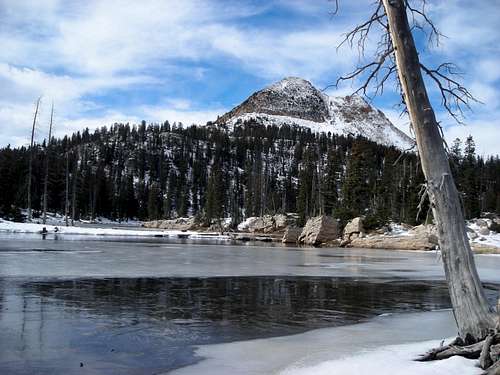 The differences are too obvious though. The lone fir tree on Island Lake is
  Just as I kept claiming that the key "KSL images #19 and #20" couldn't have been taken at Hidden Lake,


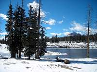
 KSL - no number but according to the uploading order it may have been taken between Hidden Lake and the "Little Meadow".
 The SAR shot
Dmitry Pruss - Nov 8, 2006 8:47 pm - Hasn't voted
PS - I noticed that you and Shanewere discussing the "appoximate final shelter location" on uutah forums. It is kind of funny to read his critique since I merely copied the location from his own article on climb-utah website :) And he in turn took it from a newspaper drawing back in 2004. But the news accounts were widely conflicting. Others put the spot closer to Hidden Lake, and one even said it was within 1.5 miles from the trailhead (really!)
Anyways ... I figured that not everybody reads the "figure legend" and so I just edited the picture, changing the little Shane'esque circle into a HUGE OVAL. So even the quickest glance at the map would make it clear that the final location remains a mystery.

Scott - Nov 9, 2006 9:09 pm - Hasn't voted
Re: PS - I noticed that you and ShaneYep, we were discussing it. I thought the little blue circle was an actual location. If it came from the media, it can't trusted for sure.
Dmitry Pruss - Nov 9, 2006 10:07 pm - Hasn't voted
If it came from the media, it can't trustedAs you said. I spoke with an ex-SAR guy who's been there and he didn't wanna give any more details other than "you won't find it". Out of fear of playing into morbid curiousity, I suppose. And there might be something right about it ... but since, so far, they've got almost everything in this story wrong, I think the cops may be wrong again.
Dmitry Pruss - Jul 11, 2007 5:08 pm - Hasn't voted
Two more images id'd, the final still elusiveJust completed adding another section to the article - the two last dead hikers' photographs locations have been identified.

yatsek - Dec 31, 2008 12:31 pm - Voted 10/10
Exertionphysical or mental stops the brain working properly - one just mixes up the simplest things; hypothermia can set in quite suddenly - in the 1930s in the Tatra Mts 2 men (one was a climber) + 1 boy aged 12 died just a few hours after they'd left a chalet. It was autumn, rain and wind, they'd just crossed the col and descended to the tarn in the cirque on the other side and - as the woman who was with them reported - suddenly all became delirious. Unfortunately, she treated each with a drop of cognac, after which they all passed away. And she, the only survivor, stayed by their bodies for over 30 hours till she managed to pull herself together and finally walked down the valley to the nearby village.
stripey22 - Nov 16, 2010 2:09 pm - Hasn't voted
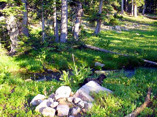
Resurrect this thread!I agree with your findings. I also think that mixing up North and South beyond Clyde is unlikely. The "Little Meadow" photo does not show weather as an immediate problem. The sky is quite light and visibility seems to be unlimited. This photo leads me to believe that these women might have known where they were and where they wanted to go. Why they stopped is the question. My question, is the Little Meadow due West of Hidden or is it WNW or WSW of Hidden? I believe the shelter location is much further South than most think and much closer to Hidden Lake. A likely North facing ridge or cliffband is a possibility just SW of Hidden and lies along a route that would be the one of least resistance for the victims after leaving Hidden Lake. I also question why a SAR member would say, "you won't find it"? Because he knows we all think it is somewhere it isn't?
Dmitry Pruss - Nov 16, 2010 6:21 pm - Hasn't voted
Re: Resurrect this thread!Wow, it's been over 3 years since anybody asked. WSW ... the coordinates linked to the picture are pretty good, and Google satellite images got better over these years.
Hmm, so your reasoning is that they knew what they were doing, and were trying to return to the car around the West side of Watson's? I crisscrosed a good deal of terrain in that corner, but probably not every nook.
As to the SAR ... he couldav been just dismissive, like you don't know shit ... or he might have known for a fact. Like if the picture of - supposedly - the final resting spot isn't really it. Who knows...
stripey22 - Nov 17, 2010 12:27 pm - Hasn't voted
Re: Resurrect this thread!That's my opinion. I think they knew about where they were and where they wanted to go. That's not to say they knew what they were doing. Most maps show that route around the West end of Watson looking pretty easy. The million dollar question is, like you stated, what caused them to stop? Family of the victims stated that they prepared their hike very carefully and that at least one of them was an experienced hiker. It's a very intriguing situation to say the least.
I plan to spend a couple days along the Middle Fork in the spring. I think I'll approach it around the West of Watson and leave by following the easiest route as I imagine they would have.
stripey22 - Nov 17, 2010 12:36 pm - Hasn't voted
Re: Resurrect this thread!I am ignorant as far as techno coords and all that. I use maps and a compass along with experience to do this kind of thing. If I were to start using a GPS, where or how would I find the coords attached to the photos? Thanks
Dmitry Pruss - Nov 17, 2010 2:31 pm - Hasn't voted
What makes one stop?Only 2 kinds of things could stop determined hikers on the way back to the trailhead: either they don't know where to go (lost, darkness, fog...) or they are physically unable to keep going (injury or exhaustion). Darkness or exhaustion are both unlikely given how little distance they actually covered after making their last photographs. So I'm pretty much sure that an injury has been involved. The true life-or-death question is, then, why they didn't separate?
If they weren't really sure about their location and route, that would make their fateful decision to stay together more reasonable.
As to GPS and stuff ... I'm with you 100%, a GPS device isn't a magic cure. It could even make things worse for clueless users sometimes. But what got me so interested in the story in the first place was how vehemently their kin insisted that a GPS would have saved them. No easier way to get a GPS buff like myself all fired up :) So of course, of course, I ended up recording coordinates of, like, everything on this quest.
To see the coordinates and the Google satellite photos: click on the image (you'll get here:
http://www.summitpost.org/the-little-meadows-shot-of-lost-hikers-revealed/310530)
and look at the right hand side of the page for the "Image Data" box, with a clickable location link (which says Lat/Lon: 40.70821°N / 110.98967°W). Clicking would get you to Google maps, where you may selected "Hybrid" for satellite images, and zoom in to see every tree around this little meadow and every twist of the creek running through it.
stripey22 - Nov 17, 2010 2:59 pm - Hasn't voted
Re: What makes one stop?Great points! I have seen first hand the consequences of an inexperienced GPS user trusting it's direction. GPS was correct but the user couldn't or wouldn't understand the info.
Thanks for the help with the links.
Over the years I have been involved in several searches in the area but not this one and it's this one that nags at my brain and won't stop.
brly - Nov 23, 2010 8:24 pm - Hasn't voted
Re: What makes one stop?It seems to me that they may have planned to circle Mt Watson. This would require minimal knowledge of the area without a map in hand. Following this and their last location, I would have stayed on elevation and gone South. Going to the West is heavily forested with steep declines. Going South may have placed them the one and a half miles from the trail head as was reported but farther South than was reported.
As was stated, this would also lead me to think there was an injury. Probably to the experienced hiker.
Dmitry Pruss - Nov 24, 2010 4:38 pm - Hasn't voted
Re: What makes one stop?Probably the more experienced hiker being injured - that's a very good point.
I definitely haven't explored the circle-the-Watson idea. Before identifying the location of the last images, I checked a good deal of terrain immediately to the South of this location (and a good deal more to the West where all these rocky fissures on the slopes overlooking Weber river are found). But I haven't venured to the South of a little glade at 40.705807,-110.993607 (that's some quarter mile from last image location). And on the satellite images you can see a few rocky belts further South, that's definitely something to check.
brly - Nov 27, 2010 1:13 pm - Hasn't voted
Re: What makes one stop?The area surrounding 40.70374, -110.99507 might be a good place to look.
After reading more of the media reporting on this story, it's even more curious. The more I read the stranger it seems.
The first rule they broke was by not letting someone know where they were and when they would be back.
One report said that the family claimed they were both experienced hikers. Other reports also said that one of them was a nurse.
When the remains were found, it was reported that there were no signs of a fire, yet it was reported that they had matches and that it appeared they were attempting to dry their clothes. I would assume that a nurse and experienced hiker would have known the signs of hypothermia and possible paradoxical undressing.
Stopping was not the problem. Staying alive was! Having GPS would not have helped that in any way.
ashergrey - Aug 28, 2011 3:14 pm - Hasn't voted
Re: What makes one stop?Just registered to say I've been following this page awhile and visited the area you mentioned yesterday. There is a small west-facing cliff band right there, but it doesn't match the SAR picture.
But I am now firmly in the "circle Watson" theory camp. I'm beginning to think they weren't actually lost and might have been hoping to reach the pack trail along the Middle Fork of the Weber so they could follow it out past Long Lake and to the trailhead.
Instead of heading straight west from the meadow location southwest of Hidden Lake, I believe they would have trended south toward 40.70374, -110.99507. There are rock bands east of there. Problem is, that becomes a climb. The meadow is at about 10,200 while the rocky areas in that region are at about 10,400. That 200 foot elevation gain is not insignificant, especially if you're accustomed to low-elevation, are hiking in poor weather and are exhausted.
I believe they would have trended south along the 10,200 mark seen on the USGS Mirror Lake quad, maybe descending gradually to around 10,000 when they were directly west of Watson. (40.698772° N / -110.997531° W ?) This would put them easily within 300 yards of the pack trail and would help explain why the Summit County SAR folks are so insistent that they had instead made a wrong turn coming from the Long Lake area.
As for why they sheltered there, injury is a likely factor but I'm also wondering if lightning could been a cause. They showed resilience hiking as far as they did in inclement conditions and it seems to me that they would have pressed on unless something dramatic compelled them to stop. If they'd never experienced high-elevation lightning, that could have been enough.
Dmitry Pruss - Aug 31, 2011 6:21 pm - Hasn't voted
Re: What makes one stop?Thanks for your continuing interest in this riddle! I checked the area of 40.70374° N 110.99507° W two or three times, even before homing in on the locations of the last photographs made by the doomed hikers. There is a notable meadow with a little glade some 200 yards NE from this location, and then just a bit further NE, a meandering stream in a meadow; I stopped by at both meadows many times, while scouting the rocky hillocks around. None were nearly as rugged as the "final shelter" picture, but it may be interesting to recheck more.
According to the news stories, the personal articles of the deceased were first found very close to a halicopter landing site during an S&R training exercise. So it would be most reasonable to look within a hundred or two hundred yards of a meadow or an open spot in the woods, where their chopper would have landed.
Have you visited the area? Having been there many times, I couldn't help feeling the aura of getting lost at an edge of civilization. As you wander off the official trail near the Divide Lakes, the trails grow fainter and fainter, the campsites become ever more overgrown and spaced further and further apart. But the terrain invites you downhill and further downhill, all the way to their last photo location. It sounds like the logic of lost hikers to me: to take notes of the few continuing signs of human vistation, and to keep walking downhill. If they truly intended to circle Watson on purpose, they might have taken a higher route, a traversing path of sorts, instead of needlessly loosing elevation?
ashergrey - Sep 1, 2011 12:20 pm - Hasn't voted
Re: What makes one stop?I think able-bodied hikers in good weather intending to circle Watson would trend uphill around the base of the mountain, but exhausted out-of-towners in inclement weather would follow the path of least resistance... generally downhill on the most gentle grade possible. I don't believe they would have moved above the tree line if lightning were present, which is a good possibility.
The picture of their final shelter is also perplexing. Part of why I suspect lightning is their shelter appears to be something they would have had to seek out, as opposed to a spot they just happened upon. From what little I've seen of that area, there are not many rock outcroppings that would have provided as good a shelter. There is a lot of exposed rock, but as you say none of it is quite as rugged.
Part of what makes this hunt so interesting is its proximity. I've hiked in areas far more desolate, both in the Uintas and elsewhere. At no point were these women all that far from the Mirror Lake Highway or the summer homes in Weber Canyon, but by going only about a mile off-trail, they ended up entirely isolated.
Dmitry Pruss - Sep 1, 2011 1:45 pm - Hasn't voted
Re: What makes one stop?Lightning is possible in early September, although this was a colder kind of a storm, one which would bring the snow to the Uintas the following day. Anyway the clouds don't look too stormy yet on their last photograph, which was made barely a third of a mile away, over easy terrain, from where you think they might have sought a shelter from lightning. Of course we can't exclude anything but the lighning threat theory sounds unlikely to me...
Speaking of exposed rock faces, have you seen the pictures which I grouped under Hidden Stream Canyon? That's exactly down the creek from the last photo location, and it does get surprisingly rugged in this rarely visited maze of ravines.
brly - Sep 10, 2011 11:28 am - Hasn't voted
Re: What makes one stop?So, they're on a day hike. They get so disoriented that they go in the opposite direction from their car near the end of the day? They keep going downhill in the wrong direction into rugged territory?
It just doesn't seem right to me, but I've been wrong many times before.
UtahHike - Aug 3, 2012 9:25 pm - Hasn't voted
Re: What makes one stop?I'm curious in what ways a GPS can lead someone astray? It seems like multiple people have said that? I'm curious because I have a Garmin GPS with maps, and also a sighting mirror compass I use with a paper topo map.
Comments
Post a Comment