Devil's Peak and Snow Mountain
Devil’s Peak and Snow Mountain
I drove up Hwy 80 from Sacramento and turned off the Soda Springs
exit right by Sugar Bowl. You work your
way over to Kidd Lakes Road which will take you by the entrance of the Royal
Gorge Cross Country Ski location. When
the road turns to gravel you continue for 3.5 miles ignoring the spurs to the
left and right until you come to a large turn out and the Royal Gorge Devil’s
Outlook Warming Hut. Parking here you
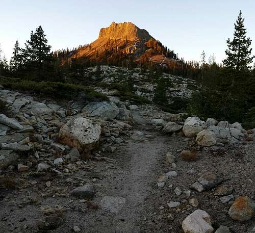
the steep North face of Devil’s Peak is directly in front of you.
From the
warming hut you continue down the dirt road which becomes rougher as you get
towards the spillway between the two Cascade Lakes. Continue south on the trail(Palisade Creek
Trail) for about a half a mile, until
you get to about the middle of Long Lake.
Here you will turn right off of the Palisade Creek Trail and begin
heading southwest towards Devil’s Peak.
If you find yourself heading southeast, away from Devil’s Peak, like I
did, turn around and look for a trail heading more to the east. Follow this unmarked trail heading to the
southwest until you hit a much wider 4wd road with switchbacks that leads you to
the north side of Devil’s Peak. This 4wd
road takes you up to the shoulder where you will want to take a steep trail
leading straight south towards the peak.
Once you
arrive close to the rocky gulleys of the peak you can start heading up. I headed up a hundred or two hundred feet in
this fun class 3 scrambling. At the top
of the scramble the true summit comes in to view. Here I did not feel safe going straight at
the summit any more from the north side, so I traversed over to the southwest
side to avoid the class 4 or 5 moves on the north side. After scrambling across the west side a much
more reasonable scramble to the top towards a notch near the peak came into
view. This class 3 scrambling was fun
and felt safe as I worked my way to the top
From the top
of Devil’s Peak Troy Road can be seen below to the west side of the peak. I decided to bushwhack directly towards paved
Troy road. Next time I probably would
have traversed back to the trail on the north side to avoid going straight down
a creek bed towards the road.
Once to Troy
Road you head south on the paved road for several miles and pass Huntley Mill
Lake on your right. At the end of the
paved road you will want to find a dirt 4wd road which heads to the
southwest. On the way there I found 4wd
roads that stopped and started, but on the way back I found the clear 4wd road
which made going a lot quicker. This 4wd
road seems to peter out somewhere about a mile or two from the peak. Staying on the aforementioned 4wd road
heading southwest will save you a lot of time.
Route finding on the way to Snow Mountain added about an hour on to my
day.
From here it becomes a cross country
ascent. Head a bit towards the west side
of the peak before contouring east up the ridge for the final couple hundreds
of yards. On top be sure not only to
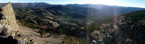
look at the views towards Devil’s Peak to the north but also towards the
American River Canyon Gorge to the southeast. I started at 6:30 a.m. and was back at the
warming hut at 12:30 p.m. and my route was exactly 14.3 miles.


Comments
Post a Comment