
|
|
Route |
|---|---|
|
|
40.75690°N / 110.6074°W |
|
|
Backpack/Scramble |
|
|
A few days |
|
|
Class 3 |
|
|
Approach
From the traffic light in Kamas and the intersection of route 248 and 32, head north 0.1 to SR 150 (Mirror Lake Highway). Turn Right onto SR 150 and follow for 49 miles to FR 058, turn right onto FR 058 (Dirt Road) and follow for 21.2 miles to the intersection with another dirt road heading north south. Turn right and follow road south for approximately 6 miles to the parking area at the East Fork Blacks Fork camping area and trailhead.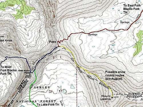 Red = East Fork Blacks Fork Trail. Yellow = Standard route up Mount Lovenia (no trail).
Route Description
The trail begins just down the road from the parking lot campground. A wooded board marks the trail. (You can save a little mileage by driving to the end of the road and ranger station, but this is not recommended because there is no bridge).Cross the river on a bridge. Enjoy the bridge because the rest of the river crossings are usually not bridged. Head south along the trail that follows the river. There is a junction about 1.3 miles from the trailhead. Keep your eyes open, because unless things have changed in recent years, it is easy to miss the trail junction and get in the wrong drainage (we did on our first trip). Turn right at the junction.
Once on the right trail, follow the trail all the way to Red Knob Pass-East (Note: There are actually three passes right near each other, and it has debated as to which one is the "real" Red Knob Pass. Different maps label different passes as Red Knob Pass). The trail climbs in elevation rather slowly until the very end, and the river crossings are the major obstacles along the route. If you're lucky, you can find a log to cross on, if not, you will have to wade. The pass is about 11.5 miles from the trailhead. There are several scenic campsites in the upper basin. We camped at 11,300 feet, above timberline, less than a mile short of the pass, but campsites farther down the trail provide more shelter.
From the pass, follow the gentle ridge south to another slightly lower pass. From the lower pass, climb southeast up the Northwest Ridge of Lovenia to the summit. The ridge is rugged and there are some cliffs to pass, but the route is obvious. The biggest obstacle is tedious scree on ridge. The climb is slow, but the views are fantastic.
 The East Fork Blacks Fork Trail winds it way up past 11,300 feet on its way to Red Knob Pass. Mt Lovenia is the obvious peak straight ahead.