
|
|
Mountain/Rock |
|---|---|
|
|
46.88730°N / 115.5276°W |
|
|
Clearwater |
|
|
Hiking, Bouldering |
|
|
Summer, Fall |
|
|
7043 ft / 2147 m |
|
|
Overview
 East Sister rises over a mile above the North Fork Clearwater River
 East Sister summit
 Looking east to The Nub
 Looking southeast
 Outcrops line the ridge
 Black Mountain from East Sister
Though the summit is only a little above 7,000 feet elevation, East Sister is impressive mountain for a number of reasons. It’s one of the highest mountains in the North Fork Clearwater basin and rises an impressive 5,400 vertical feet above the lush rainforests along the North Fork Clearwater River. It’s a difficult mountain to get to; requiring a nine mile hike on a trail that climbs 5,300feet and is intermittent in some areas. East Sister is the slightly smaller sister to Black Mountain, which lies nearly two miles to the west and is separated by 863 feet of prominence and two saddles on either side of a smaller ridge point.
East Sister is the second highest point in the Mallard Larkins Pioneer Area. This approximately 30,000 acre primitive area has been proposed for wilderness designation by the Forest Service for many years. Formal designation has never occurred, however it is managed similar to a wilderness area. This area offers some of the premier back county recreation opportunities in north Idaho with many peaks, canyons and 19 glacial lakes to explore. During peak hiking season, the main peaks of this area along the St. Joe/Clearwater divide get moderate to high use, but the slopes of East Sister are very remote with some of the upper basins and rugged canyons going years without a visitor.
In addition to the impressive physical features, the mountain has a number of other noteworthy characteristics. Being extremely steep, most of the mountain cannot be seen from below; in fact the first time the summit is visible is basically as you arrive. The summit area is formed by a large mound formed by a north-south running ridge or hump that has steep north, west and east sides. The south slope is much gentler and is the easiest way to the summit. There are four large drainages coming off the mountain that fall into remote deep canyons. Mountain hemlock covers most of the mountain but the east slope is an open subalpine grassland of sedges, green fescue and bear grass. Perhaps the most interesting feature is the hog back ridge formed by numerous rock outcrops that protrude intermittently along the upper ridge slope to the summit. These provide excellent bouldering and scrambling opportunities.
The mountain is very wet with the lower slopes being covered with a deep rainforest of western redcedar, grand fir and Pacific yew over a lush floor of sword fern, maidenhair fern and lady fern. In this zone, the high precipitation and warm low elevations provide and inland maritime climate that supports a high number of plants, mosses, lichens and even insects that are disjunct from their typical range in the wet forests west of the Cascade Mountains. Most of these species occur in the low moist forests, but a few prefer subalpine forests and montane grasslands of the upper elevations. Some are common, but others along with some endemic and widespread rare species give this section of the North Fork of the Clearwater the greatest concentration of rare species in Idaho. The inland existence of some of these coastal species has been discovered only in recent years and it is likely that more will be yet in the future.
Above the extensive cedar and grand fir old growth forests, the slope increases, causing soils to be more drained and thus support drier forest vegetation. The trees remain mixed conifer, but Douglas fir becomes dominant. This species typically lives 90-100 years in this area before succumbing to insect and disease outbreaks. The loss of this forest layer is evident here with large holes in the forest canopy and heavy layers of dead wood on the floor. At about 5,000 feet a zone of transition between mid-elevation mixed coniferous forests merges into open subalpine slopes with rocky soils, shrub glades, talus and the first subalpine tree species such as mountain hemlock and subalpine fir. Soon after the mountain hemlock become dominant, forming park-like forest over huckleberry, bear grass and wood rush. In many areas these trees are large and old, but near the summit the forest becomes more open with stunted trees and numerous rocky outcrops. Large avalanches have obliterated several acres of these forests at the base of the summit mound.
The trails around East Sister are thin and not always discernable. Often it’s best to just use the ridges to navigate the area, which is quite easy in the open floor of bear grass, woodrush and huckleberry under the hemlock forest. Avoid taking off cross country from the trails or routes. The downhill path of least resistance often quickly takes one into drainages that are very deep and full of wet, criss-crossing down logs, devils club and waterfalls. Climbing out is extremely difficult and passage down stream impossible. It’s an easy place to get lost and away from the trails the only way out is sometimes very dangerous. If you get injured in one of these canyons, it’s unlikely that anyone would ever find you.
Getting There
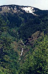 Waterfalls below West Sister
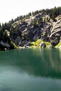
 Black Lake is along the way
 At the southwest saddle
 Up the west slope
If coming from Lewiston, follow Highway 12 to the town of Orofino and turn east across the bridge over the Clearwater River into downtown. Follow the main road through town (Michigan Street) and climb the grade east of town. This road is paved, but some places have a rough surface and some bad corners. Keep on this road for 26.5 miles to where it forms a T at the Bald Mountain Ski Area turn off. Take a left on the main road (Highway 11) and continue 7.3 miles to the next T at the small town of Headquarters. Headquarters is a small group of buildings that is an administrative center for the Potlatch Corporation; there are no services. Turn left at Headquarters (forest road 247) and continue for 24 miles to the bridge of the North Fork Clearwater River. On the north side of the bridge, turn right and go approximately 2 miles to Canyon Work Center. Go approximately a couple hundred yards past the work center administrative entrance to the trailhead parking on the right. This also serves as public parking to the Forest Service office at the work center, though the building is barely visible towards the river through the dense trees.
The Black Mountain trail (#396) is well signed on the north side of the road, immediately to the west of the parking area. It’s a steep seven mile hike to the where the trail forks with the left branch going to the summit of Black Mountain and the right path passing by Black Lake and on toward East Sister. The trail is not always present beyond Black Lake. It’s best to just keep on the contour and eventually get on the divide in the vicinity of the saddle on the southwest corner of the mountain. Follow the divide line to the south ridge, which is poorly defined at this elevation of the mountain due to the relatively broad slope. Once in the vicinity of the aspect change turn to the north and follow the ridge for nearly one mile to the summit. A good topo map will really help in this area. The forest will open up and the ground will become intermittently rocky amid giant outcrops as elevation increases.
If coming from the south, take Highway 12 to Kamiah and continue approximately 15 miles to Highway 11, which crosses the Clearwater River to the right at Greer. Then climb the steep 8 mile Greer Grade and continue on about 12 miles to Weippe. Here turn left and follow the signs to Pierce. Continue through Pierce about 5 miles to the Bald Mountain Ski Area turn off and then follow directions above. One can also skip the Greer Grade and continue to Orofino on Highway 12 and follow the directions above.
The Black Mountain Trail is generally easy to follow, but many areas are very steep and because there is little traffic on the mountain the brush closes up the path in many areas. In some particularly steep places be sure not to step off the obscured narrow path. The person at the Black Mountain Lookout reports that very few people hike up from the river. Of those who do, they mainly go to the lookout and Black Lake. The lower elevations probably see some increased use during the hunting season. With the modern use of helicopters in transporting fire fighters, crews don’t use trails as often as they once did. The result is many trails in this area being slowly reclaimed by the forest, especially east of Black Lake.
Part of the trail is not where its indicated on map. The southwest corner of section 27 shows the trail entering a long series of tight switchbacks straight up the steep slope. The trail has been relocated. After the first few turns in this stretch the trail continues east to the broad ridge line just inside the boundary of section 26. From there it gradually climbs to the junction of the trail between the lookout and Black Lake.
Extended hikes are possible to the east toward The Nub and north to the main divide of the Mallard Larkins Pioneer Area. However some of the trails may be sketchy in some areas. Bring along a good map and compass and be prepared for the possibility of doing your own route finding.
Red Tape
None.Camping

People wanting to car camp and have a long day hike can use the very scenic Aquarius Campground, which is a couple miles west of the trailhead or immediately upriver from the bridge crossing the North Fork Clearwater River. This campground is situated in old growth western red cedar against the rapids of the North Fork. There are only a few campsites so arrive early, especially if visiting the area on a weekend. There are some nice dispersed camping areas several miles up the river, some with nice sandy beaches. These are often full as well. Washington Creek campground is much larger and one can usually find a spot there, but this is getting quite a ways up river from Black Mountain. To the south of the river there are many dispersed campsites off the paved road along Beaver Creek that would provide good car camping. But most of these are filled up with loggers who work on the Potlatch timber lands in the area.
Backpackers can hike into Black Lake, which is less than two miles west of East Sister, where there are a few areas to pitch a tent. Very remote camping can be had in the open forests in the headwaters of Lower Twin Creek and the vicinity of the saddle between East Sister and The Nub. Other than these options, there is very little in the area for camping on the mountain.
When To Climb
The upper elevations get lots of snow and hiking the upper elevations before mid-July may be difficult some years. Most precipitation on the lower elevations is in the form of rain, thus the interesting montane rainforests on the lower slopes can easily be explored in winter. Of course this is depending on road conditions into the North Fork, which are not always open.Mountain Conditions and Information
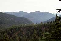 The Black Buttes from Goat Ridge
Go to the mountain prepared for variable conditions. With over a mile of vertical lift, mountain temperatures can vary dramatically.
Contact the North Fork Ranger District of the Clearwater National Forest for information and current conditions.
North Fork Ranger District
12730B Highway 12
Orofino, ID 83544
(208) 476-4541
Canyon Work Center (summer only)
(208) 476-8306
NOAA Forecast