

-
 4546 Hits
-
 71.06% Score
-
 1 Votes
|
|
Trailhead |
|---|---|
|
|
44.46151°N / 112.96348°W |
|
|
Beaverhead |
|
|
Spring, Summer, Fall |
|
|
8325 ft / 2537 m |
Access for Eighteenmile Peak
From I-15 to the trailhead is about 28.5 miles. But, if you want, you can drive most of the way at 45-50 mph. There is excellent signage at the road intersections, so you shouldn’t get lost.Cottonwood Creek crosses the road and you have to drive through a couple of other “water holes”, too. Only the last 50 or so yards up to the lake is rough and the only place you are likely to want 4-wheel drive.
From I-15 take Exit 23 at Dell.
Turn (south-southeast) onto the Westside Frontage Road.
Travel 1.5 miles and turn right (southwest) onto Big Sheep Creek Road.
Continue for 17.4 miles to the first Nicholia Creek road sign and stay left toward Nicholia Creek.
Go about 6.4 miles to the second Nicholia Creek road sign and follow its directions.
In about 0.8 mile, there will be a sign for Harkness Lakes. Follow its directions to the next Harkness Lakes sign in about 1.4 miles.
It’s only about 1 more mile to the Harkness Lakes.
External Links
For information about the climbers' route accessed from this trailhead, see the link included in the picture's description.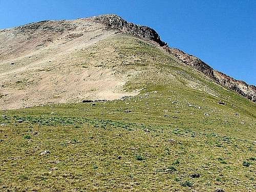 This is the northeast ridge to the summit of Eighteenmile Peak.