
|
|
Route |
|---|---|
|
|
52.21181°N / 3.66531°W |
|
|
Hiking |
|
|
Spring, Summer, Fall, Winter |
|
|
Most of a day |
|
|
Walking which can be tricky when crossing bog |
|
|
Overview
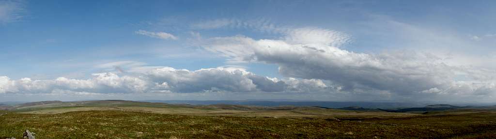
After reading the main Drygarn Fawr page some of you might be wondering why you should bother visiting this mountains summit. Well of course, it is has already been proven that the mountain is better than the Matterhorn, but it’s also the case that the mountain offers a rare sense of tranquillity and freedom that cannot be found in Wales’s most popular mountain ranges. For most people this route has the easiest starting point to reach, and can be combined with a visit to the reservoirs of the Elan and Claerwen Valleys, a region that is sometimes fondly referred to as the ‘Lake District of Wales’. On a clear day the views from Drygarn Fawr are spectacular spanning the hills of Mid Wales and beyond to the Preseli Mountains in the south west and Mynydd Mallaen, Mynydd Eppynt and the Brecon Beacons in the south. |
  |
Getting There
From Rhayader (SN 971 680) drive in a south-easterly direction on the A4518 along the Elan Valley towards the Caban-coch Reservoir. Drive along the northen edge of the reservoir and cross the Garreg Ddu Reservoir Dam and park at the Llanerch y Cawr car park (SN 900 616) at the end of the Caban-coch Reservoir. |
Route Description
The route starts at the car park (SN 900 616), and crosses the road and the bridge following the road around to the right. After about 100 yards the route turns left onto a track that is closed by a metal gateway. The route takes the track up Cwm Paradwys for nearly a mile to where it turns a hairpin to the left (SN 893 604). Here the route diverges from the track and carries on in a straightish line along a well trodden sheep track with Nant Paradwys down to your right.  Drygarn Fawr Drygarn FawrAs the route ascends the valley the stream of Nant Paradwys becomes gradually more distant and after approximately a mile and a half it reaches the head of the valley, Bwlch y Ddau Faen (SN 895 587) and a stone circle. From here the Brecon Beacons can be seen to the south. From the stone circle the route bears right and follows a line of concrete marker posts for about 100 yards. One of the large quartz topped cairns at Drygarn Fawr will soon come into view to the west about 2 miles away. The path is somewhat indistinct, however the cairn can be used as a target and the route heads straight for it keeping the worst of the eroded peat area to its left, skirting any very boggy bits (of which there are many), and follows any sheep tracks heading generally in the right direction. The going can be difficult, especially if there has been a lot of rain, however by keeping to the higher ground up to the right and following the line of concrete posts where possible, things can be made a bit easier. About half a mile from the cairns a very obvious track is met leading up the hill to the summit (SN 862 584).  Sheep on the summit Sheep on the summitIt is possible to turn the route into a horseshoe and avoid back tracking by descending to the north-east on a path (in reality nothing more than a sheep track) that keeps the eroded peat areas to the left and the lower cairn and crags to the right. The path soon come to a small stream in a valley (Nant yr Ast) and crosses the stream and turns left following the sheep tracks down to the Rhiwnant Valley. It then follows the right hand bank of the Rhiwnant downstream along a well marked trail. After about a mile the track bends around to the right opposite some old mine works and continues along the hillside with the river about 50 yards down to the left. After another half mile there are some more mine ruins either side of the river. Here the route diverges from the main path on the right and goes down left to join sheep tracks that runalong the stream bank. It then crosses Nant Paradwys just above its junction with the Rhiwnant and continue along the Rhiwnant bank for another 100 yards before taking the path up to the right and joining the stone track that the route started out on back to the car park. |
Essential Gear
Just a good pair of boots, waterproofs and some lunch. If walking in winter conditions make sure you also carry an ice axe and crampons. |
Maps
Guidebooks
The Cambrian Way – the mountain connoisseurs walk by A.J. Drake Cicerone Guide: The Mountains of England and Wales Volume 1 Wales by John and Anne Nuttall Cicerone Guide: Hillwalking in Wales Vol 2 by Peter Hermon |
External Links
 Larch woodland to the south of Drygarn Fawr Larch woodland to the south of Drygarn Fawr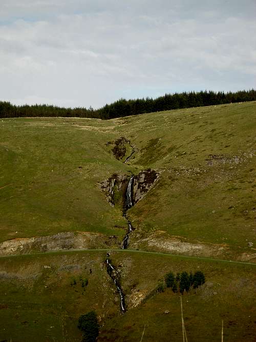 Rhaeadr Nant Ystalwyn Rhaeadr Nant YstalwynGeneral |