Getting There
The Porcupine Mountains lie on the shore of Lake Superior in the western part of Michigan’s Upper Peninsula, more or less due north of the middle of Wisconsin. It will take you at least a day’s drive from any sizeable city in the western Great Lakes except for Duluth. If you’ve been to the UP before, you already know that it’s a long way from any where.
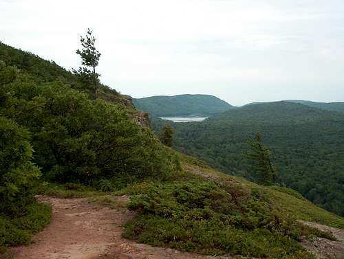
![Looking Back to Lake Superior]() First View from Escarpment
First View from Escarpment
Distances are approximately 150 miles from Duluth MN, 220 miles from Green Bay WI, 280 from Minneapolis MN, 330 from Milwaukee WI, 420 from Chicago IL, and 550 from Des Moines IA or Detroit MI. The last 200 miles or more in every direction are not divided highways, but fast two-lane roads that slow down to go through towns. Make allowances for this when estimating driving time.
The Porkies
![Lone Rock]() Lone Rock
Lone RockThe Porcupine Mountains (Porkies) consist of several ridge lines or escarpments rising from Lake Superior. Two of these rise significantly, with the highest about 1000 feet above lake elevation. There’s a small ridge line that features on parts of the trail here, rising only 100-200 feet above the lake.
The mountains are rugged by midwestern standards, and the park is a state-designated wilderness area. The park is home to a significant number of black bears, and there are wolves in the area. Most campsites have bear poles, though the Escarpment campsites (see below) do not.
The Escarpment-Lake Superior Loop
![Escarpment Trail]() Lake of the Clouds
Lake of the Clouds
This loop links the Escarpment, Big Carp River, and Lake Superior trails to make a good weekend loop hike. The highlights are Lake of the Clouds and the Big Carp River valley viewed from the escarpment, a long stretch close to Lake Superior, and the more subtle pleasures of the northern mixed forest.
This loop can (obviously) be hiked in either direction. If you go clockwise, it’s only a mile to the first night’s camp on the Escarpment, which has the best views in the park. There is no water there, but it’s only a mile hike so you can haul in what you need. You would then spend the second night on Lake Superior and hike out 7-10 miles on the third day. The loop doesn’t quite close, so you have to walk on the roadway for a half-mile or so to get back to your car.
Hiked counter-clockwise, you’d spend a night on Lake Superior and then either a second night on the Escarpment (hauling your water uphill) or hike back to your car. That’s not as attractive an option, but it’s the direction I hiked it.
The trail begins with a gentle descent through a cool, mixed forest. After a mile or so, the trail hits a rocky ridge with nice views of Lake Superior. From there, it descends on some annoying rocks - - basically scree consisting of well-eroded river rocks and pebbles. I met a trail runner coming up this stuff who had fallen and taken some nasty wounds. This is not a great place for trail running!
At the bottom of the ridge the trail runs a few hundred yards from the lake’s edge, giving the backcountry cabin (on the lakeshore) some privacy. After a half mile or so of this, the trail moves in closer to the lakeshore. The trail is pretty overgrown in places, and not marked when it moves out of the brush onto the rocky lakeshore, so keep your eyes open for the trail’s return into the woods.
Most of the campsites are on the lakeshore and thus essentially on the trail as well. The maps show an Adirondack-type shelter but this was a pile of old lumber when I passed it.
I camped at the first campsite after the shelter remains. For the first and only time in my life, I went skinny-dipping. One year later, Backpacker magazine named
this exact campsite as the best skinny-dipping in the country. Clearly, I'm a genius in the skinny-dipping department: but be advised, I cut my experience short when a tour boat started chugging along the shore.
About eight miles in, the trail climbs quickly up onto a small ridge, which it follows for most of the remaining distance to the Big Carp River. There are several cabins at the mouth of the river, and a number of campsites nearby, and it seems to attract people farther along the party end of the backcountry spectrum.
![Big Carp River]() Big Carp River
Big Carp River
From there, this route shoots up the hill and then follows the Big Carp River from a bank 50-100 feet above the river. This provides nice views, especially of Bathtub Falls and Shining Cloud Falls less than a mile in from the lake. This stretch, like much of the park, can be a bit soggy after a rain. Because the trail designers preferred to go straight up and down the hills, there are a fair number of slick spots as well as a lot of muddy bottoms. One large muddy basin was so criss-crossed by trails trying (unsuccessfully) to avoid the mud that it took some concentration to find the right route, which involved a turn.
There are abundant campsites through this stretch, most of which lie along the river. Those on the trail will therefore be looking down on you from the high banks. Exhibitionists may find this feature of the campsites attractive, but many of us will not.
After crossing the Big Carp River and turning left at a junction, a gently rising traverse and then a couple of switchbacks bring you to the Escarpment. The views here are grand, from Lake of the Clouds to the west, down the Big Carp valley to Lake Superior.
Red Tape
The Porkies are a state wilderness, not a federal one. Most of the rules are familiar to wilderness users. You do need to check in at the office and get a permit and a parking pass.
The fees add up for Michigan non-residents, with an entrance/parking fee and a nightly backcountry fee. These seem to be an increasingly attractive source of revenue each time I visit the state, so call ahead to find out the current rate.
One feature of the park is a bit unusual. It has many backwoods cabins available for rent, and these to be popular among dog owners. Supposedly you need to reserve these well in advance, in all seasons.
Climber's Log
If you've hiked this loop too, let us know at the Climber's Log
here.
Comments
No comments posted yet.