
|
|
Route |
|---|---|
|
|
46.93241°N / 121.84334°W |
|
|
Hiking, Mountaineering, Scrambling |
|
|
Summer, Fall |
|
|
Half a day |
|
|
YDS Class 2 |
|
|
Overview
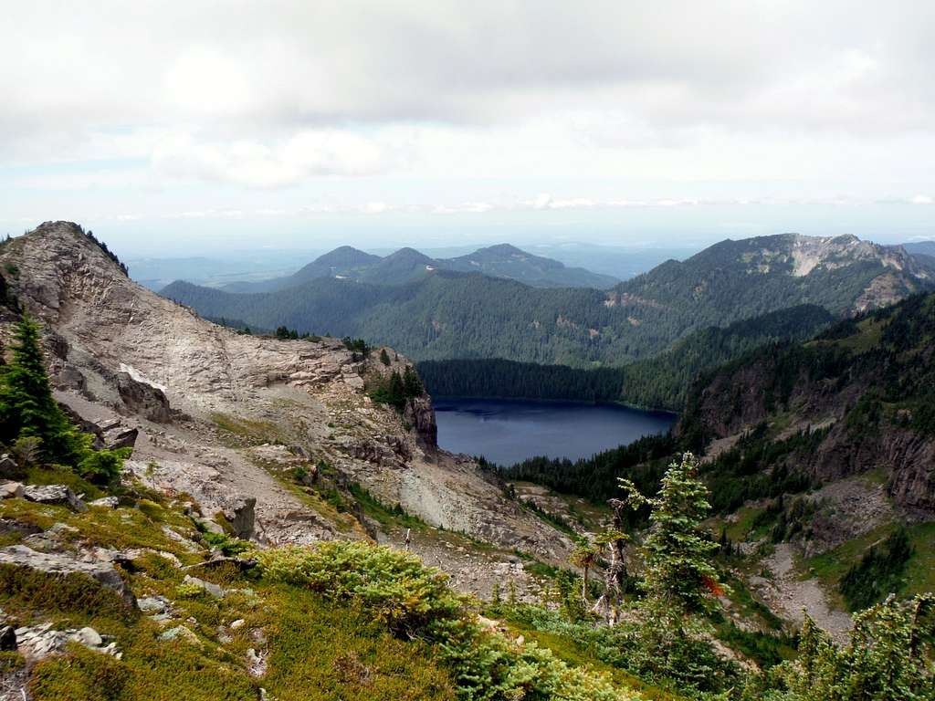
Mowich Lake
This traverse crosses some of the most scenic and rugged terrain in the whole immediate Mowich Lake area of Mount Rainier National Park. In terms of scenery this routes summits two rugged peaks while passing by a number of waterfalls. The terrain spends a lot of time above timberline and often traverses near cliffs and drop-offs. This would not be the place you would want to be during an electrical storm and it would not be safe in icy conditions. That all being said this traverse is home to excellent views of the surrounding region and stunning Mount Rainier views as well. It is easy to access during the summer with the whole traverse round-trip being no more than 5 miles and 1800 feet of elevation gain. Often nearby First Mother Mountain is combined with this route to make an excellent 3 summit full day experience.
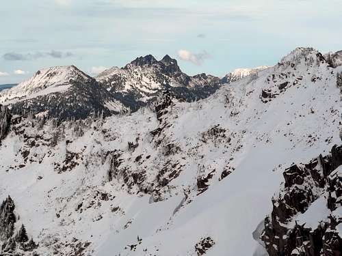
Not the ideal time to do this traverse
Though this route is only YDS Class 2 the route which in many areas is a well defined boot-path, one must pay close attention to the route or this route can get very rugged very quick. There were two areas that were catwalk, or places where the boot-path comes to the edge of a dropoff. Just off of Fay Peak the boot-path becomes very faded as it hits the low point on the ridge. I lost the path here and ended up side traversing steep heather until I found the boot-path later on the ridge. Because of this I urges other not to rush this traverse and to really take their time to as they follow the traverse.
Getting There
VIA THE MOWICH LAKE AND TOLMIE PEAK TRAILHEAD (RECOMMENDED IN SUMMER. KEEP IN MIND THAT THE MOWICH LAKE ROAD IS CLOSED USUALLY TO AT LEAST MAY AND MANY TIMES MUCH LATER!!!!): Take Route 165 South. It will soon intersect with Route 162. Continue on Route 165 south through the towns of Wilkeson and Carbonado. You then go over an older bridge over the Carbon River. This bridge is beginning to look unsteady and would not be a good place to be during an earthquake. Roughly a half mile over the bridge you will run into an intersection with one road veering right and head up Mowich Lake Road. You want to head up 17 miles up the road. You will run into the self pay area up at the Paul Peak Trailhead about 11 miles up the road. Don't forget to stop here because there are plenty of rangers at the Lake Mowich Campground and they will ticket you if you don't pay.Route Description
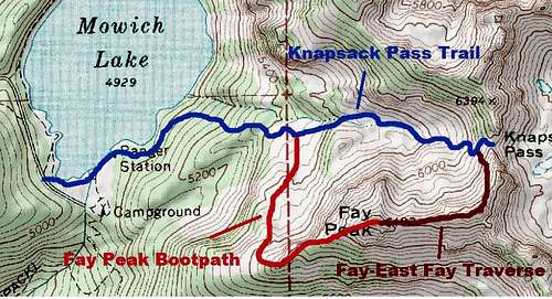
Map of the Routes up East Fay Peak
From the Mowich Lake Trailhead travel about 0.3 miles until you reach a ranger's cabin. From there look for an obvious bootpath unmaintained trail up from the cabin. This is considered by many as the Knapsack Pass Trail. It is not maintained but still well traveled. Take it up for 0.5 miles until the very first creek you run into. Right about there you will see the Fay Peak boot-path on your right. Take the Fay Peak Bootpath all the way to the summit of Fay Peak. This is Class 2 in parts with scrambling required in some areas. One can make it even up to Class 3 if one chooses a slightly different variation of the trail.
Bootpath/trail to Fay Peak
Once on Fay Peak continue to head east on the boot-path as it dives down into the gap between Fay Peak and East Fay Peak. Once at the back you will have to traverse to the south or right of a big rock which lies on the trail. It is key to try to stay on the boot-path because if one goes too far down the slope they will end up on steep slippery heather. Once back on the ridge the bootpath becomes well beaten in all the way to west side of the East Fay Peak. At the summit block the bootpath becomes a little rockier and one was really concentrate where they put their feet. The trail traverse to the north of the true summit where a faded side path more towards the eastern side will go sixty feet over to the true summit of East Fay Peak. Excellent views await from here. From here one must head down which looks from above a very challenging slope.
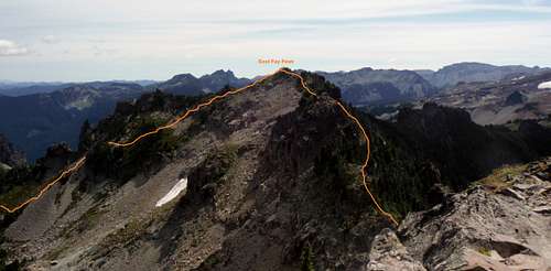 The traverse from Fay Peak. | 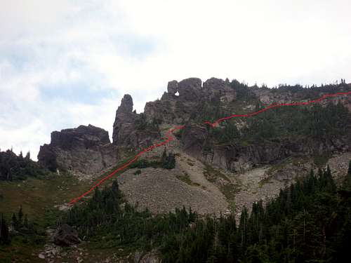 The eastern section of the route. |
It should be noted that even heading down the north slope of East Fay Peak the boot-path is pretty well kicked in. From all angles this section looks sketchy but actually turns out to not all that bad. One take the boot-path down the slope where there are some areas that do need to scrambled from time to time. About 200 feet from the end one must side traverse some scree and then head down a steep and faded boot-path to the Knapsack Trail located below. From there either take the Knapsack Pass Trail back or continue on and take the route to First Mother Mountain.
The eastern side of the Traverse from near Knapsack Pass.
Essential Gear
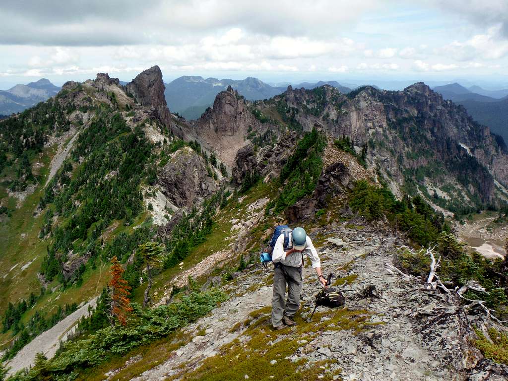
A properly dressed scrambler for this route.
This is a basic summer scramble. When there is no snow only essential hiking gear, and trekking poles are necessary. I personally would also though advise a helmet on this route though as well due to the fact there is a lot of rockfall on or near the route. When the route has snow an ice axe and some sort of traction device is an absolute must. In fact I would not do this route when there is a lot of snow on it due to the terrain that the route crosses.