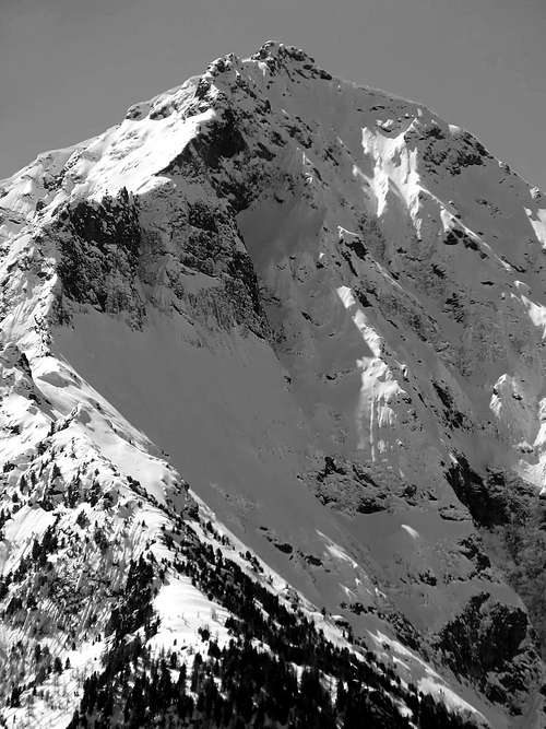
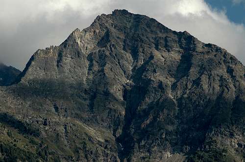
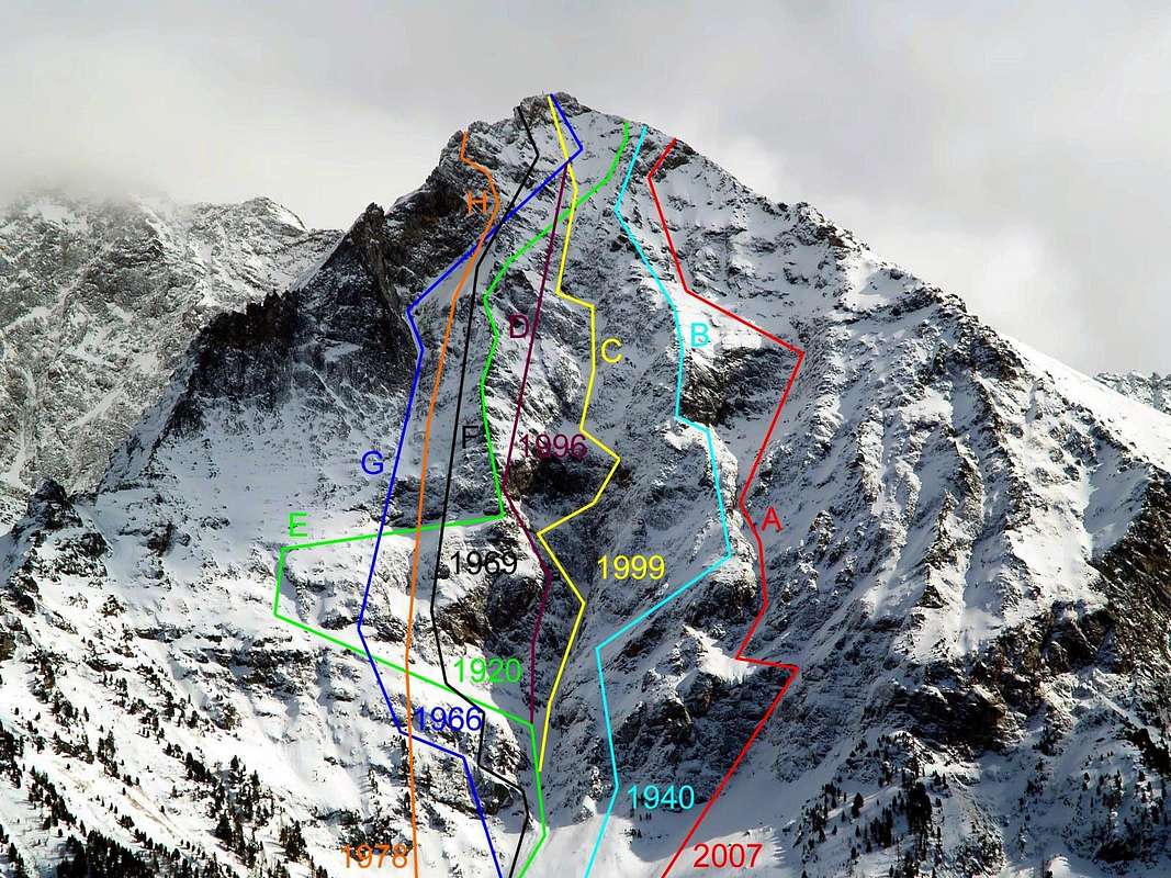
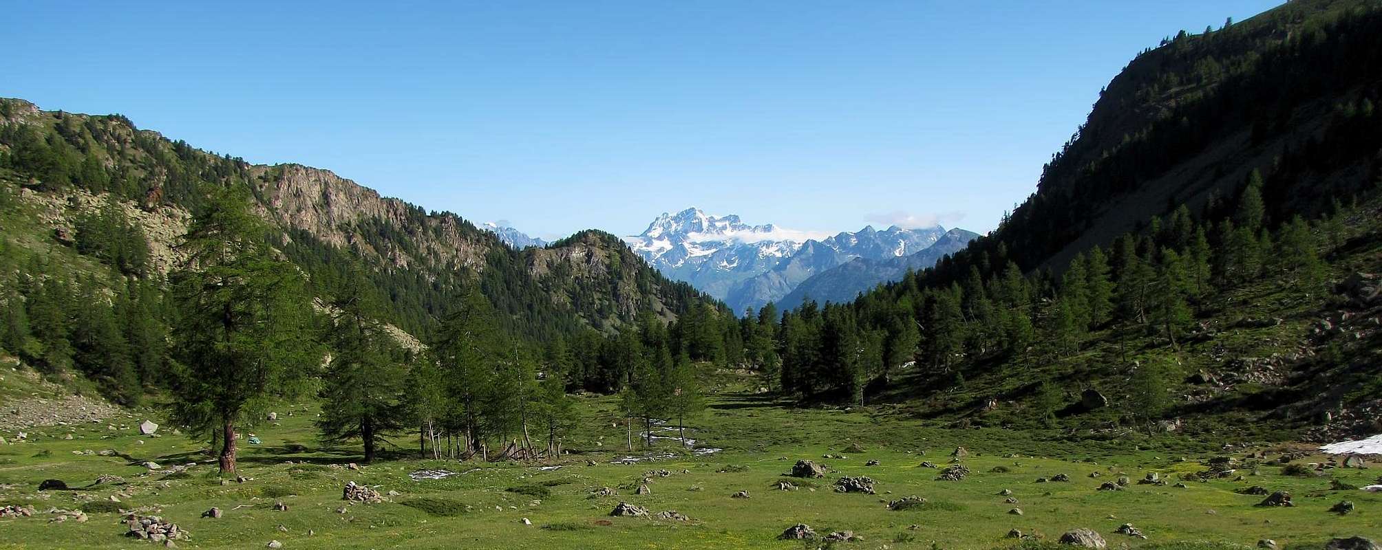
Great wall, mostly sets in the part in sight of this very regular pyramid, of triangular form perfectly, tall (850m around) and revolt toward Northern; it dominates from the tall one more of 2.500 meters the ancient City of Aosta, as well as the underlying Communes of Charvensod and Pollein, set to horse of the Comboé Torrent, that flows in the "Vallone" (Great Alpine Valley) of the Dard to the feet of the face. Un other stream it is born underground from its base (where a great stratum phreatic that opening, always more enlarged, has been provoked an enormous landslide during the flood in the year 2000 probably exists, with seven corpses in Pollein Saint Bénin, Chenaux and Chenière little Fractions) and it gushes out to east of the great vertical rocky-promontory wall said of the Moriond (they exist traced by the famous mountain climber Gian Carlo Grassi and Companions two beautiful routes in ice on two notable icy waterfalls, what, the one being turned to Northeast and the other Northwest, they actually icy maintain him to late Spring) and it gathers him to the precedent to quota 1.330 meters around, below the beautiful Cascade of Ponteilles and the below Pasture (1.706m; Sources of Morion, just over and in lateral to Southeast, from not a lot of time exploited for the expansion of the town aqueduct). On the same one, beginning from 1920 and actually to the last realization with a 2007 mountaineering "vie" along the dangerous Gully of Right also West, they have actually been traced to today eight runs on the whole wall; the same are developed along the his three great and evident couloirs, or along his two principal spurs Oriental or of Left and Westerner or of Right that, symmetrically climbing to the right and the left of the Great Central Gully, they sustain it supporting, what surly pillars, the whole rocky structure of the mountain. While the streets of the right side are completely autonomous and to itself stale, those on the left or Eastern Side have in common often some lines, above all to the height of the big triangular and suspended snowfield, sets in the part i mediate tall, or in the first 400 initial meters, where the run doesn't result to tightly be forced, where the run doesn't tightly result forced and such to allow numerous different variations of connection. The intermediary part results the most interesting (especially in the Central Couloir), while aloft the rock again has the tendency to crumble himself for any itinerary; interesting the "you go out" on the "Crestone" N-NE. Unfortunately the cheap quality of his rock it does not really help in climbing, at least done in complete safety: formed by mica-schist transformed with some modest intrusion of white-greyish gneiss.. The same macaws found exclusively in the Southern part of the basal "clog" of the East Wall, as well as in to little rocky gully of an underlying hundred meters the great horizontal ledge in the left side of the Northern Face; logic continuation of an intrusion coming from the Monte Emilius Wall North, where they abound. For the rest the whole mountain results formed from transformed micascist and with to spend some years more and more corroded, with cracks more and more widened by the phenomenon cold-thaw and filled by the soil; accordingly, progressively in the time covered by a grassy mantle), the mountain being rather ancient, he offers a delicate and dangerous scaling for the brittleness of the takings and grips and for the presence of grassy layers that they cover it, rather in greater increase in these last decades with "invasion" always greater in the median part and, lately, also tall of the wall. But, and above all, the little attraction toward the same one is to debit him to the notable exposure to the fall of stones and, in the beginning of season, of ice if not also of continuous small snowslides, you often notices in their frantic descent along the three couloirs, pulverizing itself above to the intermediary rocky jumps. The wall has never been climbed during the winter season, above all we think for the aforesaid motives. "She" remains, however, a symbolic wall for the very ancient Bourg of Aosta; twin and homologous of that North of the nearby and of 400 meters more elevated Monte Emilius (3.559 meters), of which it possesses the identical peculiarities as well as lines "somatic", geologic and structural. Even if less difficulty and binding, but taller (850 against the 670/80 meters around), a good ascension of training can be considered in beginning of season, above all if he still snowy. Overall, excluding the "combined" routes with the two opposite distinguished by the "Crestone" N-NE and Western Ridge, eight routes have been traced with about fifteen climbs, repetitions included. In fact, since 2000, the wall has shown a certain "awakening" by mountaineers, recording half a dozen ascents, but only aimed at the repetition of the itineraries carried out in the past century. But these two routes, however demanding and difficult, only partially cover the North Face: one in June 2008 via the "Canalino Est" of July 1966, and then deviate towards "Grande Torre" 2.998 meters; while the other, built at the end of December 2007, "touches" only the lower West part, turning in Northwest Face of the rocky Promontory 2.861 meters. All these routes are mainly the result of personal explorations carried out over a long period, or of impromptu initiatives, usually concluded with a single visit to this wild amphitheater near as well as above the city and at the same time out of this world ....
Grande parete, posta nella parte maggiormente in vista di questa piramide molto regolare, di forma perfettamente triangolare, alta (850 m all'incirca) e rivolta verso Settentrione; domina dall'alto di oltre 2.500 metri l'antica Città di Aosta, nonché i sottostanti Comuni di Charvensod e Pollein, posti a cavallo del Torrent de Comboé, che scorre nel Vallone del Dard, ai piedi della medesima. Un altro nasce sotterraneo dalla sua base (ove probabilmente esiste una grande falda freatica che, aprendosi sempre di più nel tempo, ha provocato un'enorme frana durante l'alluvione nell'anno 2000, con sette morti, nelle piccole frazioni di Saint Bénin, Chenaux e Chenière) e sgorga ad oriente del grande roccione-promontorio detto del Moriond (esistono tracciati dal famoso alpinista Gian Carlo Grassi e Compagni due belle vie in ghiaccio su due notevoli cascate, che, essendo rivolte l'una a Nordest e l'altra a Nordovest, si mantengono ghiacciate sino a Primavera inoltrata) riunendosi al precedente a quota 1.330 metri circa, al di sotto della splendida Cascata di Ponteilles e relativo sottostante Alpeggio (1.706 m; appena sopra e lateralmente a SE vi sono le Sorgenti d'acqua del Morion, da non molto tempo sfruttate per il potenziamento dell'acquedotto comunale). Sulla stessa, a partire da 1920 e sino all'ultima realizzazione con una via del 2007 lungo il pericoloso canalone di destra, sono stati tracciati sino ad oggi otto percorsi alpinistici; gli stessi si sviluppano lungo i suoi tre grandi ed evidenti couloirs, oppure lungo i suoi due principali Speroni Orientale o di Sinistra ed Occidentale o di destra che, salendo simmetricamente alla destra ed alla sinistra del grande Canalone Centrale, la sostengono sorreggendo, quali arcigni pilastri, l'intera struttura rocciosa della montagna. Mentre le vie del lato destro sono completamente autonome ed a sé stanti, quelle sul lato sinistro od Orientale hanno spesso dei tratti in comune, soprattutto all'altezza del gran nevaio triangolare e sospeso, posto nella parte medio alta, oppure nei primi 400 metri iniziali, dove il percorso non risulta essere strettamente obbligato e tale da permettere diverse varianti di collegamento. La parte intermedia risulta la più interessante (soprattutto nel Canale Centrale), mentre in alto la roccia tende nuovamente a sgretolarsi per qualsiasi itinerario; interessanti le "uscite" sul Crestone N-NE. Sfortunatamente la scadente qualità della sua roccia non giova sicramente all'arrampicata, perlomeno effettuata in piena sicurezza: risulta infatti formata da micascisti trasformati con qualche modesta intrusione di gneiss bianco-grigiastro. Gli stessi si trovano esclusivamente nella parte Meridionale dello zoccolo basale della Parete Est, nonché in un canalino roccioso d'un centinaio di metri sottostante la grande cengia orizzontale nel lato sinistro della Parete Nord; logica continuazione di un'intrusione proveniente dalla Parete Nord dell'Emilius, ove abbondano. Per il resto tutta la montagna risulta formata da micascisti trasformati e con il passare degli anni sempre più corrosi, con fessure sempre più allargate dal fenomeno gelo-disgelo e riempite dal terriccio; di conseguenza, progressivamente nel tempo ricoperti da un manto erboso. Quindi, essendo piuttosto antica la montagna, offre una scalata delicata e pericolosa per la fragilità delle prese ed appigli e per la presenza di strati erbosi che la ricoprono, alquanto in maggior aumento in questi ultimi decenni con "invasione" sempre maggiore nella parte mediana e, ultimamente, anche alta della parete. Ma, e soprattutto, la poca attrazione verso la medesima è da addebitarsi alla notevole esposizione alla caduta di pietre e, nell'inizio di stagione, di ghiaccio se non anche di continue piccole slavine, spesso notate nella loro frenetica discesa lungo i tre couloirs, polverizzarsi sopra ai salti rocciosi intermedi. La parete non è mai stata salita durante la stagione invernale, soprattutto pensiamo per i suddetti motivi. Permane, comunque, una parete simbolica per la Città di Aosta; gemella ed omologa di quella Nord del vicino e di 400 metri più elevato Monte Emilius (3.559 metri) della quale ne possiede le identiche peculiarità nonché linee geologiche, "somatiche" e strutturali. Anche se meno difficile ed impegnativa, ma più alta (850 contro i 670/80 metri circa), può essere considerata una buona ascensione di allenamento in inizio di stagione, soprattutto se ancora innevata. Complessivamente, escludendo le vie "combinate" con le due opposte Creste N-NE ed Ovest, fa registrare otto vie tracciate con una quindicina di salite, ripetizioni comprese. Dall'anno 2000 la parete ha denotato da parte degli alpinisti un certo "risveglio" facendo registrare una mezza dozzina di ascensioni, ma solamente rivolte alla ripetizione degli itinerari effettuati nel secolo passato, esclusi i due itinerari laterali che si concludono sulla Cresta Occidentale od alla "Grande Torre" sul lato opposto contraddistinto dal "Crestone" N-NE. Ma queste due vie, per quanto impegnative e difficili, percorrono solo parzialmente la Parete Nord: l'una nel giugno 2008 tramite il "Canalino Est" del luglio 1966, per poi deviare verso la "Grande Torre" 2.998 metri ; mentre l'altra, realizzata a fine Dicembre del 2007, "sfiora" soltanto la parte bassa Occidentale, rivolgendosi alla Parete Nordovest del Promontorio roccioso terminante a 2.861 metri sulla Cresta Occidentale. Tutte queste vie sono principalmente frutto di esplorazioni personali realizzate in un lungo periodo, oppure di estemporanee iniziative, in genere conclusesi con una singola visita in questo selvaggio anfiteatro vicino nonché proprio al di sopra della città ed allo stesso tempo fuori dal mondo ....
*
TOPOGRAPHIC, OROGRAPHIC and HYDROGRAPHICAL REMARKS The same one is divided in two parts (Oriental and Westerner) from a great couloir-gully rocky/snowy, that ploughs her in her center from the Summit 3.142 meters to the base, to quota 2.300 meters around; from this a great morainic grassland, ploughed by the continuation of the same gully, it steeply goes down up to the round great rocky promontory of the Morion(d) (Round Mountain from Mount Rion also from latin Rotundus Mons; 1.948m; of perimeter ruins of an ancient pasture, exploited still for the sheep farming to the beginnings of the '900) for then to rocky vertically fall inside the Dard Vallon or, better, a Gorge, underlying to that of the Comboé little Walley. On the right of the same a second basal channel, coming from the Couloir of Right of the wall, it goes up again, less steep and marked by the continuous landslides, toward the rocky base of the Western sector. This is Western sector is sustained by a great "clog" up the basal moraine, above which they are unfolded in progression, from the left to the right (West) and departing from the big Central Channel, a strong Spur West that it actually goes up again sinuous to 50 meters around from the Summit melting himself with the longe Crest West to Lower Comboé, a Gully of Right that accompanies it on its right alternated by four steep rocky jumps and a steep rocky wall, that it dies, always on the Crest West, on a small protuberance to quota 3.020/25 meters around. Over dark and to West, the wall descends gradually with to series of small couloirs rather interposed by steep rocky ribs;underlying to that of Comboé. On the right of the same a second basal channel, coming from the Gully of Right of the wall, it goes up again, less steep and marked by the continuous landslides toward the rocky base of the Western sector. This is sustained by a great basal "clog", above which they are unfolded in progression, from left to the right (West) and departing from the big Central Couloir, a strong Spur West that it actually goes up again sinuous to 50 meters around from the Summit melting himself with the Crest West, a Couloir of Right that accompanies him on his right alternated by four steep rocky jumps and a steep rocky wall, that it dies, always on the Crest West, on a small protuberance to quota 3.020/25 meters around. Over and more to West, the wall descends gradually with a series of small secondary and interrupted couloirs rather interposed by steep rocky ribs; underlying to this sector a dizzy big and channel, revolt more to North-northwest, goes down it stops us its run as soon as above the Ponteilles Alp and relative splendid Cascade. Very probably the snows or the descending waters from the wall with his, greater, channels have in the formed time one "ungluing" among the same one and the basal against slant, underlined by to great earthy crevasse, that flows by now at basic the of almost all the Western side; almost certainly below the moraine of the Morion(d) an enormous stratum phreatic is formed, destined to magnify him in the years to as. This phenomenon doesn't result to have been strengthened by the geologists yet; but from to personal inspection, comforted relative by tape VHS, of to two weeks of days after the 2000 Year Floods great landslide, with gone up again of the whole big gully "stricken", it was noticed out clearly to go out in the left or Oriental sector of the separation (as to whole they were three and held back by to great rockybanks of serpentinite green/bluish from the dimensions of to vessel) to throw of great water as an unloading of sewerage (to see the mini story under immediately afterwards).
**
The GREAT LANDSLIDE of the FLOOD in October of 2000 In the Year 2000 since Thursday 13th until Moonday 16th, cause the great flood that struck the whole Valley of Aosta, occurred an enormous landslide that, departing from a great fault to form of hole from letters, at the Western base of wall near the "clog", wide also 4 meters and long over 250 (in Jul of 1966 she was ascertained by the rope I. A. Garzotto-D. F. Cardellina-W. Ferronato, that had looked for at first to climb along the right sector of the wall, abdicating then you cause the precariousness of the rock, the presence of such wide earthy crevasse, then from the 20 to the 30 centimeters and along less than about twenty metres); the same descents in the bed of the ancient basal, of Northwest, couloir for over 700 meters with such a blow of double-bladed razor to devastate him completely, widening him than at least ten times and deepening him of almost the same. The same, reached the bed of the Comboé Torrent inside the Vallon of Dard, it upset the course of it and (formed a knapsack of water with material sundry near the Bridge of Rongachet 1.100m about) exploding in the forenoon of the Sunday of Oct 15 th, 2000, it got depressed on the Fractions of Saint Bénin, Chenaux and Chèniere, just overlooking the Commune of Pollein, causing the downfall and the death of seven people of it, among which a child; widening himself to fan also struck the Fraction of Pian Felina for then to relieve himself in the River Dora Baltea.
***
In its western extremity falls to great vertical wall of rock, apparently compact, that draws origin from the Quota 2.686 meters I.G.M (= Institute Geographical Military Italian) dizzy going down more to West toward the very narrow and in the shape of a funnel Walloon of the Dard, with relative as well as last gully of unloading. In the left or Oriental sector, always departing from the Central Couloir, he underlines an imposing Spur it is, such to serve as twin to be in opposition to the precedent. The same, departing from the great Ridge N-NE to around 100 meters from the Peak, it linearly goes down finishing with a big rocky jump above the entrance of the same couloir, to quota 2.400 meters around; more to east a vast and remarkable rocky-grassy "clog" extends him, very steep than the homologous one of right, that with run seeds circular it goes to melt himself with the "Crestone" N-NE finding its peak in her "La Dent" also "The Jag" (2.736m), where the same one is originated. This inferior and basal part unites the attack to the different routes of left of the wall and he is crossed by a small gully of drainage, coming from the superior triangular snowfield, formed by whitish greyish rocks, that it goes down, at first vertically for then to descend gradually tilted to West and along a great ramp, extinguishing its run near the beginning of the Central Couloir. A second, and still less evident and "broken" couloir, is originated at the base of the big jump of the great Crest N-NE to quota 2.670/80 meters around diagonally going down and in parallel to the precedent. This initial part of 450 meters around it exhausts him in a great horizontal ledge to quota 2.750/60 meters around; superiorly a trapezoidal wall of 250 meters raises him, around which culminates in a great snowy sheet (up to 30/40 years or are perennial), that goes to melt himself on the right (West) with the Spur it is and on the opposite side against the rocky jumps of the "Crestone" N-NE, to hundred meters below the same one.
*
MOUNTAINEERING NOTES
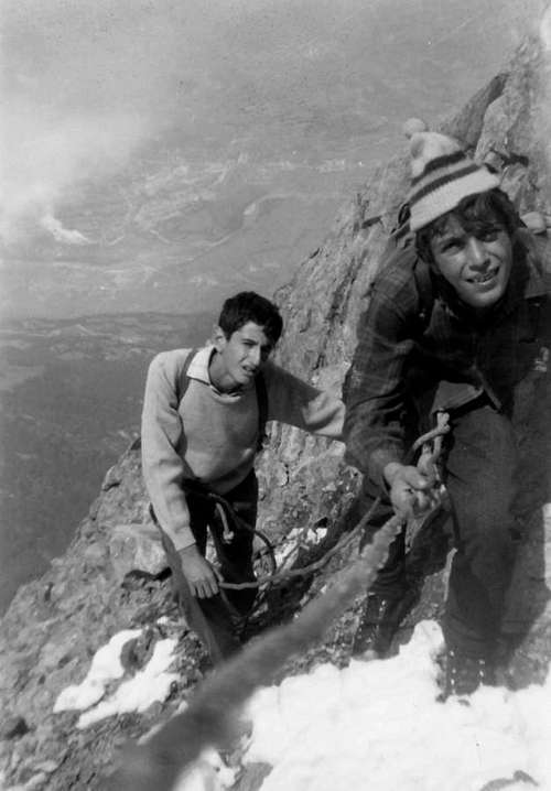
As mentioned above, in the arc of about ninety years you are been traced on the wall eight separate and different routes, besides the other combinated routes with North-northeast "Crestone" and in opposite Western Ridge, both with lonely climbing and in winter on December 31th, 2007 through the NW Face of rocky promontory 2.686 metri and Western Ridge and moreover on June 2008 along the "Via del Canalino july 1966" and the Western Wall of the "Gran Tour" finally to conclude on N-NE "Crestone" (you see under First Ascents, but even the page in SP "Becca di Nona (3.142m) Mixed Routes"). Since 1920 with the first absolute, through a run rather unhomogeneous, that he takes its beginning in the Oriental sector, goes up again for brief line the East Spur, it crosses the Central Couloir, it overcomes in the final part the West E'peron and, through the Crest West, it concludes in Peak. The last away crossed resolves the problem of the great Couloir of Right instead, with an ascension more dangerous than not binding, motive the dangerousness for the fall of stones (besides existing on all the routes of the wall) if not even of small landslides, as manifested him in the last ten years. The same has been realized with a solitary ascension in Oct of 2007; surely however the most binding street results to be the route of the horrid Central Colander, also it opened in solitary in 1999. While the routes of the big Central Gully, as well as the two of the right or western sector of the wall, introduces one well delineated and autonomous physiognomy through you climb completely to itself stale, those of the side immediately to the left of the same gully or Oriental, also having an own specificity of ascension, they can easily be combined between them with different variations; especially in the first 400 meters and that is up to the great horizontal ledge, positioned among the base N-NW of the Great Tower also "Grand Tour" 2.998m, sited in the midst of the "Crestone" N-NE, that descend from the Top to La Dent 2.736m (The Jag) and the part mostly delineated of the Spur of Left or East. Unfortunately the quality of its rock results not good, if not even very bad and this factor also explains the scarce number of slopes of it you effect, that doesn't reach the just about fifteen, as far as we know. A lot of her routes result more difficult dangerous and they are rather exposed to the falls of stones and, in beginning of season, of stick of ice. It was also climbed only once in winter with a solitary climb starting from Pila in one day. Therefore the high Northern Face it appears to have been climbed even in the bad season, in which result to ever have been effected during the almost end of winter 2006/7 (March 20th), where it appears even more from an analysis from the lower part dangerous and exposed to the snowlides. A lonely climbing made in day from Pila Resort, through Col Plan de Fenetre, Lower Comboé and crossing to the East towards the ancient Morion Alp (ruins). In the last years besides the rock, especially in the inferior part of the wall, he has progressively gone more and more to cover herself of grassy layers that of year in year they go up again toward the superior part of the same, while the rock has the tendency to decay more always, asking for a constant vigilance during the climb. Besides to annotate the difficulty to effect good safety, sees the difficulty of positioning of the nails into the rock for how much above statement. During the whole ascension, beautiful glimpses on the City of Aosta and in distance to North on the Alps Graians Chains from the GROUP of the Testa (Head) of Rutor to the whole Chain of Mount Blanc-Grandes Jorasses and until to the Mont Dolent, as well as on the Alps Pennine from Grand Golliaz, Velan, Group of Combins, Dent of Hérens, Cervino or Matterhorn up to the great GROUP of Rosa Mountain (three Breithorns, Pollux, Castore, two Lyskamms, Zumstein, Dufour, Gnifetti and Southern appendages).
*
OSSERVAZIONI TOPOGRAFICHE, OROGRAFICHE E IDROGRAFICHE La medesima viene divisa in due parti (orientale ed occidentale) da un grande canalone-colatoio roccioso/nevoso, che la solca nel suo centro dalla Sommità alla base, a quota 2.300 metri circa; da questa una grande prateria morenica, solcata dalla continuazione del canalone medesimo e segnata dalle frane, scende ripidamente fino al grande promontorio roccioso del Moriond o Morion (= Monte Rotondo; 1.948 m; rovine perimetrali di un antico alpeggio, ancora sfruttato per la pastorizia agli inizi del '900) per poi precipitare roccioso e verticalmente dentro il Vallone del Dard o, e meglio, Gorgia, sottostante a quello del Comboé. Sulla destra dello stesso un secondo canale basale, proveniente dal Canalone di Destra della parete, risale, meno ripido e segnato dalle continue frane, verso la base rocciosa del settore occidentale. Questo é sostenuto da un notevole zoccolo basale, sopra il quale si dispiegano in progressione, dalla sinistra alla destra (O) e partendo dal gran Canale Centrale, un robusto Sperone O che risale sinuoso sino a 50 metri circa dalla Sommità fondendosi con la Cresta O, un Canalone di Destra che lo accompagna sulla sua destra intervallato da quattro ripidi salti rocciosi ed una ripida parete rocciosa, che muore, sempre sulla Cresta O, su di una piccola protuberanza a quota 3.020/25 metri circa. Oltre e maggiormente ad O, la parete digrada con una serie di piccoli canali inframmezzati da costole rocciose alquanto ripide; sottostante a questo settore scende un vertiginoso grosso canale, rivolto più a N-NO, che ferma la sua corsa appena sopra l'Alpe di Ponteilles e relativa splendida Cascata. Molto probabilmente le nevi o le acque discendenti dalla parete con tutti i suoi, più o meno grandi, canali hanno nel tempo formato uno "scollamento" tra la medesima ed il contropendio basale, evidenziato da una grande crepaccia terrosa, ormai scorrente alla base di quasi tutto il lato Occidentale; quasi certamente al di sotto della morena del Morion(d) s'è formata un'enorme falda freatica, destinata ad ingrandirsi negli anni a venire. Questo fenomeno non risulta essere stato ancora assodato dai geologi; ma da un'ispezione personale, confortata da relativo filmato VHS, di una quindicina di giorni dopo la grande frana dell'Alluvione del 2000, con risalita di tutto il gran canalone "colpito", si notava chiaramente fuoruscire nel settore sinistro od Orientale del distacco (nell'insieme furono tre e trattenuti da una banconata di serpentinite verde/bluastra dalle dimensioni d'un vascello) un getto d'acqua grande come uno scarico di fognatura (vedi subito appresso).
**
La GRANDE FRANA dell'ALLUVIONEnell'Ottobre del 2000Nell'Anno 2000 dal giovedì 13 al lunedì 16 Ottobre, causa la grande alluvione che colpì l'intera Valle d'Aosta, si verificò un'enorme frana che, partendo da una grande faglia a forma di buca da lettere, alla base occidentale della parete nelle vicinanze dello zoccolo, larga anche 4 metri e lunga oltre 250 (nel Luglio del 1966 fu constatato dalla cordata I. A. Garzotto-D. F. Cardellina-W. Ferronato, che dapprima aveva cercato di salire lungo il settore destro della parete, rinunciandovi poi causa la precarietà della roccia, la presenza di tale crepaccio terroso allora largo dai 20 ai 30 cm e lungo meno di una ventina di metri); la stessa scese nel letto dell'antico canale per oltre 750 metri con una doppia rasoiata tale da devastarlo completamente, allargandolo di almeno dieci volte ed approfondendolo di quasi altrettanto. La stessa, raggiunto il letto del Torrente Comboé dentro il Vallone del Dard, ne sconvolse il corso ed (formata una sacca d'acqua con materiali varii presso il Ponte di Rongachet 1.100 m circa) esplodendo nella mattinata della Domenica del 15 Ottobre 2000, si abbatté sulle Frazioni di Saint Bénin, Chenaux e Chèniere, soprastanti il Comune di Pollein, causandone la rovina e la morte di sette persone, tra le quali un bambino; allargandosi a ventaglio colpì anche la Frazione di Pian Felina per poi scaricarsi nel Fiume Dora Baltea.
***
Nella sua estremità Occidentale precipita una grande parete verticale di roccia, da un'analisi dal basso apparentemente compatta, che trae origine dalla Quota 2.686 m I.G.M (Istituto Geografico Militare Italiano), scendendo vertiginosamente più verso O in direzione del veramente stretto ed a guisa d'imbuto Vallone del Dard, con relativo nonché ultimo canalone di scarico. Nel settore sinistro od Orientale, sempre partendo dal Canalone Centrale, si evidenzia un imponente Sperone E, tale da fare da contraltare gemello al precedente sull'opposto lato. Lo stesso, partendo dal Crestone N-NE a circa 100 metri dalla Vetta, scende linearmente terminando con un gran salto roccioso di oltre 100 metri sopra l'imbocco del canale stesso, a quota 2.400 metri circa; più ad oriente si estende un vasto zoccolo erboso roccioso, molto meno ripido dell'omologo di destra, che con percorso semi circolare va a fondersi con il Crestone N-NE trovando il suo culmine nell'isolata "La Dent" (2.736 m), ove trae origine il medesimo. Questa parte inferiore e basale accomuna l'attacco alle diverse vie di sinistra della parete ed é percorsa da un più piccolo canale di scolo, proveniente dal nevaio triangolare superiore, formato da più compatte rocce gneissiche di color bianco-grigiastro, che scende, dapprima verticalmente per poi digradare inclinato ad O e lungo una grande rampa, spegnendo la sua corsa nei pressi dell'inizio del Canale Centrale. Un secondo, ed ancora meno evidente e "spezzato" canale, si origina alla base del gran salto del Crestone N-NE a quota 2.670/80 metri circa scendendo diagonalmente e quasi parallelamente al precedente. Questa parte iniziale di 450 metri circa si esaurisce in una grande cengia detritica orizzontale a quota 2.750/60 m circa; superiormente si eleva una parete trapezoidale di 250 metri circa, la quale culmina in un grande lenzuolo innevato (fino a 30/40 anni or sono perenne), che va a fondersi sulla destra (O) con lo Sperone E e sul lato opposto contro i salti rocciosi del Crestone N-NE, ad un centinaio di metri al di sotto del medesimo presso rocce di colore sulfureo.
*
NOTE ALPINISTICHE
Come antecedentemento detto, nell'arco di una novantina di anni sono state tracciate sulla parete otto vie distinte e differenti, oltre a qualche via "combinata" con le due creste laterali. Queste due ultime entrambe con salita solitaria ed invernale il 31 Dicembre 2007 tramite la Parete NO del promontorio roccioso 2.686 metri e la Cresta Ovest dalla sua parte medio-inferiore alla Vetta. Nonché nel Giugno del 2008 lungo la "Via del Canalino luglio 1966" fino quasi al suo termine per poi "girare" sulla Parete Ovest della "Gran Tour"; per infine concludere sul Crestone N-NE (vedi sotto First Ascents, ma vedi anche la pagina sempre in SP "Becca di Nona (3.142m) Mixed Routes". Dalla prima assoluta nel 1920, tramite un percorso piuttosto disomogeneo, che prende il suo inizio nel settore Orientale, risale per breve tratto lo Sperone Est, attraversa il grande Canalone Centrale, supera nella parte finale lo Sperone Ovest e, per mezzo della Cresta Occidentale, conclude in Vetta. L'ultima via percorsa risolve invece il problema del Canalone di destra, con un'ascensione più pericolosa che non impegnativa, motivo l'esposizione alla caduta di pietre (peraltro esistente su quasi tutte le vie della parete, ma soprattutto all'interno dei canaloni) se non addirittura di piccole frane, come manifestatosi negli ultimi dieci anni. La stessa é stata realizzata con un'ascensione solitaria nell'Ottobre del 2006/7; sicuramente però la via più impegnativa risulta essere la percorrenza dell'orrido, molto esposto anche alla caduta di ghiaccio, e grande "Colatoio Centrale", anche essa aperta in solitaria nel 1999. Mentre le vie del Canalone Centrale, nonché le due del settore destro od Occidentale della parete, presentano una ben delineata ed autonoma fisionomia tramite salite completamente a sé stanti, quelle del lato subito a sinistra dello stesso canalone o settore Orientale, pur avendo una propria specificità di ascensione, possono essere facilmente combinate tra di loro con diverse varianti; soprattutto nei primi Grande Torre o "Gran Tour" 2.998 m. Questa trovasi situata nel mezzo del Crestone N-NE discendente dalla Vetta verso la Dent (2.736 m) e la parte maggiormente delineata dello Sperone di sinistra od Est. Purtroppo la qualità della sua roccia risulta non buona, se non addirittura pessima e questo fattore ne spiega anche il numero scarso di salite effettuate, che non arrivano alla ventina, per quanto é dato a sapersi. Molte delle sue vie risultano più che difficili pericolose e sono alquanto esposte alle cadute di pietre ed, in inizio di stagione, di candelotti di ghiaccio. Inoltre risulta essere stata effettuata durante l'inverno, dove appare, da un'analisi dal basso, ancora più pericolosa ed esposta alle slavine; il tutto in data 20 Marzo 2007 con salita solitaria effettuata in giornata da Pila, transitando dal "Basso Comboé" ed attraversando verso Oriente in direzione delle rovine dell'antica Alpe del Morion. Negli ultimi anni inoltre la roccia, soprattutto nella parte inferiore della parete, è andata sempre più progressivamente a ricoprirsi di strati erbosi che di anno in anno risalgono verso la parte superiore della medesima quasi raggiungendo la costola rocciosa fiancheggiante ad Ovest il grande nevaio triangolare nonché pensile, ormai in via di sparizione. Mentre la roccia tende a marcire sempre di più, richiedendo una costante vigilanza durante l'arrampicata. Inoltre da annotare la difficoltà di effettuare buone assicurazioni, vista la difficoltà di chiodatura della roccia per quanto sopra esposto. Durante l'ascensione, bei colpi d'occhio sulla Città di Aosta ed in lontananza verso Nord sulle Catene delle Alpi Graie dal Gruppo della Testa del Rutor all'intera Catena del Monte Bianco-Grandes Jorasses e insino al Mont Dolent, nonché sulle Alpi Pennine dal Grand Golliaz, Mont Velan, Gruppo dei Combins, Dent d'Hérens, Cervino fino al Gruppo del Monte Rosa (i tre Breithorn, il Pollux o Polluce, Castore, i due Lyskamms, Punte Zumstein, Dufour, e Gnifetti nonché le appendici Meridionali).
COLOR NOTE & Interesting REMARKS and INFORMATIONS
NOTES of COLOR The wall exposes a transformation of the very degradated rock being very ancient, from the geologic point of view; besides the possibility exists, not inusuale, of discharges of stones owed to the transit in crossing inside the wall of small steinbocks flocks (= ibex also mountain goats), phenomenon that is also verified on those some near Emilius, included the vertical, of 500 metres, East over Blantsette Glacier into marvellous Laures Valley, the gloomy North and the stately Black Triangle 3.378m, precipitating on Arpisson Vallon; it is recurrent, with provenance from the Laures and Arpisson, to find them, to a certain period (not disclosed and revealed!) in summer, in the steep slant that from the perimeter ruins of Morion Alp. Sign of an ancient pasture as the man and by now had been abandoning for long time, on which the happy ringing of the herds of cows doesn't resound anymore. Also the cry of the "Baccan" (from noise or shepherd of the herd, that it made noise in to call his beasts back) he has been silent, cancelling the panel of a remote, fair and legendary mountainous life of pasture in very tall mountain and the relative echo, coming from the box of resonance, formed by the great wall. It climbs toward basal clog of the same one. Then the "platoons/packs/flocks" of ibex, in the manner wolfs group, "they ferry" again, as swiss clock but in opposite, toward the Arpisson "Vallone" and they place him on the Emilius N-NE Edge (often on top of Triangle), from where they wary beware of the tall one of their stately horns to climb the intruders on the edge. So in the first sighting by the three Parish Priests Louis "Jean" Bonin, Pantaléon Bovet, Joseph Maria Henry, and of the Engineer Nino Tofani, in the first ascent of Aug 02th, 1906. With to pinch of imagination, you could also observe them to You caracoled among the Walls North and East, cross the two Glaciers Western and Oriental of the Arpisson, under the imposing Wall North of the Emilius with his vertical Black Triangle, to reach the tiresome, troublesome, irksome and rocky Peckoz Pass near the Becca of Seneva, to go up again to "Becca" des Boucs (Ibex Peak) or Testa Blantsette (= Festuca capillata Head graminacea difficult to mow and therefore it doesn't have any connection with the French blanche also whith) and to climb, hacked against the sky with inimitable safety, ability and elegance, on the splendid one and indented steep edge; Abbot Bovet's breast inflated him for the excitement to excess, to such it approves, sending forth every sort of exclamations oozed and seeped all of its passion of hunter, calling them with to whole series of small accompanied cries all the possible and unimaginable appellatives. But, for Heaven sake, don't tell it the hunters!! … Someone of them has already come to stroll about at the base of the wall, but, not knowing the exact season, it went with the "bagpipes" to the sack!!! It is everything been equal, all eternally peer, immutable and motionless, as if the time was eternally stopped in the ex Reserve of the Baron Beck Peckoz and actual of the Marquis Turati. The eternal "silent bustle" and the magic comings and goings of the steinbocks marks, what pits the pendulum, the time of the two monolitic clocks of Becca of the Ninth Hours and of Emilius and of their ridges and walls.Instead the thread of the West Ridge, in the impending tall part the exits from the itineraries A) - and B) -, "they walk" isolated chamoises or to small groups of two or three elements: also they could create some dangers moving the stones. The whole natural environment of Emilius Mountain Chain has been entire, at least as it regards the northern slopes and the small Sub-Group of Great Roise (Great Roizà in patois also dialectal language of Aosta Valley, with meaning of glacier); the same is comprehensive from Salè Tower in North to Leppe Point in South, in the watershed Les Laures/Saint Marcel Valleys. Particularly however the underlying basins the East Walls of the Becca di Nona at herly on the Arpisson and the North Face up the promontory of the Morion(d), as well as on the "Vallone" of the Dard, they macaws of an unique savage. The "shell" under this last it transports yourself in a lunar environment, you were almost out of the world; only the sight on the underlying ancient City of Aosta seems to reassure, bringing you to the reality. The feeling in the first morning, at the base of the wall, it is that to a wall to form of "scabby" beast with his hard, dark and incumbent features from the tall one of over 800 meters: but the DAWN and the SUN bring to the tranquillity, because the DEVIL is less ugly than imagined!
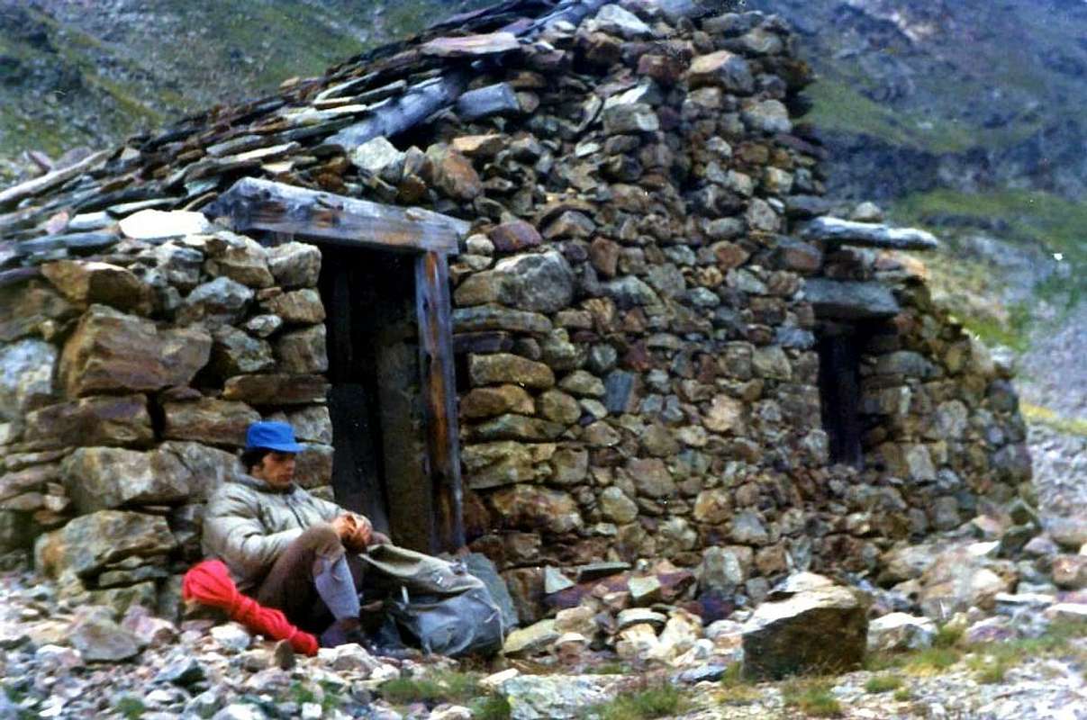
^ The RESERVE extends him from the Arpisson "Vallone", above the Commune of Pollein, to those Laures Valley, up Brissogne Commune, as well as Saint Marcel, actually to the crest watershed with that Clavalité Tableland also Fénis, over the homonym commune to plain. In the same one we find all alpine the animal and floral kinds, on which however the king stambecco (= ibex mountain goat) towers, of which find splendid image with statues in proper wood in front of the House of Hunting of Mulac in the "Vallone" of Saint Marcel. The regal flight of the eagle, with that inquisitional of the gypetus (of recent again inserted in the Valley of Aosta, together with the lynx, after the last sample killed in 1988 in the Valley of Rhemes) and that in form of arrow of the hawk, impends on the Coastline he dictates of the "Cordagnì" also Cordagnë (= the Cobbler in dialect patois valdotain) that it goes from the Mont Père Saint Laurent to Becca of Seneva and to Pecks of Boucs at it, near the Black Triangle of the Emilius; coming from this last (to nest as soon as under the peak of one splendid tawny sample with four meters opening to wingspan, slope Les Laures Valley), he is seen it rotate often above the Peak of Nona at, along its crests West and North-northeast and even occasionally inside the Wall North. Anywhere spread the marmot. ^ ^ To Carrel Pass (2.907m around with the neighbor Bivouac Federigo Zullo, positionated just over. He remembers the Abbot Naturalist/Mountaineer/Photograph "Valdostano" Jean Georges Carrel (1800-1870), drawing his origins from the Valtournenche Valley into Aosta Tall Hill, village or of Guides or of Abbots in other epoch, as much that an anecdote tells that the little children were launched by the window: if they fell to head in on they became Guides; to the opposite one they became Abbots or Priests. Known in whole Europe for one famous and renowned sketch of his with almost circular panorama to 360° of the Alps ("Les Alpes Pennines dans un jour" or "Pennine Alps in one day" nel 1855 Edited in Aosta, to which it followed "Chaine de la Grivola (Alpes Graies) vue de la Becca di Nona" also "The Chain of the Grivola (Graian Alps) view from Becca of Nona" in 1960, year when they were reunited, Edited in Turin, but dated 1855), really from the ummit of the "Becca", during an ascent with his Naturalist and friend Angel Sismonda. To him the Section of Aosta of the Italian Club Alpine also devoted in honor the name of the mountain, what "Pic Carrel"; the new baptism was not successful and neither taking possession, so much that remained the most ancient toponym of Becca di Nona (Peak of Nine Hours or Top requiring 9h'00 for the slope? Voilà! the busillis also here's the snag! We mostly slant for it before the two versions, because to the cold inhabitants of the Valley interested more surely the journey of the sun, that not how much time employed him to climb the "Becca").The ancient SHELTER of BARON BECK PECK(C)OZ, seriously demaged, ruined & spoiled on the contrary still in "life" on Aug 1976.
*
The bivouac, site between Becca and Emilius, exists, how point of support pratically alone profit for the return from the Wall North in particular conditions, the Federigo Zullo Bivouac (2.912m; always open, even in winter; natural toilettes over at the begin of "Via Ferrata", toward the Mount Ròss of Comboé-Little Emilius and Emilius (3.559m) ... sic" and sic!!), with 9 places bed, small table, seat, pillows and covers; little bottom the same one, near a minuscule (potable water) pond (2.873m), the old Shelter is found Beck Peck(c)oz of the Gamekeepers of the Baron (sees above the picture). Gone completely destroyed toward the end of the Seventies, he has recently been reconstructed, but it is of private ownership and therefore it is closed. ^ ^ ^ The DESCENT from Summit (3.142m), through the Carrel Pass, near Federigo Bivouac, (2.907m around) and towards Gros Scez Fork, Plan Valé Tableland to Comboés Valley. ^ ^ ^ ^ (Attainable in 0h'15/0h'20 from the Peak along the little and easy S-SE Crest). With this him through path n° 16 actually to an evident alternative and, immediately later from the same (evident yellow signals over a flat stone; to the same salt the other "By Normal", through a beautiful muletrack, ruined and slipped where only in the last 250 metres of the final part it becomes rocky, along the S-SW Slope.), easily going down toward left, through a small path with lines of soil and gravels, subject to small landslips, raison the snows melting; knowing how to look for, a little perennial source is found inside and under the small rocks in the most elevated part, just under the Top. From the same one, he goes down with the path, restructured by the Cooperative of" Haut Charvensod", n° 16A, before through a wide hairpin bends and, immediately after, with narrow zig-zag to the fork of Gros Scez (Great Squared Boulder; 2.526m. To West the other departs path n°16, sees above, along the grassy-rocky S-SW Slope, also it by Normal and that it connects aloft him to the precedent alternative of the Peak), to the Plan Valé (2.329m; ruins in a beautiful bloomed tableland, what seen by the tall one it appears with his moraine, rest of an very very ancient glacier by now from long extinguished time as the undulant skeleton of an enormous dinosaur; fireflys in the night) and to the Comboé (2.114m), arriving near a small wooden bridge up Comboé Torrent and, immediately after, near a nice minuscule loch just preceding the Comboés Pasture (2.110m about; spring and trough), with nearby little Churc, property of Saint Ours Canons. Other point of support they can be the Pastures of Ponteilles (1.607m) or of the Comboé Dessus and Dessous (2.114m; 2.041m; closed) and relative stalls for the cows (open), but always with analogous discourse. On the opposite or Northern slope instead the Hill descends gradually, overcome a small morainic "giogaia" (= mountain range in the shape of small and narrow basin), toward the Arpisson Western Glacier, under the majestic Wall North of the Emilius, along his reddish and remote glacial moraines toward the "Emilius Risings", where the waters "they explode" in surface out going out of ravines and small caverns among the "clapeys" (great stacked rocks). You can mostly be gone down also to West against the rocks of the Crest E-NE (not to confuse himself with the N-NE) of the "Pecks", whereas this ends with a great triangular wall; to foresee a descent more difficult, but very beautiful and "scheming" from the exploratory point of view in a splendid game for boys (you see photo). More in low a wide and enough extended tableland-highland (2.000 meters middly), between the "Becca" to West and the Mount Père Saint Laurent in East, ("troubled and beaten" by the spring avalanches coming from Crest N-NE of the "Becca" and of which perceives evident trace with the folding and gaunt trees from his powerful person puff), it introduces to the isolated Alps of the Superior (2.005/10m) and Inferior Arpisson (1.951m), in the rather wild, lonely and homonym vallon.
^ ^ ^ ^ ^ And an interesting ALTERNATIVE, transiting from the wild and lonely Valley of the Arpisson, to the feet of the imposing Wall NORTH of the EMILIUS ^ ^ ^ ^ ^ ^ Even accessible through various paths of base with starts from Pollein or from Reverier Dessous (1.042m), in Charvensod, and near Bridge of Rongachet and Alps (see Approaches). From where continuing with and along the dirt road or through short cut-path n° 13, that transiting through the Gorrettaz (1.089m) and Barmes also La Barma (1.255m) mini Villages, for Martsaouchy Désott; go up to du Meitin (1.362m about) and Damon (.1430/5m around) and it is reached with path-muletrack always n° 13 the promontory of Plan Croix (1.745m; in undoing; old aqueduct "suspended" and in wood, by now difficult to retrieve if the territory is not known) well and, doubling to basic the "Crestone" N-NE of Nona Becca, it gets in us in the solitary and wild Walloon of Arpisson, with his beautiful Cascade, not visible unfortunately, going up, since hidden really in the mean of the vallon. He can be admired her in distance from the fund valley, otherwise in the underlying place of Terreblantse Dessus (= High White Earth; 1.064m), slightly moving himself to East, through the path n° 1, and inside the same one; continue in direction to "headlong" and impetuous Arpisson Torrent, what it goes down engraving deeply the valley and flowing near the Fractions of Moulin (from where Mill, because in ancient times utilized; 605m) and Tharençan (572m), in the Municipality of Pollein. ^ ^ ^ ^ ^ ^ ^ Also possible with more directly slope at South, through path n° 13D/14 with departure from the Alp, isolated into forest below the rocky-wooden promontory of Plan Croix, called La Barma also Les Barmes (The Pasture included into a meadow terracing) and following crossing to Ponteilles Alp and nearby Waterfall, as far as the fork with the path-muletrack n° 13 in quota 1.480m about, and preceding itinerary to Arpisson's Vallon. Wanting, he could also be departed for the Wall by these with to crossing, through the path of connection n° 15A, at the base of the great Crest N-NE toward the Morion(d) old Pastures; it would deal with to unusual start, even if then even too much illogical, and for this motive he has not been inserted in the list of the Approaches (sees under the Section n° 4 "Approaches").
NOTA di COLORE
La parete presenta una traformazione della roccia molto degradata, essendo geologicamente antichissima; inoltre sussiste la possibilità, non inusuale, di scariche di sassi dovuta al transito in traversata dentro la parete di piccoli branchi di stambecchi e qualche isolato camoscio, fenomeno che si verifica anche su quelle del vicino Monte Emilius, compresa la verticale Parete Est sopra il Ghiacciaio Blantsette nel Vallone delle Laures, nonché la tetra Parete Nord ed il suo maestoso Triangolo Nero precipitanti sui due Ghiacciai Orientale ed Occidentale dell'Arpisson; è ricorrente trovarli, provenienti da questi stessi valloni, in un certo periodo dell'estate (non svelabile!), nel ripido pendio erboso-morenico che dalle rovine dell'Alpe del Morion. Segno di un pascolo antico quanto l'uomo ed ormai abbandonato da lungo tempo, sul quale più non riecheggia l'allegro scampanio delle mandrie di vacche) sale verso lo zoccolo basale della medesima. Anche il grido del "Baccan" (= da baccano o pastore della mandria, che faceva chiasso nel richiamare le sue bestie) è rimasto silente, cancellando il riquadro di una remota, leggiadra e leggendaria vita alpestre di pascolo in elevata montagna ed il relativo eco, proveniente dalla cassa di risonanza formata dalla grande parete. Poi i "plotoni" di stambecchi, a guisa di branco di lupi, "traghettano" nuovamente in senso contrario, come orologi svizzeri, verso il Vallone dell'Arpisson e si piazzano sullo Spigolo N-NE dell'Emilius (spesso in vetta al Triangolo Nero dell'Emilius 3.378 m), dall'alto del quale osservano diffidenti, esponendo le loro maestose corna, salire sulla cresta questi intrusi di alpinisti. Come avvenne nel primo avvistamento dei tre Curati Louis "Jean" Bonin, Pantaleone Bovet, Joseph Maria Henry e dell'Ingegnere Nino Tofani, nella prima salita del 2 Agosto 1906. Con un pizzico di fantasia, anche Voi li potreste osservare caraccollanti tra le due Pareti Nord ed Est, attraversare i due Ghiacciai Occidentale ed Orientale dell'Arpisson, sotto l'imponente Parete Nord dell'Emilius con il suo verticale Triangolo Nero, raggiungere il faticoso, ostico e roccioso Col Peckoz presso la Becca di Seneva, risalire alla Becca des Boucs (= Becca degli Stambecchi) o Testa Blantsette (= Testa della Festuca capillata, graminacea difficile a falciarsi graminacea difficile da falciare e quindi non ha alcuna attinenza con il francese blanche ovvero bianco) ed arrampicarsi, stagliati contro il cielo con impareggiabile abilità "alpinistica" ed eleganza, sullo splendido e dentellato spigolo; il petto dell'Abate Bovet si gonfiò per l'eccitazione a dismisura, a tal vista, emettendo ogni sorta di esclamazione trasumante e trasudante tutta la sua passione di cacciatore, chiamandoli tramite una serie di gridolini e con ogni tipo di appellativi possibili ed inimmaginabili. Ma, per carità, non ditelo giammai ai cacciatori!! Già qualcuno di loro é venuto a gironzolare alla base della parete, ma, non conoscendo la stagione esatta, se ne andò con le pive nel sacco!!! … Tutto é rimasto uguale, immobile ed immutato come se il tempo si fosse eternamente arrestato, nell'ex Riserva del Barone Beck Peckoz ed attuale proprietà del Marchese Turati. L'eterno "silenzioso trambusto", nonché il magico andarivieni degli stambecchi segna, quale fosse il pendolo, il tempo dei due monolitici orologi della Becca dell'Ora Nona e dell'Emilius e delle loro creste e pareti. Invece sul filo della Cresta Ovest, nella parte alta sovrastante le uscite dagli itinerari A)- e B)-, "passeggiano" camosci isolati od a piccoli gruppi di due o tre elementi; anch'essi potrebbero creare dei pericoli smuovendo le pietre. Tutto l'ambiente naturale nella Catena dell'Emilius é rimasto integro, almeno per quanto concerne i versanti settentrionali, nonchè nel piccolo Sottogruppo della Grande Roise (= da Roizà, che in patois o dialetto valdostano ha significato di ghiacciaio); in particolare però le conche sottostanti le Pareti Est della Becca sull'Arpisson e la Nord sul promontorio del Morion(d), nonché sul Vallone del Dard, sono di un selvaggio unico. La "conchiglia" ai piedi di quest'ultima ti trasporta in un ambiente lunare, quasi fosti fuori dal mondo; solo la vista a piombo sulla sottostante ed antica Città di Aosta pare rassicurare, riportandoti alla realtà. La sensazione nel presto mattino, alla base della parete, é quella di fronteggiare una muraglia a forma di bestia rognosa con i suoi lineamenti duri, scuri ed incombenti dall'alto di oltre 800 metri: ma l'ALBA ed il SOLE riavvicinano alla tranquillità, perché il DIAVOLO è meno brutto di quanto immaginato!
^ La RISERVA si estende dal Vallone di Arpisson, sopra il Comune di Pollein, a quelli delle Laures, sopra il Comune di Brissogne, nonché di Saint Marcel sino alla cresta spartiacque con quello della Clavalité o Fénis, al di sopra del comune omonimo. Nella medesima (di privata proprietà) riscontriamo tutte le specie animali e floreali alpine, sulle quali però troneggia il regale stambecco, del quale troviamo splendida immagine con statua lignea, proprio davanti alla Casa di Caccia del Marchese Turati in quel di Mulac, nel Vallone di Saint Marcel. Il volo alto e regale dell'aquila, quello inquisitorio e roteante del gipeto (di recente riinserito in Valle d'Aosta, insieme alla lince, dopo l'ultimo esemplare ucciso nel 1988 in Valle di Rhemes), nonché quello sfrecciante del falco, incombono sulla Costiera detta del "Cordagnì" o Cordagnë (= il Calzolaio, in dialetto patois valdostano), che s'allunga dal Mont Père Saint Laurent alla Becca des Boucs, presso il Triangolo dell'Emilius. Proveniente da quest'ultima (un nido appena sotto la vetta di un fulvo e splendido esemplare con apertura di quattro metri, versante Les Laures), la si vede aleggiare spesso sopra la Madonnina di Vetta della Becca, lungo le sue creste Ovest e Nord-nordest ed all'interno della Parete Nord. Ovunque é straordinariamente diffusa la marmotta, che denota problemi di sovraffollamento. ^ ^ La discesa dalla Vetta (3.142 m), tramite il Colle Carrel (2.907 m circa) verso il Bivio del Gros Scez ed il Plan Valé in direzione del Vallone di Comboé. ^ ^ ^ Al Colle Carrel (2.907 metri circa con il viciniore Bivacco Federigo Zullo, posto subito a monte. Ricorda l'Abate Naturalista/Alpinista/Fotografo Valdostano Jean Georges Carrel (1800-1870), traendo le sue origini dalla Valtournenche, villaggio o di Guide o di Abati in quell'epoca, tanto che un aneddoto racconta come i bambini piccoli venissero lanciati dalla finestra: se cadevano a testa in su diventavano Guide; all'opposto divenivano sicuramente Abati o Preti. Noto in tutta Europa per un suo famoso disegno con panorama quasi circolare a 360° delle Alpi ("Les Alpes Pennines dans un jour" o "Alpi Pennine in un giorno" nel 1855, al quale seguì "Chaine de la Grivola (Alpes Graies) vue de la Becca di Nona" o "La Catena della Grivola (Alpi Graie) vista dalla Becca di Nona" nel 1960, anno in cui furono riuniti, tutti e sempre con pubblicazione Edita in Torino, ma datate 1855), proprio dalla sommità della "Becca", durante una salita con il suo amico Naturalista Angelo Sismonda. A lui la Sezione di Aosta del Club Alpino Italiano dedicò in onore anche il nome della montagna, quale "Pic Carrel"; il nuovo battesimo non ebbe grande successo e neppure presa, tantoché permase il più antico toponimo di Becca di Nona (Picco dell'Ora Nona o Sommità richiedente 9h'00 per l'ascensione? Ecco il busillis! Noi propendiamo maggiormente per la prima delle due versioni, chè agli infreddoliti valligiani caleva sicuramente di più il tragitto del sole, che non quanto tempo si impiegasse per salire la "Becca").
Il bivacco (inaugurato nel Luglio del 1984), sito tra la Becca e l'Emilius, esiste come punto di appoggio utile praticamente solo, in caso d'emergenza per ritardo nell'ascensione (fatto di già verificatosi nella salita del 1996 (vedi sotto e foto) oppure in caso di maltempo, per il ritorno dalla Parete Nord, il Bivacco Federigo Zullo (2.912 m; sempre aperto, anche in inverno; toilettes "naturali" appena sopra all'inizio della Via Ferrata sulla Cresta NO che si indirizza al Mont Ròss de Comboé-Piccolo Emilius ed all'Emilius (3.559 m) sic! ... ed ancora sic!!), con 9 posti letto, tavolino, seggiola. cuscini e coperte; acqua poco sotto il medesimo, presso un grazioso laghetto (2.873 m), ove si trova il vecchio Rifugio Beck Peck(c)oz dei Guardiacaccia del Barone (vedi sopra foto). Andato completamente distrutto a fine anni Settanta, è stato recentemente ricostruito, ma è di proprietà privata e pertanto risulta chiuso. ^ ^ ^ ^ (Raggiungibile in 0h'15/0h'20 dalla Vetta lungo la facile e breve Cresta S-SE). Con questa si divalla tramite sentiero n° 16 sino ad un bivio evidente (segnalazione in giallo su di una pietra piatta; allo stesso sale l'altra "Via Normale", per mezzo di una bella mulattiera, franata solo negli ultimi 250 metri della parte finale ove diviene rocciosa, lungo il Versante S-SO) e, subito dopo, scendendo verso sinistra, con un piccolo sentiero con tratti di terriccio e ghiaie franose ed erose dalle acque di scioglimento delle nevi; sapendo cercare, trovasi nella parte più elevata una sorgentina perenne, sgorgante dentro e sotto le roccette, appena al di sotto della Vetta. Eppoi, giùinfondo, una lieta sorpresa per chi s'andar in montagna non sol con le piotte … Dal medesimo, si discende con il sentiero, ristrutturato dalla Cooperativa di "Haut Charvensod", n° 16A, dapprima con larghi tornanti e più in basso con stretti zig-zag al bivio di Gros Scez (= Grande Masso Squadrato; 2.526 m; ottimo punto di sosta. Ad O parte, come sopraddetto, l'altro sentiero n° 16 lungo il Versante S-SO, anch'esso Via Normale collegantesi in alto al precedente bivio sotto la Vetta), quindi al Plan Valé (2.329 m; rovine perimetrali in un bel pianoro fiorito, che, visto dall'alto lungo la "Via Normale alla Becca", appare con la sua morena, resto di un antichissimo ghiacciaio ormai da lungo tempo estinto, come lo scheletro ondulante di un enorme dinosauro; lucciole nella notte) ed al Comboé (2.114 m), arrivando ad un ponticello in legno sul Torrente Comboé e, subito appresso, ad un minucolo e grazioso laghetto, appena prima dell'alpeggio con attigua Chiesetta, di proprietà dei Canonici di Sant'Orso. Altro punto di appoggio possono essere le baite di Ponteilles (1.607 m; chiuse), nel Vallone sottostante del Dard, o del Comboé Dessus e Dessous (2.114 m; 2.041 m; anch'esse chiuse) e relative stalle per le mucche (aperte), ma sempre con analogo discorso. Sul versante opposto o Settentrionale il Colle invece digrada, superata una piccolo giogaia morenica, verso il Ghiacciaio Occidentale dell'Arpisson, sotto la maestosa Parete Nord dell'Emilius, lungo le sue rossicce e remote morene glaciali verso le "Sorgenti dell'Emilius", dove le acque "esplodono" in superficie fuoruscendo da anfratti e cavernotti tra i "clapeys" (= grandi massi accatastati). Si può discendere anche maggiormente ad Ovest contro le rocce della Cresta E-NE (da non confondersi con la N-NE) della "Becca", laddove questa finisce con una grande parete triangolare di oltre 400 metri; prevedere una calata più difficile, ma molto bella ed "intrigante" dal punto di vista esplorativo in uno splendido gioco per ragazzi (vedi foto). Più in basso un abbastanza largo ed esteso pianoro-altipiano ((2000 metri mediamente), sito tra la "Becca" in Occidente ed il Mont Père Saint Laurent ad Oriente ("travagliato" e battuto dalle valanghe primaverili, provenienti dalla Dent 2.736 m sul Crestone N-NE della Becca, delle quali se ne scorge evidente traccia con gli alberi ripiegati e scheletriti dal suo potente soffio), introduce alle isolate Alpi dell'Arpisson Superiore (2.005/10 m) ed Inferiore (1.951 m), nell'omonimo ed alquanto selvaggio Vallone. ^ ^ ^ ^ ^ Ed una interessante ALTERNATIVA, transitando dal selvaggio e solingo Vallone dell'Arpisson, ai piedi dell'imponente Parete NORD dell'EMILIUS ^ ^ ^ ^ ^ ^ Accessibili tramite i varii sentieri di base con partenza da Pollein o dall'Alpeggio di Reverier Dessous (1.042 m; graziosa Chiesetta dedicata a San Giuseppe), in Charvensod, e viciniore Ponte di Rongachet (1.100 metri circa) ed Alpi (vedi Avvicinamenti varii). Donde proseguendo lungo la strada poderale o con il sentiero-scorciatoia n° 13, che passa per i mini Villaggi di Gorrettaz (1.089 m) e Barmes o La Barma (1.255 m), si continua verso Martsaouchy o Marchauchy Désott; si risale a quelle du Meitin (1.362 metri circa), nonché Damon (1.430/5 metri circa) e si raggiunge con sentiero-mulattiera sempre con n° 13 il promontorio boschivo di Plan Croix (1.745 m; in disfacimento; vecchio acquedotto "sospeso" ed in legno, ormai difficile da reperire se non si conosce bene il territorio.); doppiando alla base il Crestone N-NE della "Becca", ci si introduce nel solingo e selvaggio Vallone dell'Arpisson, con la sua bella Cascata, purtroppo non visibile, salendo, poiché occultata proprio nel pien mezzo del vallone. La si può ammirare in lontananza dal fondo valle, altrimenti dalla sottostante località di Terreblantse Dessus (= Terra Bianca di Sopra; 1.064 m), utilizzando il sentiero n° 1, e spostandosi leggermente ad oriente ed all'interno del medesimo; nonché direzionandosi verso l'impetuoso ed irruento Torrente dell'Arpisson,che scende incidendo profondamente il vallone e sfociando nei pressi delle Frazioni di Moulin (= donde Mulino, perché anticamente come tale sfruttato; 605 m) e di Tharencan (572 m), nel Comune di Pollein. ^ ^ ^ ^ ^ ^ ^ Altrimenti, ed ancora, con la possibilità di raggiungerlo tramite salita più diretta e completamente verso Meridione, per mezzo del sentiero n° 13D/14 con partenza dall'Alpe, isolata nel bosco sottostante il promontorio roccioso-boschivo di Plan Croix, detta di La Barma oppure Les Barmes e successiva traversata verso l'Alpeggio di Ponteilles, insino al bivio con il sentiero-mulattiera n° 13 a quota 1.480 metri circa, nonché precedente itinerario verso SE in direzione del Vallone dell'Arpisson. Volendo, si potrebbe partire per la Parete anche da questi due alpeggi con una traversata, con il sentiero di collegamento n° 15A, sul Crestone N-NE verso il promontorio e relativa Alpe del Morion(d); si tratterebbe di un avvio inusuale, anche se poi neppur troppo illogico, e per questo motivo non è stato contemplato nell'elenco degli Avvicinamenti descritti (vedi appresso Sezione n° 4).
First ascent NORTH WALL
Left Side and E Eperon: Michele Baratono, Federico Chabod and Mario Schiagno, (Jul 12th, 1920), presumably with start from Pila Village and old pastures, Chamolé Alp, Plan Fenêtre Pass, Lower Comboé, and traverse to ancient Morion Alp. First repetition integral and complete: Osvaldo Cardellina, lone, (Jun 07th, 2009); in day from Pila, Col Plan Fenêtre, Lower Comboé and crossing to Morion Alpage (perimeter ruines).
Right Side and W Eperon: Adolfo Giulio "Dulo" Ourlaz, First lone, (Summer 1940), in day from Pila and Plan Fenêtre Col, Lower Comboé. * First replay and Second lonely ascent: Renato Quendoz, (Summer 1964), in day from Pila, Plan Fenetre Pass. ** Second replay or third lonely ascent and first absolute winter ascent on North Wall: Osvaldo Cardellina, solo, (Mar 20th, 2007), in day and from Pila. *** Third replay or fourth ascent: Marco Gaida and Claudio Curtaz, (Oct 19th, 2008), in day from Pila. **** Fourth replay or fifth ascent and fourth solo: Marco Gaida, (Aug 05th, 2009), always in day from Pila.
Left Side, Little Gully and direct exit: Ilario Antonio Garzotto, Dario Franco Sergio Cardellina and Walter Ferronato, (Jul 24th, 1966), in day from Pian Felina Fraction of Charvensod Municipality, Reverier Dessous small Village, Ponteilles Alp and terminal approach through the small couloir near Ponteilles. * First Replay: Ilario Antonio Garzotto and Osvaldo Cardellina, in day from Gorres Village, Les Pousses, Ponteilles Pastures, Morion Alp (Aug 13th, 1967).
Left Side and exit out to N–NE Ridge after the "Pouce about 3.050 meters" and just before the Top: Osvaldo Cardellina and Bruno Pagliarin, in day from Pila Resort, Chamolé Pastures, Plan Fenêtre Pass, Lower Comboé, Morion Alp (Jul 10th, 1969). First repetition: Osvaldo Cardellina, solo, (Oct 23th, 2005); in day from Reverier Dessus, Cretaz Nuaz Pasture, Le Champex Pasture, Ponteilles Alpage,Low Comboé, Morion Alp.
Left Side direct to N-NE Ridge: Osvaldo Cardellina and Camillo Roberto Ferronato, (Sep 24th, 1978), in day from Pila, Plan Fenêtre, Comboé, Morion Alp.
Eperon (W Side): Osvaldo Cardellina, Giuseppe Lamazzi and Ines Alasonatti, (Jul 12th, 1996), in day with start from below and to East of Ponteilles Alp.
Central Couloir: Osvaldo Cardellina, lone, (Jun 27th, 1999), in day from Pila, Chamolé Alp, Plan Fenêtre Col, Lower Comboé, Morion Alp.
Right or W Couloir: Osvaldo Cardellina, lone, (Oct 11th, 2007), in day from Saint Saloo small Village-Ponteilles Alp, Lower Comboé.
Approaches to Face
SEES general and of together for almost all the APPROACHES (Eastern and Westerner Departures to Wall).APPROACHES by rom the Station of the Chair lift of Chamolè (2.311m), along the omonym loch and through the two Replan Pass also STANDARD APPROACH or directly from Ski Resort of Pila.
1) - Normal Approach From the Station of the Chair lift of Chamolè (2.311m) with the only path/mule-track numbered 19c for the Lake of Chamolè (2.325m), what with very panoramic run to wide hairpin bends in false level route, as well as a diagonal end, reaches it near its bank Western North; climbed over in latch some grassy backs, or through a variation slightly more in low, a small bridge is reached gangway near its vertex Oriental North (Touristic; 0h'15; system of signs with schedules and different arrivals, sees other approaches under; departures for the Hill of Chamolé (264m) and the Shelter of South Abolle and for the Necks of Replan Sud (2.347m) and North (2.357/59m) toward Northeast). From the small bridge, left to the right the ramification that climbs with a diagonal to midst coastline toward the Valley of Arbolle, he takes that to Northeast numbered 19, logic continuation of the path from the Alp of Chamolé (2.152m), that brings to the two aforesaid necks; old a first brief slope of 50 meters the arrives to an alternative for each of the two footsteps:
a) - for the South Pass, to continue through a small path, not numbered, to narrow zigzag, underlying a band grassy rocky, and with direction Northeast to reach the grassy saddle among the two Quotas 2.485m South and 2.366m, or Points of Replan, to North (Touristic; good panoramic point with bench in wood; enough frequented; 0h'25, in total 0h'45 from the Station). From this Hill the descent toward the "Vallone" of the Comboé ("Combuì" for the inhabitants) however it is more rapids, but also steep and it is to avoid him in case of wet ground; old a steep slant the path, always numbered not, fold to the right bringing itself against a grey stony ground (you see two photo, by Antonio. livioz and Maria Grazia S), for then to fold up to acute angle in the opposite sense and to come to the right of the small Church of the Priests of Sant'Orso (= Saint Bear; EE; 323 meters of gradient; 0h'20; in total 1h'00/1h'10).
b) - for the Hill North, from the alternative 2.375 meters around to leave on the right the preceding deviation and to continue with the path n° 19 and with direction North with a diagonal, that "climbed cut" con more dessert to the base the Slope West of the Point of Replan, for then to fold up, above a small rocky band, to Northeast reaching the footstep (E; more or less the same time); the descent effects more comfortably him coming behind the small church (E; recommended; 252 metres of gradient; 0h'30; in total 1h'20). From the chapel (2.122m) not to take, as suitable in the various papers, the path n° 14D that salt from the Ponteilles Pasture (1.697m) and that, with direction North, continues underlying and in parallel to that descending from the Pass Plan Fenetre to reach, near a source with two minuscule lakes, the ancient Alp of the Comboé Dessous (= Lower; 2.041m; the same then with run seeds circular to Northeast it fords the Torrent of Comboé, above the beginning of the Falls of Ponteilles, for therefore to reach the following itinerary, from us recommended); on the contrary, through a trace in the underlying grassland the near Comboé Pasture (2.114m; attention in the whole "Vallone" of the Comboé is elevated the risk to meet the viper!), to ford the homonym stream bringing itself on to small path that "it races" along his bank it is and to actually cross it to the preceding arrival, precise or to the point (ounces marked by to cross in wood), where the East-northeast begins deviation for the ancient Alp of the Morion(d) (= Round Mountain; 1.948m; perimeter ruins). To begin the crossing, at the base of the Wall North of the Nona Becca at, through the rests of the path n° 15A, partially restructured for jobs of reclamation after the great landslide of the year 2000, but incomplete still and "closed" for to section with two red little balls on the paper; the crossing of the same one happens for scarce traces of passage and asks for attention, vigilance and prudence.
IMPORTANT NOTE Tender well present that actually to Aug of 2009, gives some solitary slope of Marco Gaida, the crossing of the gully, profoundly engraved by the great landslide, he had not been restored through a safe path yet. The same over it passes to first channel with brook of water coming from the Quota 2.686m on the Crest West, for then to reach to second on which the landslide is verified of almost 800 meters of it. This is deeply engraved for around 25/30 meters deep and as many in width and it asks for great prudence in the crossing, cause the mobile material and still suspended existing. Beyond the great couloir, a small "vallone" is still crossed, with brook of water, reaching the second signaling of cessation of dangerousness; here the path is undoubled sending a branch toward the Alp of the Morion(d), for then to go down numbered 15 to that of Ponteilles and another less marked with n° 15A that, forded the Torrent de Morion(d), it is addressed toward the Arpisson's two Pastures (Lower 1.960m around and Upper 2.005/10m about) in the following valley to the feet of the East Wall of the he Peak. In every case, from this point to begin the steep slope toward the Wall North, as subsequently suitable in the various routes (EE/A; 1h'30/2h'00 from the little Church of the Comboé; 3h'00/4h'00 alltogether up to the attack of the wall).
2) - Approach for ascent in day Departing in advance for being able to effect the gone ascension and return in day and wanting to pass for the above quoted approach, but keeping in mind that of the Chair Lift for Chamolé happens around the hours 9h'00, it is worthwhile to follow the following run: from Pila-Pilaz/Restaurant Lion Noir (1.815m), leaving on the left (East) the pasture with stall called Pilaz (1.840m around and relative departure of the path n° 19 for the Alp of Chamolé (2.152m), to directly climb and with direct and steep run rather along the Ski Footstep "of the Wood" also called Renato Rosa (dedicated to ski instructor, dead under a snowslide near the Youla), overcoming a pair of "walls" more accented still, and to reach the Superior Station of the Chair Lift of Chamolé (2.311m) and to the preceding approach.
VARIANT: with the same departure, to alternatively follow a small path, that passes below the chair lift between the various pylons and the footstep of ski; after a beginning under the same one, the same, numbered 19B, it brings him to around half crossed on the western edges of the footstep for then to progressively reapproach him to the chair lift in the terminal part and to conclude passing under in the final part (a few minutes in more, but slightly less fatiguing).
IT REMARKS INTERESTING: in the case it was had to lose the run back the chair lift (experience personally lived already, cause the closing around the hours 17/18, according to the season), to avoid these descents "it breaks legs" and from the Station, with turn mostly toward West, to use the ski footstep dictates "La Nouva"; with the same one, also marked what path n° 19C/22, to reach with an along rectilinear the alternative 2.231 meters with path n° 22/TVC for the Plan de the Eyvie (= the Water's Tableland) and, leaving the continuation to South for this last, to reach a second intersection to quota 2.190 meters. To abandon to West the direct dirt road "poderale" to the Lake Leissé (2.114m) and to go down instead toward North with the "poderale"/path n° 19C toward the La Nouva Pasture (= The New; +; 2170m) and the following ones of La Pera (The Pear; 2.149m) and, only on path, La Chatelaine (2.102m; Restaurant and Café); from this, passing under the Chair Lift of Gorraz Damon and turning to Northeast, the path is rejoined with the dirt "poderale" that climbs from this last place. The same effected, through a wide turn, a handle and reaching a small stream to quota 2.080 meters, it crosses twice it others reaching the Alps of Plan Perdu (= Pianoro Perduto; +; 2.000m); turning at first toward West and then toward North, the Alps of Gorraz Damon they are reached (respectively 1.962m) and of Gorraz, near the Parking lot 1870m around. In the photo from the Middlehigh Tall to Lower Comboé's Valley; in the foreground and aloft the crest watershed between the "Vallone" of the Comboé and the Basin of Chamolé (Pila), with from left the Hill Replan South, the South Point, the homonym window North, the Signal Sismonda, the Pass Plan Fenetre and the Point of the Dard. On I break down it the GROUP of the Grand Combin and Pennine Alps.
3) - APPROACHES by the Chamolès Alp and through the Plan Fenetre Pass: From Pila-Pilaz/Restaurant Lion Noir (1815m around), Pilaz Pasture (1.840m around) and, through the path n° 16, to fork 2.099m, with the traverse path n° 14/19A/19. from Gorraz Dèsot (Lower); therefore, by the commune paths n° 14/16/19/19A, to Chanté Pasture (2.114m; now exclusively remains), Chamolé Prairies and Alp (2.152m; not to cross but obligatorily to edge by) and with the following path, n° 16/20A toward the fork 2.190m about (with the path from Saint Grat Hermitage and Pasture), Plan Fenetre Pass (2.229/34m), descent to Comboé Pastures (2.114m; little chapel), Comboé Dessous (2.041m), fork 1975m around (wooden cross; from the "Vallone" of Dard and relative Ponteilles Pasture and Waterfall) toward Morion Old Pasture (1.948/52m; now reduced to a perimetral ruins), sited on with the same placename promontory (4h'00).
4)- From Pila, Parking lot near Pesein to 1.865m around with the path, triplexly numbered 14/19A, with slope to the overhanging and recently restructured Alp of Gorraz Désot (1.930m) and, with direction passing below the Chair lift Northeast for Chamolé Loch near the pylon n° 10 of the same, through the Bois Jardin Public (= Wood of the Public Garden) to reach at first the alternative 2.049m and immediately after the fork 2.099m, connecting again itself to the street of approach precedent (E; 3h'45).
5) - APPROACH passing Chanté Pasture and the Forests Jardin du Public and Chanté by the Chamolé Loch and through two Replan Pass: From Pila, Parking lot near Pesein to 1.865m around with the path, triplexly numbered 14/19A, with slope to the impending and recently restructured Alp of Gorraz Désot (Lower; 1.930m) and, with direction passing below the Chair lift Northeast for the Lake of Chamolé near the pylon n° 10, through the Bois Jardin Public, but not reaching the alternative 2.049m connecting again itself to the route of approach precedent; on the contrary as soon as before the same, decidedly changing direction in South, to take to climb through a small path not numbered, that "it races" parallel to the precedent, wedging itself in a small valley-mountain range "yoke". To go up again completely at first her through the Bois Jardin Public, then on a slender trace more and more along the oriental edge of the Bois Chanté (= Forest of Chanté) reaching, in the final line in mean to a small stony ground, to the path/mule-track, always not numbered, that it unites the Chamolé's Lake with the Superior Station, as soon as over and to East of this last (E; 3h'45/4h'00). PICTURES of APPROACHES from: a)- Touristic Village of Pila (1.800m about) or b)- from Upper Chair Lift Station (2.309/11m), Chamolé Lake (2.325m), Replan South (2.347m) also North (2.366m) Pass, Comboé "Vallone" and Alp (2.114m), Lower also Comboé Dessous (2.041m) toward Morion Old Pasture (1.948/52m). c)- from Pila-Pilaz/Restaurant Lyon Noir (1.815m around) directly, through the Ski Run of "The Wood", to Upper Chair Lift Station and previous routes.
6) - APPROACHES passing Chamolé Pasture by the omonym loch and through two Replan Pass: Through the preceding departures to reach in succession the two intersections 2.049m and 2.099m and the ruins of the Alp demolished of Chanté (2.114m); from this point to continue at first with a light descent and later, through light gone up again and leaving to the left (East) the continuation for the Chamolé Pasture (2.152m), to continue in the wood in a narrow and small valley (splendid rich lawns of "violets of the thought") with a small path not numbered that to quota 2.230m around it draws near and, wanting, it connects him to that deriving (you see following approach) from the "Alpeggio" of Chamolé; through this with path n° 14/19°/102 "folding up" progressively from South toward East to reach the northern bank of the Lake of Chamolé, near a taking of the water followed by a small bridge in wood (2.327m around; descriptive poster; stings important of arrival and departure for many paths). Wanting to continue toward the Superior Station of the Chair lift instead, to continue with the same one not numbered that, formed a great S to Southwest, it is connected, in an underlying vast basin an area of great "clapeys" (= blocks) greyish, to the approach that climbs from the alternative 2.049m and with this to conclude (E; same time of the precedent approach).
7) - Through the precedent itinerary actually to the entry of the small valley toward S, where he leaves on the right the same one, turning in the opposite sense instead (East-northeast) and with the path n° 14/16, with a trace to the limit among the grassland and the wood and with alternate small latch, the Alp of Chamolé is reached (2152m). From the "alpeggio", leaving the path to North that doubled the stall of the cows, the is addressed to Pass Plan Fenetre, and departing instead The presses the fountain, they simultaneously climb two paths: the first dark one to West and numbered 14, from the near of to fit tub to the taking of the water, South-southwest is addressed to and, reached to quota 2.189m the emissary of the Lake of Chamolé, it fords it for then to be connected with itself to the two routes previously described; the second with n° 19 go up dark again to East in the wood, after having overcome a slope with small fall in sight, reaching the lake in the same point of the preceding itinerary, for then continuous to, same numeration, in direction of the Replan North Hill (2.366m; E; same time of route).
8) - APPROACH passing Saint Grat Hermitage and omonym pasture, Chamolé Alp and by the with same name lake and through Plan Fenêtre Pass: From Pila - Saint Laurent (1.800m) or from parking (1.841m), Hotel Lion Noir, dirt road/path n° 14L to Saint Grat Hermitage (1.787m; fountain and pic-nic wooden area) and through the dirt "poderale" starting just before the Sanctuary to Upper omonym pasture (1.835m around; fountain) to Chamolè Alp (2.152m) and through the path n° 16/20A toward Plan Fenêtre Pass (2.221m), "Lower" Comboè little Valley (2.001m) joint to preceding route (4h'00). More direct APPROACH passing from the Hermitage and from the Alp of Saint Grat, dirt road "poderale" of the Forest Rangers, alternative 2.140m and Pass Plan Fenetre.
9) - From the Sanctuary and of Saint Grat Pasture through the "poderale" to overcome the first winding road toward right and to reach a second of it; from this crossroads he abandons another dirt road "poderale" that goes down to the Alps of Combatissière (1.750m; in the grassland two very beautiful "rascards" in wood to visit him) to continue with other two windings and, after a brief rectilinear line, to reach an alternative. From this toward right it continues the road toward the Alp of Chamolé, while in opposite sense (East-northeast) it begins to said similar poderale of the "Forest Body" that reaches alternative the 1.983 meters; from this the aforesaid poderale is undoubled sending to Southwest deviation that again connects him to that original of departure to quota 1.953 meters and another ramification toward East-northeast, that flows, subsequently, in to small path addressed at first toward the Valletta Point (2.164m) and then, with wide turn to South, it reaches the Pass Plan Fenetre. Don't use two anybody, on the contrary from the alternative 1.983 meters to take a path/mule-track not numbered that, with narrow and rather steep hairpin bends, reaches to the intersection 2.140 meters the path n° 20 coming from the Alp of Chamolé and, through this, to reach the hill connecting again itself to the preceding approach (E; a quarter of now in less, but well more fatiguing).
10) - APPROACHES VARIOUS, for the departures I mediate tall and forced passage through Pousses Alp, also by the Rongachet Bridge and the water intake of La Mare resort for departures middle low, always passing along and through the "Vallone" of Dard, Alp and Waterfall of Ponteilles at the entrance into Lower Valley of Comboé, near the fork 1.975m around: Departures from the part I mediate tall of the Regional Road for Pila to quota 1.000m~: a)-, b)-, c)-, d)-, e)-, f)-, g)-, h)- From and toward:
a) - the Saint Saloo also called Salò Village (1.307m) and with concomitant path with the dirt road "poderale" for Les Gorres in the first line and then with autonomous path n° 14E that, passing to South of the village and again crossed the "poderale" toward East-southeast, it goes to join around himself to quota 1.480 meters about with the path n° 14D, coming from few above the Fraction of Chateau-Charvensod (823m), passing into Bondine Village (1.043m);
b) - Les Gorres Village (1.385m), through the preceding route; or from the alternative 1.332 meters on the road of Pila with deviation to the left (descriptive poster and of prohibition of transit with auto) reaching on dirt road "poderale" the village. Same give to continue Southeast with the path n° 14E and then to reach the alternative 1.500 meters around, as soon as before the Alp Les Leyzères (1.517m); from this to rejoin him, through brief slope of connection, to the precedent path n° 14D and to reach Les Pousses Pasture (1.601m), to the entry of the "Vallone" of the Dard (= Valley of the Waterfall).
c) - with departure from the Village of Le Champex (1.290m; attainable after two elbow windings road on the road for Pila and with a brief line of dirt "poderale") to go himself with the path n° 2, coming from Reverier Dessus (1.124m), toward West actually to reach the path n° 14D as soon as above the same one and with this to continue toward Les Pousses Pasture (1.601m), to the entry of the Valley of the Dard and underlying the homonym point (2.033m).
d) - Les Pousses attainable also through the dirt road "poderale" that from Les Gorres Village, with very wide turn toward Southwest it touches the Alp of Le Vaccoz (1.469m) for then to reenter toward East-northeast;
* e) - Even from Pila: or with the path n° 14L that, even beginning from Pila, it passes for the Hermitage of Saint Grat, it goes down to the Combatissière Pastures (1.750m; splendid "rascards"), Les Usellières (1.566m), Vaccoz and from these passing under and in parallel to the road poderale) through the continuation of the dirt road or with the path n°14L, described hardly above, to reach Les Pousses Pasture (1.601m) to the intersection with the path n° 14D, as soon as over the long stall.
f) - beginning from the Alp Les Leyzères (attainable from the path n°14E that salt from the alternative among the two small Villages of Les Carnières (1.180m) and La Pissine Salà (1.307m); or with the long path n° 14L that, departing from Pila-Hermitage of St. Grat, it entirely crosses the Black Forest of Combattissière), through the continuation of this last toward East or on the impending and parallel dirt "poderale", to reach shortly Les Pousses Alp.
g) - with departure from Les Pousses oppure Pouce (1.601m), at the beginning of Dard Valley, through the path n° 14D, along a diagonal to South and near the old brook for irrigation, arriving to Comboé Torrent in quota 1.670m around; and, after forded across on the same and crossed the dirt road, reach the Ponteilles (1.706m) Pastures.
* * h) - Variant: even through the below dirt road "poderale", fording twice the Comboé Stream reach the alp. From Alp, through a more steep slope side by side in East with the Waterfall (1.750m around), with hairpins bands to Southeast go up to paths-fork 1975m about and from this, leaving South the continuation to Comboé "Vallone" and, through the path n°15, to cross toward Morion(d) Ancient Alp. from the floor valley between the Fractions Pont Suaz, Pian Felina, High Felina, Roula(z) (Charvensod Commune) and Chenaux, Chenières, Cretes, Rabloz e Moulin (Pollein Commune): i) -, l) -, m) -, n) -, o) - from the little Fractions and Villages toward:
i) - with beginning from the Fraction of the Pont Suaz (567m), near the homonym bridge on Baltea Dora Stream it to the doors of Aosta, immediately to depart from the alternative behind the little church and to leave the Regional Road for Pila on the right; to take to the left instead that in asphalt and direct toward South. When this, concomitant with the path n° 14D/intervalleys n° 102(what it crosses the GROUPs of the Mount Emilius, Point Tersiva and Mount Glacier reaching the lakes of Champdepraz) develops on the left (East), to abandon it; to continue through the aforesaid path and on the fund of a small "vallone" reaching Charvensod, situated on the pass in south of the Aosta Town, between the places of Les Condemines and Le Chateau (820/3m). From the Chief town, abandoning to the right (South) the aforesaid path that is addressed to Peroulaz Fraction (1.359m), to go up again instead Southeast the impending hill through the path n° 14L that, through the wood and meadow lines, it reaches first the dirt road "poderale" and then the inhabited area of Bondine (1.043m; beautiful fountain in stone in the small place of the center village); from this to continue, same direction and same path, reaching the overhanging Village of Les Carnières (1.180m). Left the alternative to South, with path n° 14E, addressed to La Pessina Sala(à) and Les Gorres (1.307m, 1.385m), to continue instead with 14D and, crossed the Regional Road to quota 1.260 meters, actually to the alternative 1.460 meters, impending this last pasture. From this point to continue with the approaches under described to Les Pousses (1.601m).
l) - from the Village of Pian Felina also called Plan Félinaz (565/68m), with the path n° 14 that it passes to the superior Fraction of Felina (588m) to join himself with that coming from that of Roula(z) (835m around), with numeration 14 again, and in quota 835m around for then to reach at first the dirt road "poderale" for the Village of Le Pointier (976m) and immediately after the same and connecting itself to the Village of Reverier du Tzat passing between woods and meadow expanses (you see more before the Approach h)-). * * * "Old" Approach for the ascent in day from the floor valley: the old path (that historical of the ascension to the Wall North in '66), that, departing from Pian Felina fraction passed from the Fraction Le Créton (609m), it crossed the old path Felina among Tall and the Commune of Charvensod ("The Path of the Corpses", because the dead ones of the floor valley were transported to shoulders to the Chief town), reaching the first one and the second winding road toward East on the Regional Road for Pila it doesn't exist anymore, because "swallowed" from the vegetation). The same, continued subsequently toward the sundry Villages of Reverier (of Cat, Lower and Upper), with some approaches today used still and here described, for then to insert him in the "Vallone" of the Dard following the line of slope dictated by the Comboé Torrent.
m) - from Chenaux Village (600m about about) also from these of Chenières (613m) e Cretes (591m), above the hill just under the Chief town. With departure directed by the Village of Chenaux with the path n° 2 or indirect, through the small road asphalted town, from the adjoining Fractions of Chenières and Cretes. From the first village the path immediately departs behind the small Church of St. Lawrence near the new town road in asphalt and open to the traffic, that salt on the traces of the old sporting plant of the traditional sled or "ludge", reaching Terre Blanche Dessous (= White Earths of Under; 1.015m), the alternative 1.050 meters around under the Alp Gorettaz (1.089m), the small Village of Rongachet (1.100m) and the following bridge in wood (1.090 meters around), where it gathers him to that coming from Reverier Dessous, in the Commune of Charvensod. Otherwise, to follow the aforesaid path/mule-track that, going up again in the almost abandoned wood, it reaches it crossing twice her to quota 960/70 meters around, for then to directly continue to South toward the "handful" of houses of Rongachet; from this with the "poderale" in asphalt traverse to the homonym bridge, for then to be connected with himself to the precedents approaches for the "Vallone" of the Dard.
n) - with start from Chenières with path n° 13E, that it almost immediately gathers him with the path n° 13 coming from Cretes, he goes up again through in the wood the first thin to again cross with the second (what it completes a wider turn to East, always in the wood) to quota 810/20m around; from the fork to continue, always in the same direction and with the same characteristics, reaching the Chénoz Alp (1.017m; "Tchino" on the spot; where the "poderale" comes with also a small descent from Terre Blanche Dessus). To continue toward West using this last, or to continue along the path n° 13 that, passing as soon as below, it directly reaches this alp; again through the "poderale" to reach Rongachet and relative bridge, from where to the precedents approaches.
o) - otherwise alwayus into Commune of Pollein, to depart from the Fractions of Cretes (591m), between Chez-Buillet (564m) and Rabloz (570m) also from Moulin (605m), that directly originate the path n° 13 gathering itself, however, all to the precedent itinerary to the alternative 810/20 meters around to Rongachet Village and the following bridge. Otherwise, for mean in the inferior and middle-line of the Regional Road for Pila, with various and you diversify starts from the low one and from the average mountain above Charvensod: p)-, q)- from the little Villages of Le Pointier, Reverier du Tzat, Reverier Dessous and Dessus: through path with numeration 14 toward West reaching the dirt road "poderale", to quota 1.010 meters around, for Reverier du Tzat (= of the Cat; 1.019m) and from these with two possibilities:
p) - through the path with still numeration 14 and with direction Southeast to reach Reverier Dessous (= Lower; 1.042m; nice chapel devoted to St. Joseph as soon as above the log cabins); with the same, and progressively approaching itself to the Torrent de Comboé to reach this last to the Bridge in wood of Rongachet (1.090m around; * * * * it was this bridge to explode, for cause of a knapsack of water formed him below the same one, falling on the inhabited of Saints Bénin, Chenaux, Chenières, Felina Superior and Plan of Felina provoking seven corpses). Don't cross it, on the contrary to follow the small path, that places side by side it in the wood, reaching the taking of water in the place La Mare (1.187m; * * * * * attention the wooded rocky line suspended is precarious and in the zone they are effecting jobs of restauration chaining the rocky front); from La Mare to always continue beside the stream on the path n° 14, here protected from fences in wood and with the indications for the Shelter of Arbolle (2.500m). With a wide turn rather and to seeds circle to South-southeast and then toward South-southwest, the same proceeds autonomous, always beside the Torrent, thin to meet the conjunction with the Torrent of Morion(d), coming from the overhanging and homonym rocky promontory; from this point, and mostly proceeding toward West, it approaches at the most it flowing parallel, for then to ford it as soon as before the dirt road coming from the Les Pousses Pasture, from where shortly to the Alp of Ponteilles (1.706m). From this quickly to the homonym fall (1.800 meters around) and, connecting with the preceding approaches, to the entry of the Lower Comboè Valley to the alternative 1.975 meters around, as well as relative crossing toward the Alp of the Morion(d), through the path n° 15(3h'30/4h'00).
q) - through to small path, that salt through the lawns to reach Reverier Dessus (= Upper; 1.124m; inhabited for the whole year) on the Regional Road; continuous to for brief the treats then with this for, in to curved to elbow near to small parking in earth, to take the dirt road "poderale"/path n° 2, that it conducts toward Southeast to the taking of the water of La Mare, from where as before.
AVVICINAMENTI dalla Stazione della Seggiovia di Chamolè (2.311 m), passando dall'omonimo lago ed attraverso i due Colli di Replan o AVVICINAMENTO di BASE oppure direttamente dalla Stazione di Pila.
1) - Avvicinamento Normale Dalla Stazione della Seggiovia di Chamolè (2.311 m) con l'unico sentiero/mulattiera numerato 19c per il Lago di Chamolè (2325 m), che con percorso alquanto panoramico a larghi tornanti in falsopiano, nonché un breve diagonale finale, lo raggiunge nei pressi della sua sponda nord occidentale; scavalcati in saliscendi alcuni dossi erbosi, o tramite una variante leggermente più in basso, si raggiunge un ponticello/passerella presso il suo vertice nord orientale (T; 0h'15; segnaletica con orari e diversi arrivi, vedi altri avvicinamenti nel prosieguo; partenze per il Colle di Chamolé (2.641 m) ed il Rifugio di Abolle a Sud e per i Colli di Replan Sud (2.347 m) e Nord (2.366 m) verso Nordest). Dal piccolo ponte, lasciata a destra la diramazione che sale con un lungo diagonale a mezzacosta verso il Vallone di Arbolle, si prende quella a Nordest numerata 19, logica continuazione del sentiero dall'Alpe di Chamolé (2.152 m), che porta ai due colli suddetti; superato un primo breve spalto di 50 metri, si arriva ad un bivio per ognuno dei due passi:
a) - per il Colle Sud, continuare tramite un sentierino, non numerato, a strettissimi zig-zag, sottostante ad una fascia erboso-rocciosa, e con direzione NE toccare la sella erbosa tra le due Quote 2.485 m a Sud e 2.357/59 m, o Punta di Replan, a Nord (T; ottimo punto panoramico con panca in legno; abbastanza frequentato per la vicinanza al lago; 0h'25, in totale 0h'45 dalla Stazione). Da questo Colle la discesa verso il Vallone del Comboé ("Combuì" per i valligiani) però è più rapida, ma altresì ripida, ed é da evitarsi in caso di terreno bagnato; superato un pendio scosceso il sentiero, sempre non numerato, piega a destra portandosi contro una pietraia grigia, per poi piegare ad angolo acuto nell'opposto senso e giungere a destra della Chiesetta dei Preti di Sant'Orso (EE; 2.122 m; 323 metri di dislivello; 0h'20; in totale 1h'00/1h'10).
b) - per il Colle Nord, dal bivio 2.375 metri circa lasciare sulla destra la deviazione precedente e continuare con il sentierino n° 19 e con direzione N; proseguire con un diagonale, che "taglia" con salita più dolce alla base il Versante O della Punta di Replan, per poi piegare, al di sopra di una piccola fascia rocciosa, a NE raggiungendo il passo (E; più o meno lo stesso tempo). La discesa si effettua più comodamente giungendo alle spalle della chiesetta (E; consigliato; 252 metri di dislivello; 0h'30; in totale 1h'20). Dalla cappella (2.122 m) non prendere, come indicato nelle varie carte, il sentiero n° 14D, che sale dall'Alpe di Ponteilles (1.697 m), e che, con direzione N, prosegue sottostante ed in parallelo a quello discendente dal Col Plan Fenetre per raggiungere, presso una sorgente con due minuscoli laghi e l'antichissima Alpe del Comboé Dessous (= di Sotto o Basso; 2.041 m; lo stesso poi con percorso semicircolare a NE guada il Torrente di Comboé, sopra l'inizio della Cascate di Ponteilles, per quindi ricollegarsi all'itinerario successivo, da noi consigliato). Bensì scendere, tramite una esile traccia nella prateria sottostante la viciniora Alpe di Comboé (2.114 m; attenzione in tutto il Vallone del Comboé è elevato il rischio di incontrare la vipera!); guadare poi l'omonimo torrente portandosi su di un sentierucolo che "corre" lungo la sua sponda E e percorrerlo sino all'arrivo precedente, ovvero al punto preciso (una volta segnato da una croce in legno), dove inizia la deviazione ad E-NE per l'Antica Alpe del Morion(d) (= Monte Rotondo; 1.948 m; rovine perimetrali). Iniziare la traversata, alla base della Parete Nord della Becca, tramite i resti del sentiero n° 15A, ancora solamente ristrutturato in modo parziale, per lavori di bonifica dopo la grande frana dell'anno 2000, ma ancora incompleto e "chiuso" per una sezione con due pallini rossi sulle carte; lo stesso oltrepassa un primo canale con rivo d'acqua, proveniente dalla Quota 2.686 m sulla Cresta O, per poi raggiungerne un secondo sul quale si è verificata la frana di quasi 800 metri di dislivello lungo l'antico canale di scolo, "rasoiando" il bosco. Questo è profondamente inciso per circa 25/30 metri di profondità ed altrettanti in larghezza e richiede grande attenzione, prudenza e vigilanza nell'attraversamento, causa il notevole materiale mobile ed ancora sospeso esistente, ed avviene per scarse tracce di passaggio.
NOTA IMPORTANTE Tenere bene presente che sino all'Agosto del 2009, data della salita solitaria di Marco Gaida, l'attraversamento del canalone, inciso profondamente dalla grande frana, non era stato ancora ripristinato tramite un sentiero sicuro. Al di là del grande canalone, si attraversa ancora un valloncello, con rivoletto d'acqua, raggiungendo la seconda segnalazione di cessazione di pericolosità; qui il sentiero si sdoppia inviando un ramo verso l'Alpe del Morion(d), per poi scendere numerato 15A verso quella di Ponteilles, ed un altro meno marcato con il sentierino n° 15A che, guadato il Torrent de Morion(d), si indirizza verso l'Arpisson (Inferiore 1.960 metri circa e Superiore 2.005/10 metri circa), nel successivo vallone ai piedi della Parete Est della Becca di Nona. In ogni caso, da questo punto iniziare la ripida salita verso la Parete Nord, come successivamente indicato nelle varie Vie (EE/A; 1h'30/2h'00 dalla Chiesa del Comboé; 3h'00/4h'00 complessive fino all'attacco della parete).
2) - Avvicinamento per salita in giornata Partendo in anticipo per poter effettuare l'ascensione andata e ritorno in giornata e volendo passare per il sopra citato avvicinamento, ma tenendo conto che l'apertura della Seggiovia per Chamolé avviene solo intorno alle ore 9h'00, conviene seguire il seguente percorso: da Pila-Pilaz/Restaurant Lion Noir (1.815 m), lasciando sulla sinistra (E) l'alpe con stalla di Pilaz (1.840 metri circa e relativa partenza del sentiero n° 19 per l'Alpe di Chamolé (2.152 m), salire direttamente e con percorso alquanto diretto e ripido lungo la Pista da Sci "del Bosco", in seguito dedicata al maetro di sci Renato Rosa morto sotto una slavina alla Youla, superando un paio di "muri" ancor più accentuati, ed arrivare alla Stazione Superiore della Seggiovia di Chamolé (2.311 m) ed alla precedente via.VARIANTE: con la medesima partenza, seguire alternativamente un sentierucolo, che passa al di sotto della Seggiovia tra i vari piloni e la pista di sci; dopo un inizio sotto la medesima, lo stesso, numerato 19B, si porta a circa metà percorso sui bordi occidentali della pista per poi riavvicinarsi progressivamente alla seggiovia nella parte terminale e per concludere passando sotto nella parte finale (qualche minuto in più, ma leggermente meno faticoso).
ANNOTAZIONE INTERESSANTE: nel caso si dovesse perdere la corsa di ritorno della Seggiovia (esperienza personalmente già vissuta, causa la chiusura intorno alle ore 17h'00/18h'00, a seconda della stagione), evitare queste discese "spacca gambe" e dalla Stazione, con giro maggiormente verso Ovest, utilizzare la pista da sci detta "La Nouva"; con la stessa, segnata anche quale sentiero n° 19C/22, raggiungere con un lungo rettilineo il bivio 2.231 m con sentiero n° 22/TVC per il Plan de l'Eyvie (= Pianoro dell'Acqua) e, lasciando a Sud la prosecuzione per questo ultimo, raggiungere un secondo incrocio a quota 2.190 m Abbandonare ad O la poderale diretta al Lago Leissé (2.114 m) e calare invece verso N con la poderale/sentiero n° 19C verso l'alpe La Nouva (= The New; +; 2.170 m) e le successive di La Pera (= The Pear; 2.149 m) e, esclusivamente su sentiero, La Chatelaine (2.102 m; Ristorante e Bar); da questa, sottopassando la Seggiovia di Gorraz Damon e voltando a NE, il sentiero si ricongiunge con la poderale che sale da questa ultima località. Lo stesso effettuata, tramite un giro largo, un'ansa e raggiungendo un torrentello a quota 2.080 m, lo attraversa altre due volte giungendo alle Alpi di Plan Perdu (= Pianoro Perduto; +; 2.000 m); voltando dapprima verso Ovest e poi verso Nord, si raggiungono rispettivamente le Alpi di Gorraz Damon (1.962 m) e di Gorraz, presso il Parcheggio 1.870 metri circa.
3) - AVVICINAMENTI passando dall'Alpe di Chamolé ed attraverso il Col Plan Fenetre Da Pila-Pilaz/Ristorante del Lion Noir (1.815 m circa), alpeggio soprastante di Pilaz (1.840 m), tramite il sentiero n° 16 e verso il bivio 2.099 m, con il sentiero trasverso n° 14/19A/19, proveniente da Gorraz Dèsot; quindi con l'unico sentiero con diverse numerazioni 14/16/19/19A verso l'ex Alpeggio di Chanté (2.114 m; resti ormai in rovina), Prateria ed Alpe di Chamolé (2.152 m; da non attraversare, ma con obbligatorietà di contornarla) e con il successivo sentiero n° 16/20A in direzione dell'incrocio 2.190 metri circa (con il sentiero proveniente da San Grato), Colle Plan Fenetre (2.229/34 m), discesa al Comboé (2.114 m; piccola cappella), Comboé Dessous (2.041 m), bivio 1.975 metri circa (croce in legno; con il sentiero proveniente dal Vallone del Dard e relative Alpe e Cascata) verso l'antico Alpeggio del Morion (1.948/52 m; ormai solamente ridotto a rovine perimetrali), sito sull'omonimo promontorio. (4h'00).
4) - Da Pila, Parcheggio presso Pesein a 1.865 m circa con il sentiero, triplicemente numerato 14/19A, con salita alla soprastante e recentemente ristrutturata Alpe di Gorraz Désot (1.930 m) e, con direzione NE passando al di sotto della Seggiovia per il Lago di Chamolé presso il pilone n° 10 della medesima, attraverso il Bois Jardin Public (= Bosco del Giardino Pubblico) raggiungere dapprima il bivio 2.049 m e subito dopo quello 2.099 m, riallacciandosi alla via di approccio precedente (E; 3h'45).
5) - AVVICINAMENTO passando dall'Alpeggio di Chanté e le le Foreste Jardin du Public e Chanté tramite il Lago di Chamolé ed attraverso i due Colli di Replan: Da Pila, Parcheggio presso Pesein a 1.865 m circa con il sentiero, triplicemente numerato 14/19A, con salita alla soprastante e recentemente ristrutturata Alpe di Gorraz Désot (1.930 m) e, con direzione NE passando al di sotto della Seggiovia per il Lago di Chamolé presso il pilone n° 10, attraverso il Bois Jardin Public (= Bosco del Giardino Pubblico), ma non raggiungendo il bivio 2.049 m riallacciandosi alla via di approccio precedente; bensì appena prima dello stesso, cambiando decisamente direzione in Sud, prendere a salire tramite sentierino non numerato, che "corre" parallelo al precedente, incuneandosi in un valloncello-giogaia. Risalirla completamente dapprima attraverso il Bois Jardin Public, poi su di una traccia sempre più esile lungo il bordo orientale del Bois Chanté (= Forest of Chanté) pervenendo, nel tratto finale in mezzo ad una piccola pietraia, al sentiero/mulattiera, sempre senza numerazione, che unisce il Lago di Chamolé con la Stazione Superiore, appena oltre ed ad Est di quest'ultima (E; 3h'45/4h'00).
6) - AVVICINAMENTI passando dall'Alpeggio di Chamolé tramite il lago omonimo ed attraverso i due Colli di Replan: Tramite le partenze precedenti raggiungere in successione i due incroci 2.049 m e 2.099 m e le rovine dell'Alpeggio diroccato di Chanté (2.114 m); dalla quale continuare dapprima con una leggera discesa e dopo, per mezzo di leggera risalita e lasciando a sinistra (E) la continuazione per l'Alpeggio di Chamolé (2.152 m), continuare nel bosco in uno stretto valloncello (splendidi prati ricchi di "violette del pensiero") con un sentierino non numerato che a quota 2.230 m circa si avvicina e, volendo, si collega a quello risalente (vedi avvicinamento successivo) dall'Alpe di Chamolé; tramite questo con sentiero numerato 14/19°/102 piegando progressivamente da Sud verso Est raggiungere la sponda settentrionale del Lago di Chamolé, presso una presa dell'acqua attigua ad una passerella in legno (2.327 metri circa; cartelli segnaletici; punto nevralgico di arrivo e partenza per molti sentieri). Volendo invece continuare verso la Stazione Superiore della Seggiovia, continuare con il medesimo non numerato che, formata una grande S verso SO, si ricollega, in una conca più vasta sottostante un'area di grandi "clapeys" (= blocchi) grigiastri, all’Avvicinamento che sale dal bivio 2.049 m e con questo concludere (E; stesso tempo del precedente avvicinamento).
7) - Tramite il precedente itinerario sino all'ingresso della piccola valle verso S, dove si lascia sulla destra la medesima, voltando invece nel senso opposto (E-NE) e con il sentiero n° 14/16, con una traccia al limite tra la prateria ed il bosco e con alternato piccolo saliscendi, si raggiunge l'Alpe di Chamolé (2.152 m). Dall'alpeggio, lasciando a N il sentiero che, doppiata la stalla delle mucche, si indirizza al Col Plan Fenetre, e partendo invece presso il fontanile, salgono simultaneamente due sentieri: il primo più ad Ovest e numerato 14, dai pressi di una vasca atta alla presa dell'acqua, si indirizza a S-SO e, raggiunto a quota 2.189 m l'emissario del Lago di Chamolé, lo guada per poi riallacciarsi alle due vie precedentemente descritte; il secondo con n°19 risale più ad oriente nel bosco, dopo aver superato uno spalto con cascatella in vista, raggiungendo il lago nello stesso punto dell'itinerario precedente, per poi proseguire, stessa numerazione, in direzione del Col Replan Nord (2.366 m; E; stesso tempo di percorrenza).
8) - AVVICINAMENTO passando dall'Hermitage di Saint Grat e dall'omonimo alpeggio, Alpe e Lago di Chamolé ed attraverso il Col Plan Fenetre: Da Pila - San Lorenzo (1.800 m) oppure dal parcheggio (1.841 m), Hotel Lion Noir, strada poderale/sentiero n° 14L verso l'Eremo di San Grato (1.787 m fontana ed area pic nic in legno) ed attraverso la strada in terra poderale con partenza appena prima del Santuario verso il soprastante omonimo alpeggio (1.835 metri circa; fontana) in direzione dell'Alpe di Chamolè Alp (2.152 m) e per mezzo del sentiero n° 16/20A verso il Col Plan Fenêtre (2.221/34 m), "Basso" Comboè (2001 m) riunificandosi al precedente avvicinamento (4h'00).
9) - AVVICINAMENTO più diretto passando dall'Eremo e dall'Alpeggio di San Grato, strada del Corpo Forestale, bivio (2.140 m) e Colle Plan Fenetre: Dall'Alpe di San Grato tramite la poderale superare il primo tornante verso destra e raggiungerne un secondo; da questo incrocio di strade, se ne abbandona un'altra che scende alle Alpi di Combatissière (1.750 m; nella prateria due bellissimi "rascards" in legno da visitarsi) per continuare con altri due tornanti e, dopo un breve tratto rettilineo, raggiungere un primo bivio. Da questo verso destra continua la strada verso l'Alpe di Chamolé. Mentre in senso opposto (E-NE) ne inizia una similare detta del Corpo Forestale che raggiunge il bivio 1.983 m; da questo la suddetta poderale si sdoppia inviando una deviazione a SO che si collega nuovamente a quella originale di partenza a quota 1.953 m ed un'altra diramazione verso E-NE, che sfocia, successivamente, in un sentierucolo, indirizzato dapprima verso la Punta Valletta (2.164 m) e poi, con largo giro a S, raggiungente il Col Plan Fenetre. Non utilizzare nessuna delle due, bensì dal bivio 1.983 m prendere un sentiero-mulattiera non numerato che, con tortuosi ed alquanto ripidi tornanti, raggiunge all'incrocio 2.140 m il sentiero n° 20 proveniente dall'Alpe di Chamolé e, tramite questo, raggiungere il colle riallacciandosi alla precedente via (E; un quarto d'ora in meno, ma ben più faticoso).
10) - AVVICINAMENTI VARII, con passaggio obbligato tramite l'Alpeggio Les Pousses, per le partenze medio-alte, e dal Ponte di Rongachet, presa dell'acqua in località La Mare, per quelle medio-basse, e comunque sempre transitando dal Vallone del Dard, Alpe e Cascata di Ponteilles ed ingresso nel Vallone del Comboé al bivio 1.975 m circa. Partenze dalla parte medio alta della Strada Regionale per Pila a quota 1.000 metri circa: a)-, b)-, c)-, d)-, e)-, f)-, g)-, h)- Da e verso i piccoli Villaggi di:
a) - dal Villaggio di Saint Saloo o Salò (1.307 m) e con sentiero concomitante con la strada poderale per Les Gorres nel primo tratto e poi con sentiero autonomo n° 14E che, passando a S del villaggio ed attraversata nuovamente la poderale verso E-SE, va a congiungersi a quota 1.500 metri circa con il sentiero n° 14D, proveniente da poco sopra la Frazione di Chateau-Charvensod (823 m), passando dal Villaggio di Bondine (1.043 m);
b) - da Les Gorres Village (1.385 m) tramite la via precedente; oppure dal bivio 1.332 m sulla strada di Pila con deviazione a sinistra (cartelli segnaletici e di divieto di transito con auto) raggiungendo su strada poderale il villaggio. Dallo stesso continuare a SE con il sentiero n°14E e poi raggiungere il bivio 1.500 metri circa, appena prima dell'Alpe Les Leyzères (1.517 m); da questo ricongiungersi, per mezzo di breve salita di collegamento, al precedente sentiero n° 14D e raggiungere Les Pousses (1.601 m), all'ingresso del Vallone del Dard (= Vallone della Cascata);
c) - con partenza dal Villaggio di Le Champex (1.290 m; raggiungibile dopo due tornanti a gomito sulla strada per Pila e con un breve tratto di poderale) portarsi con il sentiero n° 2, proveniente da Reverier Dessus (1.124 m), verso O sino a raggiungere il sentiero n° 14D, appena sopra la medesima, e con questo proseguire verso Les Pousses (1.601 m), all'ingresso del Vallone del Dard e sottostante l'omonima punta (2.033 m), tramite la continuazione della strada poderale o con il sentiero n° 14L, appena descritto sopra, raggiungere l'alpeggio) all'incrocio con il sentiero n° 14D, appena oltre la lunga stalla.
d) - Les Pousses é raggiungibile anche per mezzo della strada poderale che da Les Gorres, con giro molto largo SO, tocca l'Alpe di Le Vaccoz (1.469 m) per poi rientrare verso E-NE.
* e) - Anche partendo da Pila: oppure con il sentiero n° 14L che, addirittura iniziando da Pila, passa per l'Eremo di San Grato, scende agli Alpeggi di Combatissière (1.750 m; due splendidi "rascard" o antiche baite il legno e pietra), Alpe Les Usellières (1.566 m), Alpeggio Vaccoz e da questi, passando sotto ed in parallelo alla strada poderale, raggiungere l'alpeggio.
f) - iniziando dall'Alpe Les Leyzères (raggiungibile dal sentiero n° 14E che sale dal bivio tra i due piccoli Villaggi di Les Carnières (1.180 m) e La Pissine Salà (1.307 m);
g) - con partenza da Les Pousses o Pouce (1.601 m), all'inizio della Vallone del Dard, tramite il sentiero n° 14D, e con un lungo diagonale a Sud vicino al vecchio ruscello di irrigazione ed al di sotto della cresta divisoria della Punta del Dard (2.033 m), arrivando al Torrente di Comboé in quota 1.670 metri circa; quindi guadare sullo stesso ed attraversare la strada poderale, giungendo all'Alpeggio di Ponteilles (1.706 m).
* * h) - Variante: raggiungere l'alpe attraverso la sottostante e parallela poderale, guadando su di un piccolo ponte il Torrente di Comboé e poi affiancandolo). Dall'Alpe, lungo un pendio più ripido ed erto sul lato E della Cascata (1.750 metri circa) con tornantini a SE, salire verso l'incrocio dei sentieri a quota 1.975 metri circa e da questo, lasciando a S la continuazione per il Vallone del Basso Comboé, tramite il sentiero n° 15 attraversare verso l'Antica Alpe del Morion(d). Partenze dal fondovalle tra le Frazioni di Pont Suaz, Pian Felina, Alto Felina e Roula(z)(Comune di Charvensod) e Chanaux, Chenières, Cretes, Rabloz e Moulin (Comune di Pollein): i)-, l)-, m)-, n)-, o)- da e verso le Frazioni ed i piccoli Villaggi di:
i) - con inizio dalla Frazione del Pont Suaz (567 m), presso l'omonimo ponte sulla Dora Baltea alle porte di Aosta, partire dal bivio subito dietro la chiesetta e lasciare la Strada Regionale per Pila sulla destra; prendere invece quella in asfalto a sinistra e diretta verso S. Quando questa, concomitante con il sentiero n° 14D/intervallivo n° 102(che attraversa i Gruppi dell’Emilius, Tersiva e Mont Glacier arrivando fino ai laghi di Champdepraz) svolta sulla sinistra (E), abbandonarla; continuare per mezzo del suddetto sentiero e sul fondo di un valloncello raggiungendo Charvensod, situato sulla collina a meridione della Città di Aosta, tra le località di Les Condemines e Le Chateau (820/3 m). Dal Capoluogo, abbandonando a destra (S) il sentiero predetto che si indirizza alla Frazione di Peroulaz (1.359 m), risalire invece a SE la soprastante collina tramite il sentiero n° 14L che, attraverso il bosco e tratti prativi, raggiunge prima la strada poderale e poi l'abitato ristrutturato di Bondine (1.043 m; bella fontana in pietra nella piazzetta del centro villaggio); da questi continuare, stessa direzione e medesimo sentiero, raggiungendo il soprastante Villaggio di Les Carnières (1.180 m). Lasciato a Sud il bivio, con sentiero n° 14E, indirizzato a La Pessina Sala(à) e Les Gorres (1.307 m, 1.385 m), proseguire invece con 14D ed, attraversata la Strada Regionale a quota 1.260 m, sino al bivio 1.460 m, soprastante quest'ultimo alpeggio Da questo punto salire con gli avvicinamento sotto descritto per Les Pousses (1.601 m).
l) - dalla Frazione di Pian Felina o Plan Félinaz (565/68 m) con il sentiero n° 14, che passa alla Frazione superiore di Felina (588 m) per congiungersi con quello proveniente da quella di Roulaz (632 m), con numerazione 14 ancora ed a quota 835 metri circa, per poi raggiungere dapprima la strada poderale per il Villaggio di Le Pointier (976 m) e subito dopo lo stesso collegarsi al Villaggio di Reverier du Tzat (1.019 m), passando tra boschi e distese prative (vedi più avanti l'Avvicinamento). * * * "Vecchio" Avvicinamento per salita in giornata dal fondovalle: il vecchio sentiero (quello storico dell'ascensione alla Parete Nord del 1966), che partendo dalla Frazione di Pian Felina passava dalla Frazione Le Créton (609 m), attraversava il vecchio sentiero tra Felina Alta ed il Comune di Charvensod ("Le Sentier des Morts", perchè i defunti del fondovalle venivano trasportati a spalle al Capoluogo), raggiungendo il primo tornante verso Est sulla Strada Regionale per Pila, non esiste più, perché "inghiottito" dalla vegetazione. Lo stesso, in seguito, proseguiva verso i varii Alpeggi di Reverier (del Gatto, di Sotto e di Sopra) con alcuni avvicinamenti ancora oggi utilizzati e qui descritti, per poi inserirsi nel Vallone del Dard seguendo la linea di salita dettata dal Torrente Comboé.
m) - con partenza diretta dal Villaggio di Chenaux (640 m) con il sentiero n° 2 od indiretta, tramite la stradina asfaltata comunale, dalle attigue Frazioni di Chenières e di Cretes. Dal primo villaggio il sentiero parte subito dietro la Chiesetta di San Lorenzo nei pressi della nuova strada comunale in asfalto ed aperta al traffico, che sale sulle tracce del vecchio impianto sportivo dello slittino tradizionale o "luge", raggiungendo Terre Blanche Dessous (= Terre Bianche di Sotto; 1.015 m), il bivio 1050 metri circa sotto l'Alpeggio Gorettaz (1.089 m), il Villaggetto di Rongachet (1.100 m) ed il successivo ponte in legno (1.090 metri circa), ove si riunisce a quella proveniente da Reverier Dessous, nel Comune di Charvensod. Altrimenti. seguire il sentiero/mulattiera suddetto che, risalendo nel bosco quasi abbandonato, la raggiunge attraversandola due volte a quota 960/70 metri circa, per poi proseguire direttamente a S verso il manipolo di case di Rongachet; da questo con la poderale in asfalto attraversare al ponte omonimo, per poi riallacciarsi ai precedenti avvicinamenti per il Vallone del Dard.
n) - partendo da Chenières con sentiero n° 13E, che si riunisce quasi subito con il n° 13 proveniente da Cretes, si risale nel bosco per mezzo del primo sino ad incrociare nuovamente con il secondo (che compie un giro più largo ad E, sempre nel bosco) a quota 810/20 metri circa; dal bivio continuare, stessa direzione e con le medesime caratteristiche, giungendo all'Alpe di Chénoz (1.017 m; "Tchìno" in loco; ove giunge anche la poderale con una piccola discesa da Terre Blanche also Blantse Dessus = di Sopra). Continuare verso O utilizzando quest'ultima, oppure continuare lungo il sentiero n° 13 che, passando appena al di sotto, giunge direttamente a quest'alpeggio; di nuovo tramite la poderale raggiungere Rongachet e relativo ponte, donde ai precedenti avvicinamenti.
o) - Altrimenti e sempre dal Comune di Pollein partire dalle Frazioni di Cretes (591 m), e tra Chez-Buillet (564 m) e Rabloz (570 m) o Moulin (605 m), che originano direttamente il sentiero n° 13 riunendosi, comunque, tutte al precedente itinerario al bivio 810/20 metri circa per raggiungere il Villaggio di Rongachet e subito dopo il suo ponticello. Altrimenti, per mezzo nel tratto inferiore e medio della Strada Regionale per Pila, con numerose e diversificate partenze dalla mediobassa montagna sopra il Comune di Charvensod: p)-, q)- dai Villaggetti di Le Pointier, Reverier du Tzat, Reverier Dessous e Dessous: tramite sentiero con numerazione 14 verso Occidente raggiungendo la poderale, a quota 1.010 metri circa, per Reverier du Tzat (= del Gatto; 1.019 m) e da questi con due possibilità:
p) - per mezzo del sentiero sempre con numerazione 14 e con direzione SE raggiungere Reverier Dessous (= Lower; 1.042 m; simpatica cappella dedicata a San Giuseppe, appena sopra le baite); con lo stesso, ed avvicinandosi progressivamente al Torrent de Comboé, raggiungere questo ultimo al Ponte in legno di Rongachet (1.090 metri circa; * * * * fu questo ponte ad esplodere, per causa di una sacca d'acqua formatasi al di sotto del medesimo, precipitando sugli abitati diSaint Bénin, Chenaux, Chenières, Felina Alta e Pian Felina provocando sette morti). Non attraversarlo, bensì seguire il sentierino, che lo affianca nel bosco, raggiungendo la presa d'acqua in località La Mare (1.187 m; * * * * * attenzione il tratto roccioso boschivo soprastante è pericolante e nella zona stanno effettuandosi lavori di restauro incatenando il fronte roccioso); da La Mare continuare sempre a fianco del torrente sul sentiero n° 14, qui protetto da staccionate in legno e con le indicazioni per il Rifugio di Abolle (2.500 m). Con un giro alquanto largo ed a semicerchio a S-SE e poi verso S-SO, lo stesso procede autonomo, sempre fiancheggiando il Torrent, fino ad incontrare la congiunzione con il Torrent de Morion(d), proveniente dal soprastante ed omonimo promontorio roccioso; da questo punto, e procedendo maggiormente verso Ovest, lo appropinqua al massimo scorrendone parallelo, per poi guadarlo appena prima della strada poderale proveniente dall'Alpe Les Pousses, donde in breve all'Alpe di Ponteilles (1.706 m). Da questa rapidamente alla omonima Cascata (1.800 metri circa) e, riconnettendosi agli avvicinamenti precedenti, all'ingresso del Vallone di Comboè al bivio 1.975 metri circa, nonché relativo attraversamento verso l'Alpe del Morion(d), tramite il sentiero n° 15(3h'30/4h'00).
q) - per mezzo di un sentierucolo, che sale attraverso i prati raggiungere Reverier Dessus (= Upper; 1.124 m; abitata per tutto l'anno) sulla Strada Regionale; proseguire per breve tratto con questa per poi, in una curva a gomito presso una piazzola in terra, prendere la strada poderale/sentiero n° 2, che conduce verso SE alla presa dell'acqua di La Mare, donde come prima.
PHOTOGRAPHS for the APPROACHS from: d) - Pila Touristic Village (1.800m about) or e) - Pila-Gorraz/Pesein Parking (1.850m around, Gorraz Désot (1.930m), Chanté (2.114m; ruins) and Chamolé Pastures (2.325m), Plan Fenetre Pass (2.229/34m), Comboé Valley and Alp (2.114m), Lower also Comboé Dessous (2.041m) toward Morion Pasture (1.948/52m). f) - Pila-Pilaz/Restaurant Lion Noir (1.815m around), Saint Grat Hermitage (+; 1.787m) and Alp (1.820m about), Chamolé Alp and preceding route or fork 2.190m and previous route. g) - Saint Saloo also called Salò Village (1.307m), Les Gorres Village (1.385m), Les Leyzères (1.517m), Les Pousses (1.601m), Ponteilles (1.706m) Pastures and Waterfall (1.750m around), paths-fork 1.975m around to Morion(d) Ancient Alp. h) - Lower Departures into valley floor from Plan Felina Village (565/88m) or Chenaux Village (600m about) or Roulaz Village (632m) also, through the main road to Pila, with numerous start from the Midst Mountain over the Charvensod Commune: Le Pointier Alp (976m), Reverier du Tzat (= of Cat; 1.019m), Dessous (1.042m), Dessus (1.124m) and Le Champex (1.290m) Pastures to preceding routes.
FONDAZIONE MONTAGNA SICURA Villa Cameron, località Villard de la Palud n° 1 Courmayeur (AO) Tel: 39 0165 897602 - Fax: 39 0165 897647.
A.I.NE.VA. (Associazione Interregionale Neve e Valanghe).
Acknowledgements
I am greatly indebted to my friend Osvaldo Cardellina for the detailed description of the all routes and whole text and for the translation into English.
Parents refers to a larger category under which an object falls. For example, theAconcagua mountain page has the 'Aconcagua Group' and the 'Seven Summits' asparents and is a parent itself to many routes, photos, and Trip Reports.

 16767 Hits
 89.01% Score
 28 Votes