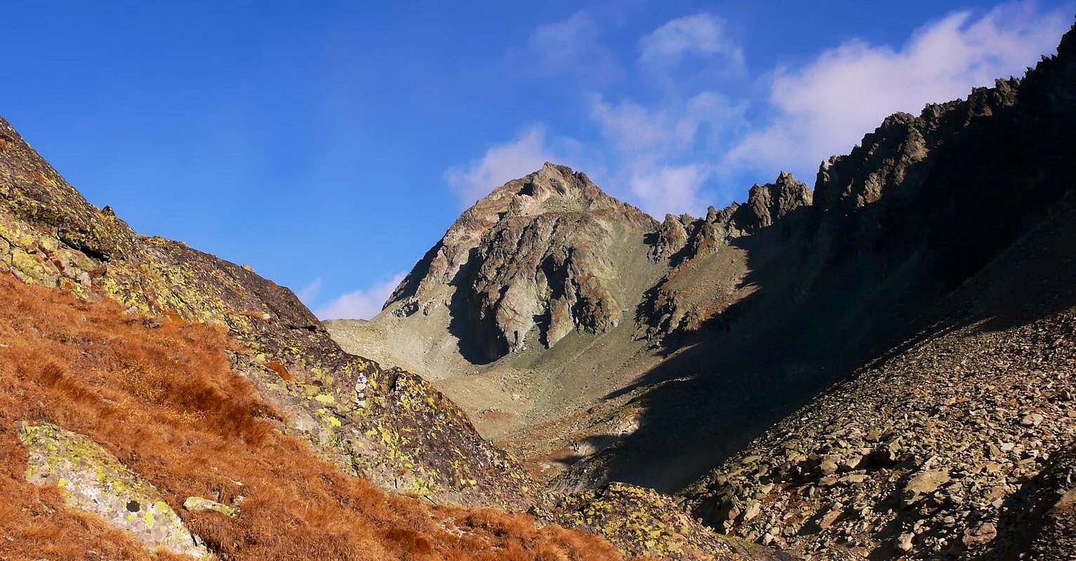
A slightly flattened pyramidal shaped mountain, fine to see from SE (Comba di Vertsan), much less from Comb of Crete Sèche. Placed between the Passes Berlon (3.009m) and della Sabbla (2.900m), toward S it has huge and steep rocky banks. Fine panorama on Mont Gelè and Becca di Chardoney.
Montagna a forma di piramide leggermente depressa; possiede un certo fascino se vista da SE dalla Comba Vertsan, mentre risalta meno dalla Comba di Crete Sèche. Sita tra i Colli Berlon (3.009 m) e della Sabbla (2.900 m), presenta poderose banconate molto ripide rivolte a mezzogiorno. Ottime le viste sul Mont Gelè e la Becca di Chardoney.
First Ascent
First on the summit (NW Slope): Abbè Joseph Henry, (Sep 04th, 1905).
In winter: Giuseppe Meneghello, Paolo Meneghello and Marco Pocchiola, (Mar 30th, 1968).
N-NE Arête: Abbè Joseph Henry, (Sep 04th, 1905), in descent.
S Arête: Osvaldo Cardellina, (Sep 10th, 1971), in descent.
Getting There
BY CAR:
From Torino, Milano, etc: Motorway A5. Exit at Aosta Est.
From Switzerland: through the Grand Saint Bernard Tunnel or the namesake pass.
From France: through the Mont Blanc Tunnel or Petit Saint Bernard Pass. It is not necessary to take Motorway A5: you can drive on SS.26, in the direction of Aosta.
BY PLANE:
Aeroporto "Corrado Gex" Saint Christophe (Aosta).
Itinerary
From highway toll of Aosta Est follow the SS.27 of Gran San Bernardo Tunnel, drive for about ten km and turn, to the right, toward Valpelline (964m), pass through it and follow for Oyace (1.377m). Once in Dzovenno (1.575m), turn to the left toward the small Village of Ruz (1.697m), park the car and start walking along a comfortable dirt road leading to the Baou de Bouque (2.129m) and to the Berrier Pastures (2.192m)1h'30.
Dall'uscita del Casello Autostradale di Aosta Est, proseguire sulla SS.27 in direzione del Tunnel del Gran San Bernardo; dopo circa un decina di chilometri svoltare sulla destra verso il Paese di Valpelline (964 m). Dopo averlo superato ed aver ignorato il bivio sulla sinistra che conduce a Ollomont (1.335 m) proseguire verso l'abitato di Oyace (1.377 m). Raggiunta la Frazione di Dzovenno (1.575 m), svoltare a sinistra verso il piccolo Villaggio di Ruz (1.697 m); qui posteggiare l'auto e iniziare la salita a piedi lungo la comoda strada poderale che conduce all'Alpeggio Baou de Bouque (2.129 m). Dopo averlo oltrepassato si raggiunge poco dopo l'Alpeggio di Berrier (2.192 m),1h'30.
Route
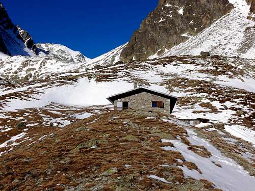
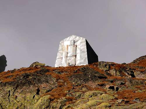
From Alpe Berrier (2.192m) a long and very panoramic crosswise path (fine spring at 2.242m) leads to Rifugio Crête Sèche (2.410m) and on up to the Bivacco Franco Spataro (2.600m). Follow toward the Plan de la Sabbla, an alluvial plain with many meanders; go up to a following plain known as Petit Plan and, leaving to the East a small lake (2.721m), turn to NE and along some narrow hairpins reach the Col de Crête Sèche (2.899m). Toward East, normally on snow, toward the foreland (2.917m) hosting a small lake and the following Plateu de Crête Sèche (big ending morain of the Glacier du Col de Chardoney); cross it with some ups and downs till the Col Berlon. Up, along the NW side, for about 150 meters on debris, getting the summit from its left side. (4h'00/5h'00).
Dall'Alpe Berrier (2.192 m) con un lungo diagonale molto panoramico (splendida sorgente 2.242 m) si raggiunge il Rifugio Crête Sèche (2.410 m); continuare a salire fino a Bivacco Franco Spataro (2.600 m). Proseguire in direzione del Plan de la Sabbla, spianata alluvionale con numerosi meandri; salire ad una successiva spianata conosciuta come Petit Plan e, lasciato a est un minuscolo laghetto (2.721 m), volgere a NE e su stretti tornanti pervenire al Col de Crête Sèche (2.899 m). Indirizzarsi su nevai a E verso il promontorio (2.917 m) con laghetto e successivo Plateu de Crête Sèche, grande morena basale del Glacier du Col de Chardoney; attraversalo con alcuni saliscendi sino al Col Berlon. Risalire il versante NW per circa 150 metri su detriti e sfasciumi uscendo appena a sinistra della vetta. (4h'00/5h'00).
FONDAZIONE MONTAGNA SICURA Villa Cameron, località Villard de la Palud n° 1 Courmayeur (AO) Tel: 39 0165 897602 - Fax: 39 0165 897647.
SOCIETA' DELLE GUIDE DELLA VALPELLINE Etroubles-Strada Nazionale, n° 13 - Tel +39 0165 78559 - Valpelline-Loc Capoluogo, n° 1 - Tel +39 0165 713502 (AO) Italia.
A.I.NE.VA. (Associazione Interregionale Neve e Valanghe).
Useful numbers
Protezione Civile Valdostana località Aeroporto n° 7/A Saint Christophe (Ao) Tel. 0165-238222.
Bollettino Meteo (weather info) Tel. 0165-44113.
Unità Operativa di Soccorso Sanitario Tel. 118.
Acknowledgements
I am greatly indebted to my friend "Osva" for the detailed description of the route. In addition i want to thank Gabriele Roth for the translation of the text from italian.
Parents refers to a larger category under which an object falls. For example, theAconcagua mountain page has the 'Aconcagua Group' and the 'Seven Summits' asparents and is a parent itself to many routes, photos, and Trip Reports.

 6161 Hits
 87.31% Score
 24 Votes