
-
 7052 Hits
-
 81.18% Score
-
 13 Votes
|
|
Mountain/Rock |
|---|---|
|
|
45.47170°N / 7.11245°E |
|
|
10948 ft / 3337 m |
|
|
Overview
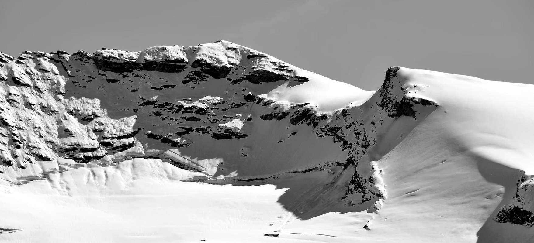
Mountain that belongs to the triptych Punta Basei (3.338m to North), Punta Bousson (3.337m Central) and Punta Galisia (3.346m to South). Present two slopes: glacial in Northwest and rocky in Southeast, with two fairly interesting routes; that's so one icy (short) and other rocky (long but with bad rock). Hardly ever sole aim, generally reached, rarely, through traverse from Basei Point also, quite frequently, coupling the ascent with more high and more renowned Galisia Point also called Galisia Point. Good ski-mountaineering excursion through the Eastern Fond Glacier, in old times Western Lavassey named. Excellent panoramic point to Great Paradise Mountain Chain in Northeast, on the whole Rhêmes Valley high head with splendid quick glance to nearby Tsanteleina Point (3.601m) and Granta Parei (=Great Wall; 3.387m).
Montagna facente parte del trittico Punta Basei (3.338 m a Nord), Punta Bousson (3.337 m Centrale) e Punta Galisia (3.346 m a Sud). Glaciale sul Versante Nord-Ovest, rocciosa su quello Sud-Est, sulle quali presenta rispettivamente due vie, perlappunto una in ghiaccio (breve) ed una in roccia (lunga ma con roccia non delle migliori), abbastanza interessanti. Quasi mai meta di per sé, é generalmente raggiunta, raramente, in traversata dalla Punta Basei ed, abbastanza frequentemente, abbinandola alla salita della più alta Punta Galisia o di Galisia. Buona gita sci-alpinistica attraverso il Ghiacciaio Orientale di Fond, una volta denominato Ghiacciaio Occidentale di Lavassey. Ottimo punto panoramico sul Massiccio del Gran Paradiso verso NE, su tutta l'alta testata della Valle di Rhêmes con bei colpi d'occhio sulle vicine Tsanteleina (3.601 m) e Granta Parei (3.387 m).
Getting There
BY CAR:
- From France: through the Mont Blanc Tunnel or the Col du Petit Saint Bernard: you can drive on SS.26, following directions for Aosta and, before arriving in Villeneuve, turn right towards Introd. Alternatively, you can take Motorway A5 (at Courmayeur or Morgex) and exit at Aosta Ovest.
- From all the other directions: get to the Aosta Ovest exit of Motorway A5. Then drive on SS.26 Aosta, in the direction of Courmayeur; just after Villeneuve turn left towards Introd.
BY PLANE:
- Aeroporto "Corrado Gex" Saint Christophe (Aosta).
Enter the valley and, at the fork between Valsavarenche and Val di Rhêmes turn to the right (Rhêmes). Cross all the villages to arrive to Rhêmes Notre Dame and follow to Thumel (car parking), herefrom, following the dirt road on the right side (ascending) of the valley, or, better with snow, a track on the left that passing throught some fine woods leads you to the Rifugio Benevolo (2.285m)
First Ascents
- First on the Summit: Giovanni Bobba and of Rhêmes mountain' guide Casimire Thérisod, (Aug 16th, 1888).
- W Slope of "Carving" 3.196m and NE Edge): Osvaldo Cardellina, Roberto Cremonese and Domenico Demichelis, (Oct 04th, 1986), in ascent and in day from Thumel.
- NE Ridge (from Basei Point): Giovanni Bobba and of Rhêmes mountain's guide Casimire Thérisod, (Aug 16th, 1888), in ascent.
- SE Eperon: Giovanni Bobba, Luigi Cibrario, Luigi Vaccarone and of Rhêmes mountain guide Casimire Thérisod, (Aug 15th, 1890), in ascent.
- SE Face (Direct Route): Enrico Marta and Giorgio Viale, (Aug 02th, 1970), in ascent.
- SW Crest: Giovanni Bobba and of Rhêmes mountain guide Casimire Thérisod, (Aug 16th, 1888), in descent.
- W-SW Slope (Ski-Mountaineering Route): Unknown or Giovanni Bobba and of Rhêmes mountain guide Casimire Thérisod, (Aug 16th, 1888), in descent.
- N Slope of W Shoulder and W-NW Slope (Standard Route): Unknown also Giovanni Bobba and of Rhêmes mountain guide Casimire Thérisod, (Aug 16th, 1888), in descent.
- N Wall Right Route and N-NW Ridge): Osvaldo Cardellina, Emilio Bertona, Nicola Colajanni and Gianfranco Vicentini, (Aug 22th, 2000), in ascent, in descent and in day.
- N Wall (Direct Route, after descent Basei Point W Face): Osvaldo Cardellina and Giuseppe Lamazzi, (Jul 21th, 1974), in ascent and in day.
- Great Traverse from Lavassey Point, Paletta N and S Points, Grand Vaudala and Little Vaudala Points, Nivoletta N and S Points, Quota 3.163m, Basei Point to Bousson Point: Osvaldo Cardellina and Giuseppe Lamazzi, (Jul 21th, 1974), crossing in day.
Approach to Gian Federico Benevolo Refuge
Approach to Gian Federico Benevolo Refuge: from Parking 1.848m continue in South through the road towards Pasture 1.901m and, leaving left that descending to of Thumel little Village 1.879m; worthy of visit with the tiny bridge nearby a deep gorge) and, by path n° 13, direct one's steps through Great Vaudala(z) Valley (foreground with beautiful waterfall). On the contrary near the pasture start the path n° 13 to Gian Federico Benevolo Refuge (2.285m; abounding signs); crossing below the characteristic small Church 1.936m, go up by South-southwest direction along and from upper the Rhêmes Stream; leaving right the deviation to Fos Alp, cross into a small valley the, with same name, small torrent reaching, by more in Southwest route amongst prairies, the Saint-Pantaleon (2.010m) and Barmaverain (2.037m) Pastures. Very soon wade across the torrent reaching "Cascate Area" (= Waterfalls; 2.051m); by a brief and hardly more steep ascent diagonal, go upper dirt main road and through false level route join at Roman Bridge upon the torrent (2.125/30m~). From this point continue by same road with two narrow hairpin bends to Lavassey Alp (2.227m) also to rejoin by a short cut, at once over the bridge; from pasture by short cut again or by a nearby dirt road reach the refuge, sited on ample grassy-rocky promontory (E; 1h'15/1h'30).
Dal Parcheggio 1.848 m continuare verso S tramite la strada verso l'Alpeggio 1.901 m e lasciando sulla sinistra quella che brevemente scende al piccolo Villaggio di Thumel (1.879 m; merita una visita insieme al vicino ponticello sito presso una profonda gola) e con sentiero n° 13 si indirizza verso il Vallone della Grand Vaudala(z) (bella cascata frontalmente). Presso l'alpeggio si diparte invece il sentiero n° 13 per il Rifugio Gian Federico Benevolo (2.285 m; abbondanti segnalazioni), che, passando sotto la caratteristica Chiesetta 1.936 m, si indirizza verso S-SW seguendo dall'alto il corso della Dora di Rhêmes; lasciando sulla destra (W) la diramazione per l'Alpe di Fos, oltrepassare in un valloncello l'omonimo torrente raggiungendo, con percorso più a SW tra le praterie, gli Alpeggi di Saint-Pantaleon (2.010 m) e di Barmaverain (2.037 m). Subito dopo guadarne il torrente raggiungendo la località "Cascate" (2.051 m); con un breve diagonale, appena più ripido, e portarsi sulla soprastante strada sterrata poderale e, con percorso in falsopiano, pervenire al Ponte Romano sul torrente (2.125/30 m~). Da questo punto o continuare sulla stessa che con due stretti tornanti sale all'Alpe Lavassey (2.227 m), oppure raggiungerla tramite una breve scorciatoia subito sopra il ponte; dall'alpeggio ancora per scorciatoia, o lungo la vicina poderale, raggiungere il rifugio, sito in un ampio promontorio erboso-roccioso (E; 1h'15/1h'30).
Approachs to various Routes
A) - to Basei Pass or Lavassey Glacier: from Benevolo Refuge by South-southeast direction and path n° 13b cross false level route and along Eastern shore of Rhêmes Doire Stream towards Desot (= Lower) Basei Pasture (2.309m); leaving left (East) the path unsigned to Higher Basei Alp (2.412m), continue, same direction, crossing quotas 2.393m, 2.428m; from this point in South reach over the of torrent sources, in quota 2.400m and subsequent 2.429m. After brief route, change again direction in Southeast and cross on three small torrents near a tiny lake 2.480m~; go up passing other three little torrents reaching a narrowing between quotas 2.567m in left (Northwest) and 2.688m right (Southeast). In South again, passing other four small torrents, towards quota 2.707m at Lavassey Glacier lateral right moraine. Changing decisively in Southeast and go up in edge, by morenical little path always n°13b towards Nivoletta (Northeast)and Basei (East) Pass, in quota 3.000m~ (E; 2h'00/2h'30).
A) - verso il Col Basei o il Ghiacciaio di Lavassey: dal Rifugio Gian Federico Benevolo salire con moderata pendenza in falsopiano e con direzione S-SE (sentiero segnalato n° 13b) e lungo la sponda Orientale della Dora di Rhêmes raggiungendo l'Alpe Basei Desot (2.309 m); lasciando sulla sinistra (E) il sentiero per l'Alpe Basei Damon (2.412 m), continuare, stessa direzione, attraversando le quote (2.393 m, 2.428 m) Da questo punto e verso S risalire verso la quota 2.400 m sovrastante le sorgenti del torrente, nonché la successiva 2.429 m; dopo breve tratto, cambiare ancora direzione verso SE ed attraversare altri tre torrentelli, vicini ad un minuscolo lago 2.480 m~. Salire oltrepassandone altri tre raggiungendo una specie di strettoia tra le quote 2.567 m a NW e 2.688 m a SE; ancora nuovamente verso S, guadando altri quattro rivi, in direzione della quota 2.707 m all'inizio della morena laterale destra del Ghiacciaio di Lavassey. Cambiando per l'ultima volta rotta a SE salire sull'orlo della stessa con l'esile sentiero n° 13b verso i Colli di Nivoletta (N) e Basei (E), a quota 3.000 m~ (E; 2h'00/2h'30).
B) - to Eastern Fond Lake and Fond Glacier: from deviation 2.707m, leaving left theb path n° 13b towards Nivoletta and Basei Pass, continue in South-southwest to Fond Lake, enclosed between quota 2.650m, 2.672m; crossing at Lavassey Glacier morenic base (in off season or in winter snowfields extant). Crossing a various small torrents from this descending, reach a moraine only the same. Doubling left (Southeast) the Point Bousson W-NW Crest, caracteristic for its yellowish gendarmes, reach basic part of Fond Glacier, in old times Western Lavassey Glacier, at 2.800m (E; 2h'00/2h'15).
B)- verso il Lago ed il Ghiacciaio Orientale di Fond: dalla deviazione 2.707 m, abbandonando a sinistra il sentiero n° 13b per i Colli di Nivoletta e Basei, proseguire verso S-SW in direzione del Lac de Fond, racchiuso tra le quote2.650 m, 2.672 m; attraversando sotto le morene basali del Ghiacciaio di Lavassey (in bassa stagione od in inverno nevai), scavalcare varii torrentelli dallo stesso discendenti passando appena sopra lo stesso lago. Doppiare a sinistra (SE) la cresta W-NW della Punta Bousson, caratteristica per i suoi gendarmi giallastri, raggiungedo tra quota 2.781 m e quota 2.832 m la parte basale del Glacier de Fond, anticamente Glacier Occidental de Lavassey, verso i 2.800 m (E; 2h'00/2h'15).
 |
 |
 |
 |
 |
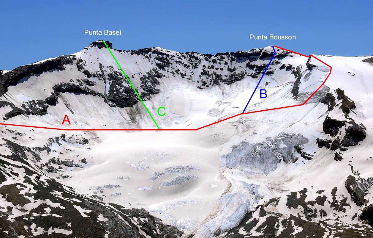
From Rhêmes Valley seven Routes Description
Route A - (NE Edge from Basei Pass and crossing of Basei Point): from deviation 2.707m in left (Southeast)through Galisia Point Route go up by path n° 13b along the moraine as far as upper crossroads towards Nivoletta (Northeast) and Basei (East) Pass, in quota 3.000m~, reaching, by a more steep terminal part, the last (3.176m; E; 2h'30/3h'00). Briefly go down along the SE Ridge passing two round "humps" with roughness (easy but exposed and more dangerous summital snowy frames extant, generally to East or Valsavarenche Valley) to Saddle/Carving 3.196m; continue false level route in quota by Bousson Point NE Edge doubling in right various pinnacles and narrow carving (the mayor to Rhêmes Slope or West), also crossing in edge (II°+, even III°-; no good rock). By a short final part, snowy often, more steep but more easy to Summit (PD/PD+; 1h'00/2h'00, according to snowy corniches conditions; impossible route sometimes, such as on the end of July 1974, forcing to descent by Basei W Wall for to go on with Bousson Point. 4h'00/4h'30 from refuge).Via A - (Cresta NE con traversata della Punta Basei dal Col Basei ): dalla deviazione 2.707 m a SE, con la via della Punta Galisia, risalire con il sentiero n° 13b lungo la morena sino alla soprastante biforcazione a 3.000 m~ per i Colli di Nivoletta (NE) e Basei (E) raggiungendo con un parte finale più ripida questo ultimo (3.176 m; E; 2h'30/3h'00); risalire alla Punta Basei per la Cresta N o via normale (3.338 m; EE/A; 0h'45/1h'00). Scendere brevemente lungo la cresta SW superando due dossi arrotondati con asperità (facile ma esposta e molto pericolosa in caso di cornici sommitali, generalmente rivolte ad E o Valsavarenche) alla Sella/Intaglio 3.196 m, per poi procedere in quota sulla Cresta NE della Bousson aggirando diversi pinnacoli ed intagli (i più importanti sul versante Rhêmes o W), oppure scavalcandoli sul filo (II°+, anche III°-; roccia non buona); con un breve tratto finale, spesso nevoso, più ripido ma anche più facile raggiungere la Cima (PD/PD+; 1h'00/2h'00, secondo le condizioni nevose; a volte impercorribile, come nel fine Luglio 1974, costringendo alla discesa della Parete W per poter proseguire verso la Punta Bousson. 4h'00/4h'30 dal Benevolo).
Route B - (W Slope of "Carving" 3.196m and NE Edge): by same Route A and half semicircular route on Lavassey Glacier below the Basei Point W Wall (rocks fallings possibility) to quota 3.050m~, at of Saddle/Carving 3.196m base; climb in W Slope, before by a short right diagonal, after vertically to narrow saddle trough snowy steep slope (37°, even 40°), with friables and broken rocks, appeared on the surface. Finish by rocky, generally snowy, edge to Summit, all the same route A (PD-; 1h'15/1h'30 from base with good conditions; dangerous after recent snowfalls; 3h'30/3h'45 from Benevolo).
Via B: - (Versante W dell'Intaglio 3.196 m e Cresta NE): con metà del percorso a semicerchio sul Ghiacciaio di Lavassey passando sotto la parete W della Punta Basei (possibilità di caduta di pietre) portarsi verso quota 3.050 m~, alla base della Sella/Intaglio 3.196 m; risalirne il Versante W dapprima con un corto diagonale sulla destra, quindi verticalmente allo stretto intaglio su ripido pendio glaciale (37°, anche 40°) con affioramenti di roccette friabili e rotte. Raggiunto l'orlo di cresta continuare verso la Vetta come per la Via A (PD-; 1h'15/1h'30 dalla base se in buone condizioni; da evitarsi dopo recenti nevicate per pericolo di slavine; complessivamente 3h'30/3h'45 dal Rifugio Benevolo).
Route C - (N-NW Wall Direct Route): same itinerary of the Route B until hundred/hundredtwenty~ meters from the terminal crevasses the W Great Shoulder (3.276m); to surpass it in semicircular manner (by short diagonal right/left ascent upon a very narrow snowy bridge, also in opposite more in left by an other very narrow and year in year a lot variable; at present more complex anbd more complicated, for mayor width and opening; besides a difference "brims" motive. See photographs from Basei Summit, on July 1980) heaiming directly to the peak on the glacial NW Wall with progressive slope (37°/40°/45°), leaving left (East) a few rocky bands (in old times formed by small rocks on the surface; nowadays considerable possibility ice in existence in triangular terminal narrowing) By icy final part, more easily to Summit (PD/AD-; 1h'00/1h'30 from bergsrunde, but a long variable time, snowy condition extant; 3h'30/4h'00 from Benevolo Refuge; 5h'00/6h'00 in day from Thumel Village).
Via C - (Parete N-NW, Via Diretta): con lo stesso percorso della Via B sino a 100/120~ metri dalla crepaccia terminale dello Spallone Ovest (3.276 m). Superare la stessa bergsrunde semicircolare (oggi molto più complessa di 30/40 anni fa, perché più aperta e con un labbro sfalsato dall'altro; vedi fotografie del Luglio 1980 dalla sommità della Basei), tramite un esiguo ponte di neve con andamento destra/sinistra, oppure più a sinistra con andamento rovescio (E; molto variabile a seconda delle annate), puntando direttamente alla Vetta sulla Parete glaciale N-NW con pendenza in progressivo aumento (37°/40°/45°). Lasciare ad E alcune fasce rocciose (una volta roccette emergenti; oggi notevoli possibilità di trovare ghiaccio vivo nella strettoia triangolare finale) nel tratto terminale, più dolce e facile nell'ultimo tratto (PD/AD-; 1h'00/1h'30 dalla crepaccia terminale, ma molto variabile a seconda delle condizioni; in totale 3h'30/4h'00 dal Rifugio Gian Federico Benevolo; 5h'00/6h'00 in giornata da Thumel).
Route D - (N Wall Right Route and N-NW Ridge): by preceding face and samr Route C cross right (W) about 40/50~ meters at terminal crevasse, here seemingly more large and safe; "board" and overcome with necessary cautions moving at begin of glacial slope. By a few in left (East) diagonal go beyond before a on the surface of ice small rocks; after vertical climb to two rocky bands, between passing through a brief right (W) diagonal and exit out by a short and longitudinal rocky strip. Reach this way the snowy higher tableland and go up entirely contra a steep rocky fall, doubling right possibility; from this by hemicircular left (East) route by degrees reach the N-NW Ridge and through same to Summit (Same time and considerations of Route C; estimate 0h'15/0h'30 not so much).
Via D - (Parete N-NW, Via di Destra e Cresta N-NW): oltrepassare di 40/50 metri~ la Route C portandosi alla crepaccia terminale 40/50 metri più a destra (W), qui apparentemente più larga e sicura; abbordala e passarla con le precauzioni dovute portandosi all'inizio del pendio glaciale. Con un diagonale leggermente a sinistra (E) passare dapprima verso una serie di roccette affioranti dal ghiaccio; successivamente salire in verticale verso due fasce rocciose, passandole in mezzo con un breve diagonale risalente a destra (W), fuoriuscendone superando una corta e longitudinale ulteriore fascia rocciosa. Toccare così il "plateau" superiore risalendolo interamente sin contro un ripido saltino roccioso doppiabile a destra; da questo punto con percorso semicircolare a sinistra (E) raggiungere gradualmente la Cresta N-NW e con questa concludere in Vetta (Stesso tempo e considerazioni della Route C; calcolare 0h'15/0h'30 in meno).
 |
Route E - (N Slope of W Shoulder 3.276m and W-NW Slope or Standard Route through Lavassey and Eastern Fond Glaciers): from the Gian Federico Benevolo Refuge to follow towards South the path n° 13b that conducts to the Nivoletta and Basei Pass, to leave to the left the trace of this last and to go down of few (20/30m~) reaching in the Glacier of Lavassey. To coast along him/it to And under the wall W of the Punta Basei and to reach the terminal crevasses of the Bousson Point W Great Shoulder (Absolutely no cross centre into glacier; collapse snowy bridge great danger on of crevasses web. On October 1986, returning from Summit, in doubt for cut short the route avoiding the more large tour contra the Basei Point, immediately reply: a terrible cannon shot and following great cave at least diameter about 10 meters into centre of glacier!). To go up again I pour him/it and actually to the quota 3.276m, passing approximately half route between the same and three characteristic Yellowy Jags (3.141m), from where for wide and easy crest, also more in right through large icy W-NW Slope, the peak is earned (3h'30/4h'00 from Benevolo Refuge).
Via E - (Versante NW dello Spallone W 3.276 m e Versante W-NW o Via Normale per i Ghiacciai di Lavassey ed Orientale di Fond): dal Rifugio Benevolo (2.285 m) seguire verso S il sentiero n° 13b ad E della Dora di Rhêmes che conduce ai Colli di Nivoletta e Basei; lasciare a sinistra la traccia di questo ultimo e scendere di poco (20/30 metri~) raggiungendo il Ghiacciaio di Lavassey. Costeggiarlo ad E sotto la Parete W della Punta Basei (crepacci!) e raggiungere la crepaccia terminale del Grande Spallone W della Punta Bousson (Assolutamente non attraversarlo; grande pericolo di crollo nella ragnatela di crepacci, soprattutto nel centro del ghiacciaio. Nell'Ottobre del 1986, in discesa nel dubbio di rifare il giro un pò più lungo sotto la Basei, abbiamo avuto una immediata risposta: una grande cannonata ed una voragine di almeno 10 metri di diametro improvvisamente apertasi proprio nel mezzo dello stesso!). Risalirlo (35°/40°) verso E (spesso verglass) sino alla quota 3.276 m, transitando a circa metà strada tra la stessa ed il caratteristico e triplice Dente Giallognolo (3.141 m), donde per larga e facile cresta, oppure più a destra sull'aperto pendio glaciale W-NW, si guadagna la vetta (3h'30/4h'00 dal Rifugio Benevolo).
Route F - (SW Crest from Saddle/Shoulder 3.300m~ or Bousson Pass also from Galisia Point): reached the large Saddle/Shoulder 3.300m~, also Bousson Pass with name, by Route E and between the Galisia and Bousson Points, turn left (Northeast) easily gaingin, by a brief SW Ridge, the Summit. Equally crossing from Galisia Point (3.346m), after ascent through any route (EE/A; F; 0h'15).
Via F - (Cresta SW dalla Sella/Spalla 3.300 m~ o Colle Bousson oppure dalla Punta Galisia): raggiunta la larga Sella/Spallone 3.300 m~, o Colle Bousson, tra la Punta Galisia e la Punta Bousson con l'itinerario E, svoltare a sinistra (N-NE) e pervenire facilmente, tramite la breve Cresta SW, alla Vetta, senza incontrare particolari difficoltà. Ugualmente provenendo dalla Punta Galisia (3.346 m), raggiunta per qualsivoglia via (EE/A; F; 0h'15).
Route G - (W-NW Slope also Ski-Mountaineering Route through the Eastern Fond Glacier): from deviation 2.707m and by approach B go up to of Fond Glacier base; in East completely climb, preferably contra Point Bousson W-NW Crest (be careful: from Great Shoulder 2.707m , more in South, blocks falls also snowslides possibility; see the pictures). Completely going the W-NW Slope, no disregard crevasses in existence and reach the Bousson Pass and following SW Crest (EE/A; 1h'30/2h'00; by ski-mountaineering necessary conditions of snow completely transformed; in total from Gian Federico Benevolo Refuge 4h'00/4h'30).
Via G - (Versante W-NW o Via Sci-Alpinistica per il Glacier de Fond Orientale): dalla deviazione 2.707 m e con l'avvicinamento B portarsi alla base del Glacier de Fond; risalirlo completamente verso E, tenendosi principalmente contro la Cresta W-NW della Punta Bousson (attenzione a non transitare troppo a S, poiché dallo Spallone 3.276 m esiste la possibilità di caduta di blocchi di roccia o slavine; guardare le fotografie). Risalire totalmente il Versante W-NW, non trascurando la presenza di crepe, e raggiungere il Col Bousson e la seguente Cresta SW (EE/A; 1h'30/2h'00; in sci-alpinismo richieste condizioni di neve completamente trasformata; complessivamente dal rifugio 4h'00/4h'30).
DESCENTS: exclusively advised the Route E, by descent from Great Shoulder 3.276m and a more large tour on Lavassey Glacier before in East-northeast, after North contra Basei Point W Face, with of Route E same remarks and considerations. Alone by ski-mountaineering the Route G.
DISCESE: è consigliata esclusivamente la Via E, con discesa dallo Spallone 3.276 m e susseguente giro più largo sul Ghiacciaio di Lavassey prima verso E-NE, poi a N contro la Parete W di Punta Basei, con le stesse osservazioni e considerazioni di Route E. Solo per lo sci-alpinismo la Via G.
Difficulties
This route can be considered F/PD+.L'itinerario è classificato F/PD+.
Essential Gear
Mountaineering equipment, including rope, iceaxe, and crampons.Da alta montagna, corda, picozza e ramponi.
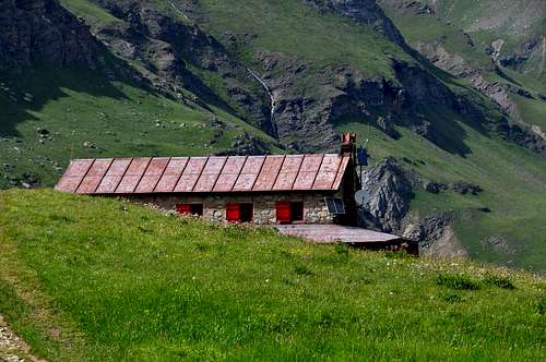
Huts
Rifugio GIAN FEDERICO BENEVOLO
 |
Red Tape
The Eastern side of the valley belongs to Gran Paradiso National park, the Western one is out of the boundaries of the Park ... but nature must be respected.Il lato orientale della valle appartiene al parco nazionale del Gran Paradiso, quello occidentale è fuori dai confini del Parco ... ma la natura deve essere rispettata.
Campings
Remember that free camping is forbidden (except for emergency reasons, over 2.500m, from darkness until dawn).Mountain Conditions
- You can get meteo information at the official site of the Regione Valle d'Aosta:
- Valle d'Aosta Meteo
- Meteo: You can find more weather information on the website 3B Meteo:
- Meteo Rhemes Notre Dame
Webcam
- WEBCAM on Aosta Valley:
- Webcam
Books and Maps
BOOKS:- "Guida delle Alpi Occidentali" di Giovanni Bobba e Luigi Vaccarone C.A.I. Sezione di Torino Volume II (parte II), 25 Maggio 1896.
- "Guida dei Monti d'Italia-Gran Paradiso Parco Nazionale" E. Andreis, R. Chabod, M. C. Santis, Club Alpino Italiano/Touring Club Italiano, prima Ed. 1939; seconda Ed. 1963; terza Ed.
- "Guida della Regione Autonoma Valle d'Aosta" di Mario Aldrovandi,Ed. S.P.E. di Carlo Fanton, Torino 31 Dicembre 1964.
- "Rifugi e bivacchi in Valle d'Aosta", di Cosimo Zappelli aggiornata da Pietro Giglio, Musumeci Editore, Luglio 2002.
- "Diari Alpinistici" di Osvaldo Cardellina e Indice Generale accompagnato da Schedario Relazioni Ascensioni 1964-2019 (inediti).
 |
 |
 |
 |
 |
MAPS:
- Kompass "Gran Paradiso Valle d'Aosta Sentieri e Rifugi" Carta Turistica 1:50.000.
- Enrico Editore Ivrea-Aosta "Gruppo del Gran Paradiso" 1:50.000.
- I.G.C. Istituto Geografico Centrale Torino "Valsavarenche Val di Rhemes Valgrisenche Parco Nazionale del Gran Paradiso", (carta n° 102), 1:25.000.
- I.G.C. Istituto Geografico Centrale Carta dei sentieri e dei rifugi "Il Parco Nazionale del Gran Paradiso" 1:5.0000.
 |
 |
 |
 |
Important Information
- REGIONE AUTONOMA VALLE D'AOSTA the official site.
- FONDAZIONE MONTAGNA SICURA Villa Cameron, località Villard de la Palud n° 1 Courmayeur (AO) Tel: 39 0165 897602 - Fax: 39 0165 897647.
- SOCIETA' GUIDE ALPINE DEL GRAN PARADISO Comune di Valsavarenche.
- A.I.NE.VA. (Associazione Interregionale Neve e Valanghe).
Useful numbers
- Protezione Civile Valdostana località Aeroporto n° 7/A Saint Christophe (Ao) Tel. 0165-238222.
- Bollettino Meteo (weather info) Tel. 0165-44113.
- Unità Operativa di Soccorso Sanitario Tel. 118.
Acknowledgements
I am greatly indebted to my friend "Osva" for the detailed description of all the texts and for the translation into English.