This PAGE is DEDICATED in MEMENTO of ILARIO ANTONIO GARZOTTO (* 1947 - † 1969) and GIANNI JUNOD (* 1948 - †1969) DEATHS in SE WALL (Arthur OTTOZ ROUTE) of AIGUILLE Jean Joseph CROUX (MONT BLANC GROUP), SEPTEMBER 29th, 1969 HOURS 9h.30~. Questa PAGINA é DEDICATA alla MEMORIA di ILARIO ANTONIO GARZOTTO (* 1947 - †1969) and GIANNI JUNOD (* 1948 - †1969) CADUTI sulla PARETE SE (VIA Arturo OTTOZ) dell'AIGUILLE Jean Joseph CROUX (MASSICCIO del MONTE BIANCO), 29 SETTEMBRE 1969 alle ORE 9.30~.
Ilario Antonio Garzotto
Gianni Junod
Overview
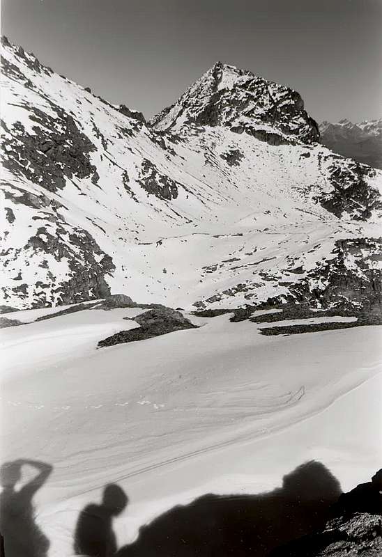
The Point Ilario Antonio Garzotto (3.273/4m) is the last to South of the group of the Roises on the crest watershed dividing the Walloon of Laures (to West) from the greatest and wide Valley of Saint Marcel to East. Small, irregular, pyramid with three crests and three walls, positioned immediately to North of the Hill of Leppe (3.110m), as well as of the homonym point (3.305m). From his top it departs toward North the small Subgroup of the yhree Roises (= from Roizà or Glacier, even if of these by now miserable traces have remained at the base of only the North Slope of Petite (Little) Roise, of the Wall W-NW of the Great one with the homonym placename and among the Point Garzotto and the Point of Leppe, of which last brings the name of it, all in acclaimed effect permafrost) in turn that it belongs to the GROUP of the Emilius Mountain (3.559m). The first quotation to this, small mountain, apparently finds it in "Guide of the Westerner Alps Vol. II. Graian and Pennine Parte Second" (1896), page 114, to work of Giovanni Bobba and Luigi Vaccarone: "Punte m 3.236 and 3.270. The first one is a beautiful pyramid of situated rock to south of the Hill of Leppe (p. 107); introduces him accessible with a scaling from the south. The other one rises to north of the motto pass and it is the extremity of the coastline of the Great Roise." The point 3.236m coincides with the Point of Leppe but with wrong quota (in effects 3.305/6m), while the second exactly locates our point, being wrong of very little in height. Formed by broken rock, as of however for all the points of the whole district, doesn't introduce great routes of rock, even if some sector still results to explore, as for instance the Wall N-NE, that would have however to present himself with rock of the same typology, or the E-NE Face, small but vertical, of Antesummit Northerner (3.230/5m about) as well as, more interesting, the East Wall of the homologous Oriental Great Shoulder (3.220/30m), to the appearance of compact rock and with almost vertical lines. Already slope also in winter, with a beautiful ski-mountaineering trip, as point of support departing from the Shelter Ernesto Ménabreaz to the Laures. through route to Leppe Hill and following ascent by the South Slope also Standard Route. On the other slope, or of Saint Marcel, points of support don't exist, since the Houses of Hunting to Mulac and to Great Chaux are of the Marquis Turati, while the alps are deprived and generally closed, if not in the stalls for the cows. For the qual thing, to less than not to get the permission, the departures I happen from immediately after the small Village of Tall Les Druges, near the Area Picnic, in a lower case parking lot to 2/3 places auto with relative poster of prohibition; therefore from this side a difficult, but rather long and fatiguing ascension looks out upon not him (even if beautiful and interesting, above all from the naturalistic point of view) with gone up again, in day, of the whole and long valley of the Reserve of the Marquis Turati, the Baron ex Reserve Beck end '800 Peckoz and in the first halves the following Century. In summit Cross positioning from nine muntaineers friendly and watch park of Turati Reserve Nature Osvaldo Pianfetti; Requiem (Mass) has been celebrated by the Reverend of Charvensod Paolo Papone, September 29th, 1994, in the occasion of the XXV° Anniversary of the death of the two boys.. Ilario Antonio GARZOTTO POINT (3.273/4m) from Southern, near the Pass and Mount Vallonet; from left West Face (outline), S-SW Ridge, South Slope (Standard Route) and Crest, East Crest, with the Great Shoulder 3.220/30m around
La Punta Ilario Antonio Garzotto (3.273/4 m)è l'ultima a Meridione del gruppo delle tre Roises sulla cresta spartiacque divisoria il Vallone delle Laures, ad Occidente, dalla più grande ed estesa Valle di Saint Marcel ad Oriente. Piccola piramide, irregolare, presenta tre creste e tre pareti; trovasi posizionata subito a Settentrione del Colle di Leppe (3.110 m), nonché dell'omonima punta (3.305 m). Dalla sua cima si diparte verso Settentrione il piccolo Sottogruppo delle Roises (= da Roizà o Ghiacciaio, anche se di questi ormai ne sono rimasti tre, solo con misere tracce alla base del Versante Nord della Petite Roise, della Parete O-NO della Grande con l'omonimo toponimo e tra la Punta Garzotto e la Punta di Leppe, della qual ultima ne porta il nome, tutti in conclamato effetto permafrost) a sua volta che fa parte dell'abbastanza esteso Gruppo del Monte Emilius (3.559 m). La prima citazione a questa, apparentemente, piccola montagna la riscontriamo in "Guida delle Alpi Occidentali Vol. II. Graie e Pennine Parte Seconda" (1896), pagina 114, ad opera di Giovanni Bobba e Luigi Vaccarone: "Punte m 3.236 e 3.270. La prima è una bella piramide di roccia collocata a sud del Colle di Leppe (p. 107); si presenta accessibile con una scalata dal sud. L'altra sorge a nord del detto valico ed è l'estremità della costiera della Grande Roise." La punta 3.236 m coincide con la Punta di Leppe, ma con quota erronea (in effetti 3.305/6 m), mentre la seconda localizza esattamente la nostra punta in questione, sbagliando di molto poco in altezza. Formata da roccia rotta, come d'altronde per tutte le punte dell'intero circondario, non presenta grandi vie di roccia, anche se qualche settore risulta ancora da esplorarsi come ad esempio la Parete N-NE, che dovrebbe però presentarsi con roccia della medesima tipologia, oppure la piccola ma verticale Parete E-NE dell'Antecima Nord (3.230/5 metri circa), nonché, più interessante, la Parete Est dell'omologo Gran Spallone Orientale (3.220/30 m), all'apparenza di roccia compatta e con tratti quasi verticali. Già salita anche in inverno, con una bella gita sci-alpinistica, partendo come punto di appoggio dal Rifugio Ernesto Ménabreaz alle Laures e con itinerario verso il Colle di Leppe. nonché Via Normale lungo il Versante Meridionale. Sull'altro versante, ovvero di Saint Marcel, non esistono punti di appoggio, poiché le Case di Caccia a Mulac ed a Grande Chaux sono del Marchese Turati, mentre gli alpeggi sono privati e generalmente chiusi, se non nelle stalle per le mucche. Per la qual cosa, a meno di non ottenere il permesso, le partenze avvengo da subito dopo il piccolo Villaggio di Les Druges Alte, nei pressi dell'Area PicNic, in un minuscolo parcheggio a 2/3 posti auto con relativo cartello di divieto; quindi da questo lato si prospetta un'ascensione non difficile, ma piuttosto lunga e faticosa (anche se bella ed interessante, soprattutto dal punto di vista naturalistico) con risalita, in giornata, dell'intero e lungo Vallone della Riserva del Marchese Turati, ex Riserva del Barone Beck Peckoz a fine dell'800 e nella prima metà del successivo Secolo. Nel posizionamento della Croce sulla Vetta, effettuato da un gruppo di nove alpinisti amici in compagnia dell guardiaparco Osvaldo Pianfetti, la Messa di Requiem è stata celebrata per l'occasione dal Reverendo di Charvensod Don Paolo Papone il 29 settembre 1994, nell'occasione del XXV° Anniversario della morte dei due ragazzi.
First Ascents
First on the Summit (partially): Agostino Ferrari and Mountain Carrier of Cogne B. Glarey, (Sep 15th, 1898), from Cogne, Leppe Pass and SW Slope discarding West the Top.
First on the Top: Giovan Battista Bozzino and Armando Bertucci, (Aug 12th, 1910), in ascent from Cogne, Leppe Pass and SW Slope, crossing to Gr./P.te Roise/Salé Pass.
In winter: Pietro Giglio Mountain Guide Aosta and Matteo Giglio, (Dec 28/29th, 1994), by ski from Ménabreaz Hut at Laures, West Slope Leppe Pass and S-SW Slope.
SW Slope (Normal Route): Agostino Ferrari and Mountain Carrier Cogne B. Glarey, (Sep 15th, 1898), from Les Laures Alp, West Slope of Leppe Pass and discarding West the Summit. Second and integrally up to the Summit: Giovan Battista Bozzino and Armando Bertucci, (Aug 12th, 1910), in ascent from Cogne through Leppe Pass.
SW Crest: Roberto Andrighetto, Guido Borettaz, Ruggero Busa, Osvaldo Cardellina, Sandrino Casalegno, Camillo Roberto Ferronato, Danilo Garzotto, Orlando Grivon with Don Paolo Papone and Gamekeeper Osvaldo Pianfetti (Sep 29th, 1994), in ascent from Grande Chaux and Leppe Pass. On the occasion of the positioning of the Cross.
S-SW Crest: Osvaldo Cardellina, solo (Oct 03th, 2011), in ascent from Grande Chaux, Fenêtre Vallon, Coronas Hill and before crossing Mont Vallonet, Col Vallonet, Punta di Lette to Leppe Pass; after through S-SW Crest with descent on SW Slope or Normal Route.
W Wall (Second rocky Rib of Left or Northern): Osvaldo Cardellina, solo (Aug 02th, 1998), in ascent from Ménabreaz Hut, Les Laures Long Lake, through Gr. Roise small Southern "Comba" and after a double first ascent to the Grande Roise through W-SW Ridge and on Southern Face.
W Wall (Central rocky Rib or Western Direct Route): Osvaldo Cardellina, solo (Oct 07th, 2011), in ascent from Les Druges Alte, Mulàc, Grande Chaux Alp, Fenêtre Vallon and Leppe Pass; in descent through the SW Slope or Normal Via to Leppe Hill to Grande Chaux Pasture, Layet Lake, Mulàc-St. Louis, Servette, Les Druges Alte.
W Wall (First rocky Rib of Left or North-northwestern): Osvaldo Cardellina, solo (Oct 21th, 2011), in ascent from Les Druges Alte, Mulàc, Fenêtre Vallon and Leppe Pass; in descent through the fourth rocky rib to Leppe Hill and subsequent traverse towards Punta di Leppe, Coll Vallonet, Mont Vallonet, Coronas Pass or of Saint Marcel Col to Grande Chaux.
W Wall (Fourth rocky Rib of Right or West-southwestern): Osvaldo Cardellina, solo (Oct 21th, 2011), in ascent on First rocky rib with descent through the Fourth rocky rib to Leppe Hill and subsequent traverse towards Punta di Leppe, Col Vallonet, Mont Vallonet, Coronas Pass or of Saint Marcel Col to Grande Chaux.
N Ridge: Agostino Ferrari and Mountain Carrier of Cogne B. Glarey, (Sep 15th, 1898), in descent to Grande and Petite Roise discarding West the Top. Integrally: Giovan Battista Bozzino and Armando Bertucci, (Aug 12th, 1910), in descent to Saddle 3.190 meters and in ascent with subsequent traverse to Punta di Leppe through NE Crest.
NE Face (Directly to Summit): Osvaldo Cardellina, solo (Jun 24th, 2005), in ascent from Les Druges/Grande Chaux/Crétonaz/Rualla Alps.
E-NE Edge (Shoulder about 3.220/30m): Osvaldo Cardellina, solo (Jun 19th, 2008), in ascent from Les Druges/Crétonaz/Rualla Alps.
E-NE Wall (Shoulder 3.220/30m) and E Ridge: Osvaldo Cardellina, solo (Apr 24th, 2005) in ascent from les Druges/Rualla Alp.
E Ridge (Shoulder 3.220/30m)): Gamekeeper Osvaldo Pianfetti, (between Eighties/Nineties), from Gr. Chaux Hunting House.
S-SE Face (Red Plates Via): Osvaldo Cardellina, Nicola Colajanni and Gianfranco Vicentini (this last exclusively Leppe Top), (Aug 21th, 1998), with crossing to Leppe Pass, Punta, Coronas Pass.
S Crest (integral): Osvaldo Cardellina and Danilo Garzotto, (Aug 13th, 2005), in ascent from Les Laures-Ménabreaz Shelter, Leppe Pass.
Getting There
BY CAR:
From Torino, Milano, etc: Motorway A5. Exit at Aosta Est.
From Switzerland: through the Grand Saint Bernard Tunnel or the namesake Pass. Drive to Aosta.
From France: through Mont Blanc Tunnel or Petit Saint Bernard Pass. It isn't necessary to take Motorway A5: you can drive on SS.26, in the direction of Aosta.
BY PLANE:
Aeroporto "Corrado Gex" Saint Christophe (Aosta).
Approaches toward the pass
From Saint Marcel and through the Pass of Leppe: from Tall Les Druges Village (1.567m; fountain and little beautiful wooden "rascard", nearby the same), place Pouria Alp (1.586m. after the "Les Druges Picnic Area) along the coincident earth road "poderale" with the path n° 3 that, passing through Vargney Pasture (1.676m; various iron and copper dumpings of mine) and doubling from West to South the terminal rocky-woody promontory of Mont Roux (2.277m), it forwards him in the long Walloon of Saint Marcel, that arrives to homonym hill before the Cogne Valley. (* RESERVEof Hunting Marquis Turati and the Baron ex Preserve Beck Peck(c)oz) passing under the abandoned coppermines of Servette, among the 1.720 meters and the 1.810 meters. Beautiful turn tourist-excursion through paths n° 15/16, as well as different small paths of connection between the entrance of the various mines and huts in stone of the miners, protected from cyclopic great boundaries and supporting walls, and remains of great cableways. Wanting to effect complete to turn reconnaissance with different departures and slightly crossed to slighty more elevated quota;
a) - from the area PicNic with diagonal path that cuts to half coast the Northern slopes of Mont Roux reaching her same, from which with brief descent he returns on the earth road;
b) - departing from the near of the Alp Pouria (place "garages" in to beautiful clearing of lawns with demolished pasture, just immediately under the road; present system of signs as soon as awry near the small torrent) and reaching the first one dark or lower part and old hand the miners installation, in downfall but with fireplace to standing wall still, for finally to connect him to the precedent itinerary. Besides possibility of prosecution and variation of excursion for the Alpe Lavanché (2.271m), with the path n° 18, along the forest, through the muletrack uses to the transport of the copper and iron minerals ones, with a characteristic passage on stony wall; from the same reenter to soil road through the small path n° 3 to crossroads 1836m, near Praborna Pasture (1.882m) and its manganesemine.
c) - With start after Vargney Alp (1.676m), through, always, path n° 18, crossing in parallel with a small brook of irrigation and inside a good and thick forest, reaching the previous routes. To continue South direction, crossing at the foots of Westerner Slope of Mount Roux traversing the its woods, to (** Hunting's House Turati of Mulac (1.937m; beautiful fountain and statuary steinbock, both in wood; entrance of mines, also them abandon, of manganese near Praborna Pasture (= Lawn of the Hole; 1.882m; rarities of the "violano", mineral existing in few places in the world; to enter with small deviation on road not numbered, over the alternative 1.836m and small final diagonal). From the aforesaid crossroads, where the path on the left (East) the deviation for the Alp Lavanché with numeration 3, to continue with the soil "poderale"-path n° 4; the same one, formed a great handle after the bridge in wood preceding the Sinsein Pasture (1.995m) and, through a steep line goes up again rather, after having forded two other secondary torrents, toward the Alps Dessous of Plan Ruè (2.100m and 2.129m). With an along rectilinear through the Plan of Emonin, to reach that of Dessus (2.205m). Slightly folding up more toward South-southwest to reach that of (*** Layet (little lake 2.233m); small loch as soon as above after a mean hairpin bend circle and nearby a rocky pomontory with memorial tablet; backup signaling of fishing). After having forded other three times of small ramifications, more to giving rise more under the Torrent de Saint Marcel, and, abandoning left the deviation in Southeast through the dirt road for (**** Petite Chaux Pasture (2.419m), ramification of the soil "poderale", before through a small path not numbered, after, just farther on fork 2474m with the intervalleys path n° 102 toward Lavodilec Hill (2.883m), sited between the Point of Tessonet (3.266m) and the Little Avert (2.947m) and permitting a good traverse to Val Fènis-Clavalité on the watershed between the two parallel splendid walloons, descending to Dora Baltea Stream). With a last East hairpin bend to reach the House of Hunting Turati to Great Chaux (2.370m; generally the gamekeeper presence), also this ex House of the Baron Beck Peck(c)oz. From this, abandoning toward South-southwest the path n° 4 addressed to the Hill of Saint Marcel or Corona or he also called Coronas (2.913m), to go up again toward Northwest through a small path not numbered; gone beyond a ruin (2.391m), to address him toward the small stream that comes down from the small walloon called "Gran Vallone". Left to the left this (West) to continue in diagonal thin to a rated promontory 2.483 meters. To continue toward West (***** Caution, on the right it continues a ramification "dead" that he brings under the quota 2.706 meters, to avoid and continue to left or West.) Left to the left this (West) to continue in diagonal thin to a rated promontory 2.483 meters. To continue toward West with the least evident path that, at times, a trace becomes; only with a ramp, amongst steep meadows, to reach a grassy tableland with various boulders to quota 2.891 meters. From these the path becomes only a trace and through terrestrial debris and with a last brief underlying left diagonal to the right to a rocky band easily to reach to the Pass of Leppe (3.110m; E; 3h'00/3h'30). Friendly group that carried the CROSS, with route from High Les Druges Village toward Great Chaux Hunting House (Saint Marcel Valley) and through the Great Vallon to Leppe Pass.
Da Saint Marcel e tramite il Colle di Leppe: da Les Druges Alta (1.567 m; fontanile e splendido piccolo "rascard" in legno appresso la medesima), località Pouria (1.586 m) lungo la poderale coincidente con il sentiero n° 3 che, doppiato il roccioso e boschivo promontorio terminale del Mont Roux (2.277 m), si inoltra nel lungo Vallone di Saint Marcel, che perviene sino all'omonimo colle a cavallo con la Valle di Cogne. ( * RISERVAdi Caccia Marchese Turati ed ex riserva del Barone Beck Peck(c)oz; passando al di sotto delle miniere abbandonate di rame di Servette tra i 1.720 metri ed i 1.810. Bel giro turistico-escursionistico tramite sentieri n° 15/16, nonché diversi sentierucoli di collegamento tra l'imbocco delle varie miniere, resti di grandi teleferiche e baracche in pietra dei minatori, protette da ciclopici muraglioni di cinta, nonché di sostegno. Volendo effettuare un giro perlustrativo più completo, con partenze diverse, ed attraversata a quota leggermente più elevata:
a) - dall'Area Pic Nic con sentiero diagonale, che taglia a mezzacosta i versanti Settentrionali del Mont Roux, raggiungendo le miniere stesse, dalle quali con breve discesa si ritorna sulla strada poderale;
b) - partendo dai pressi dell'Alpe Pouria (località "garages" in una bella radura prativa con alpe diroccata, subito sotto la strada; segnaletica presente appena a monte, presso il torrentello) e raggiungendo il primo o più basso e vecchio insediamento dei minatori, in rovina ma con camino a muro ancora in piedi, per infine ricollegarsi al precedente itinerario. Inoltre possibilità di prosecuzione per l'Alpe Lavanché (2.271 m) con sentiero n° 18, lungo la foresta per mezzo della mulattiera usa al traporto dei minerali del ferro e del rame, con un caratteristico passaggio su di un muraglione di pietra; dall'alpeggio rientrare sulla poderale per mezzo del sentierino n° 3 in direzione dell'incrocio 1.836 m, nei pressi dell'Alpe di Praborna (1.882 m) e della sua miniera di manganese.
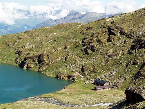
c) - Con avvio dalla poderale oltre l'Alpeggio di Vargney (1.676 m), tramite sentiero n° 18, parallelamente ad un ruscelletto d'irrigazione nel fitto della bella foresta e così pervenendo ai precedenti itinerari. pervenendo, passando ai piedi del versante Occidentale del Mont Roux ed attraversandone i suoi boschi, alla (** Casa di Caccia Turati a Mulac (1.937 m; bel fontanile e statuario stambecco, entrambi in legno); imbocco delle miniere, anch'esse abbandonate, di manganese a Praborna = Prato della Buca; 1.882 m; rarità del violano, minerale esistente in pochi posti nel mondo; per accedervi piccola deviazione su strada poderale non numerata, oltre il bivio 1.836 m e breve diagonale finale. Dall'incrocio predetto, ove il sentiero lasciata sulla sinistra (E) la deviazione per l'Alpe Lavanché tramite sentierino con numerazione 3, continuare con la strada poderale sentiero n° 4; la medesima, formata una grande ansa dopo il ponte in legno prededente l'Alpe di Sinsein (1.995 m), e, per mezzo di un tratto alquanto ripido, risale, dopo aver guadato due altri torrenti secondari, verso gli Alpeggi Dessous di Plan Ruè (2.100 m e 2.129 m). Con un lungo rettilineo, attraversando il Plan d'Emonin, raggiungere quella di Dessus (2.205 m). Piegando leggermente più verso S-SO arrivare a quella di (*** Layet (= Piccolo Lago)2.233 m); per l'appunto, laghetto appena sopra, subito dopo un tornante a mezzo cerchio che adduce ad un minuscolo promontorio roccioso con lapide; segnalazione di Riserva e relativo divieto di pesca). Dopo aver guadato altre tre volte delle piccole ramificazioni secondarie, originanti più in basso il Torrent de Saint Marcel, e, lasciata a SE la deviazione con strada poderale per (**** l'Alpe di Petite Chaux (2.419 m; ramificazione della strada poderale, poi segnalazioni con sentiero dapprima non numerato eppoi, da appena oltre il bivio 2.474 m con il sentiero intervallivo n°102 per il Colle di Lavodilec (2.883 m), posto a cavallo tra la Punta del Tessonet (3.266 m) a Meridione ed il Petit Avert (2.947 m) e permettente una bella traversata in Val Fènis-Clavalité sullo spartiacque tra le due splendide vallate parallele, che scendono verso la Dora Baltea), con un ultimo tornante ad E raggiungere la Casa di Caccia Turati a Grande Chaux (2.370 m; in genere presenza del guardiacaccia; anche questa ex Casa del Barone Peck(c)oz). Da questa, abbandonando verso S-SO il sentiero n° 4 indirizzato al Colle di Saint Marcel, oppure Corona od ancora Coronas (2.913 m), risalire verso NO con un sentierino non numerato; oltrepassato un rudere (2.391 m), indirizzarsi verso il torrentello che discende dal valloncello chiamato "Gran Vallone"; lasciato questo a sinistra (O), continuare in diagonale fino ad un promontorio semi roccioso quotato 2.483 m. (***** Attenzione, sulla destra continua una ramificazione "morta" portantesi sotto la quota 2.706 m, da evitare continuando invece verso sinistra od Ovest.) Procedere verso O per mezzo del sentiero meno evidente che, a tratti, diventa solo una piccola traccia; con una rampa, che attraversa ripidi prati, raggiungere un pianoro erboso con alcuni macigni sparsi a quota 2.891 m. Da questi il sentiero diventa solo una traccia e, attraverso terreno detritico e con un ultimo breve diagonale da sinistra a destra sottostante ad una fascia rocciosa, facilmente pervenire al Colle di Leppe (E; 3.110 m; 3h'00/3h'30.
From the Great Brissogne Commune (894m), toward to continue West along the road up to the poster of prohibition (here than from of becoming in before road in earth "the poderale"); from this point, turning in opposite sense, goes up again up to the Gremonenche Pasture (1.000m around). Always through the same one that from this point and through the path n° 1 it begins his entry in the really truth of Vallon of Laures parallely and overhanging the homonym torrent, to the Arp of it arrives of him (1.310m; the writing Larp on a wall of the mountain house). To continue of then, along a run that confining more next to the Laures Torrent, arrives in first succession to the La Vieille Pasture (1.623m) and therefore a that of Le Tramail also called The Tramouail, near a small prairie (1.951m; good shelter in case of bad meteorological conditions; always open and endowed with heater and provisioning). Crossing on a series of small bridges in stone and wood, they happen of him of what a pressing rhythm to the altitude of middly of 2.200/2.400 meters about, the torrent is forded in repeatedly the senses of march bringing himself due in a more open zone, dove the path becomes muletrack true of proper of and, draws of different of underlining they govern recent maintenance. DIRECT VARIATION:mostly starting from this point, precisly in quota 2.191 m (small stoneman), a steep run with the path n° 1A, fast more of but more than it addresses of him a right (West), toward the slant Oriental of the "Becca di Seneva", for directly to go up again of then at first long smoothed slabs and therefore they govern path, toward the entrance of access to the Laures Valley, where the walloon him "the throat". Forded the emissary of the Lower Loch through an wooden bridge, it rejoins of him of they govern us the final part of itinerary of they found, in quota 2.567m, nearby a fork (sees under); leaving completely on the left (East) the impending rocky promontory, to the peak of which he has been in 1930 builts the small Chapel (2.613m; slight of perennial signaling) in memory of the fallen ones on the East Wall of the Emilius. On the right (West-southwest) immediately before of th crossroads 2.567m, go up the path n° 8 that it goes up again to the Peckoz Pass (3.042m; easy and beautiful excursion that brings on the crest watershed among Les Laures and wild Valley of the Arpisson; good photographic perspectives on the East Walls and North and Black Triangle of the Emilius). Contrarily and in opposite sense or to East-southeast, and always from the crossroads 2.567m, it begins the path n° 6A that, gone beyond the aforesaid chapel, it continues to half coast, in aerial form, "cutting" the whole Northwesterner steep Slopes of the Pecks of Salé bringing itself, doubled to the basic on the Crest North the homonym Tower (3.073m), toward the Salé Cross (2.382m) and, after as easy brief down, to Bonplan Pasture (2.374m), in the Vallon of Arpisson-Saint Marcel (* not confused to himself with that of the Arpisson-Pollein "Vallone") (EE; 2h'00/3h'00). Sees under. BLACK FOUNTAINS ROUTE: steep Less, as well as fatiguing, toward of run of the and that it almost brings him until against the Wall of the "Becca of Salè" (2.314m; the this is known come to of the of Street Black Fountains, a causes of numerous rivulets of water that gush out and gushing they flow on blackish great blocks of grey gneiss and smoothed by the by now disappeared Glacier of Laures) and sale along the last 400 meters after twice changes of the direction in quota 2.492m, on wider slant up to the summit of a series of rocky terraces (2.600 around of the meter; on the promontory of little impending toward of and East, small chapel votive devoted to Jean and Alessandro "Dino" Charrey, the very young brothers, and Cino Norat, fallen then in 1929 on him virgin East Wall of the Emilius). Climbed over the wide saddle and they govern through a short and in left diagonal (Southeast), passing as soon as above the Laures Dessous Loch or Inferior, the of it reaches of I am Sheltered Ernesto Ménabreaz (2.542m; the privacy, but always open of free of and, also in winter; the heater (firewood of the to go himself, even if it is in endowment of it); the beds a castle for 8 places, covers and provisions they govern table, as well as chairs; EE; 3h'00/3h'30). From the Shelter to go himself with the path toward South, going beyond the homonym Alp; doubling it, on to minuscule promontory, on the left (East) to cross with sweet slope toward S crossing the whole Walloon of the Laures. Transiting from the Long Lake (2.630m); not very over and near alternative an (* to the right the paths depart for the Pass of the Laures and for the Pass of Arbolle) in to grassy tableland, at the edge of the moraine of Leppe, to decidedly change direction to East; through the same one, overcoming at first to steep line with rocks broken soil mixed followed by to morainic ridge, and then long comfortable snowfields and to small "giogaia" (= mountain range small basin), as soon as under to the footstep and the small glacier (apparently extinct) underlying the Point of Lussert (3.221m) and the Point of Leppe (3.305m) to go up again with to little evident traces, deposit and glacio-snowcapped to the Leppe Pass (3.110m) (EE/A; 2h'00/2h'30 from Ménabreaz Refuge). The "expedition" of friendly people to CROSS, with route from Les Laures Valley to Ménabreaz Refuge and toward Leppe Vallon and homonym little Glacier to Leppe Pass.
Dal Comune di Grand Brissogne (894 m), proseguire verso O lungo la strada insino al cartello di divieto (diventando da qui in avanti strada sterrata "poderale") ove questa, voltando in opposto senso, risale fino all'Alpeggio di Gremonenche (1.000 metri circa). Da qui, sempre tramite la stessa, che da questo punto inizia il suo ingresso nel Vallone vero e proprio delle Laures parallelamente e sovrastando l'omonimo torrente, si arriva all'Arp (1.310 m; scritta Larp su di un muro della baita). Poi continuare, lungo un percorso con sentiero n° 1 che, confinando più dappresso al Torrente des Laures, arriva in successione prima all'Alpeggio di La Vieille (1.623 m) e quindi a quello di Le Tramail o Le Tramouail, presso una piccola prateria (1.951 m; buon ricovero in caso di cambiamento del tempo, sempre aperto e con stufa e vettovagliamento). Attraversando su di una serie di ponticelli in legno e pietra, succedentisi a ritmo incalzante e mediamente all'altitudine di 2.200/2.400 m~, si guada ripetutamente il torrente portandosi in una zona più aperta, ove il sentiero si tramuta, con evidenti segni di recente manutenzione, in vera e propria mulattiera. VARIANTE DIRETTA:cominciando da questo punto, precisamente a quota 2.191 m (ometto in pietra, non sempre facilmente individuabile per chi non conosce bene la strada), un percorso tramite sentiero n° 1A maggiormente ripido, ma più veloce, si indirizza più a destra (W), verso i pendii Orientali della Becca di Seneva, per poi risalire direttamente, dapprima lungo lastroni levigati e quindi con un sentierucolo, verso l'imbocco d'accesso alle Laures, dove il vallone si "strozza", lasciando completamente sulla sinistra il soprastante promontorio roccioso, al culmine del quale é stata nel 1930 edificata la Cappelletta in memoria dei caduti sulla Parete Est dell'Emilius. Guadato l'emissario del lago tramite un piccolo ponte in legno, ci si ricongiunge in breve con la parte finale dell'itinerario di base, a quota 2.567 m, presso un incrocio (vedi sotto); lasciando completamente sulla sinistra (E) il soprastante promontorio roccioso, al culmine del quale é stata nel 1930 edificata la piccola Cappella (2.613 m; luce di segnalazione perennemente accesa) in memoria dei caduti sulla Parete Est dell'Emilius. Sulla destra (O-SO) e subito prima dell'incrocio 2.567 m, si diparte il sentiero n° 8 che risale al Col Peckoz (3.042 m; facile e bella escursione adducente sulla cresta spartiacque tra Les Laures ed il selvaggio Vallone dell'Arpisson; ottime prospettive fotografiche sulle Pareti Est e Nord e Triangolo Nero dell'Emilius). Al contrario sempre dal bivio 2.567 m ed in senso opposto, ovvero a E-SE, inizia il sentiero n° 6A che, oltrepassata la predetta cappella, prosegue a mezzacosta tagliando in maniera "aerea" tutto i ripidi Versanti Nordoccidentali della Becca di Salé portandosi, doppiata alla base sulla Cresta Nord l'omonima Torre (3.073 m), verso la Croix de Salé (2.382 m) e, dopo breve e facile discesa, all'Alpe di Bonplan (2.374 m), nel Vallone di Arpisson-Saint Marcel (da non confondersi con quello dell'Arpisson-Pollein) (EE; 2h'00/3h'00). Vedi appresso. VIA delle FONTANE NERE: meno ripido, nonché faticoso, il percorso verso levante che si porta fino quasi contro la Parete O della Becca di Salè (2.314 m; questo è conosciuto come Via delle Fontane Nere, causa dei rivoletti d'acqua che sgorgano e zampillando scorrono copiosi su grandi blocchi in gneiss grigio nerastri e levigati dall'ormai scomparso Ghiacciaio delle Laures) e sale, dopo aver variato due volte direzione a quota 2.492 m, lungo gli ultimi 400 metri su pendii più ariosi fino al colmo di una serie di terrazzamenti rocciosi (2.600 metri circa; sul promontorio, di poco soprastante e verso Est, piccola cappella votiva dedicata ai fratelli Jean e Dino Charrey ed a Cino Norat, precipitati giovanissimi nel 1929 sull'allora inviolata Parete Est dell'Emilius). Scavalcata la larga sella e con una breve discesa in diagonale a sinistra (Sudest), passando appena sopra il Lago Dessous od Inferiore delle Laures, si raggiunge il Rifugio Ernesto Ménabreaz (2.542 m; privato, ma sempre e gratuitamente aperto, anche in inverno; stufa (portarsi la legna, anche se ve ne è in dotazione); letti a castello per 8 posti, coperte e vettovaglie con tavolo, nonché sedie; EE; 3h'00/3h'30). Dal Rifugio dirigersi con il sentiero verso Meridione, oltrepassando l'omonima Alpe; doppiandola, su di un minuscolo promontorio, sulla sinistra (Est) attraversare con dolce salita verso S percorrendo l'intero Vallone delle Laures. Transitando dal Lago Lungo (2.630 m); non molto oltre e presso un bivio (* a destra partono i sentieri per il Colle delle Laures e per il Colle d'Arbolle) in un pianoro erboso, ai confini della morena di Leppe, cambiare direzione decisamente ad E; tramite la stessa, superando dapprima un tratto ripido con rocce rotte frammiste a terriccio seguito da un crinale morenico, e poi lungo comodi nevai ed una piccola giogaia, appena sotto al passo, ed il piccolo ghiacciaio (apparentemente estinto) sottostanti la Punta di Lussert (3.221 m) e la Punta di Leppe (3.305 m) risalire con tracce poco evidenti, detrito e glacio nevati al Colle di Leppe (3.110 m) (EE/A; 2h'00/2h'30 dal Rifugio Ménabreaz).
Route
From the Hill of Leppe to follow on small and less and less marked along the South Slope and to half road among the South Crest to the right (East) and that I S-SW; therefore to climb through broken rocks, at first on the vertical one, and then supporting to the right slightly through always broken and cheap rocks, holding to the left himself (West) of the thread of crest, (I°/I°+, attention to the fall of stones!). After leaving right a beautiful and solid "gendarme" with red rock and characterized with a large crack-chimney, to reach so a band of tilted rocks always reddish and mostly compact, with inclination to South; always revolving it on the left, to "reenter" then toward right thin to a small shoulder, with narrow carving on the South Crest. From this, leaving itself above the prosecution of the same one, that with about forty scarce meters and with run rather aerial and statement, but not difficult, it reaches the Peak (sees under "Variation"), to continue with a diagonal ascendancy formed by very broken rocks with debris and still soil, as soon as below the thread of South Crest. To finish reaching the Crest North near a steep correct rock behind the turret "summital", that wanders to West, overcoming a little dihedral a few meters; or, just before to reach to this, to exploit to right a final small rocky channel, of a dozen of meters (II°-) and to touch the Cross, posts on a small balcony of the Summit Southeast (1h'00/1h'15, from the Pass of Leppe; 4h'00/4h'30 altogether). FINAL VARIANT: as aforesaid, he can also climb from the small carving, over the little shoulder, integrally the last 40 meters of the South Crest (II°/II°+, attention to a big precarious and oblique rock; you see numerous pictures), abandoning the homologous slope. Great exposure on the East-northeast Wall, that goes down vertically to moraines Rualla Pasture, but climbed amusing and more stimulant, with a brief binding passage really to the height of the rock (slightly inferior time approves the direct slope avoiding the avoidance above described).Descent: from the same route.
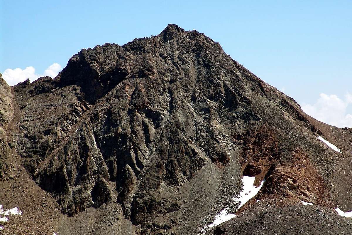
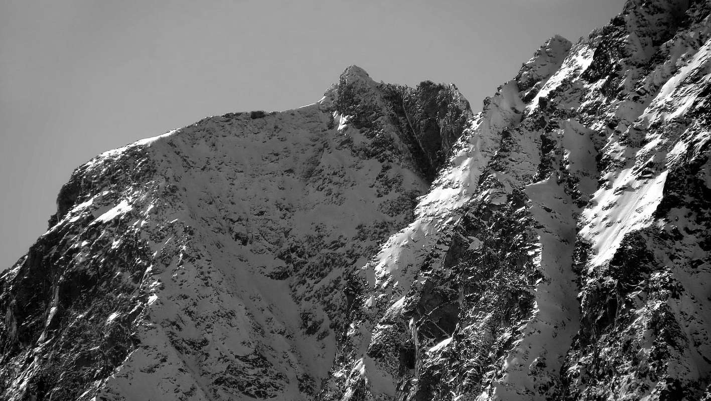
From Western view: the West, Southwest and South Slopes of Ilario Antonio Garzotto Point, doing up through Leppe Glacier in permafrost effect toward Leppe Pass (3.101m), on high of Laures Valley Basin. From left: Carving 3.185/90m about with a minuscle pinnacle and over the morainic Western Channel (to the left the beginning of Great's Roise South Ridge also Normal Route); North Ridge with Antesummit Northerner (3.230/5m around), near the Top. In foreground and frontally the West Wall with rocky various couloirs and ribs and small walls. In right side: South-Southwest Crest (reddish rocks into base), South Face or Standard Route and, outline right, South Crest. The three last, all over the hill between Laures Vallon and Saint Marcel Valley, by convergence on Antesummit Southerner (3.245/50m about).
Dal Colle di Leppe seguire su piccole e sempre meno marcate lungo il Versante Sud ed a mezza strada tra la Cresta Sud a destra (E) e quella S-SO all'opposto; proseguire tramite rocce rotte, dapprima sulla verticale, e poi poggiando leggermente a destra tramite sempre rocce rotte e scadenti, tenendosi a sinistra (Ovest) del filo di cresta, (I°/I°+, attenzione alla caduta di pietre!). Dopo aver lasciato sulla destra un bel gendarme di rossa roccia e solida caratterizzato da una laga fessura-camino, raggiungere così una fascia di rocce inclinate a S, sempre rossicce e maggiormente compatte; aggirandole sempre sulla sinistra, "rientrare" poi verso destra fino ad una spalletta con stretto intaglio sulla Cresta Sud. Da questo, lasciandosi sopra la prosecuzione della medesima, che con una quarantina di metri scarsi e con percorso alquanto aereo ed esposto, ma non difficile, raggiunge la Vetta (vedi sotto "Variante"), utilizzare un naturale diagonale ascendente formato da rocce molto rotte con detrito ed anche terriccio, appena al di sotto del filo della Cresta Sud. Terminare raggiungendo nei pressi della parte terminale della Cresta Nord vicino ad un ripido masso e giusto a ridosso della torretta sommitale, che si aggira aa O, superando un piccolo diedro inclinato e di pochi metri; oppure, poco prima di pervenire a questa, sfruttare sulla destra un canalino finale, di una dozzina di metri (II°-) e toccare la Croce, posta su di un terrazzino della Sommità Sud-Est (1h'00/1h'15, dal Colle di Leppe; 4h'00/4h'30 in totale). VARIANTE FINALE: come predetto, si possono anche salire dal piccolo intaglio, oltre la spalletta, integralmente gli ultimi 40 metri della Cresta Sud (II°/II°+, attenzione ad un grosso masso obliquo e pericolante; vedi varie foto), abbandonando l'omologo versante. Grande esposizione sulla Parete Est-nordest, che cade verticalmente verso le morene soprastanti l'Alpeggio di Rualla, ma con arrampicata divertente e più eccitante, tramite un breve passaggio impegnativo, proprio all'altezza del masso (tempo leggermente inferiore, vista la salita diretta evitando l'aggiramento sopra descritto).Discesa: per la stessa via di salita.
From Western with more great and detailed VIEW: the West, Southwest and South Slopes of Ilario Antonio Garzotto Point, toward Leppe Pass (3.101m). From left: the North Ridge with Antesummit Northerner (3.230/5m around), near the Summit. In foreground and frontally the West Wall with rocky various couloirs and ribs and small walls. In right side: South-Southwest Crest, South Face or Standard Route and, outline right, South Crest, watershed between the Laures small Valley and Saint Marcel Valley.
Difficulties
The route is for Expert Hikers with some alpinistic experience F+/PD+.
L'itinerario è da considerarsi F+/PD+.
Equipment
Mountaineering equipment including rope, helmet.
Da alpinismo, corda e casco.
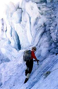
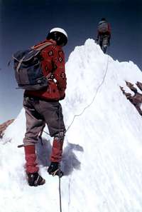
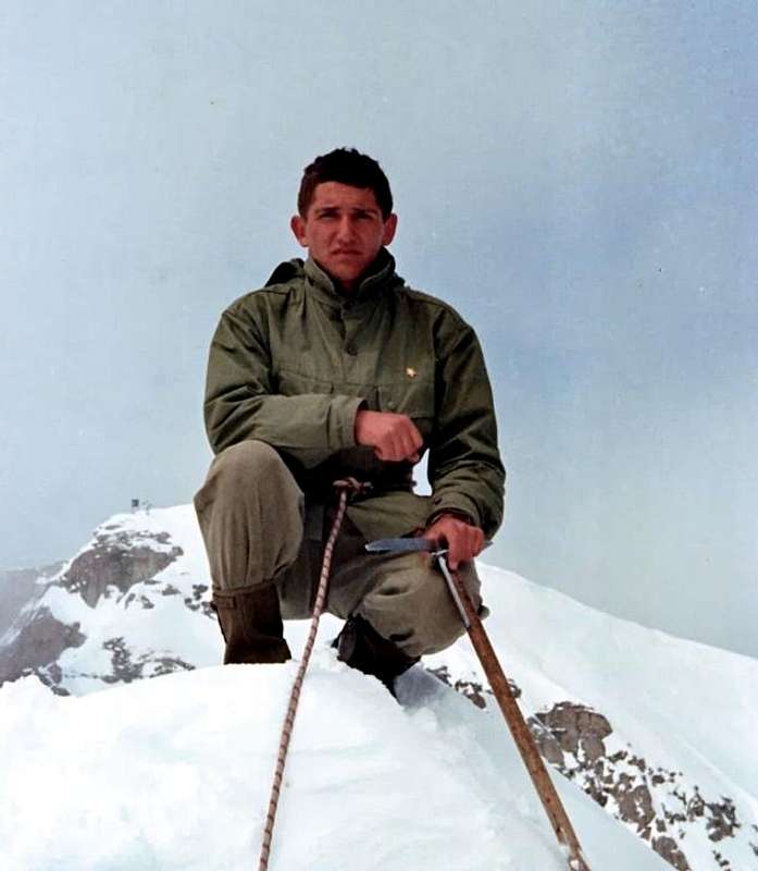
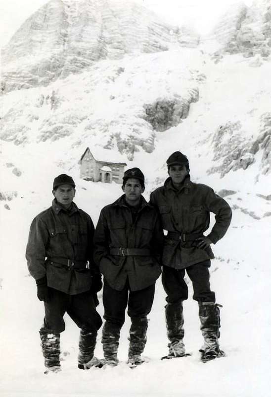
Old images "Photo d'Antan" of Ilario Antonio Garzotto
***
In ACTION
***
***
PHOTOGRAPHER
***
Chief ASCENTS & Principal Excursions
1964 Becca di Nona (3.142m): Normal Route on W-SW Slope and traverse to Carrel Hill through E-SE Crest. 1965Testa Nera (2.820m): Normal Route or NE Crest; Becca di Nona (3.142m): Normal Route on S-SW Slope; Monte Emilius (3.559m): Normal Route on S-SE Crest from Three Capuchins Pass (3.242m); Becca di Nona (3.142m): Normal Route on S-SW Slope and descent to Arpisson Vallon; Mont Fallère (3.061m): Normal Route on S-SW Slope and traverse to Punte Chaligne (2.608m); Testa Nera (2.820m): Standard Route or NE Crest; Pic Garin (3.461m):, through SE Crest of Great Shoulder 3.207/8m (New Route) and SW Ridge, descent by West Face of Shoulder 3.207/8m and traverse to Testa Nera (2.820m): Standard Route or NE Crest; Punta Rossa Central Summit (3.395m around): Nort Face in ascent and in descent (First Ascent). 1966 Becca di Nona (3.142m): Normal Route through S-SW Slope, lone; Punta del Dard (3.142m): E-SE Slope, directly from Pian Felina Fraction (559m) and Ponteilles Waterfall; Punta della Valletta (3.090m): through SW Crest from Tsa Setze Pass and crossing to Testa Nera (2.820m) and NE Crest in descent to Chamolé Hill; Gran Paradiso (4.061m): Normal Route with Renato Chabod Variant; Testa del Rutor (3.486m): Standard Route from La Joux; Becca di Nona (3.142m): North Wall, Little Gully of Left and Direct Exit Out, directly from Pian Felina (559m). New Route; Aiguille de Talèfre (3.870m): Standard Route through East Crest; Dent d'Hérens (4.182m): Standard Route through West Crest. 1967 Becca di Viou (2.856m): SW Wall in ascent (twice) and in descent (New Route) and crossing through Normal Route to Mont Mary (2.815m); Testa Nera (2.820m): W-NW Edge and descent by Standard Route or NE Crest; Fourquin de Bioula (2.965m): through East Crest or Chabod-Mila Route; Pain de Sucre (2.900m): through E-SE Crest (First Integral Route); Klein Matterhorn (3.880m): through NW Ridge with new variant; Petit Flambeau (3.365m): through South Crest or Standard Route; Tour Ronde (3.778m): North Wall with Direct Variant; Grandes Jorasses (4.274m): try failed for "verglass" on Reposoir's Rochers; Ciarforon (3.642m): North Wall in ascent and little SW Gully in descent with traverse to Becca di Monciair (3.544m) through NE Crest; Testa Nera (2.820m): North Wall Right Route (New) and descent by Normal Route; Becca di Nona (3.142m): North Wall, Little Gully of Left and Direct Exit Out, First Replay of 1966 Route; Testa Nera (2.820m): North Wall Right Route (New) and descent by Normal Route; Testa Nera (2.820m): North Wall Right Route (First Replay) and descent by Normal Route; Breithorn West (4.165m): by Normal Route. 1968CAMPAING since GENUARY 25th until SEPTEMBER 13th, 1968.
Gilberti Refuge (2.164m) at Monte Canin in winter; Becca di Viou (2.856m): Normal Route and traverse to Mont Mary (2.856m) in First Winter; Guglia De Amicis: "Via Dulfer I° ("Camini Via") and II° Torre del Sella through "Crack/Chimney" (2.533m; 2.597m) and traverse to Torre Grande di Averau (2.350m), by the Chimney of South Face; Olbe Lochs Refuge; Cima Grande di Lavaredo (2.998m): by Normal Route or Great SE Crest and South Face; Berti Refuge; San Marco and Galassi Shelters; Monte Antelao (3.263m): N-NW Ridge (first in season); P. Cosi Bivouac; Punta di Rocca of the Marmolada (3.309m): by Normal Route; Punta di Rocca of Marmolada (3.309m): by Normal Route (Replay); Pizzo Collina (2.691m): by Normal Route from Marinelli Refuge in Bos's Valley; Pizzo Collina (2.691m): by Normal Route (repetition); Refuge Guido Corsi: with crossing towards Forcella del Vallone, Bivouac C.AI. Gorizia (1950m). Cime Castrein (2.502m): by Normal Route from C.AI. Gorizia Bivouac and through the Lavinal dell'Orso Collar (2.158m) towards Mosé Collar (2.271m); Jof Fuart (2.666m): by Direct Route on South Wall through "Cengia degli Dei"; Ago di Villaco (2.050m): by South Edge; Campanile di Villaco (2.247m): by South Couloir; Torre della Madre dei Camosci (2.503m): by gully; Innominata (2.463m): through Riofreddo Collar-South Wall of Cima di Riofreddo traverse-"Cengia degli Dei" and a couloir in final part; Jof Fuart (2.666m): Standard Route; Punta Aouilletta (2.616m): with crossing to Punta Paletta (2.771m) and Monte Rosso of Vertosan (2.943m), round trip; Costa di Chamolé (2.580m) and crossing to Testa Nera (2.820m), through NE Crest with descent on W-NW Slope; Becca di Roisan (2.546m): from Parléaz Village and Normal Route.
1969 Croux de Fana (2.212m): from Trois Villes Village and Normal Route through S-SE Slope; Costa di Chamolé (2.580m) and crossing to Testa Nera (2.820m), through NE Crest with descent on W-NW Slope; Quota also "Becca of Blavy" (2.494m) by West little Wall (New Route) and crossing to Becca of Roisan (2.546m), through S-SE Crest with descent on South Slope; Brèche of Tacul and try to Tacul Trident failed for high snow; Punta Jean Charrey of the Arolletta Trident (2.900m) East Edge or Bozzetti-Rosset Via; Punta de la Pierre (2.553m): from Pila Resort and Normal Route through East Slope; Croux de Fana (2.212m): from Trois Villes Village and Normal Route through S-SE Slope; Testa Nera (2.820m): by Standard Route or NE Crest and traverse through North Ridge towards Mont Belleface (2.970m) and Punta della Valletta (3.090m), round-trip; Gran Paradiso (4.061m): NW Wall Mixed Route, through icy face and Crétier Via in terminal part (New Route) and descent by Normal Route or S-SW Slope; Becca di Monciair (3.544m): by North Wall (First of the season) and descent through Standard Route or NE Crest; traverse to Northern base of Ciarforon and North Wall ((3.642m; first ascent of two faces in day) and descent by NE Crest; Mont Paramont (3.300m): by North Wall (Third Ascent) and descent through Normal Route or West Crest; Punte Patrì Northern and Southern (3.558m; 3.579m): by NW Wall or Guichardaz-Cammelli Route (First Replay), crossing of two points and descent through South Slope or Standard Route to Coupé de Money Pass (3.383m); traverse towards Torre di Sant'Orso (3.618m), by West Face and traverse to Cresta Paganini (3.447m), with descent through North Face Diagonal "Via" (New Route); Monte Emilius (3.559m): by East Wall Right "Via" (New Route and Fourth Ascent), with descent through East Crest to Laures Vallon; Col du Trident (3.679m) and Ghiglione Bivouac; Col Moore (3.479m) and Mont Blanc (4.811m) through Brenva E'peron or "Via" Moore; descent by Normal Route towards Dome de Gouter (4.306m) to Gonella Shelter; Eastern Lyskamm (4.527m) through Perazzi Crest and traverse towards Western Lyskamm (4.477m), Punta Félik (4.216m), Punta Castore (4.225m) to Sella Hut; Petit Capucin of Tacul (3.693m): by East Wall Gervasutti "Via", with descent through West Crest or Normal Route to Carabinier Eastern Brèche (3.585m around); Quota also "Jag of Becca" (2.736m; First Crossing North/South?) and traverse to Becca di Nona (3.142m), by N-NE Great Crest Crétier "Via" (New Route with First Integral Ascent on watershed); Punta de la Pierre (2.653m) - Punta del Drink (2.653m) - Quota also Punta del Couiss (2.661m)-Piatta di Grevon (2.756m) - Punta di Monpers (2.793m)-Quota 2.783m - Punta della Valletta (3.090m), by SW Crest (First Integral)-Mont Belleface (2.970m) - Testa Nera (2.820m) Traverse. Aiguille Jean Joseph Croux (3.251m), S-SE Wall, "Arthur Ottoz Via" from Guido Monzino Refuge (2.561m); a violent death for fall. SEPTEMBER 29th, 1969; 09h'30~ Hour.
Various
The Punta Ilario Antonio Garzotto (3.273/4m) from North-northeast and over the Saint Marcel Valley, on Mulac-Saint Louis Hunting House (1.937m) and Rualla Alp (2.259m), immediately before the Great Chaux (2.370/91m) Pastures and Westerner moraines. In evidence, from left (Est) the East-southeast Crest with the Great East Shoulder 3.220/30m around (the crest of Steinbocks), the small castle of the Summit, over the North-northeast Wall, the Antesummit Northerner (3.230/5m around) and the North Ridge to carving 3.185/90m about. In the right, partially, the steep East Wall of Great Roise (3.357m).
"Guida delle Alpi Occidentali" di Giovanni Bobba e Luigi Vaccarone C.A.I. Sezione di Torino Volume II (parte II), 25 Maggio 1896.
"Guida del Monte Emilius" di Osvaldo Cardellina Editore in collaborazione con il Club Alpino Italiano Sezione di Aosta, Dicembre 1978 (in Italian).
"Ascensioni 1964-1969" Diario Alpinistico di Ilario Antonio Garzotto (unpublished).
"Diari Alpinistici" di Osvaldo Cardellina e Indice Generale accompagnato da Schedario Relazioni Ascensioni 1964-2019 (unpublished).
"Guida dei Monti d'Italia – Emilius Rosa dei Banchi-Parco del Mont Avic" di Giulio Berutto e Lino Fornelli - Club Alpino Italiano/Touring Club Italiano, Marzo 2005.
MAPS:
Kompass "Gran Paradiso Valle d'Aosta Sentieri e Rifugi" Carta Turistica 1:50.000.
Hapax "Les Sentiers" Comunità Montana Monte Emilius, Luglio 2000 1:25.000.
Enrico Editore Ivrea-Aosta "Gruppo del Gran Paradiso" 1:50.000.
L'Escursionista "Valle di Cogne" Carta dei Sentieri 1:25.000.
L'Escursionista "Tour de la Vallée de Cogne Grand Paradis" Carta dei Sentieri 1:25.000.
Hapax "Les Sentiers de Charvensod" Comune di Charvensod, Giugno 2003 1:25.000.
Parents refers to a larger category under which an object falls. For example, theAconcagua mountain page has the 'Aconcagua Group' and the 'Seven Summits' asparents and is a parent itself to many routes, photos, and Trip Reports.

 21834 Hits
 91.14% Score
 34 Votes