
-
 3776 Hits
-
 73.06% Score
-
 3 Votes
|
|
Route |
|---|---|
|
|
28.22580°N / 16.6988°W |
|
|
Hiking, Scrambling |
|
|
Spring, Summer, Fall, Winter |
|
|
Most of a day |
|
|
Hike and Scramble |
|
|
Overview
The round trip across the four mountains on the caldera rim to the west of the Cañadas del Teide is among the most beautiful on the island of Tenerife. However, it is not among the easiest of hikes, especially since orientation in the rockky terrain can be quite difficult. In 2002, when I did this tour there were only a few markers and in fact we met somebody who (illegally) marked the path with green dots. Since then much has changed. For much of the route the path is quite clearly visible but there still are difficult sections to the north of Montaña del Cedro, to the north and south of the Roques de Chavao and to the south of Montaña Gangarro.The trail first follows the base of the Caldera walls and winds through lava fields, later crisscrosses up and down the summits along the crater wall. There are also different alternatives for reaching Montaña del Cedro and Roques del Cedro and a shortcut to the Roques de Chavao.
Getting There
You can reach the Cañadas del Teide from all sides. Just drive as far upwards as you can and you'll be there. From the south there is a road from the airport via Villaflor to the Cañadas, from the West you must head for Chio either from Playa de las Americas or from Santiago del Teide. The northern road starts from Puerto de la Cruz and the eastern ascent starts from the capital Santa Cruz del Tenerife and crosses the mountain range Cumbre Dorsal.Alternatively you can take the bus either from Playa de las Americas (Line 342) or from Puerto de la Cruz (Line 348). Both buses depart at about 9:00 a.m., the return buses go around 4:00 p.m. They both stop at the trailhead at Boca Tauce
Route Description
- Start altitude: 2055m
- Summit altitude: 2265m
- Prevailing exposure: E
- Type: 5h over marked paths
- Protection: None
Stage 1: Easy hike underneath the walls

From the parking lot (mirador) at Boca Tauce follow the road in direction Villaflor for about 200m. Here a dirt road turns off to the right leading directly towards the east face of Montaña Gangarro. It sooon turns into a path and heads for the Roques de Chavao. After having passed the many towers underneath Montaña Gangarro the path heads out into the huge black lava flow, coming down from Pico Viejo. It passes the two largest towers of the Roques Chavao through the lava, then heads for Boca Chavao between the Roques and Montaña del Cedro.
Here a dirt road coming down from the Boca joins the path. Follow the road, passing Montaña del Cedro and Roques del Cedro. After a turn and after the bulk of the Roques del Cedro have been passed, a marked trail heads up in direction of the Roques del Cedro summits.
Stage 2: Roques del Cedro
The path heads up towards a shoulder to the north of the main rocks and towers of the Roques del Cedro. Once on the ridge turn left (south) and follow the trail which now passes severall of the larger rocks on their inner (eastern) side, then gains the summit plateau. The highest point is on one of the smaller rocks growing out of the plateau.
Stage 3: Montaña del Cedro

Descending from the Roques del Cedro along the southern ridge is relatively easy. The path winds among some smaller rocks down into the col between the Roques and Montaña del Cedro. But here the first orientation problems soon start. While the very first part of the ascent is still obvious soon the path turns right (west) heading through some thick brushwork. It winds its way through the Montaña del Cedro north face but finally gains the shallow western side of the mountain. From here the summit plateau is easily gained.
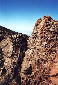
Stage 4: Roques de Chavao

The following descent to Boca de Chavao is easy, but again orientation is the problem. Stay as close as possible to the walls, which drop into the caldera. Not only are the views far better than in the forest to the west but also there are some cairns every now and again. The path gets more obvious as you near Boca de Chavao.
From here you have to climb a small hill and descend into a second col, from where the ascent of the Roques de Chavao starts. The easy path soon turns into a scarcely marked scramble along basalt blocks. Several basaltic lava walls bar the way and have to be circumvented on their upper (western) side. Between the walls and the summit the orientation and the scramble get most difficult, sometimes even a bit exposed. The summit structures offer nice and comfortable lookout positions.
Stage5: Montaña Gangarro

This stage is the easiest of the lot. Descend into the col between the Roques and Montaña Gangarro. There are lots of Canarian pines obstructing the views, also there are numerous of the huge Taginaste flowers along the
way. The ascent of Montaña Gangarro is as easy as the descent from the Roques de Chavao. The summit doesn't offer too much space and the views are rather limited.
Stage 6: Back to Base

In 2002 this was the hardest part of the climb. Orientation is no problem but you have to downclimb a narrow chimney, which - without aid - is rather difficult. In 2007 we found a large tree trunk within this chimney which facilitated the descent a lot. The remainder of the route is rather easy, though it runs along scree covvered rocks and thus is rather slippery. There is a large rock which has to be passed on its eastern side and soon you are at the road from which you started.